WKN Weer, Klimaat en Natuurrampen
Lees alles over het onstuimige weer op onze planeet, volg orkanen en tornado's, zie hoe vulkanen uitbarsten en hoe Moeder Aarde beeft bij een aardbeving. Alles over de verwoestende kracht van onze planeet en tal van andere natuurverschijnselen.


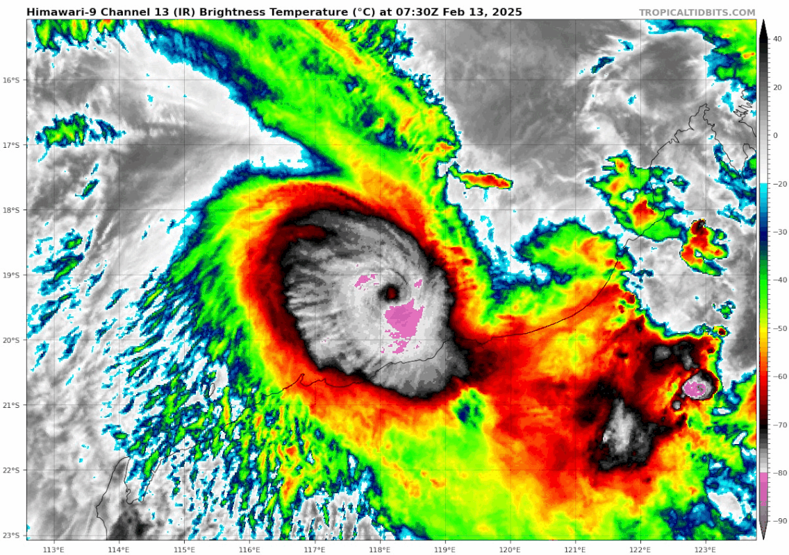
Categorie 5 orkaan (Zelia) voor west Australië
Een tropische cycloon van categorie 5 (de sterkste op de schaal van Saffir en Simpson) met het vermogen om wijdverspreide verwoestingen te veroorzaken, komt op de kustregio Pilbara in West-Australië af.
Volgens het Australische weerbureau beweegt Zelia langzaam en zal het laat vrijdag het vasteland raken in een regio waar belangrijke havens voor de export van grondstoffen, waaronder ijzererts, gelegen zijn en die tevens een verwerkingscentrum vormen voor olie- en gasleveranties.
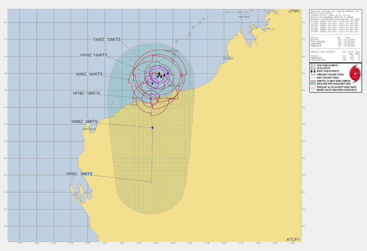
De kerndruk is nu 929 mb en zal nog verder dalen. Het windveld loopt op naar 230 km met windstoten tot 277 km. Dit zal toenemen tot een windveld van 260 km met windstoten tot 315 km.
Een tropische cycloon van categorie 5 (de sterkste op de schaal van Saffir en Simpson) met het vermogen om wijdverspreide verwoestingen te veroorzaken, komt op de kustregio Pilbara in West-Australië af.
Volgens het Australische weerbureau beweegt Zelia langzaam en zal het laat vrijdag het vasteland raken in een regio waar belangrijke havens voor de export van grondstoffen, waaronder ijzererts, gelegen zijn en die tevens een verwerkingscentrum vormen voor olie- en gasleveranties.
De kerndruk is nu 929 mb en zal nog verder dalen. Het windveld loopt op naar 230 km met windstoten tot 277 km. Dit zal toenemen tot een windveld van 260 km met windstoten tot 315 km.
v
quote:Residents in Western Australia are preparing for Tropical Cyclone Zelia, with the storm expected to cross the coast at Port Hedland as a category 4 storm tomorrow.
Mother Nature's Valentine's Day gift is forecast to bring damaging wind gusts above 200km/h and more than 500mm of rain, which could cause flooding that cuts off major roads for up to a week.
The warning zone of the slow moving weather system extends 700km from Bidyadanga to Dampier, including Port Hedland, Karratha and Dampier, and extending inland to Marble Bar.
The storm was upgraded to a category 3 overnight and estimated to be 135km north of Port Hedland and travelling south-west at 13km/h, allowing it to gather strength over water.
The port - the world's largest bulk export port - has closed as the mining hub prepares for the cyclone. Some schools have shuttered and flights have been cancelled from today.
Supermarkets are also working to get extra supplies into the region, about 1600km north of Perth, before roads are cut off.
An extra 40 emergency services personnel have been deployed to the Pilbara region as well as five flood boats with 10 crews, and four additional aircraft are on standby, including a rescue chopper with a winch.
Bureau of Meteorology state manager for Western Australia James Ashley said the system was "expected to take a bit of a wobble to the west" overnight before resuming a southwards motion today.
"A real feature of this system is that it's quite erratic and slow-moving off the Pilbara coast," Ashley said.
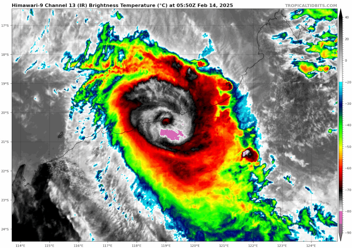
The heaviest falls are forecast to start today and continue through tomorrow, coming off the eastern flank of the system as Zelia approaches and crosses the coast.
It's expected to dissipate quickly once it makes landfall, becoming a tropical low by Saturday.
Some content couldn’t be displayed in Google AMP. To see what’s missing visit the full article here.
Meteorologists also warned residents between Port Hedland and Bidyadanga of the potential of a dangerous storm tide as the cyclone centre crosses the coast.
"Tides are likely to rise significantly above the normal high-tide mark with damaging waves and dangerous flooding of some low-lying areas close to the shoreline," the Bureau of Meteorology said.
Gales with damaging wind gusts of 120km/h are developing near the coastal fringe between De Grey and Wallal Downs.
https://news.google.com/r(...)U&gl=AU&ceid=AU%3Aen
v

Tuinmeubilair maar even binnen zetten.
Als iedereen aan zichzelf denkt wordt er aan iedereen gedacht.
Op 't randje en erover.
Op fietsen zonder bende kwam'm zie schooieren um spek
Op 't randje en erover.
Op fietsen zonder bende kwam'm zie schooieren um spek
Tjees windstoten van 315km/h, dat wordt lastig in blijven staan zeg 
Je merkt wel dat de orkanen steeds meer in kracht aan het toenemen zijn.
Je merkt wel dat de orkanen steeds meer in kracht aan het toenemen zijn.
Doe mee met het voorspellen van het weer!
Weekvoorspelling -- Week 1
Maandvoorspelling februari.
Jaarvoorspelling 2024 --- Jaarvoorspelling 2025!
Weekvoorspelling -- Week 1
Maandvoorspelling februari.
Jaarvoorspelling 2024 --- Jaarvoorspelling 2025!
Wat havens daar, maar verder wonen er weinig mensen in die regio. Ben eigenlijk wel benieuwd wat zoveel water teweeg zal brengen in de woestijn daar.
|
|