WKN Weer, Klimaat en Natuurrampen
Lees alles over het onstuimige weer op onze planeet, volg orkanen en tornado's, zie hoe vulkanen uitbarsten en hoe Moeder Aarde beeft bij een aardbeving. Alles over de verwoestende kracht van onze planeet en tal van andere natuurverschijnselen.


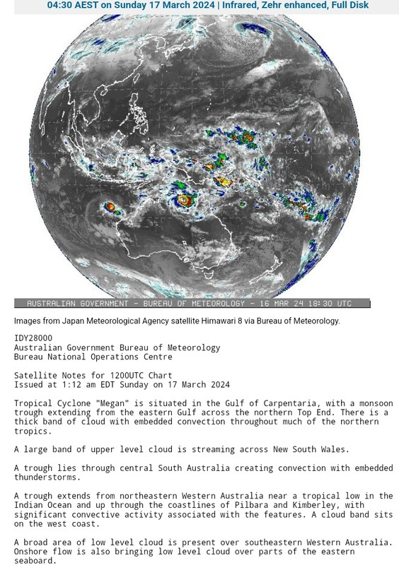
Tropische cycloon Megan beweegt zich richting de kust van Top End
Inwoners van Top End (Australië) zijn gewaarschuwd voor tropische cycloon Megan, die zich richting de kust beweegt. De waarschuwingszone voor het systeem, nu nog een tropische storm, strekt zich uit over honderden kilometers van Alyangula in het noordoosten van het Northern Territory langs de kust tot aan de grens met Queensland. Verwacht wordt dat het zondagavond een orkaan (categorie 1) zal worden voordat het maandagochtend de kust bereikt.
Inwoners van Top End (Australië) zijn gewaarschuwd voor tropische cycloon Megan, die zich richting de kust beweegt. De waarschuwingszone voor het systeem, nu nog een tropische storm, strekt zich uit over honderden kilometers van Alyangula in het noordoosten van het Northern Territory langs de kust tot aan de grens met Queensland. Verwacht wordt dat het zondagavond een orkaan (categorie 1) zal worden voordat het maandagochtend de kust bereikt.

quote:The Bureau of Meteorology said the cyclone would have a "very destructive core" when it made landfall, with wind gusts of up to 185km/h expected from the Nathan River in the NT down to Queensland.
Severe conditions were expected from early Sunday, with meteorologist Miriam Bradbury warning communities to expect sustained gale-force winds and damaging gusts of up to 100km/h.
"We could see trees and tree limbs downed by these winds, leading to debris on the roads and potentially disrupted transport routes," Ms Bradbury said.
She warned communities outside the tropical cyclone warning zone could still feel the impacts of wind and rain, with a severe weather warning for heavy rainfall issued in the East Arnhem district.
"Twenty-four-hour rainfall totals could exceed 200 millimetres, which can lead to flash flooding," Ms Bradbury said.
The weather system is expected to return to a tropical low as it heads further inland on Tuesday and Wednesday, prompting the bureau to issue flood watches for further river rises across the territory.
Abnormally high tides are likely along the gulf's coast and large waves could produce minor flooding along the foreshore, the bureau said.
It comes one month after category one ex-tropical Cyclone Lincoln crossed the territory's coast in the southern Gulf of Carpentaria, bringing high winds and heavy rainfall.
https://www.canberratimes(...)ards-top-ends-coast/

De kerndruk is gedaald naar 962mb. Dat is vergelijkbaar met een categorie 3 orkaan op de schaal van Saffir en Simpson.
Tsr heeft het nu op een categorie 2 staan bij landfall.
Tsr heeft het nu op een categorie 2 staan bij landfall.

Megan verplaats tergend langzaam richting de kust, waardoor er inmiddels een gigantische hoeveelheden regen valt. En zo lang de kern boven het warme water van de golf van Carpentaria blijft, kan de orkaan nog toenemen in kracht. Het water zit hier op 31 graden, wat kan zorgen voor een zeer zware orkaan.
quote:Over 650mm forebodes Tropical Cyclone Megan's arrival
After dumping half a year's worth of rainfall over Groote Eylandt in the past 48 hours, Tropical Cyclone Megan is building strength in the Gulf of Carpentaria and will make landfall over the NT coast on Monday night.
Tropical Cyclone Megan formed on Saturday afternoon in the Gulf of Carpentaria, making it the fifth tropical cyclone to impact the Australian region this season.
Tropical Cyclone Megan intensified overnight, dropping enormous amounts of rainfall over Groote Eylandt, Australia’s fourth largest island, which sits on the western side of the Gulf of Carpentaria.
https://www.weatherzone.c(...)an-s-arrival/1856992
|
|