WKN Weer, Klimaat en Natuurrampen
Lees alles over het onstuimige weer op onze planeet, volg orkanen en tornado's, zie hoe vulkanen uitbarsten en hoe Moeder Aarde beeft bij een aardbeving. Alles over de verwoestende kracht van onze planeet en tal van andere natuurverschijnselen.


Jaloers. Hier is 10 cm papsneeuw gevallen, ligt gewoon een slush puppy op straatquote:Op donderdag 11 maart 2021 06:56 schreef aloa het volgende:
Zwaarste windstoot voor Vlieland. 94 km. En dan moeten de zwaarste nog komen.
"For the man sound of body and serene of mind, there is no such thing as bad weather; Every day has its beauty. And storms which whip the blood, do make it pulse more vigorously."

Heb je niks aan idd.quote:Op donderdag 11 maart 2021 07:19 schreef Dven het volgende:
[..]
Jaloers. Hier is 10 cm papsneeuw gevallen, ligt gewoon een slush puppy op straat
94257 - 478969
In my dreams I'm dying all the time
In my dreams I'm dying all the time

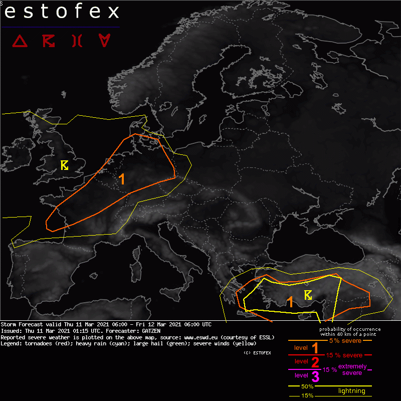
Ff weer een keer estofex posten.quote:A level 1 was issued across north-western France into the Benelux countries and northern and central Germany mainly for severe wind gusts.
DISCUSSION
A strong zonal jet expands across western Europe ahead of an intense Atlantic trough. Downstream, an east-European trough amplifies and diggs across the east Mediterranean. Ahead of this trough, a very strong mid-level jet affects the east Mediterranean. Cold and dry air masses are present across north-eastern Europe. Ridging affects the south-western portions.
DISCUSSION
France into Germany
An intense low pressure system will affect the area with strong to severe wind gusts. Some convective contribution to these gusts is expected. Main focus is the mid-level front that is associated with steep low- to mid-level lapse rates. These may even overlap with the cold front that crosses Germany during the day, so that pre-frontal moisture with dewpoints around 6°C can overlap with modest low-level lapse rates. Weak low-topped CAPE is not ruled out. In the wake of the cold front, further showers and thunderstorms are forecast in an slightly unstable environment.
Given very strong vertical wind shear already at low levels, thermodynamic profiles indicate a typical high-shear, low-CAPE environment. Showers and thunderstorms will have the potential to produce severe wind gusts, especially along bowing segments. Additonally, low-topped mesocyclones may produce tornadoes.
The main limiting factor is the rather weak cold pool potential and the weak low-level convergence indicated by latest models. A well-developed narrow cold-frontal rain band is not indicated by most models, but a broken line or isolated segments of convection. Overall contribution of convective storms to the severe wind gusts occurrence is forecast to be limited for this reason.
Bleek met name in één gedeelte van de tuin te zijn, ik vermoed waar er veel smeltwater gevallen is. Op de meeste plekken is het toch wel een dikke laag verse sneeuw. We stellen de lente nog maar even uitquote:
"For the man sound of body and serene of mind, there is no such thing as bad weather; Every day has its beauty. And storms which whip the blood, do make it pulse more vigorously."
Meeste plekken van het land windstoten die zo rond de 8 tot 10 op de schaal van richter liggen. Aan de kust is er al effectief sprake van storm (gemiddelde over tien minuten van 9 Beaufort) en het zwaartepunt ligt in de komende uren.quote:Op donderdag 11 maart 2021 09:24 schreef Scheepskok het volgende:
Welke storm? Niks aan de hand hier.

"For the man sound of body and serene of mind, there is no such thing as bad weather; Every day has its beauty. And storms which whip the blood, do make it pulse more vigorously."
Klopt ja, dat veld blijft daar ook nog iets van 6 dagen liggen, de rest van het land blijft zoals het is.quote:
[..]
Alleen dat stukje Zuid-Holland dus.
"For the man sound of body and serene of mind, there is no such thing as bad weather; Every day has its beauty. And storms which whip the blood, do make it pulse more vigorously."

Zo maar eens met de hond eruit.
Beestje van 8,5 kilo en ik heb een 8 meter lijn, dus ik kán er mee vliegeren
Beestje van 8,5 kilo en ik heb een 8 meter lijn, dus ik kán er mee vliegeren
Perhaps you've seen it, maybe in a dream.
A murky, forgotten land.
A murky, forgotten land.
Schokkendquote:
[..]
Meeste plekken van het land windstoten die zo rond de 8 tot 10 op de schaal van richter liggen.
Lolquote:
 Op
Op Te mooi om te herstellen
"For the man sound of body and serene of mind, there is no such thing as bad weather; Every day has its beauty. And storms which whip the blood, do make it pulse more vigorously."
Zou wat zijn. Van een stormpje naar de grootste aardbeving in de geschiedenis  Nederland zou weggevaagd worden.
Opgeblazen gevoel of winderigheid? Zo opgelost met Rennie!
Hier in Twente trekt de wind nu weer aan, nadat we even mooie opklaringen hadden.
Ik hoop dat het meevalt, ik wil geen vallende dakpannen
Ik hoop dat het meevalt, ik wil geen vallende dakpannen
I'm gonna love you 'til the heavens stop the rain
I'm gonna love you 'til the stars fall from the sky
For you and I
I'm gonna love you 'til the stars fall from the sky
For you and I
Deze wind in combinatie met regen. Mijn hemel.
Op maandag 9 september 2013 21:44 schreef Kapt-Ruigbaard het volgende:
Abs are made in the kitchen.
Abs are made in the kitchen.
Nu begint het pas leuk te worden. Ik heb de bovenraampjes dicht moeten doen, want het begon te klapperen in huis.
Praat over de hel en je komt er.
Wanneer bereiken we de piek?
Saaie pluim trouwens, lange termijn voor zover dat wat waard is 10 graden en aardig wat neerslag... Vlees noch vis.
Saaie pluim trouwens, lange termijn voor zover dat wat waard is 10 graden en aardig wat neerslag... Vlees noch vis.
blablablabla
Als ik de weermodellen moet geloven dan zijn we net over de piek heen.quote:
Wanneer bereiken we de piek?
Saaie pluim trouwens, lange termijn voor zover dat wat waard is 10 graden en aardig wat neerslag... Vlees noch vis.

Het is hier al de hele ochtend droog met af en toe zon.....en een beetje wind
Ik kan het je wel uitleggen maar het niet voor je begrijpen........
Limburg?quote:
Het is hier al de hele ochtend droog met af en toe zon.....en een beetje wind
Op woensdag 10 juli 2013 01:46 schreef Littlerabbit het volgende:
Djeez is een literaire grootheid. Hij weet op een poëtische wijze zelfs de schoonheid in een kinderverkrachting bloot te leggen. Tuinbeeld kopen?
Djeez is een literaire grootheid. Hij weet op een poëtische wijze zelfs de schoonheid in een kinderverkrachting bloot te leggen. Tuinbeeld kopen?