WKN Weer, Klimaat en Natuurrampen
Lees alles over het onstuimige weer op onze planeet, volg orkanen en tornado's, zie hoe vulkanen uitbarsten en hoe Moeder Aarde beeft bij een aardbeving. Alles over de verwoestende kracht van onze planeet en tal van andere natuurverschijnselen.


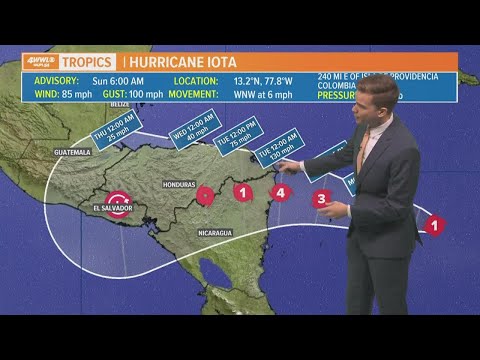
Opnieuw zware orkaan voor Midden Amerika
Orkaan Iota is een categorie 1 orkaan met een kerndruk van 977 mb en trekt westwaarts in de richting van Nicaragua en Honduras. Volgens diverse modellen zal de orkaan nog verder in kracht toenemen tot mogelijk een categorie 3 of 4.
Iota volgt op orkaan ETA, die in dit gebied al voor veel doden heeft gezorgd ( hier staat het topic over ETA ). De neerslagverwachting loopt op tot +50 cm.
Zie ook: WKN / [ACTUEEL] Hurricane Season 2020 #2
Orkaan Iota is een categorie 1 orkaan met een kerndruk van 977 mb en trekt westwaarts in de richting van Nicaragua en Honduras. Volgens diverse modellen zal de orkaan nog verder in kracht toenemen tot mogelijk een categorie 3 of 4.
Iota volgt op orkaan ETA, die in dit gebied al voor veel doden heeft gezorgd ( hier staat het topic over ETA ). De neerslagverwachting loopt op tot +50 cm.
quote:The storm known as Iota rapidly strengthened into a hurricane early Sunday and is expected to slam into storm-ravaged Central America in the coming days.
Iota is forecast to make landfall as a Category 4 with sustained winds of at least 130 mph late Monday night or early Tuesday. It will be the second major hurricane to hit the region in the past two weeks. On November 3, Hurricane Eta made landfall as a Category 4 storm, causing landslides and flooding that left scores of people dead or missing.
Iota, which formed Friday at sea, was centered in the Caribbean about 335 miles east-southeast of the Nicaragua-Honduras border with maximum sustained winds of 90 mph as of 10 a.m. ET Sunday, the US National Hurricane Center said. It is forecast to continue to rapidly strengthen over the next 24 hours.
Iota -- the 13th hurricane of the 2020 Atlantic hurricane season -- is expected to continue heading west and make landfall somewhere in Central America, potentially near the Honduras-Nicaragua border by late Monday or early Tuesday, CNN meteorologist Tyler Mauldin said.

Zie ook: WKN / [ACTUEEL] Hurricane Season 2020 #2

Kracht neemt duidelijk toe. Hwrf laat een kerndruk rond de 940 mb zien bij landfall, wat past bij een categorie 4.


Tijdelijk kickje NWS
In slechts 70 minuten van 943,9 mbar naar 931,3 mbar...
Zit op randje categorie 5...zwaarste orkaan van 2020 voor het Atlantische seizoen
[ Bericht 54% gewijzigd door Frutsel op 16-11-2020 12:57:46 ]
In slechts 70 minuten van 943,9 mbar naar 931,3 mbar...
Zit op randje categorie 5...zwaarste orkaan van 2020 voor het Atlantische seizoen
[ Bericht 54% gewijzigd door Frutsel op 16-11-2020 12:57:46 ]

917 mb gemeten nu. Daarmee word het een categorie 5. Windsnelheid ver boven de 250 km.
[ Bericht 9% gewijzigd door #ANONIEM op 16-11-2020 13:35:18 ]

[ Bericht 9% gewijzigd door #ANONIEM op 16-11-2020 13:35:18 ]
Dus toch nog een categorie 5 dit jaar. En dat in half november!
Sterkte aan de mensen in get getroffen gebied. Misschien dat net zoals bij Eta een eyewall replacement cycle de schade nog een beetje kan beperken.
Sterkte aan de mensen in get getroffen gebied. Misschien dat net zoals bij Eta een eyewall replacement cycle de schade nog een beetje kan beperken.

Ze houden het nu op 921 mb. Wat net geen cat 5 is (wat luchtdruk betreft). Heeft dat te maken met een correctie ofzo?
Even afwachten wat er nu verder nog gemeten gaat worden.
Even afwachten wat er nu verder nog gemeten gaat worden.

Dat ging snel naar een 5
Never Stop Exploring!
Life begins at the end of your comfort zone!
Follow me on Twitter: https://twitter.com/EdwinKr83 Instagram: https://www.instagram.com/edwinkr83/
Life begins at the end of your comfort zone!
Follow me on Twitter: https://twitter.com/EdwinKr83 Instagram: https://www.instagram.com/edwinkr83/
|
|