WKN Weer, Klimaat en Natuurrampen
Lees alles over het onstuimige weer op onze planeet, volg orkanen en tornado's, zie hoe vulkanen uitbarsten en hoe Moeder Aarde beeft bij een aardbeving. Alles over de verwoestende kracht van onze planeet en tal van andere natuurverschijnselen.


Cristobal zorgt voor overstromingen in Mexico.
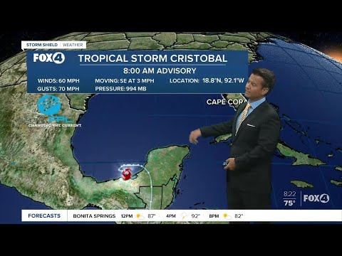
De derde tropische storm met een naam is een feit voor het Atlantische orkaanseizoen. Nog nooit ontstond de derde storm met naam zo vroeg in de Atlantische Oceaan. Deze storm heeft de naam Cristobal gekregen en lig nu voor de kust van Mexico.
Waarschijnlijk blijft deze storm de komende dagen zo'n beetje op dezelfde plek liggen, waardoor in het het zuiden van Mexico extreme hoeveelheden neerslag kan gaan vallen. Plaatselijk kan dit oplopen tot meer dan 750 mm. Gevolg hiervan zijn overstromingen en landverschuivingen, met alle gevolgen die daar bij horen.
De verwachting is dat de storm uiteindelijk nog de VS een bezoek gaat brengen, maar het is nog niet helemaal duidelijk over hoe krachtig de storm dan nog zal zijn.
Lees ook: WKN / Hurricane Season 2020: Eindelijk een rustig jaar of weer niet?
De derde tropische storm met een naam is een feit voor het Atlantische orkaanseizoen. Nog nooit ontstond de derde storm met naam zo vroeg in de Atlantische Oceaan. Deze storm heeft de naam Cristobal gekregen en lig nu voor de kust van Mexico.
Waarschijnlijk blijft deze storm de komende dagen zo'n beetje op dezelfde plek liggen, waardoor in het het zuiden van Mexico extreme hoeveelheden neerslag kan gaan vallen. Plaatselijk kan dit oplopen tot meer dan 750 mm. Gevolg hiervan zijn overstromingen en landverschuivingen, met alle gevolgen die daar bij horen.

De verwachting is dat de storm uiteindelijk nog de VS een bezoek gaat brengen, maar het is nog niet helemaal duidelijk over hoe krachtig de storm dan nog zal zijn.

Lees ook: WKN / Hurricane Season 2020: Eindelijk een rustig jaar of weer niet?
94257 - 478969
In my dreams I'm dying all the time
In my dreams I'm dying all the time


 Op
Op
Never Stop Exploring!
Life begins at the end of your comfort zone!
Follow me on Twitter: https://twitter.com/EdwinKr83 Instagram: https://www.instagram.com/edwinkr83/
Life begins at the end of your comfort zone!
Follow me on Twitter: https://twitter.com/EdwinKr83 Instagram: https://www.instagram.com/edwinkr83/


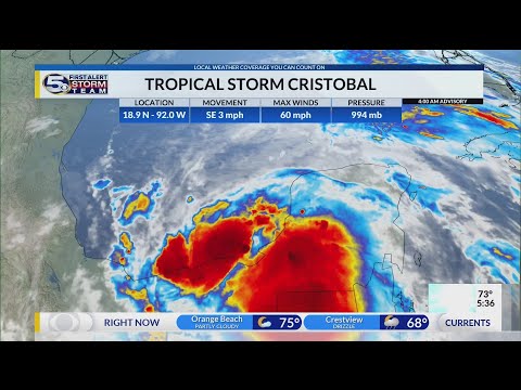
Systeem ligt nu voor de kust van de VS en zal landfall maken in de buurt van New Orleans. Hier kan tot meer dan 250 mm regen gaan vallen. Ook bestaat de kans, dat er tornado's gaan ontstaan. Een eerste watch is inmiddels uitgegeven door Noaa.
Voor een groot deel van de kust is gewaarschuwd voor tropische storm. Bijkomend probleem is dat er vandaag springtij is, waardoor het water nog extra hoog zal worden.
Voor een groot deel van de kust is gewaarschuwd voor tropische storm. Bijkomend probleem is dat er vandaag springtij is, waardoor het water nog extra hoog zal worden.


94257 - 478969
In my dreams I'm dying all the time
In my dreams I'm dying all the time
twitter:Weatheric twitterde op zondag 07-06-2020 om 18:09:19 #Cristobal Storm surge flooding HWY 90 in Biloxi. Car stalled out near Hwy 90 and Iberville Drive east bound. 11:00 a.m. right at high tide. #mswx @WLOX @NWSNewOrleans @spann https://t.co/GpZnfYDv0I reageer retweet

94257 - 478969
In my dreams I'm dying all the time
In my dreams I'm dying all the time


Tropical Storm Cristobal Landfall June 7th, 2020, with Chief Meteorologist Alan Sealls - NBC 15 WPMI


94257 - 478969
In my dreams I'm dying all the time
In my dreams I'm dying all the time
Cristobal’s historically early organization for a C-named storm was noteworthy in itself, but the storm’s noteworthiness didn’t end at its inception. From its unique formation to its extraordinary 2,000-mile-long track from the Gulf of Mexico to the Midwest, Cristobal gave weather historians plenty to remember.
Earliest third-named storm
Since the National Hurricane Center (NHC) started naming storms in 1950, never had a C-named system, or the third-named storm of the Atlantic hurricane season, arrived earlier in the year than Cristobal. With its classification as a tropical storm on June 2, the third named storm of 2020 arrived three days quicker than the system that previously held the record. Tropical Storm Colin had strengthened into a named system on June 5, 2016.
From its very beginning, meteorologists and hurricane experts noted the extreme rarity of Cristobal’s origination. Cristobal developed from the remnants of Tropical Storm Amanda. However, Amanda developed in the Pacific Ocean while Cristobal developed in the Atlantic Ocean, making for a rare crossover storm. After ravaging El Salvador, Honduras and Guatemala in the final week of May, Amanda took an unusual track over Guatemala, where its remaining upper level survived and redeveloped over the warm waters in the Bay of Campeche into Tropical Storm Cristobal.
“Cristobal’s development was associated with a large counter-clockwise wind pattern referred to as a gyre,” AccuWeather Hurricane Expert Dan Kottlowski said. “The Central American Gyre (CAG) is more common during the late summer and fall season.”
https://www.accuweather.c(...)l&utm_source=twitter
94257 - 478969
In my dreams I'm dying all the time
In my dreams I'm dying all the time
|
|