WKN Weer, Klimaat en Natuurrampen
Lees alles over het onstuimige weer op onze planeet, volg orkanen en tornado's, zie hoe vulkanen uitbarsten en hoe Moeder Aarde beeft bij een aardbeving. Alles over de verwoestende kracht van onze planeet en tal van andere natuurverschijnselen.


quote:Op dinsdag 4 juni 2019 14:37 schreef Frutsel het volgende:
minder treinen vanavond in het oosten
https://www.rtvoost.nl/ni(...)op-verwacht-noodweer
Die rijdt eens in de twee uur, zou ook wat overdreven zijn die minder vaak te laten rijdenquote:De internationale treinen naar Berlijn rijden wel volgens de gebruikelijke dienstregeling.
Trotse Twentenaar
Hier trekt het ook wat dicht nu. Echt heel warm is het nog niet geworden vandaag.
Ben wel heel benieuwd wat de avond brengt

Ben wel heel benieuwd wat de avond brengt
Hier rijden sowieso al heel weinig treinenquote:
minder treinen vanavond in het oosten
https://www.rtvoost.nl/ni(...)op-verwacht-noodweer
I'm gonna love you 'til the heavens stop the rain
I'm gonna love you 'til the stars fall from the sky
For you and I
I'm gonna love you 'til the stars fall from the sky
For you and I
Godverdomme, ik val meteen door de mandquote:Op dinsdag 4 juni 2019 13:57 schreef MaLo het volgende:
[..]
https://speld.nl/2019/06/(...)-wil-je-dood-hebben/
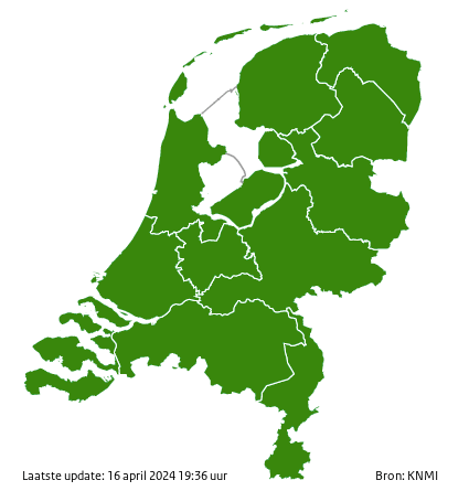
Code Oranjetwitter:KNMI twitterde op dinsdag 04-06-2019 om 14:55:34 Vanaf 18.00 #codeoranje in #Zeeland, #ZuidHolland en #NoordBrabant vanwege #onweersbuien. In de overige provincies geldt nog #codegeel. Houd onze weersverwachting in de gaten. #knmiwaarschuwing https://t.co/DXKDlnrpa7 reageer retweet
 Vanaf 18.00
Welke zeewind eigenlijk, ik zie niks op de windkaart wat uit zee komt.quote:
Recht zo die gaat, braaf zo die heen.

Zal straks wel weer ingetrokken worden.quote:Code Oranjetwitter:KNMI twitterde op dinsdag 04-06-2019 om 14:55:34 Vanaf 18.00 #codeoranje in #Zeeland, #ZuidHolland en #NoordBrabant vanwege #onweersbuien. In de overige provincies geldt nog #codegeel. Houd onze weersverwachting in de gaten. #knmiwaarschuwing https://t.co/DXKDlnrpa7 reageer retweet
[ afbeelding ]
Mwehquote:Op dinsdag 4 juni 2019 15:00 schreef Infection het volgende:
[..]
Zal straks wel weer ingetrokken worden.
Estofex gaat ook voor code 2 voor NL
Gewaarschuwd mens telt voor 2..quote:
[..]
Zal straks wel weer ingetrokken worden.
“Rather than love, than money, than fame, give me truth.”
Ik vroeg me een paar uur geleden al af waarom de KNMI niet met code oranje kwam.quote:Code Oranjetwitter:KNMI twitterde op dinsdag 04-06-2019 om 14:55:34 Vanaf 18.00 #codeoranje in #Zeeland, #ZuidHolland en #NoordBrabant vanwege #onweersbuien. In de overige provincies geldt nog #codegeel. Houd onze weersverwachting in de gaten. #knmiwaarschuwing https://t.co/DXKDlnrpa7 reageer retweet
[ afbeelding ]
Omegodquote:
We know this. The Chinese know that we know. But we make-believe that we don't know and the Chinese make-believe that they believe that we don't know, but know that we know. Everybody knows.
Hij liegt. Of ik sta op een plek die aerodynamisch dusdanig is dat de wind van de andere kant komt.quote:
[..]
Welke zeewind eigenlijk, ik zie niks op de windkaart wat uit zee komt.
Fake winds!quote:
[..]
Hij liegt. Of ik sta op een plek die aerodynamisch dusdanig is dat de wind van de andere kant komt.
Recht zo die gaat, braaf zo die heen.
Kreeg zelfs een pushmelding van de NOSquote:Code Oranjetwitter:KNMI twitterde op dinsdag 04-06-2019 om 14:55:34 Vanaf 18.00 #codeoranje in #Zeeland, #ZuidHolland en #NoordBrabant vanwege #onweersbuien. In de overige provincies geldt nog #codegeel. Houd onze weersverwachting in de gaten. #knmiwaarschuwing https://t.co/DXKDlnrpa7 reageer retweet
[ afbeelding ]
Trotse Twentenaar
Je zal maar in Limburg wonen op dr grens met Brabant, heb je lekker code geel iov oranje.  Maar eigenlijk raar dat codes per provincie gaan...
Per Gemeente is ook weer lastigquote:Op dinsdag 4 juni 2019 15:14 schreef Kapitein_Schavuit het volgende:
Je zal maar in Limburg wonen op dr grens met Brabant, heb je lekker code geel iov oranje.
Het is zeer bepalend..quote:
Heeft de temperatuur vandaag nog veel effect op hoe hevig het gaat uitpakken?
“Rather than love, than money, than fame, give me truth.”

Buienradar +48 uur zetten dan zie je rond 2 uur in de nacht van woensdag op donderdag ook een flinke bak ellende!
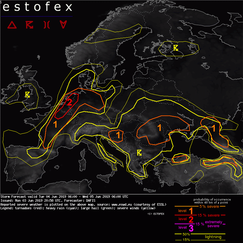
DISCUSSION
.... France, Belgium, the Netherlands, Luxembourg and Germany ....
The approaching trough from the west will be associated with the south-southeasterly flow near the surface, and the veering wind profiles that all available NWP models forecast, will create a dangerous environment for any thunderstorm that will develop. Convective initiation is expected first in Central - NE France after 15z where the PBL mixing ratio is expected to reach values up to 11 g/kg and steep mid-level lapse rates will build large values of CAPE. MLCAPE is forecast to exceed 1.5 kJ/kg inside the level-2 area where more than 15 m/s of 0-3km bulk shear will be available. Storms will be able to quickly form supercells, travelling long distances and producing large hail, severe wind gusts and tornadoes.
The latest outputs of regional models provide different solutions for the convective mode that should be anticipated. If discrete supercells form in NE France and Belgium then the main threat will be large (or very large) hail and tornadoes. If supercells form bow echoes then widespread severe wind gusts will be the main threat.
Given the low predictability of the storm-mode of the storms translating towards Belgium and the Netherlands, it is difficult to exclude any threat. Nevertheless, the high low-level shear of veering winds which create more than 100-150 m2/s2 SREH0-1km and low LCLs, even below 1000 m, mostly inside the level-2 area will increase the probability of tornadogenesis. Convection will become elevated during the night and storms should start weakening before midnight while entering the North Sea.

las het net ja, klinkt aardigquote:
DISCUSSION
.... France, Belgium, the Netherlands, Luxembourg and Germany ....
The approaching trough from the west will be associated with the south-southeasterly flow near the surface, and the veering wind profiles that all available NWP models forecast, will create a dangerous environment for any thunderstorm that will develop. Convective initiation is expected first in Central - NE France after 15z where the PBL mixing ratio is expected to reach values up to 11 g/kg and steep mid-level lapse rates will build large values of CAPE. MLCAPE is forecast to exceed 1.5 kJ/kg inside the level-2 area where more than 15 m/s of 0-3km bulk shear will be available. Storms will be able to quickly form supercells, travelling long distances and producing large hail, severe wind gusts and tornadoes.
The latest outputs of regional models provide different solutions for the convective mode that should be anticipated. If discrete supercells form in NE France and Belgium then the main threat will be large (or very large) hail and tornadoes. If supercells form bow echoes then widespread severe wind gusts will be the main threat.
Given the low predictability of the storm-mode of the storms translating towards Belgium and the Netherlands, it is difficult to exclude any threat. Nevertheless, the high low-level shear of veering winds which create more than 100-150 m2/s2 SREH0-1km and low LCLs, even below 1000 m, mostly inside the level-2 area will increase the probability of tornadogenesis. Convection will become elevated during the night and storms should start weakening before midnight while entering the North Sea.