WKN Weer, Klimaat en Natuurrampen
Lees alles over het onstuimige weer op onze planeet, volg orkanen en tornado's, zie hoe vulkanen uitbarsten en hoe Moeder Aarde beeft bij een aardbeving. Alles over de verwoestende kracht van onze planeet en tal van andere natuurverschijnselen.


twitter:severeweatherEU twitterde op maandag 20-05-2019 om 18:11:04 #TORNADO near Brand-Erbisdorf, Mittlesachsen, Germany this afternoon (16h local). May 20th. Report: Stormchasing Mittelsachsen https://t.co/BTmCQVWn74 reageer retweet


Komende dagen veel onweercellen, dus opletten!
In Baden-Badener Badeseen kann man Baden-Badener baden sehen.

twitter:WeatherSarov twitterde op woensdag 29-05-2019 om 18:02:04 #Tornado going through the capital of Belarus, Minsk an hour ago Video via- https://t.co/Xal5J4GYcJ https://t.co/4xhw2ptfXm reageer retweet

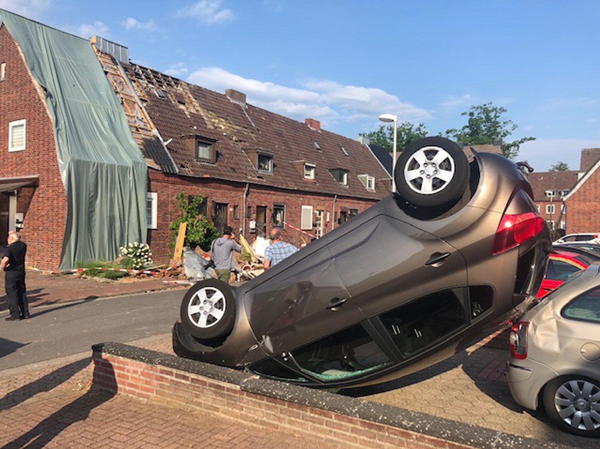
quote:Strong tornado hits Bocholt, Germany, causing significant damage
Authorities suspect a tornado hit the city of Bocholt, North Rhine-Westphalia, Germany late June 4, 2019, causing significant damage. Another round of severe thunderstorms is expected today.
Severe thunderstorms swept over parts of France, Benelux and Germany on June 4, bringing wind gusts in excess of 100 km/h (62 mph).
At this point, the worst affected appears to be the city of Bocholt where a suspected tornado touched down late June 4, overturning at least one car and damaging others, uprooting about 100 trees and damaging at least 9 houses. One person was slightly injured, the city spokesman said.
Severe Weather Europe meteorologists issued Moderate and Enhanced risks for ENE France, E Benelux into W Germany with threat for severe storms, capable of producing severe winds, large to very large hail, torrential rainfall with flash floods and tornadoes, valid June 6.
Widespread convective storms are expected within the strongly unstable and moderately sheared environment ahead of the front. Similar to a day before, scattered supercell storms initiation is likely during the mid-afternoon hours. A favorable LL shear and helicity should again develop threat for tornadic storms as well. Storms will likely merge into clusters with bowing segments towards the evening hours while spreading NNE-wards.
Authorities suspect a tornado hit the city of Bocholt, North Rhine-Westphalia, Germany late June 4, 2019, causing significant damage. Another round of severe thunderstorms is expected today.
Severe thunderstorms swept over parts of France, Benelux and Germany on June 4, bringing wind gusts in excess of 100 km/h (62 mph).
At this point, the worst affected appears to be the city of Bocholt where a suspected tornado touched down late June 4, overturning at least one car and damaging others, uprooting about 100 trees and damaging at least 9 houses. One person was slightly injured, the city spokesman said.
Although some experts and news portals are already reporting an EF-2 tornado, the German Weather Service (DWD) is still analyzing the data.
Strong and destructive tornadoes are not unusual in this part of Germany.
Another round of severe thunderstorms is expected to hit the region Wednesday night, June 5.
Severe Weather Europe meteorologists issued Moderate and Enhanced risks for ENE France, E Benelux into W Germany with threat for severe storms, capable of producing severe winds, large to very large hail, torrential rainfall with flash floods and tornadoes, valid June 6.
Widespread convective storms are expected within the strongly unstable and moderately sheared environment ahead of the front. Similar to a day before, scattered supercell storms initiation is likely during the mid-afternoon hours. A favorable LL shear and helicity should again develop threat for tornadic storms as well. Storms will likely merge into clusters with bowing segments towards the evening hours while spreading NNE-wards.
Update:
DWD meteorologist Andreas Friedrich said their analysis confirms a tornado hit the city of Bocholt. "It is the fifth tornado in Germany this year," he told CNN.
City authorities said it was a medium-strength tornado. A total of 9 houses were damaged and about 100 trees uprooted. Roof tiles were swirled around, windows and winter gardens damaged, and one car thrown 10 m (32.8 feet) in the air, they said.


Als t steeds warmer gaat worden komen hier dan ook steeds meer tornado's voor ?
"You can call me Susan if it makes you happy"

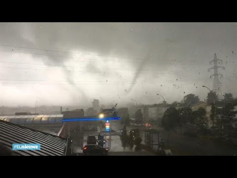
Luxemburg is vrijdagavond getroffen door een tornado, die veel krachtiger was dan de windhoos die over Amsterdam trok. Daken zijn van woningen gerukt en zeker honderd huizen zijn onbewoonbaar. 19 Mensen zijn gewond geraakt.
https://nos.nl/video/2297(...)boven-luxemburg.html
https://nos.nl/video/2297(...)boven-luxemburg.html
Dat lijkt mij wel. Al is het deze zomer vooral raak omdat de stroming meer zuidelijk is.quote:Op zaterdag 10 augustus 2019 15:15 schreef TLC het volgende:
Als t steeds warmer gaat worden komen hier dan ook steeds meer tornado's voor ?

hier video:quote:Op zaterdag 10 augustus 2019 18:04 schreef aloa het volgende:
Luxemburg is vrijdagavond getroffen door een tornado, die veel krachtiger was dan de windhoos die over Amsterdam trok. Daken zijn van woningen gerukt en zeker honderd huizen zijn onbewoonbaar. 19 Mensen zijn gewond geraakt.
https://nos.nl/video/2297(...)boven-luxemburg.html
https://5minutes.rtl.lu/actu/luxembourg/a/1388087.html
Holy shit dat zijn Amerikaanse toestanden.Daken worden gewoon compleet verscheurd. En dan ook nog flitsen van kortsluiting in die elektriciteitsmasten geeft het helemaal een apocalyptisch gevoel.
Opgeblazen gevoel of winderigheid? Zo opgelost met Rennie!
quote:Op zaterdag 10 augustus 2019 20:14 schreef Eyjafjallajoekull het volgende:
[..]
hier video:
https://5minutes.rtl.lu/actu/luxembourg/a/1388087.html
Holy shit dat zijn Amerikaanse toestanden.Daken worden gewoon compleet verscheurd. En dan ook nog flitsen van kortsluiting in die elektriciteitsmasten geeft het helemaal een apocalyptisch gevoel.
[ Bericht 1% gewijzigd door #ANONIEM op 10-08-2019 22:12:30 ]

 Op
Op 
Dronevideo van de schade in Luxemburg:
twitter:Meteos_ twitterde op zondag 11-08-2019 om 11:48:35 Survol depuis un #drone des dégâts à #Pétange #Luxembourg causés par la #Tornade , via https://t.co/tnGX9cT6Wo https://t.co/B4IeGb2IxZ reageer retweet
 Survol depuis un


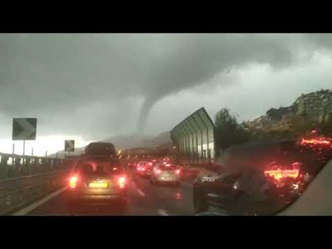
quote:Several injured as very destructive, possibly multivortex tornado hits Arles, France
Several people were injured after a destructive tornado hit the city of Arles, Bouches-du-Rhône, southern France on October 15, 2019. Damage suggests this was a multiple vortex tornado.
Heavy rain with winds up to 113 km/h (70 mph) started affecting the region late October 14, bringing heavy rain to Ardeche, Lozere and the Alpes-Maritimes.
In just 24 hours, Barnas in Piedmont Cevennes received 136 mm (5.35 inches) of rain. This is its two weeks of average rainfall.
The twister touched down in Arles' neighborhood of Pont-de-Crau around 04:50 LT on October 15, damaging cars and homes, downing trees and leaving the area without electricity.
About 150 homes were damaged or destroyed, including caravans and mobile homes in a nearby campsite. Some 60 people had to be temporarily relocated, an official at the Departmental operational fire and rescue center said.
Five people were injured, and one of them hospitalized.
According to Paul Marquis of The Weather of 13, the tornado traveled a distance of up to 6 km (3.7 miles) and was between 150 and 200 m (490 - 650 feet) wide, max up to 350 m (1 150 feet) in some places.
It was on the ground for 7 to 9 minutes and had winds of about 180 - 200 km/h (112 - 125 mph), making it an EF-2 category.
"After field investigation, it appears that it could have been multiple vortex tornado," Marquis said. "That is, there were not 1 but potentially 2 distinct cones at certain times. Indeed, within the main corridor of damage, we have seen differences. Not all this is proven at 100 %, but it's likely."


Zooooo... wowquote:
hier video:
https://5minutes.rtl.lu/actu/luxembourg/a/1388087.html
Holy shit dat zijn Amerikaanse toestanden.Daken worden gewoon compleet verscheurd. En dan ook nog flitsen van kortsluiting in die elektriciteitsmasten geeft het helemaal een apocalyptisch gevoel.
Zie het nu pas. Maar deze is wel écht heftig. Die zie je niet vaak op Europese bodem.
Eens kijken


quote:Tornado Greece
A short but devastating tornado struck a factory in Kalamata, southern Peloponnese, Greece around 13:05 LT on November 4, 2019. The destruction was caught by security cameras.
The owner of the Papadimitriou factory described the horrifying event, "It was a sudden loud noise and we saw the wind lifting heavy objects of 60 kg (132 lbs). We did not know what to do."
Sixty workers of the factory went in panic as the window glasses were shattered by powerful winds. The owner said the tornado only lasted for three to four minutes.
The company has expressed gratitude to everyone for their "love and support".
We feel very fortunate that although we were all in the factory at the time of the incident, we are all well," the owner said.
"The damage was, fortunately, only material. We’re sharing the video with you from the factory cameras, in order to make us all aware of the climate change."

twitter:JournalMeteo twitterde op zondag 26-04-2020 om 16:52:31 🔴 #Tornade dans le #PuyDeDôme ? Hier dans le sud du département, un entonnoir a été observé par un habitant sur la commune d'#AnzatLeLuguet lors d'un #orage.
Source : David Grampayre
#météo https://t.co/NCiUtjtbCu reageer retweet
 🔴
🔴 
twitter:niels2a twitterde op zondag 10-05-2020 om 16:09:58 Extra beeldmateriaal tornado regio Meer in de provincie Antwerpen! Doorgestuurd door Sophie Bogaerts via info@weerstationzoersel.be! @HLN_BE @Nieuwsblad_be @frankdeboosere @JillPeetersWX https://t.co/8Hfb9yeqaC reageer retweet
 Extra beeldmateriaal tornado regio Meer in de provincie Antwerpen! Doorgestuurd door Sophie Bogaerts via info@weerstationzoersel.be! @
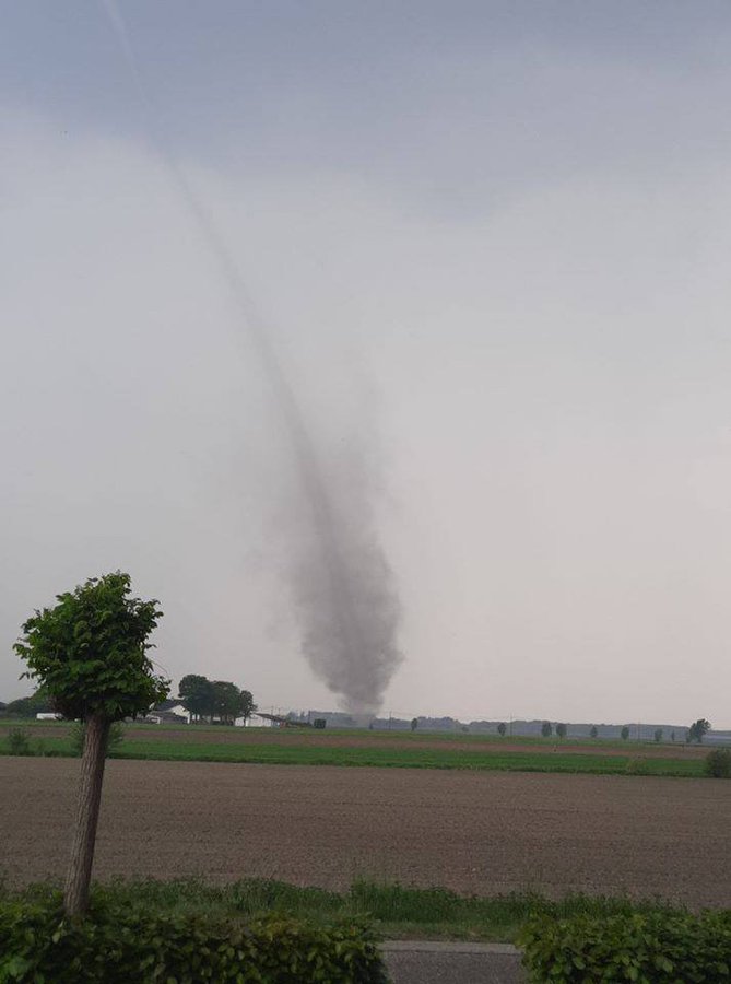
twitter:WeatherSarov1 twitterde op zaterdag 13-06-2020 om 15:18:06 Destructive #tornado in Makeevka, Donetsk oblast, Ukraine an hour ago. https://t.co/DpMsFu019z reageer retweet
 Destructive

|
|