WKN Weer, Klimaat en Natuurrampen
Lees alles over het onstuimige weer op onze planeet, volg orkanen en tornado's, zie hoe vulkanen uitbarsten en hoe Moeder Aarde beeft bij een aardbeving. Alles over de verwoestende kracht van onze planeet en tal van andere natuurverschijnselen.


Tropische Storm Joaquin... waar ga je heen en met welke kracht?
In de Atlantische Oceaan is het orkaanseizoen bijna in zijn laatste "officiële" maand aanbeland. Hoewel het tot op heden een 'rustig' seizoen is geweest met slechts één zware orkaan (Danny), één dodelijke orkaan (Erika) die Dominica trof en één met flinke schade op de Kaapverdische Eilanden (Fred) maakt het seizoen zich misschien op voor een verrassing.
Tropische Storm Joaquin ligt al een tijdje in het gebied waar hij zich nu bevindt, dat wil zeggen, ten noordoosten van de Bahama's. Daar lag de storm enigszins geblokkeerd door andere drukgebieden en de windschering zorgde onder andere voor genoeg tegengas om verder door te ontwikkelen. De restanten van ex-tropische storm Ida worden volgens mij door Joaquin benut om nu aan kracht te winnen.
Nu lijkt Joaquin dus eindelijk iets meer zijn zin te krijgen en lijkt langzaam koers te zetten naar het zuidwesten, richting de Bahama's. De modellen zijn het nog niet met elkaar ineens maar de kans bestaat dat de storm in zeer korte tijd enorm in kracht zal winnen. De verwachting is dan ook dat Joaquin binnen enkele uren de orkaanstatus gaat krijgen en mogelijk uitgroeit tot een categorie 3 orkaan.
Vermoedelijk zal Joaquin vrijdag het dichtst bij de Bahama's liggen alvorens hij de draai naar het noorden zal maken. Daar zal Joaquin opnieuw te maken krijgen met blokkades waardoor de 'normale' draai naar het noordoosten nog even op zich zal laten wachten. Wat er dan komt is afwachten. De koers lijkt op dit moment Virginia, maar het kan ook noordelijker en hij kan ook nog afdraaien, maar we herinneren ons volgens mij allemaal Sandy of Irene nog wel?
Radar
Meer weten over alle orkanen in de wereld?
WKN / Hurricane Season 2015 #1: Orkanen & cyclonen wereldwijd
[ Bericht 3% gewijzigd door Frutsel op 30-09-2015 09:22:52 ]

quote:Joaquin Intensifying; Potential Threat for Bahamas and U.S. Coast
Tropical Storm Joaquin is gaining strength as it moves slowly west-southwest toward the eastern Bahamas. Joaquin’s top sustained winds were upgraded from 50 to 65 mph in the 5:00 pm EDT Tuesday advisory from the National Hurricane Center (NHC). An Air Force hurricane-hunter aircraft found a central pressure of 990 millibars, a substantial drop from this morning. From aboard the aircraft, NOAA’s Stepped Frequency Microwave Radiometer detected surface winds on the order of 60-65 mph (see Figure 2) at around 2:00 pm EDT. Joaquin has struggled in the face of wind shear of 20-25 knots due to strong upper-level winds from the north-northwest; earlier Tuesday, the the low-level center of circulation exposed to view with all of the storm's heavy thunderstorms limited to the southeast side of the center. However, the thunderstorms maintained their vigor with the help of very warm waters and excellent outflow toward the south side of Joaquin, and on Tuesday afternoon an intense burst of thunderstorms developed atop the low-level center. With this consolidation, Joaquin has a much better chance to intensify further in the next 24 hours. Wind shear will be dropping below 20 knots by Wednesday and may dip below 15 knots for several days, lending more support to intensification. NHC now projects that Joaquin will be a hurricane by midday Wednesday.
Over the next couple of days, models agree that Joaquin will continue moving slowly toward the west-southwest, which will pose an increasing threat to the eastern Bahamas. The NHC may issue watches or warnings for the Bahamas later Tuesday night. Most of the 12Z Tuesday computer models stop Joaquin in its tracks just short of the Bahamas, but the usually reliable ECMWF model suggests a greater motion toward the southwest, indicating a potential threat to some of the eastern islands. During its slow westward trek, Joaquin will be passing over ocean temperatures near 30°C (86°F)--the warmest seen there since record keeping began in 1880. Oceanic heat content--the amount of energy stored in the upper 50 meters (160 feet) of the ocean--is another index of potential strengthening. Joaquin’s track should take it across the boundary into oceanic heat content values greater than 50 kilojoules per square centimeter by Wednesday. For tropical storms and Category 1 hurricanes, values of heat content greater than 50 kJ/cm2 have been associated with more rapid intensification rates, assuming that wind shear is less than 15 knots, mid-level relative humidity is greater than 50 percent, and SSTs are at least 28.5°C. Joaquin should meet most or all of these criteria over the next couple of days, which raises the possibility of robust intensification.
The long-range outlook for Joaquin
The 12Z Tuesday model runs did not clarify the unusually muddy waters surrounding the future track of Joaquin. By Friday, the eastern U.S. trough should begin to influence Joaquin and give it a northward component of motion, but the exact configuration of that trough--which will be critical to Joaquin’s track beyond Day 3--is still unclear. The models continue to show huge differences from run-to-run and with each other on just how this trough will develop and interact with Joaquin. The general tendency is for this trough to take on a negative tilt (a NW-to-SE configuration), with upper-level ridging becoming stronger off New England. All else being equal, this would tend to result in a more northwesterly path for Joaquin. Complicating the forecast is the presence of several areas of disturbed weather, including the remnants of Invest 99L (now over northern Florida); Invest 90L (incorporating the remnants of Tropical Storm Ida); and a frontal zone across the Northeast that will produce torrential rain (see below). All of these systems will pump large amounts of heat into the atmosphere through condensation, and this in turn will influence how the situation evolves.

quote:The model guidance from 12Z Tuesday shows two main possibilities by Days 5 and 6. The HWRF, GFDL, and UKMET models all depict a hurricane heading toward the mid-Atlantic by this weekend, tucking into the north side of the negatively tilted trough. In contrast, the ECMWF and GFS models show Joaquin heading out to the open Atlantic well before approaching the U.S. East Coast, as the trough pushes Joaquin eastward rather than pulling it into its northeast side. Various members of the ECMWF and GFS model ensembles have a wide range of solutions (see Figure 7 at right). Given the complexity of the factors involved, it is far too soon to put too much stock in any particular model solution. This is a good time to keep in mind that the width of the National Hurricane Center’s “cone of uncertainty” is based on average historical forecast errors from the last five years. In the case of Joaquin, the long-range uncertainty indicated by the models right now appears even larger than the cone’s historical database would suggest, which calls for even more caution than usual in focusing on any possible outcome. Data from the first dropsonde mission into Joaquin this afternoon by the NOAA Gulfstream-IV jet should make Tuesday night's 00Z suite of computer model forecasts more reliable than the Tuesday morning runs.
Regardless: heavy rain event coming to northern Appalachians and New England
Independent of Joaquin, an unusually intense heavy-rain event will be striking the northern Appalachians and New England over the next 2-3 days. Deep tropical moisture streaming northeastward from the Gulf of Mexico will lead to near-record high amounts of water vapor for the location and time of year. This moisture will intercept a preexisting frontal boundary, as rain-producing impulses move along the east side of the sprawling upper-level trough over the eastern U.S. The NOAA Storm Prediction Center is calling for widespread 3-5” rainfall from 00Z Wednesday to 00Z Friday from eastern New York across most of New England to southeastern Maine. Models are in fairly strong agreement that this heavy rain will develop, but there is some uncertainty on where the rains will be heaviest--in particular, the placement of the southwest-northeast stripe where training echoes could lead to particularly large amounts. Dry conditions have prevailed over the mid-Atlantic and New England over the last few weeks, moderate drought near the coast, so most locations could handle several inches of rain before general flooding became an issue. However, if intense rains fall in a short period over mountainous areas, some smaller creeks and streams could respond quickly and produce a localized flash flood threat. Urban areas from New York to Portland may also experience street flooding if the heaviest rains materialize there, as the drainage systems struggle to keep up. If Joaquin happens to move into New England early next week, there would be a much greater risk of widespread flooding.
Which track model should you trust?
According to the 2014 National Hurricane Center Forecast Verification Report, issued in March 2015, in 2014 we had two track models that at times out-performed the official NHC forecast, a feat that is tough to do. NOAA's HWRF model did slightly better than the NHC official forecast for 2-day and 3-day forecasts, while the UK Met Office's forecast did slightly better than NHC's 4-day and 5-day forecasts. Once again, the European Center (ECMWF) and GFS models excellent performers, but the GFDL model, a excellent performer in recent years, had substantially poorer forecasts than the other four models. The Canadian CMC model and simple BAMM model had accuracies comparable to the GFDL model. The European Center model and GFS models were virtually tied as the best performing models when averaged over the three-year period 2012 - 2014.


quote:Op woensdag 30 september 2015 10:45 schreef aloa het volgende:
EC laat hem wel afbuigen, maar de meeste modellen laten een landfall zien op de oostkust.

De hoofdrun laat hem nog richting Europa gaan.quote:
Kans is groot dat het de oostkust wordt...gezien dit kaartje.
Is die al niet achterhaald dan?quote:Op woensdag 30 september 2015 13:35 schreef aloa het volgende:
[..]
De hoofdrun laat hem nog richting Europa gaan.
Kans is groot dat het de oostkust wordt...gezien dit kaartje.
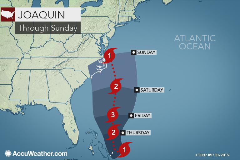
Onderstaand kaartje staat nu op de TWU site


Maar dat is gfs. EC laat hem volgens mij nog steeds richting Europa gaan.quote:Op woensdag 30 september 2015 13:36 schreef Frutsel het volgende:
[..]
Is die al niet achterhaald dan?
Onderstaand kaartje staat nu op de TWU site
[ afbeelding ]
http://www.weatheronline.(...)&WMO=&ARCHIV=0&RES=0


De Bahama's eilanden gaan het zwaar krijgen. Joaquin trekt nog iets meer naar het zuiden, waardoor ze ook met de orkaan wind, hoge golven en overstromingen te maken krijgen.
El Nino zorgt er een klein beetje voor dat het orkaanseizoen vrij 'rustig' is... in tegenstelling tot de westkust van de VS daar komen veel meer (zwaardere) stormen voor dit jaar maar die bereiken niet vaak land.quote:
Zou El Nino dit niet moeten voorkomen?
Wel komen in het jaar NA een el-nino vaak zwaardere stormen voor in de Atlantische regio dus... ben benieuwd naar de seizoenen van 2016 en 2017.
Daarom vind ik het ook zo apart. Als het eenmaal afbuigt dan is die storm ook klaar. Met een El Nino zou een storm niet zo noordelijk moeten komen...quote:
[..]
El Nino zorgt er een klein beetje voor dat het orkaanseizoen vrij 'rustig' is... in tegenstelling tot de westkust van de VS daar komen veel meer (zwaardere) stormen voor dit jaar maar die bereiken niet vaak land.
Wel komen in het jaar NA een el-nino vaak zwaardere stormen voor in de Atlantische regio dus... ben benieuwd naar de seizoenen van 2016 en 2017.
100.000 katjes
Fuck the EBU!
Fuck the EBU!
Check de heatmap eensquote:
[..]
Daarom vind ik het ook zo apart. Als het eenmaal afbuigt dan is die storm ook klaar. Met een El Nino zou een storm niet zo noordelijk moeten komen...

Bizar hoge temperaturen daar voor dit jaar. Regio is veel warmer dan gemiddeld. Dus de voedingsbodem is er wel
Dat verklaart wel een beetje waarom ie niet stukgeblazen wordt iig. Alleen blijf ik het een apart traject vinden.quote:
[..]
Check de heatmap eens
[ afbeelding ]
Bizar hoge temperaturen daar voor dit jaar. Regio is veel warmer dan gemiddeld. Dus de voedingsbodem is er wel
100.000 katjes
Fuck the EBU!
Fuck the EBU!
Het aparte aan de koers is de afbuiging naar de VS. In de meeste gevallen trekken ze met een boog langs de oostkust richting Europa, maar deze doet hetzelfde als Sandy deed in 2012...quote:
[..]
Dat verklaart wel een beetje waarom ie niet stukgeblazen wordt iig. Alleen blijf ik het een apart traject vinden.
|
|