WKN Weer, Klimaat en Natuurrampen
Lees alles over het onstuimige weer op onze planeet, volg orkanen en tornado's, zie hoe vulkanen uitbarsten en hoe Moeder Aarde beeft bij een aardbeving. Alles over de verwoestende kracht van onze planeet en tal van andere natuurverschijnselen.


Cycloon Nathan nadert Queensland
Nathan draait al enige tijd rond voor de kust van Australië. Een aantal dagen geleden lag het systeem al dicht bij de kust, waarna deze richting het oosten trok.
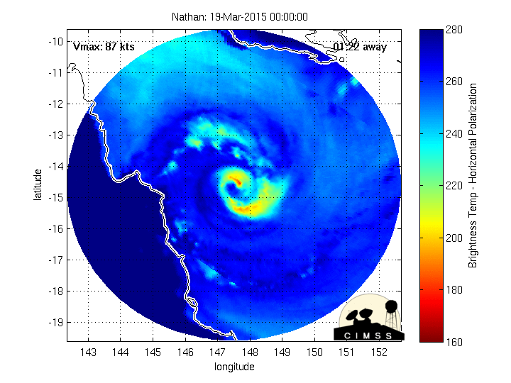
Nathan is vervolgens weer omgekeerd en ligt nu op ramkoers met Australië.
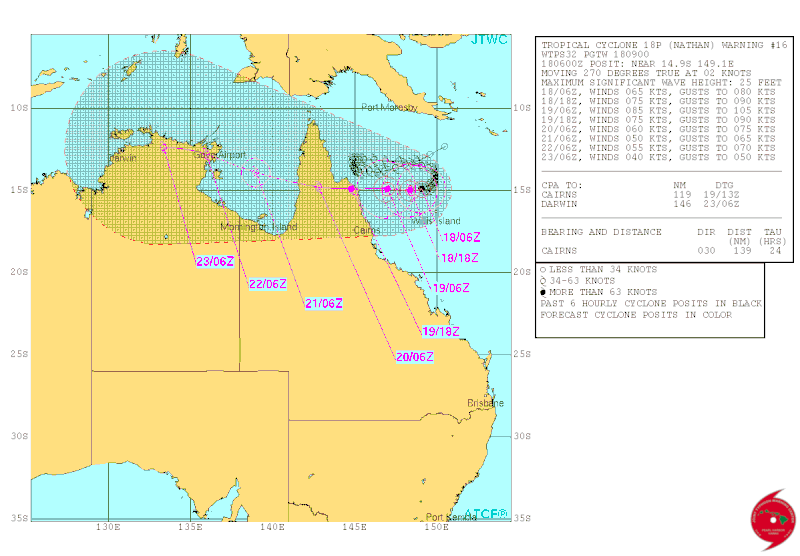
Volgens de voorspelling van JTWC gaat Nathan nog verder toenemen in kracht tot een categorie 2. Op dit moment is de hoogste windsnelheid 120 km/u met windstoten tot 144 km.

Nathan draait al enige tijd rond voor de kust van Australië. Een aantal dagen geleden lag het systeem al dicht bij de kust, waarna deze richting het oosten trok.
Nathan is vervolgens weer omgekeerd en ligt nu op ramkoers met Australië.
Volgens de voorspelling van JTWC gaat Nathan nog verder toenemen in kracht tot een categorie 2. Op dit moment is de hoogste windsnelheid 120 km/u met windstoten tot 144 km.
quote:Far north Queensland residents are busy making disaster preparations as Cyclone Nathan has been upgraded to a category three system ahead of its potentially destructive return.
In a major warning, forecasters have predicted the cyclone could become a category-four storm by the time it makes landfall early Friday - a week after it threatened to hit the far north coast before doubling back to the east.
Cooktown is again in the firing line with current modelling showing Nathan will make landfall in the vicinity of the town, north of Cairns, on Friday morning.
But the Queensland Bureau of Meteorology says this could change and communities from Coen, north of Cooktown, to Cardwell, south of Cairns, are on alert.
Cyclone Nathan was upgraded to a category two at 11am AEST, and then a category three six hours later, and is expected to intensify further as it approaches the north coast.
Residents are being warned to stock up on food, water, medications and to draw out cash in preparation for power outages.
The shire's disaster management group met on Wednesday and will reconvene on Thursday.
Mayor Julia Leu said sandbags were being made available to guard against flooding.
"We know we've got to be as prepared as possible. Cyclones are so unpredictable," she told AAP.
They have also be advised to pack emergency kits, including first aid equipment, important documents, valuables and sleeping gear.
Queensland Fire and Emergency Services (QFES) far northern regional director Wayne Coutts says residents have a limited window of opportunity to batten down the hatches.
"Get your property ready by bringing loose outdoor items indoors and securing all items, which can't be brought in, such as swing sets and trampolines," he said.
He advised windows to be taped in a criss-crossing fashion with strong packing tape.
While this may not prevent windows from shattering, it's expected to hold the broken glass in place.
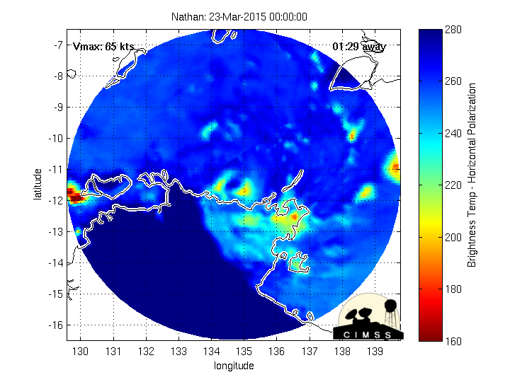
Cyclone Nathan generated torrential rain and destructive winds when it swept pass the far north coast last week before heading out to sea only to do a u-turn.
http://www.9news.com.au/n(...)to-hit-far-north-qld

hahaha...quote:Op woensdag 18 maart 2015 19:41 schreef Metalfrost het volgende:
De TT'Alsjeblieft, Queensland, hier heb je wat wind'


Kern ligt weer dichter bij land. Inmiddels valt er al tussen de 10 - 25 mm regen per uur aan de kust.

Lijkt erop dat Nathan landfall heeft gemaakt.
[ Bericht 7% gewijzigd door #ANONIEM op 19-03-2015 19:14:45 ]
[ Bericht 7% gewijzigd door #ANONIEM op 19-03-2015 19:14:45 ]


|
|