Boven de golf van Carpantaria is een tropisch systeem ontstaan die de naam LAM heeft gekregen. Deze cycloon is nu nog een tropische storm, maar zal waarschijnlijk gaan toenemen tot een categorie 3 orkaan met een windsnelheid die boven de 200 km zal uitkomen.
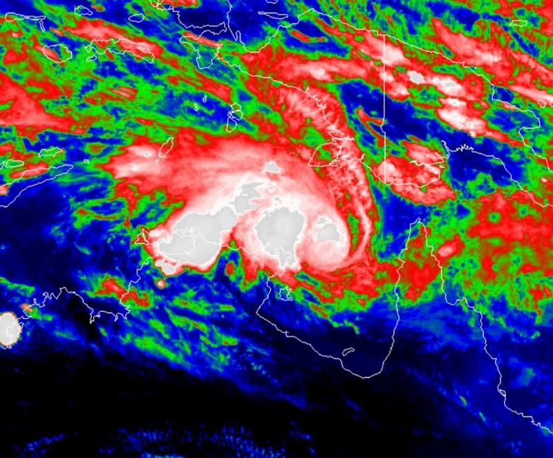
De voorspelling is dat LAM langzaam richting de kust van Australië zal trekken. Het zeewater van de golf is bijzonder warm (>31 graden celcius). waardoor er een zeer grote hoeveelheid neerslag kan gaan vallen en de kracht nog verder kan gaan toenemen.

Cyclonen komen vaker voor in Australie. Soms met verwoestende gevolgen.
Tijdens de kerstdagen van 1974 trok de cycloon Tracy over de stad Darwin. Dit kostte 49 mensen het leven terwijl ongeveer 70% van de bebouwing werd verwoest. Sindsdien is de stad opgebouwd tot een moderne tropische stad. De stad is genoemd naar Charles Darwin.
@wikipedia
quote:The latest advice released by the Bureau of Meteorology at 5:01pm issued a cyclone warning for Maningrida to Cape Shield, including Nhulunbuy.
That means those areas can expect gale force winds within 24 hours.
A cyclone watch, which means gale force winds could be felt within 48 hours but not before 24 hours, was issued for Goulburn Island to Maningrida and Cape Shield to Port Roper, including Groote Eylandt.
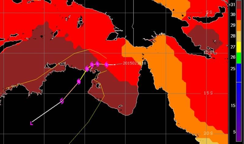
The latest track map shows Tropical Cyclone Lam heading further west before turning south, compared to previous maps.
It shows the cyclone could make landfall near the Wessel group of island of the northern coast of Arnhem Land.
The advice said Tropical Cyclone Lam was estimated to be 230 kilometres east north-east of Nhulunbuy and 365 kilometres north-east of Alyangula.
Nhulunbuy is almost 700 kilometres east of Darwin on the remote north eastern tip of Arnhem Land.
Alyangula is the largest community of Groote Eylandt, which is in the Gulf of Carpentaria off the NT coast and south of Nhulunbuy.
'Communities should now be prepared': emergency services chief
NT Emergency Services director Andrew Warton said all affected communities should be prepared.
"By now in all the affected communities you should have a cyclone kit prepared, you should have a cyclone emergency plan, you should have discussed with your family and your friends what you will do if this cyclone affects your community," he said.
"It is absolutely essential at this point in time to monitor your radio and to use Secure NT as the sole source of truth for information that is being made available during the event."
He also said people should not head to emergency shelters until they had been told by officials to do so.
Chief Minister Adam Giles announced several schools in the region would be closed tomorrow.
"I've directed that the schools of Yirrkala School, Yirrkala School, Nhulunbuy High School, Nhulunbuy Primary School, Nhulunbuy Christian School and Baniyala Garrangali School are all to remain closed for tomorrow," he said.
Mr Giles signalled the Government was still taking advice on whether other schools would be closed and parents would be told as soon as possible whether more schools would close.
All non-key public servants in the affected area have also been told to stay home, Mr Giles said.
The bureau also had a flood watch out for areas of the Gulf coast, Mr Smith said.
"Obviously as the cyclone moves closer to the Gove Peninsula we would expect much heavier falls around that system," he said.
"We have a flood watch current for Arnhem Land and also the Gulf country coast.
"Certainly later in the week and towards to the weekend we could see some significant falls in catchments like the Roper and the McArthur where we could see some significant stream rises from the big rivers."
http://www.abc.net.au/new(...)ategory-four/6132034

Je zou haast denken dat ze er nu drie krijgenquote:

Ze verwachten dat Marcia nog sterker wordt
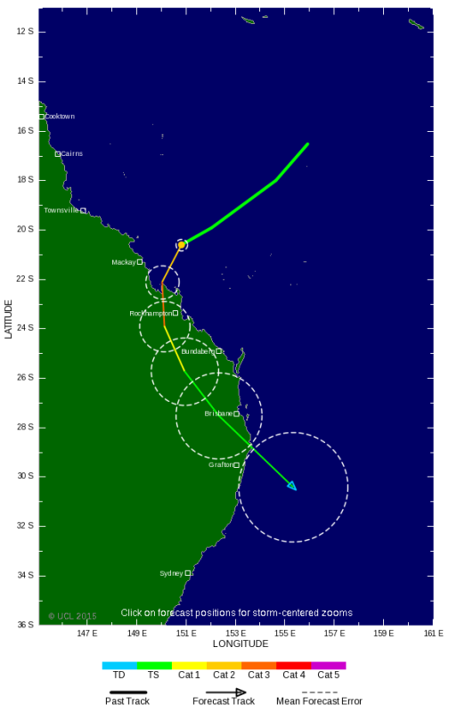
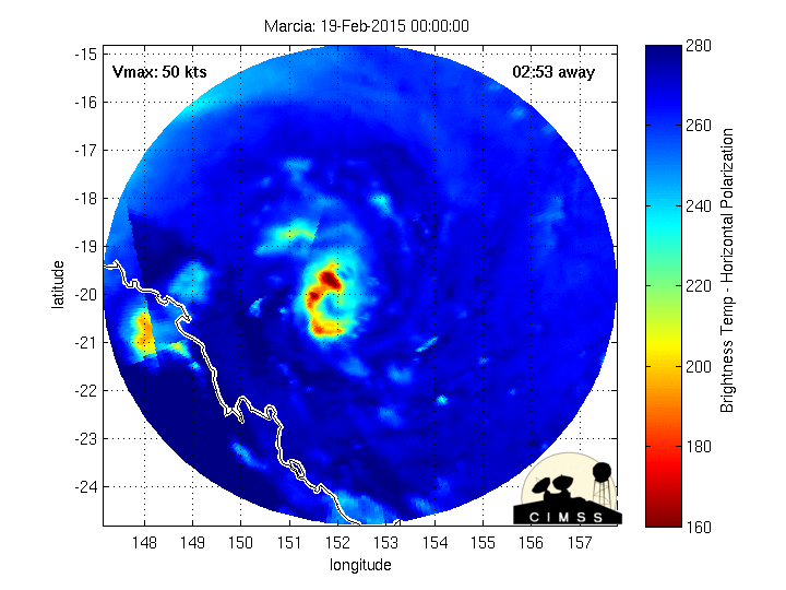
quote:Tropical Cyclone Marcia: Storm due to hit Queensland as category five system
Tropical Cyclone Marcia is continuing to rapidly intensify and is due to make landfall as a category five system on Friday morning.
The category four cyclone looms about 150 kilometres off the coast and is due to hit land between Mackay and Gladstone about 8:00am.
A very destructive central core, spanning less than 100 kilometres, would generate gusts up to 295 kilometres an hour, the Bureau of Meteorology warned.
Premier Annastacia Palaszczuk hoped the cyclone would cross in a remote area.
"That is the indication at the moment, but anything can change here," she said.
It is on track to hit St Lawrence, which has a few hundred locals, as a category five and is expected to travel south over land reaching Maoura and Biloela as a category one system on Friday night.
A cyclone watch has been issued for areas between Bundaberg and Double Island Point, extending inland to include Mundubbera, Gayndah, and Murgon.
For live updates on Queensland's weather emergency, go to our blog.
Destructive winds are expected to develop about coastal and island communities between Mackay and Burnett Heads tonight.
Gales are now beginning to occur about coastal and island communities between Mackay and Double Island Point, and are expected to extend north to Bowen later this evening and inland to areas including Blackwater, Moura, Biloela, and Monto overnight and Friday.
Isaac Regional Shire Mayor Anne Baker said the cyclone was due to make landfall near St Lawrence, which was in her area.
She said an evacuation centre had been set up at Sarina.
"We are strongly advising coastal residents to self evacuate," she told 612 ABC Brisbane.
"It has been 25 years since we have seen anything of this calibre."
Top.
Brisbane heeft wel interessant weer inderdaadquote:Op donderdag 19 februari 2015 12:14 schreef GotenSSJ het volgende:
Dit is wel top man. Ik verhuis in September naar Brisbane, vervolgens hebben we de ergste storm in 40 jaar hier in November en nu de ergste cycloon in 25 jaar blijkbaar, als dat laatste nieuwsartikel klopt.
Top.
Kan flink tekeer gaan daar.
Intensity: category 4, sustained winds near the centre of 195 kilometres per hour with wind gusts to 270 kilometres per hour.
NOS komt er nu pas mee
Darwin: The "destructive core" of Cyclone Lam has begun lashing parts of the Northern Territory coast.
The category four storm is unleashing wind gusts up to 260km/h and was 20 kilometres west-northwest of Galiwinku on Elcho Island late on Thursday night.
Lam is forecast to maintain its intensity when it makes landfall between Elcho Island and Milingimbi about 4am (CST) on Friday.
"The very destructive core of severe Tropical Cyclone Lam is continuing to track southwest and is now impacting the coast near Elcho Island," the Bureau of Meteorology said in an update.
The bureau also warned: "Conditions at Elcho Island, Gapuwiyak, Ramingining and Milingimbi are at a dangerous level - remain in shelter now".
It is expected to slowly cross the coast and then weaken on Friday as it moves over Arnhem Land.
Wind gusts of more than 230km/h will continue over the southern Wessel Islands and the mainland coast near Elcho Island before impacting Milingimbi and surrounding areas into early Friday.
Strong winds will impact coastal areas between Maningrida and Nhulunbuy before battering inland areas on Friday.
The weather bureau is warning coastal residents between Milingimbi and Nhulunbuy, including Elcho Island, of a very dangerous storm tide which may cause flooding as the cyclone approaches.
Heavy rain may cause flooding of some low-lying areas in the northeast of the Top End into Friday.
Meanwhile, more than 400 residents of Goulburn Island, one of the most remote places in Australia, were moved to safety in Darwin earlier on Thursday.
Located off the north coast of the Top End, all residents of its Warruwi community were evacuated.
Power and water supply has already been cut off in Galiwinku, said local teacher Josh Keating.
"Trees have started to go down; it is starting to get a bit hairy," Mr Keating said.
"Power and water is a concern, as we don't know how long it will be before we get it back. It could be a matter of days, or it could be a week."
Of the community's 3000 people, 400 were protected in two main shelters.
Acting NT Police Commissioner Reece Kershaw earlier estimated that four to five thousand people were potentially in the path of the storm, in very remote communities.
Seas under the cyclone are exceeding eight metres, said Ashley Patterson, senior forecaster with the Bureau of Meteorology
[ Bericht 2% gewijzigd door #ANONIEM op 19-02-2015 15:57:24 ]
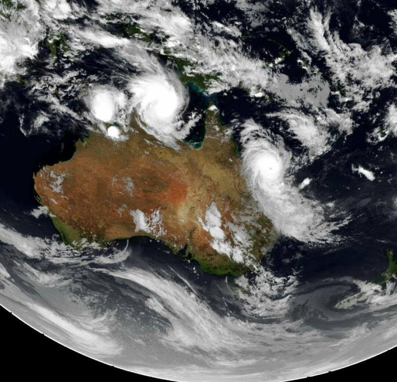
Een zware orkaan raast over Australië. Marcia kwam in Queensland aan land als een categorie-5 storm. Dat is de zwaarste categorie, met windstoten tot 295 kilometer per uur. Inmiddels is hij in kracht iets afgenomen.
De 16.000 inwoners van de kustplaats Yeppoon waren de eersten die de verwoestende kracht van Marcia voelden. Op veel plaatsen vielen bomen en elektriciteitsmasten om. Velen in de regio hebben geen elektriciteit meer.
"Ze bouwden vroeger huizen die alles moesten kunnen doorstaan. Laten we hopen dat ons huis het nog een tijdje volhoudt", zegt John McGrath, die in zijn authentieke Queenslander huis de storm goed hoopt te doorstaan.
Vloedgolven
Bij een storm van de categorie 5 wordt grootschalige schade verwacht. De autoriteiten manen de bevolking om binnen te blijven, vanwege het gevaar van rondvliegend puin. Er zijn verschillende opvangcentra geopend en alle scholen zijn gesloten.
De storm gaat gepaard met hoge vloedgolven en veel neerslag. Daardoor neemt het risico op overstromingen toe. De storm buigt langzaam af richting Brisbane en zal geleidelijk in kracht afnemen.
Tweede orkaan
Een tweede orkaan, Lam, is inmiddels afgewaardeerd naar categorie 2. De storm is aan land gekomen in het dunbevolkte Northern Territory. Verschillende Aboriginalgemeenschappen zijn geëvacueerd en in schuilkelders ondergebracht. De verwachting is dat de schade door Lam beperkt blijft.
http://nos.nl/artikel/202(...)osten-australie.html
Wat een slechte berichtgeving..