WKN Weer, Klimaat en Natuurrampen
Lees alles over het onstuimige weer op onze planeet, volg orkanen en tornado's, zie hoe vulkanen uitbarsten en hoe Moeder Aarde beeft bij een aardbeving. Alles over de verwoestende kracht van onze planeet en tal van andere natuurverschijnselen.


nooit geweten dat Napels in IJsland lagquote:Op woensdag 21 december 2016 07:00 schreef Basp1 het volgende:
Misschien in 2020 een grote uitbarsting bij Napels.
http://www.volkskrant.nl/(...)0-ontwaken~a4437473/
(╯°□°)╯︵ ┻━┻ ლ(ಠ益ಠლ) ٩͡๏̯͡๏۶ ಠ_ಠ ᕕ( ᐛ )ᕗ

Er is een topic over de Campi Flegrei...quote:
Misschien in 2020 een grote uitbarsting bij Napels.
http://www.volkskrant.nl/(...)0-ontwaken~a4437473/
WKN / Vesuvius heeft grote broer: Supervulkaan kan leven in Europa bedreigen
(heb het ff daarin gegooid
en anders kan dat ook hierin:
WKN / [Vulkanen] The ring of fire #7: Gaia's hete inborst
maar tis ook best een eigen topic waardig
alleen hier gaat het over de vulkanen in IJsland
[ Bericht 4% gewijzigd door Frutsel op 21-12-2016 08:55:58 ]
Sorry ik dacht even dat dit het centrale vulkanen topic was.quote:
[..]
nooit geweten dat Napels in IJsland lag
zo'n vermoeden had ik alquote:
[..]
Sorry ik dacht even dat dit het centrale vulkanen topic was.
(╯°□°)╯︵ ┻━┻ ლ(ಠ益ಠლ) ٩͡๏̯͡๏۶ ಠ_ಠ ᕕ( ᐛ )ᕗ
Ik ben nu in IJsland op familiebezoek voor twee weken.
Misschien dat we nog gaan kijken bij een vulkaan in de buurt als we tijd hebben.
Misschien dat we nog gaan kijken bij een vulkaan in de buurt als we tijd hebben.
"One cries because one is sad. For example, I cry because others are stupid, and that makes me sad."
Gaafquote:
Ik ben nu in IJsland op familiebezoek voor twee weken.
Misschien dat we nog gaan kijken bij een vulkaan in de buurt als we tijd hebben.
Welke vulkaan gaat het worden?
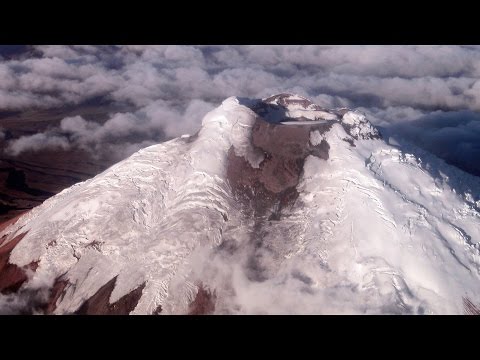
quote:Earthquake in Iceland's Katla volcano
An earthquake of magnitude 3,5 took place in the Katla volcano in South Iceland at 7:09 this morning. The earthquake originated in the west side of the volcano’s caldera, underneath the Mýrdalsjökull glacier. Katla is one of Iceland’s largest and active volcanoes with over twenty eruptions documented since the year 930.
From June to September of last year, the volcano was hit with a series of seismic tremors and high level of unrest. For a few days at the end of September and early October, Katla was raised to “yellow alert” by the Icelandic Met Office, roads near the volcano were closed due to eruption warning, and the volcano was under 24 hour watch by the Met Office.
On September 30th over 200 earthquakes were detected in Katla over a period of 24 hours, the greatest frequency of earthquakes in the volcano since 2011.
quote:Strong 4.2 quake in Katla caldera
Icelandic Met Office has detected a strong and shallow M4.2 earthquake in the center of Katla caldera on January 26, 2017. The quake was followed by M3.0 and a series of smaller earthquakes. In total, 28 earthquakes were registered under Katla since late Wednesday, January 25.
The quakes follow a wave of increased activity in the past couple of weeks. On Monday and Tuesday, January 23 and 24, the volcano registered several large earthquakes, following a wave of activity at the beginning of January, IcelandMag reported.
On Monday, January 23, IMO registered two M3+ earthquakes (M3.0 and M3.3) in the eastern part of the caldera, followed by a large swarm of smaller quakes. This activity was followed by a M3.1 earthquake on January 24.
According to the IMO, the volcano is under close supervision and there are no signs of increased volcanic activity.
On September 29, 2016, an intense seismic swarm started under the volcano and intensified on September 30 with several M3+ earthquakes. The Aviation Color Code was raised to Yellow, the second highest level on a four-color scale. On October 3, IMO stated that the seismic swarm was the largest one in decades, though it appeared to be over.
20 eruptions have been documented at Katla between 930 and 1918, at intervals of 13 to 95 years. Since the last eruption took place in 1918, Katla is long overdue for an eruption.
This volcano is known for strong eruptions, with Volcanic Explosivity Index mostly between 4 and 6 (on a scale of 0 to 8).
Its eruption could pose a threat to civilians due to glacial flooding and significant ash generation.

http://www.iflscience.com(...)anoes-priming-erupt/
quote:Four Of Iceland's Volcanoes Are Priming To Erupt
As we all know, Iceland is a profoundly volcanic place with a variety of eruption styles – from spewing out a little or a lot of lava, to exploding so violently that Europe gets blanketed in ash.
Well, as reported by the Iceland Monitor, the nation’s soothsaying geophysicist Páll Einarsson claims that four of the country’s angry mountains are exhibiting pre-eruptive conditions. Apart from that, however, little information has been given.
The volcanoes in question are Katla, Hekla, Bárðarbunga, and Grímsvötn. With no data or references given in the post, we decided to do a little digging ourselves.
So what of Katla? Well, it’s a rather sizable volcano that has indeed been showing signs of restlessness recently, with tremors hitting around the 4.6M mark. These quakes are possibly indications of magma ascending upwards through the crust and causing it to violently fracture, but as of yet, there’s no definitive proof of this.
Katla occasionally lets off some steam through minor lava flows, but there hasn’t been a major eruption for several decades. Its average recurrence rate for something significant and potentially dangerous is once every 50 years. The last notable event back in 2011 produced some impressive streams of lava, but it was not enough to smash through the Mýrdalsjökull glacier capping it at the surface.
When it inevitably does, a massive ash plume – akin to the one produced by the Eyjafjallajökull in 2010 – will be generated, and North Europe’s airspace will be immediately shut down. According to a recent study, however, such an epic plume only appears once every 44 years, so we’ve probably got some time before that happens again.
It’s worth noting, however, that the 2011 event produced a “jökulhlaup”, a flash flood caused by part of the glacier melting. It was powerful enough to sweep away a major bridge – although luckily without any accompanying deaths.


Dat was blijkbaar toch in de Bardarbunga vulkaan.quote:
https://twitter.com/jonfr500/status/830717606621483010
Meerdere bevingenen +2 waarvan de hoogste 3.6
[ Bericht 0% gewijzigd door #ANONIEM op 12-02-2017 17:15:22 ]
quote:Earthquake swarm under Bardarbunga volcano, Iceland
An earthquake swarm started under Bardarbunga volcano, Iceland during the early morning hours of Wednesday, March 1, 2017. The swarm started at 08:57 with M4.1 (the strongest) and ended at 10:24 UTC. There were no additional earthquakes registered over the next 24 hours.
Bryndís Ýr Gísladóttir, a specialist in natural hazards with the Icelandic Met Office told media that five powerful earthquakes were detected in the caldera of Bardarbunga volcano on March 1, 2017.
The sequence started with M4.1 at 08:57 UTC at a very shallow depth of 0.1 km (0.06 miles) and continued with M2.3 at a depth of 2.3 km (1.5 miles) within the first minute. In total, there were 5 earthquakes with magnitude above 3.0.
Bryndís insists that there are currently no signs of magma unrest in the area and that earthquakes have been common since the volcanic eruption in Bárðabunga ended in 2015. A similar incident happened in January 2017.
Geological summary
The large central volcano of Bárðarbunga lies beneath the NW part of the Vatnajökull icecap, NW of Grímsvötn volcano, and contains a subglacial 700-m-deep caldera. Related fissure systems include the Veidivötn and Trollagigar fissures, which extend about 100 km SW to near Torfajökull volcano and 50 km NE to near Askja volcano, respectively.
Voluminous fissure eruptions, including one at Thjorsarhraun, which produced the largest known Holocene lava flow on Earth with a volume of more than 21 cu km, have occurred throughout the Holocene into historical time from the Veidivötn fissure system.
The last major eruption of Veidivötn, in 1477, also produced a large tephra deposit. The subglacial Loki-Fögrufjöll volcanic system to the SW is also part of the Bárðarbunga volcanic system and contains two subglacial ridges extending from the largely subglacial Hamarinn central volcano; the Loki ridge trends to the NE and the Fögrufjöll ridge to the SW. Jökulhlaups (glacier-outburst floods) from eruptions at Bárðarbunga potentially affect drainages in all directions

quote:Strong earthquake swarm in Bárðarbunga
During the night of 08-March-2017 a strong earthquake swarm took place in Bárðarbunga volcano. Largest earthquake in this swarm had the magnitude of 4,1 and the second largest earthquake swarm had the magnitude of 3,9. Other earthquakes in this swarm where smaller in magnitude.
Earthquake activity happens in Bárðarbunga volcano mainly due to magma being injected into the main volcano at depth. This goes into magma chambers somewhere in the volcano, current data suggests that the magma chamber that erupted in in August 2014 to February 2015 is currently inflating. The rate of this type of earthquake activity has gone down in Bárðarbunga volcano, this used to be a weekly activity but now only happens every 2 to 4 weeks at the moment. This slowdown in activity is likely to continue if nothing else happens (new eruption or dyke activity).
quote:Bárðarbunga volcano joins Hekla: 3.2 magnitude quake and earthquake swarm over weekend
The 4.5 magnitude earthquake west of volcano Hekla on Saturday was followed up by a 3.2 magnitude quake in the Bárðarbunga caldera later the same evening. The quake, which had its epicenter at a depth of 4.3 km (2.7 miles) in the N.E. part of the caldera was followed by a swarm of smaller quakes, including two 2.1 and 2.5 magnitude quakes, in the N.E. and S.E parts of the caldera.
What is going on?
It is unlikely the two episodes are connected. The earthquakes in Bárðarbunga are caused by magma thrusting its way from the mantle to the magma chambers of the volcano, refilling it after the 2014-15 Holuhraun eruption. Bárðarbunga is preparing for continued volcanic activity.
Volcanic zones and seismic rift zones
The Saturday quake west of Hekla took place in the South Iceland Seismic Zone, a transform fault between offset sections of the Mid-Atlantic Ridge which runs through Iceland. The zone is made up of a series of fracture faults which run from SW to NE. The zone extends from the volcano Hengill, the easternmost part of the Reykjanes volcanic zone to Hekla, which is the westernmost volcano in the East Volcanic Zone.
The massive "South Iceland Quake"
There are no active volcanoes in the South Iceland Seismic Zone, but it is extremely active. The area sits between the two volcanic zones, and is constantly being pulled in two different directions, causing tension to build up in the crust which is then periodically released in earthquakes.
The zone has been the source of the most powerful earthquakes in Iceland, as the most powerful earthquake which has taken place in Iceland since the country was settled took place in the Southern Seismic Zone.
Read more: All of Iceland‘s major volcanoes showing unusually high levels of activity
On 1784 a massive earthquake, which is believed to have been 7.1 magnitude, shook all of southern Iceland, causing widespread damage to farmhouses.
The second largest earthquake, and the largest to be measured with modern equipment, was detected in 1912. This quake was 7.0 on the Richter scale. Both quakes took place close to Saturday's tremor. Quakes of this magnitude are believed to hit once every 100-150 years, and could cause significant damage. Locals in South Iceland are still waiting for the "big one".
quote:Earthquakes and tremors continue around notorious volcano Katla
The past few days have seen a swarm of tremors around Katla volcano, but yesterday they reached over a 3 in magnitude or up to 3.6. According to reports quakes aren’t always signs of looming eruptions although the seismic activity has been frequent of late. The Icelandic Met Office is closely monitoring the volcano and surrounding area.
Katla is a large subglacial volcano in southern Iceland. It’s been dormant under the Mydalsjokull glacier for almost 100 years, but it’s considered a very active volcano with twenty documented eruptions between 930 and 1918, with intervals of 13–95 years.
Katla hasn’t erupted forcefully since 1918, although there may have been small eruptions under the icecap that didn’t break the ice, including ones in 1955, 1999, and 2011. Prior eruptions have measured with a Volcanic Explosively Index of between VEI-4 and VEI-6 on a scale of 0 to 8. In comparison, the infamous 2010 Eyjafjallajokull eruption had a VEI-4. The last major eruption started on 12 October 1918 and lasted for 24 days. It was likely a VEI-5 level eruption.
Katla’s present dormancy is among the longest in known history and many theorize that the current seismic activity is a sure sign of a pending eruption although the Icelandic Met Office assures that there are no definite tell tale signs of a looming eruption.
Volcanologist Jon Friman speculates that the depth of some of the quakes indicates that fresh magma is making its way upward in the magma chamber. One of the quakes was measure on 14.4 km depth and Friman takes that as an indicator of the mountain getting ready to erupt, quakes on such a depth are caused by magma movement rather than movement in the earth’s crust. The greatest depth measured in this series of quakes is 15.5 km and the one closest to the surface was 0.1 km down.
The string of tremors can be observed online with updates of 60 seconds in 3D images in a program developed and made by Baering Gunnar Steinthorsson. The images display the size and depth of the quakes almost in real time. The colour coding for the age of the quakes is the same as the Icelandic Met Office uses, the newest are red, then orange, yellow, blue and the oldest ones are dark blue. The display is based on data from the Met office and it only displayed data which has been overviewed by a Volcanologist.
The 1918 eruption in Katla was major, lasting almost a month and resulting in extending the southern coast by 5 km due to lava flow deposits.


Hmm interessant. Bekende van mij zit momenteel in IJsland. Als het al vrij snel op handen is dan kan zij er wel eens problemen mee krijgen.
En wij gaan het in West Europa ook wel merken. Gelukkig vrij laat want anders zat ik straks ook met mijn vlucht die in ergste (of beste eigenlijk want wil niet weg) geval niet kan.
En wij gaan het in West Europa ook wel merken. Gelukkig vrij laat want anders zat ik straks ook met mijn vlucht die in ergste (of beste eigenlijk want wil niet weg) geval niet kan.
Code geel voor de Katla
YELLOW: Volcano is experiencing signs of elevated unrest above known background levels.
or, after a change from higher alert level:
Volcanic activity has decreased significantly but continues to be closely monitored for possible renewed increase.
YELLOW: Volcano is experiencing signs of elevated unrest above known background levels.
or, after a change from higher alert level:
Volcanic activity has decreased significantly but continues to be closely monitored for possible renewed increase.

en? standaard aantal uur aan waarschuwing is nu wel voorbij: is hij uitgebarsten? 
(╯°□°)╯︵ ┻━┻ ლ(ಠ益ಠლ) ٩͡๏̯͡๏۶ ಠ_ಠ ᕕ( ᐛ )ᕗ
quote:Series of quakes near active volcano
A number of earthquakes were detected at Bárðarbunga in Vatnajökull tonight, according to the Icelandic Met Office. The largest quake was 4.1 in magnitude, with another one following at 4.0.
The quakes were a total of 21, with three of them over 3.0 in magnitude. There are currently no signs of increased volcanic activity in the area, although it has seen a large number of quakes over the past years.
Bárðarbunga is located north-west of Vatnajökull, Iceland's largest glacier. It is considered a highly active volcanic area, having last erupted between the years 2014-2015.