WKN Weer, Klimaat en Natuurrampen
Lees alles over het onstuimige weer op onze planeet, volg orkanen en tornado's, zie hoe vulkanen uitbarsten en hoe Moeder Aarde beeft bij een aardbeving. Alles over de verwoestende kracht van onze planeet en tal van andere natuurverschijnselen.


Cycloon Ita bedreiging voor Queensland?
Zie ook: WKN / Hurricane Season 2014: Orkanen & Cyclonen
[ Bericht 2% gewijzigd door Frutsel op 10-04-2014 13:43:33 ]

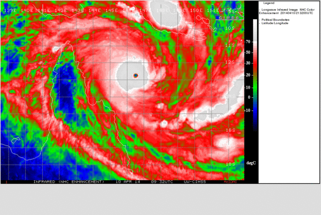
quote:De tropische storm Ita is uitgegroeid tot een cycloon en kan doorgroeien naar orkaancategorie 3. De storm raast boven de Coral Sea, een deel van de Grote Oceaan ten noordoosten van Australië, en koerst richting Queensland. Daar wordt Ita vrijdag aan land verwacht in het noorden van de Australische staat.
Eenmaal boven land neemt de cycloon naar verwachting in kracht af, maar kan wel voor hevige regenbuien zorgen. Het gebied waar Ita vermoedelijk overheen trekt, is dunbevolkt en staat bekend om haar mijnen en nationale parken.
http://wereldnieuws.blog.(...)-noordoost-australie
quote:A cyclone watch area has been expanded as tropical cyclone Ita – potentially the most powerful storm since Yasi – continues along its path towards the north Queensland coast.
Emergency services have asked residents between Cape Grenville and Cairns to finalise preparations as the category three storm, located south of Papua New Guinea, approaches Australia.
As at 4pm on Wednesday, cyclone Ita was 710 kilometres north-east of Cooktown, moving west at about 15 km/h and slowly intensifying. Wind gusts of 205km/h had already been recorded at the centre of the storm.
The Bureau of Meteorology expected cyclone Ita to make landfall between Lockhart River and Cape Flattery as a category four storm, with "very destructive winds" near the core and gales extending some distance from the landfall location.
Queensland Fire and Emergency Services northern regional director Wayne Coutts said residents had a limited timeframe to ensure their homes and families were ready.
Read more: http://www.brisbanetimes.(...)1.html#ixzz2yPUGJ665


Zie ook: WKN / Hurricane Season 2014: Orkanen & Cyclonen
[ Bericht 2% gewijzigd door Frutsel op 10-04-2014 13:43:33 ]

Queensland in Path of Cyclone Ita
Over the past few days, Tropical Cyclone Ita strengthened as it moved westward through the Coral Sea, reaching the equivalent of a hurricane.
Ita is expected to strengthen further in the coming days as it tracks westward then makes a turn toward the south later this week. Ita has the potential contain winds similar to that of a Category 3 hurricane as it approaches the coastline of northern Queensland on Friday.
The expected track will take the cyclone toward the Queensland coast line north of Cairns, an area with a lower population than areas farther south. This region is known for mining and national parks.
Peak winds at the time of landfall could reach as high as 200 kph (125 mph), leading to down trees and power lines with the potential for some minor structural damage.
As Ita approaches the coastline of Queensland a turn toward the south will occur taking the storm toward Cairns but also causing the storm to begin weakening due to interaction with land.
Although Ita will be weakening as it approaches Cairns, flooding rainfall and hurricane-force winds are expected. Conditions will begin to deteriorate around Cairns on Friday with the worst of the storm expected Friday night into Saturday.
Ita will then continue to the southeast near or just off the coast of Queensland over the weekend spreading heavy rainfall into Townsville and Mackay. Wind gusts over 50 mph will accompany the storm as it moves further southeast and away from Cairns.
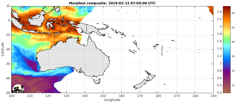
Rainfall will also be a concern as 75-150 mm (3-6 inches) will be common within 100 miles of the coastline from north of Cooktown southward to Mackay. Local amounts over 250 mm (10 inches) will be possible across the region with even higher amounts falling in the higher terrain to the south and west of Cairns.
http://www.accuweather.co(...)f-cyclone-1/25379809
[ Bericht 13% gewijzigd door #ANONIEM op 09-04-2014 19:29:42 ]

Over the past few days, Tropical Cyclone Ita strengthened as it moved westward through the Coral Sea, reaching the equivalent of a hurricane.
Ita is expected to strengthen further in the coming days as it tracks westward then makes a turn toward the south later this week. Ita has the potential contain winds similar to that of a Category 3 hurricane as it approaches the coastline of northern Queensland on Friday.
The expected track will take the cyclone toward the Queensland coast line north of Cairns, an area with a lower population than areas farther south. This region is known for mining and national parks.
Peak winds at the time of landfall could reach as high as 200 kph (125 mph), leading to down trees and power lines with the potential for some minor structural damage.
As Ita approaches the coastline of Queensland a turn toward the south will occur taking the storm toward Cairns but also causing the storm to begin weakening due to interaction with land.
Although Ita will be weakening as it approaches Cairns, flooding rainfall and hurricane-force winds are expected. Conditions will begin to deteriorate around Cairns on Friday with the worst of the storm expected Friday night into Saturday.
Ita will then continue to the southeast near or just off the coast of Queensland over the weekend spreading heavy rainfall into Townsville and Mackay. Wind gusts over 50 mph will accompany the storm as it moves further southeast and away from Cairns.
Rainfall will also be a concern as 75-150 mm (3-6 inches) will be common within 100 miles of the coastline from north of Cooktown southward to Mackay. Local amounts over 250 mm (10 inches) will be possible across the region with even higher amounts falling in the higher terrain to the south and west of Cairns.
http://www.accuweather.co(...)f-cyclone-1/25379809
[ Bericht 13% gewijzigd door #ANONIEM op 09-04-2014 19:29:42 ]
Uit nieuwsgierigheid: waarom verdient deze een eigen topic?
"For the man sound of body and serene of mind, there is no such thing as bad weather; Every day has its beauty. And storms which whip the blood, do make it pulse more vigorously."
Een cat.3 of 4 landfall verdient een eigen topic... de andere is meer centraal om te bespreken wat er broeit of algemene zaken over orkanen. Doen we soms ook met vulkanen of aardbevingen. Alles boven de 7.0 kan een eigen topic wat mij betreftquote:Op woensdag 9 april 2014 20:07 schreef Dven het volgende:
Uit nieuwsgierigheid: waarom verdient deze een eigen topic?
JTWC komt met een hoogste windsnelheid van 203 km/u (windstoten tot 250 km/u), waarmee het net geen cat 4 gaat worden.
Een aantal mensen wordt inmiddels geëvacueerd.
Een aantal mensen wordt inmiddels geëvacueerd.
quote:People are being evacuated between Cape Grenville and Cape Tribulation, just north of Cairns, as Cyclone Ita is upgraded to warning status.
http://www.theaustralian.(...)frg6nf-1226879686114

Cyclone Ita is expected to make landfall late on Friday.
STORM surges and flooding are expected to lash far north Queensland as cyclone Ita brings 280km/h winds, with 9000 people directly in its path.
Weather forecasters predict Ita will make landfall north of Cooktown on Friday night.
The category four system is expected to bring massive storm surges, predicted to be 1.5 metres bigger than usual high tides, in the coastal town of about 2300 people, 300 kilometres north of Cairns.
“The coastal storm surge - don’t underestimate it,” Premier Campbell Newman told reporters at Queensland’s emergency headquarters in Brisbane.
Cyclone Ita was about 470km northeast of Cooktown, travelling towards the coast about 14km/h, the Bureau of Meteorology said in a Thursday morning update.
The bureau’s regional director Robb Webb said Ita would move slower than Cyclone Yasi in 2011 and Cyclone Larry in 2006.
http://m.theaustralian.co(...)frg6nf-1226879686114
[ Bericht 5% gewijzigd door #ANONIEM op 10-04-2014 07:59:29 ]
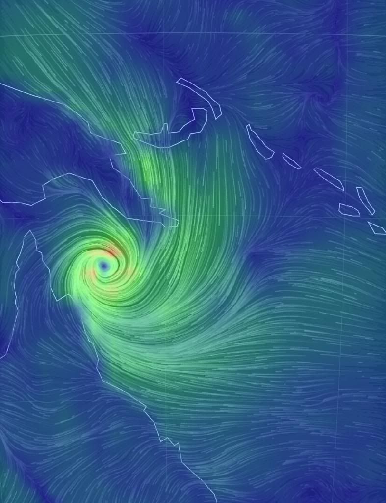
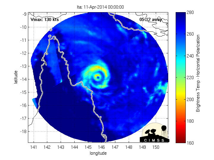
ITA kan een categorie 5 worden (volgens de Saffir en Simpson schaal). Omdat in Australië een andere schaal wordt gebruikt, wordt daar inmiddels al wel gesproken over een categorie 5.
JTWC laat een windveld van 250 km per uur zien met windstoten tot 305 km/u.
JTWC laat een windveld van 250 km per uur zien met windstoten tot 305 km/u.
De luchtdruk is gedaald naar 935 hpa met een windveld van 215 km/u (cat4 Saffir Simpson). De hoogte van de golven kan oplopen tot 9.5 meter.quote:24 HRS, VALID AT:
110600Z --- 14.6S 145.5E
MAX SUSTAINED WINDS - 135 KT, GUSTS 165 KT
WIND RADII VALID OVER OPEN WATER ONLY


quote:Ita upgraded to category 5
Cyclone Ita has been upgraded to a category five and is on its way to hit far north Queensland's coast.
Ita was upgraded late on Thursday afternoon. It is predicted to land north of Cooktown on Friday night, with a strong chance of coinciding with a 7pm high tide.
This would create dangerous storm surges, about 1.5 metres bigger than usual high tides, from Port Douglas to Cape Melville, Queensland's Bureau of Meteorology said.
The bureau's senior forecaster, Pradeep Singh, said heavy rain would also trigger flash floods.
He said while Ita was intense, it was a smaller system and would move slower than category five cyclone Yasi in 2011 and category four cyclone Larry in 2006.
It was expected to bring 280km/h winds when it hit the coast, with 9000 people directly in its path.
He said that although Ita was intense, it was a smaller system and would move slower than category five cyclone Yasi in 2011 and category four cyclone Larry in 2006.
Ita was about 420km north-east of Cooktown on Thursday afternoon. It was expected to bring 280km/h winds when it hit the coast, with 9000 people directly in its path.
Cooktown mayor Peter Scott said cyclone shelters were being put up Thursday night as winds of up to 100 km/h were forecast to hit the town on Friday morning.
"It's coming in faster and bigger than we first thought it was going to," he said while boarding up windows of his family home.
The Queensland premier, Campbell Newman, cut short an Asian trade trip and had arrived in Cooktown.
He pleaded for campers and residents in low-lying areas to seek safer shelter.
"There'll be lots of rain, 100mm of torrential rain. That means flooding of creeks and road crossings," he said. "If it's flooded, forget it. Please don't put your life at risk."
Staff and tourists have left Lizard Island, while 50 mine workers have abandoned the Cape Flattery silica mine township, north of Cooktown.
Some residents north of Port Douglas evacuated their homes on Thursday.
Local Dianne Fursdon said an eerie feeling had enveloped Cooktown.
"It's really strange, everything has gone quiet," she said. "There's no bird sounds, no geckos and the ants are all crawling onto higher ground."
Fursdon said she was confident her home would withstand the storm.
"Maybe the roof will come off, but what the hell," she said. "All I need is my plonk and I'll be fine."
Fourteen-year-old Kathleen Stevens, her aunt and great aunt were buying buckets and jerry cans to fill with water and fuel at the 11th hour.
They had been warned they might have to go without water and power for some time. The family was hopeful their home could withstand the force of potentially destructive winds.
"But if it gets really bad we're going to head to the cyclone shelter," Kathleen said.
Port Douglas boatie John Nagan, 70, said he planned a cyclone party.
“We'll get a couple of cartons of beer and a few bottles of white wine for the ladies,” he said from his yacht, which he plans to tether to mangroves in a river.
A cyclone watch has been declared for areas up to 300km inland, including Kalinga, Laura, Palmerville and Chillagoe.
Volgens mij ook. Cat 4 volgens Saffir Simpson.quote:
[ afbeelding ]
Cat.5 maar dat is volgens mij Australische schaal?

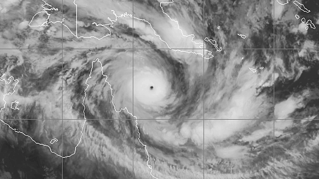
quote:CATEGORY-FIVE Cyclone Ita has been likened in sheer destructive force to Typhoon Haiyan that last year wiped out parts of South East Asia killing thousands in the strongest wind speed ever recorded.
Premier Campbell Newman has warned if the colossal tropical cyclone tracks south today it could impact tens of thousands of people in Port Douglas, Mossman and Cairns with the threat of tsunami-like storm surge.
Mr Newman toured Cooktown and Hope Vale as Cyclone Ita last night bore down on the far north Queensland frontier.
http://www.perthnow.com.a(...)ii5v6y-1226880411248

Category 4 Ita Nearing Australia
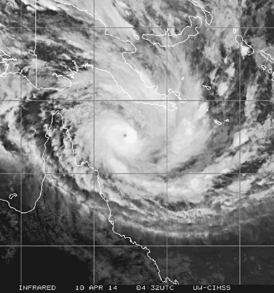
Dangerous Category 4 Tropical Cyclone Ita is nearing landfall in Australia’s Queensland state. Maximum sustained winds estimated by the Joint Typhoon Warning Center were 155 mph at 18 UTC on Thursday, just 1 mph below the threshold of Category 5 strength. The Australia’s Bureau of Meteorology estimated that Ita had a central pressure of 930 mb at 18 UTC. Satellite loops show a moderate-sized tropical cyclone surrounded by an intense eyewall with very cold cloud tops. Radar loops from Cairns, Australia show spiral bands from Ita are already bringing heavy rains to the coast. With moderate wind shear of 10 - 15 knots and ocean temperatures near 28°C, Ita should be able to maintain Category 4 strength until landfall occurs Friday evening local time in Australia. The center of Ita is likely to pass very close to Cooktown (population 2,400) as a major hurricane, and near Cairns (population 143,000) as a weakening Category 1 storm. Ita will likely be the strongest tropical cyclone to hit Queensland since Category 4 Tropical Cyclone Yasi hit on February 2, 2011. Yasi killed one person and did $3.6 billion in damage.
Ita passing close to location of world-record tropical cyclone high water mark
Storm surge is a huge concern from Ita, and the cyclone is passing just east of the location of the world record high water mark from a tropical cyclone: the 13 - 14.6 meters (43 - 48 feet) from Australia's March 5, 1899 Bathurst Bay Cyclone. That Category 5 storm was a monster, with sustained winds in excess of 175 mph, and a central pressure between 880 and 914 mb. Mahina killed at least 307 people, mostly on pearling ships, and was the deadliest cyclone in Australian history. The eyewitness account of Mahina's record storm surge was provided by Constable J. M. Kenny, who journeyed to Barrow Point on Bathurst Bay to investigate a crime on the day of the storm. While camped on a ridge 40 feet above sea level and 1/2 mile inland, Kenny's camp was inundated by a storm wave, reaching waist-deep. On nearby Flinders Island, fish and dolphins were found on top of 15 meter (49 foot) cliffs. However, an analysis by Nott and Hayne (2000) found no evidence of storm-deposited debris higher than 3 - 5 meters above mean sea level in the region. They also cited two computer storm surge simulations of the cyclone that were unable to generate a surge higher than three meters. Indeed, Bathurst Bay is not ideally situated to receive high storm surges. The Great Barrier Reef lies just 20 - 40 km offshore, and the ocean bottom near the bay is not shallow, but steeply sloped. Both of these factors should conspire to keep storm surges well below the record 13 - 14.6 meters reported. The authors concluded that the actual surge from the Bathurst Bay Cyclone may have been 3 - 5 meters. The observed inundation at 13 meters elevation, plus the observation of dolphins deposited at 15 meters above sea level could have been caused by high waves on top of the surge, they argue. Waves on top of the surge (called "wave run-up") can reach five times the wave height at the shore for steeply fronted coasts like at Bathurst Bay. Since waves in the Bathurst Bay Cyclone could easily have been 3 meters, 15 meters of wave run-up on top of the surge is quite feasible. Since wave run-up doesn't count as surge, the status of the 1899 Bathurst Bay Hurricane as the world record holder for storm surge is questionable. However, the event is certainly the world record holder for the high water mark set by a tropical cyclone's storm surge, an important category in its own right.
http://www.wunderground.c(...)t.html?entrynum=2661
quote:Details of Severe Tropical Cyclone Ita at 11:00 am EST:
.Centre located near...... 13.8 degrees South 145.7 degrees East
.Location accuracy........ within 15 kilometres
.Recent movement.......... towards the south southwest at 8 kilometres per hour
.Wind gusts near centre... 295 kilometres per hour
.Severity category........ 5
.Central pressure......... 931 hectoPascals
Orkaan Ita bereikt Australische kust
In het noordoosten van Australië is orkaan Ita aan land gekomen. Met windsnelheden van 230 kilometer per uur is het de krachtigste orkaan die het land treft in ruim drie jaar tijd.
Ita is een tropische storm in de categorie 4, wat betekent dat hij ernstige schade veroorzaakt. Naar verwachting waaien daken van huizen, vliegt er veel puin door de lucht en krijgen de Australiërs te maken met uitval van elektriciteit.
Evacuaties
Veel bewoners van de regio rond Cape Flattery, waar de storm aan land kwam, zijn geëvacueerd. Vooral huizen die voor 1985 gebouwd zijn, kunnen geen weerstand bieden aan de storm, denkt de Australische overheid.
Inwoners bereiden zich ook voor op overstromingen. Naar verwachting zorgt de orkaan voor flinke golven, waardoor lager gelegen gebieden onderlopen.
Naar verwachting trekt de orkaan richting het zuidwesten. Meteorologen denken dat de storm dan in kracht afneemt.
http://nos.nl/artikel/634(...)stralische-kust.html

Overstromingen na cycloon in Australië
In het noordoosten van Australië staan een paar dorpen onder water nadat cycloon Ita over het land trok, met heel wat hevige winden en regenval. Vooral het toeristische Cairns in Queensland kreeg het zwaar te verduren. Doden zijn er niet gevallen, maar er is heel wat schade. Het ergste lijkt nu wel achter de rug.
http://www.hln.be/hln/nl/(...)n-in-Australie.dhtml


Na Australië trekt ITA verder richting Nieuw Zeeland...
quote:An intense low of tropical origin should be approaching the North Island on Thursday and move slowly southwards on Friday to lie west of central New Zealand. This is likely to bring strong to gale east to northeast winds and moderate to heavy rain to many North Island areas. There is some uncertainty in the predicted position of the low which will determine which areas get the most wind and rain. There is moderate confidence that a rainfall and wind warning will be needed on Thursday in the north of the North Island from Northland down to Taranaki, Taihape and the ranges of Gisborne and Hawkes Bay. For Friday, there is moderate confidence that a rainfall warning will continue in Coromandel Peninsula, Bay of Plenty and northern Gisborne. There is also moderate confidence that a rainfall warning will be needed in Nelson and northwest Marlborough (including the Marlborough Sounds) on Thursday and Friday.
Steady rain is likely in the east of the South Island during Thursday and Friday and there is low confidence that amounts will require a rainfall warning along the Kaikoura Coast, Canterbury Plains and North Otago on Thursday or Friday.


More than 6000 homes and businesses remain without power in the far north as Cyclone Ita begins to move away from the Queensland coast.
Ergon Energy has restored power to about 20,000 properties since noon on Sunday, although Premier Campbell Newman said the worst-hit areas could go weeks without electricity.
On Monday morning, Energy Minister Mark McArdle said vegetation damage and issues with access had made it difficult to restore power to parts of Kuranda and the Cairns northern beaches.

http://www.brisbanetimes.(...)-20140414-36m7d.html
|
|