WKN Weer, Klimaat en Natuurrampen
Lees alles over het onstuimige weer op onze planeet, volg orkanen en tornado's, zie hoe vulkanen uitbarsten en hoe Moeder Aarde beeft bij een aardbeving. Alles over de verwoestende kracht van onze planeet en tal van andere natuurverschijnselen.


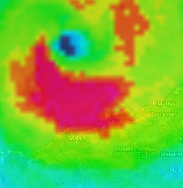
Tropical Cyclone Hellen
Momenteel een windveld van 241 km/u, met windstoten tot 300 km/u. Wind gaat verder toenemen tot bijna 260 km/u met windstoten tot 314 km/u. Hiermee wordt het een categorie 5.
De provincie Mahajanga lijkt het zwaarst te worden getroffen door deze extreme cycloon en dan vooral het district Soalala.Hellen zal voor overstromingen, landverschuivingen en zware schade zorgen.


Cat5 is dat niet uitzonderlijk voor die regio? Ik zag je vandaag of gister nog cat.2 typen. Gaat hard dan zeg 
The penguins, the penguins 
"We meet every day at the same cafe, six-thirty and no one knows she'll be there."
Ik heb hier (vooral aan deze kant van Madagascar) nog niet eerder cat 5 gezien idd.quote:Op zondag 30 maart 2014 20:41 schreef Frutsel het volgende:
Cat5 is dat niet uitzonderlijk voor die regio? Ik zag je vandaag of gister nog cat.2 typen. Gaat hard dan zeg
Maar orkanen komen hier veel voor...kans is dan aanwezig dat het dan een keer een cat5 is.

Extremely dangerous Category 4 Tropical Cyclone Hellen is bearing down on Madagascar after an extraordinary burst of rapid intensification brought the cyclone from a 60 mph tropical storm to a high-end Category 4 storm with 150 mph winds in just 24 hours. That 90 mph increase in winds in 24 hours is not far below the record intensification rate of Hurricane Wilma in 2005, which was 110 mph in 24 hours. Official bulletins from La Réunion indicate the central pressure dropped 61 mb in 24 hrs, from 986mb at 1800 UTC Saturday to 925mb at 1800 UTC Sunday. They warn in their 18 UTC Sunday advisory:
HELLEN IS LIKELY TO BE ONE OF THE MOST POWERFUL TROPICAL CYCLONE EVER SEEN OVER THE NORTHERN CHANNEL SINCE THE SATELLITE ERA (1967). THE LIKELIHOOD IS INCREASING FOR AN EXTREMELY DANGEROUS TROPICAL CYCLONE LANDFALL OVER THE NORTHWESTERN COASTLINE OF MADAGASCAR BETWEEN CAPE SAINT-ANDRE AND MAHAJONGA. THE RSMC TROPICAL CYCLONE STORM SURGE NWP HAS BEEN RUN AND SHOWS PHENOMENAL SEA ELEVATIONS IN THE AREA EXPOSED TO THE NORTHERLY WINDS (EAST OF THE FORECAST TRACK). THE STORM SURGE COULD REACH 2 - 4 METERS (7 - 13 FEET) IN THE ESTUARY OF THE BETSIBOKA RIVER (MAHAJONGA), AND MORE THAN 7 METERS (23 FEET) IN THE BAY OF BALY (SOALALA), AND 1 - 4 METERS ON THE COASTLINE EAST OF CAPE SAINT-ANDRE. ALL PREPARATIONS FOR A "WORST CASE" SCENARIO SHOULD BE UNDERWAY.
bron: Jeff Masters
HELLEN IS LIKELY TO BE ONE OF THE MOST POWERFUL TROPICAL CYCLONE EVER SEEN OVER THE NORTHERN CHANNEL SINCE THE SATELLITE ERA (1967). THE LIKELIHOOD IS INCREASING FOR AN EXTREMELY DANGEROUS TROPICAL CYCLONE LANDFALL OVER THE NORTHWESTERN COASTLINE OF MADAGASCAR BETWEEN CAPE SAINT-ANDRE AND MAHAJONGA. THE RSMC TROPICAL CYCLONE STORM SURGE NWP HAS BEEN RUN AND SHOWS PHENOMENAL SEA ELEVATIONS IN THE AREA EXPOSED TO THE NORTHERLY WINDS (EAST OF THE FORECAST TRACK). THE STORM SURGE COULD REACH 2 - 4 METERS (7 - 13 FEET) IN THE ESTUARY OF THE BETSIBOKA RIVER (MAHAJONGA), AND MORE THAN 7 METERS (23 FEET) IN THE BAY OF BALY (SOALALA), AND 1 - 4 METERS ON THE COASTLINE EAST OF CAPE SAINT-ANDRE. ALL PREPARATIONS FOR A "WORST CASE" SCENARIO SHOULD BE UNDERWAY.

bron: Jeff Masters
Tropical Cyclone Hellen: Massive Storm Surge Threatens Madagascar Coast
A powerful tropical cyclone over the southwest Indian Ocean is threatening Madagascar with potentially life-threatening storm surge after undergoing a period of very rapid intensification over the weekend.
According to a bulletin issued by the Regional Specialized Meteorological Centre (RSMC) at La Reunion at 1845 GMT (2:45 p.m. EDT in the U.S.) Sunday, Tropical Cyclone Hellen was packing 10-minute average winds as high as 145 miles per hour – the equivalent of about 150 miles per hour, or a Category 4 hurricane, using the U.S. standard 1-minute average wind.
The centre's bulletin six hours later indicated slight weakening, with 10-minute average winds of about 125 miles per hour as of 0000 UTC Monday (8 p.m. EDT Sunday), the equivalent of a borderline Category 3/4 hurricane using U.S. wind measurement standards.
Hellen was lurking just off the northwest coast of Madagascar and moving slowly to the south-southeast at about 3 mph late Sunday, the agency said.
RSMC La Reunion estimated the cyclone's central pressure at 925 millibars as of 1800 GMT (2 p.m. US EDT) Sunday, a dizzying drop of 61 millibars from 24 hours earlier. The pressure drop coincided with an increase in Hellen's maximum winds from about 65 mph (10-minute average) to 145 miles per hour within that same 24-hour period. The agency estimated a central pressure of 940 millibars later Sunday as the storm weakened slightly.
Generally, stronger central pressures correspond to stronger winds in tropical cyclones (including hurricanes and typhoons). The National Hurricane Center defines "rapid intensification" as occurring when the maximum sustained winds in a tropical cyclone increase by at least 30 knots, or about 35 miles per hour, in a 24-hour period.
Storm Surge: "Worst Case Scenario" Possible
Tropical Cyclone Hellen Forecast
Forecast track for Tropical Cyclone Hellen. Yellow circles indicate possible positions of the cyclone's center at the indicated times. Image courtesy Weather Underground.
Tropical Cyclone Hellen page at Wunderground.com
Hellen is forecast to sideswipe the northwestern coast of Madagascar Monday (U.S. time), affecting the administrative regions of Boeny and Melaky. The two regions had a combined population of just over 700,000 in 2004. Melaky is the least densely populated region in all of Madagascar.
Unfortunately, because winds blow clockwise around Southern Hemisphere tropical cyclones, populated areas east of the cyclone's track will be in an area of strong northerly onshore winds, putting them at risk for dangerous storm surge.
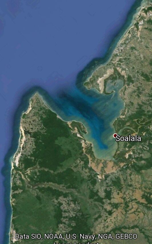
In its Sunday afternoon (U.S. time) bulletin, RSMC La Reunion said its storm-surge model "shows phenomenal sea elevations in the area exposed to the northerly winds (east of the forecast track)." The agency said the storm surge could exceed 7 meters (23 feet) in the Bay of Baly, affecting the town of Soalala (population 15,000). Farther east, the regional capital of Mahajanga (population at least 130,000) could see a storm surge of 2 to 4 meters (6 to 13 feet).
"All preparations for a 'worst case' scenario should be underway," the bulletin warned.
After clipping Madagascar, Hellen is forecast to make a sharp right turn, taking it westward across the Mozambique Channel toward the mainland African nation of Mozambique as a much weaker storm.
However, the Sunday evening (U.S. time) bulletin from La Reunion indicated that the turn to the west had not yet materialized. According to the update, "Hellen remains an extremely dangerous tropical cyclone and the landfall area would probably be more eastern than previously expended and therefore more close to the densely populated area of Mahajanga."
The forecasters said that if the landfall point stays to the west, the Soalala area could still see life-threatening storm surge, somewhere between 5 and 7 meters (16 to 23 feet). The surge forecast remained unchanged for Mahajanga, the larger city. The agency reiterated its worst-case scenario clause from the prior bulletin.
Tropical Cyclones in the Southwest Indian Ocean
The primary season for tropical cyclones in the Southwest Indian Ocean basin runs from November through April.
Madagascar's deadliest and most destructive tropical cyclone in modern times, Gafilo, made landfall on March 7, 2004, in northeast Madagascar with maximum sustained winds near 160 mph. It tore a path westward across northern Madagascar, then recurved over the Mozambique Channel and meandered east across southern Madagascar March 9-12. At least 237 people died in Madagascar.
Gafilo was also the strongest tropical cyclone on record in the Southwest Indian Ocean basin, bottoming out at a minimum central pressure of 895 millibars.
Stay with The Weather Channel and weather.com for updates on Tropical Cyclone Hellen and its potentially devastating impact on Madagascar.
http://www.weather.com/ne(...)-madagascar-20140330
A powerful tropical cyclone over the southwest Indian Ocean is threatening Madagascar with potentially life-threatening storm surge after undergoing a period of very rapid intensification over the weekend.
According to a bulletin issued by the Regional Specialized Meteorological Centre (RSMC) at La Reunion at 1845 GMT (2:45 p.m. EDT in the U.S.) Sunday, Tropical Cyclone Hellen was packing 10-minute average winds as high as 145 miles per hour – the equivalent of about 150 miles per hour, or a Category 4 hurricane, using the U.S. standard 1-minute average wind.
The centre's bulletin six hours later indicated slight weakening, with 10-minute average winds of about 125 miles per hour as of 0000 UTC Monday (8 p.m. EDT Sunday), the equivalent of a borderline Category 3/4 hurricane using U.S. wind measurement standards.
Hellen was lurking just off the northwest coast of Madagascar and moving slowly to the south-southeast at about 3 mph late Sunday, the agency said.
RSMC La Reunion estimated the cyclone's central pressure at 925 millibars as of 1800 GMT (2 p.m. US EDT) Sunday, a dizzying drop of 61 millibars from 24 hours earlier. The pressure drop coincided with an increase in Hellen's maximum winds from about 65 mph (10-minute average) to 145 miles per hour within that same 24-hour period. The agency estimated a central pressure of 940 millibars later Sunday as the storm weakened slightly.
Generally, stronger central pressures correspond to stronger winds in tropical cyclones (including hurricanes and typhoons). The National Hurricane Center defines "rapid intensification" as occurring when the maximum sustained winds in a tropical cyclone increase by at least 30 knots, or about 35 miles per hour, in a 24-hour period.
Storm Surge: "Worst Case Scenario" Possible
Tropical Cyclone Hellen Forecast
Forecast track for Tropical Cyclone Hellen. Yellow circles indicate possible positions of the cyclone's center at the indicated times. Image courtesy Weather Underground.
Tropical Cyclone Hellen page at Wunderground.com
Hellen is forecast to sideswipe the northwestern coast of Madagascar Monday (U.S. time), affecting the administrative regions of Boeny and Melaky. The two regions had a combined population of just over 700,000 in 2004. Melaky is the least densely populated region in all of Madagascar.
Unfortunately, because winds blow clockwise around Southern Hemisphere tropical cyclones, populated areas east of the cyclone's track will be in an area of strong northerly onshore winds, putting them at risk for dangerous storm surge.
In its Sunday afternoon (U.S. time) bulletin, RSMC La Reunion said its storm-surge model "shows phenomenal sea elevations in the area exposed to the northerly winds (east of the forecast track)." The agency said the storm surge could exceed 7 meters (23 feet) in the Bay of Baly, affecting the town of Soalala (population 15,000). Farther east, the regional capital of Mahajanga (population at least 130,000) could see a storm surge of 2 to 4 meters (6 to 13 feet).
"All preparations for a 'worst case' scenario should be underway," the bulletin warned.
After clipping Madagascar, Hellen is forecast to make a sharp right turn, taking it westward across the Mozambique Channel toward the mainland African nation of Mozambique as a much weaker storm.
However, the Sunday evening (U.S. time) bulletin from La Reunion indicated that the turn to the west had not yet materialized. According to the update, "Hellen remains an extremely dangerous tropical cyclone and the landfall area would probably be more eastern than previously expended and therefore more close to the densely populated area of Mahajanga."
The forecasters said that if the landfall point stays to the west, the Soalala area could still see life-threatening storm surge, somewhere between 5 and 7 meters (16 to 23 feet). The surge forecast remained unchanged for Mahajanga, the larger city. The agency reiterated its worst-case scenario clause from the prior bulletin.
Tropical Cyclones in the Southwest Indian Ocean
The primary season for tropical cyclones in the Southwest Indian Ocean basin runs from November through April.
Madagascar's deadliest and most destructive tropical cyclone in modern times, Gafilo, made landfall on March 7, 2004, in northeast Madagascar with maximum sustained winds near 160 mph. It tore a path westward across northern Madagascar, then recurved over the Mozambique Channel and meandered east across southern Madagascar March 9-12. At least 237 people died in Madagascar.
Gafilo was also the strongest tropical cyclone on record in the Southwest Indian Ocean basin, bottoming out at a minimum central pressure of 895 millibars.
Stay with The Weather Channel and weather.com for updates on Tropical Cyclone Hellen and its potentially devastating impact on Madagascar.
http://www.weather.com/ne(...)-madagascar-20140330

The extreme intensification, combined with the path of the storm and the fact that winds blow clockwise around Southern Hemisphere tropical cyclones, raised fears of a deadly storm surge for coastal towns along the country's northwestern coastline.
Bulletins from RSMC La Reunion Sunday afternoon and evening warned that the town of Soalala (population 15,000), on the Bay of Baly, was at risk of a storm surge as high as 7 meters (23 feet). Farther east, the city and regional capital of Mahajanga (population 130,000) was warned of a 2- to 4-meter (6- to 13-foot) storm surge.
"All preparations for a 'worst case' scenario should be underway," the agency's bulletins warned late Sunday.
Sudden Weakening
Fortunately for coastal residents, Hellen weakened as quickly as it strengthened.
By 0600 GMT (2 a.m. EDT) Monday, Hellen's pressure had risen back to 975 millibars and its 10-minute average winds had fallen to 80 mph, according to the centre's bulletin. The cyclone's forward movement had come to a virtual halt, the agency said, as its rainbands and strong winds pushed into northwest Madagascar.
In just 12 hours, the cyclone's estimated central pressure had risen a staggering 50 millibars, in essence, reversing most of the rapid intensification occurring earlier Sunday.
The reasons for this rapid weakening were not clear, according to the RSMC, except for a strengthening north to northeast winds aloft which may have provided increased wind shear to rip apart the circulation.
By 1200 GMT (8 a.m. EDT) Monday, Hellen had moved inland and weakened further with maximum winds of 50 mph and a central pressure of 990 millibars.
Impact
Hellen's landfall brought blustery conditions and heavy rain to northwest Madagascar, primarily in the administrative regions of Boeny and Melaky. The two regions had a combined population of just over 700,000 in 2004. Melaky is the least densely populated region in all of Madagascar.
In Mahajanga, the capital of Boeny and Madagascar's second-busiest seaport, observations indicated 156 mm (6.14 inches) of rain in the 42-hour period ending 1200 GMT (8 a.m. EDT) Monday. Wind gusts at the city's Amborovy Airport peaked at 46 mph at 0500 GMT (1 a.m. EDT) Monday.
While there are no readily available measurements of storm surge in the region, photos from the scene indicated that even the much-weakened storm had caused some damage to vulnerable structures on the immediate coastline in Mahajanga.
Forecasters at La Reunion said Hellen is forecast to continue a right turn, taking it westward across the Mozambique Channel toward the mainland African nation of Mozambique without much restrengthening. The agency's Monday morning bulletin suggested Hellen could even dissipate over Madagascar without making it back over water.
Tropical Cyclones in the Southwest Indian Ocean
The primary season for tropical cyclones in the Southwest Indian Ocean basin runs from November through April.
Madagascar's deadliest and most destructive tropical cyclone in modern times, Gafilo, made landfall on March 7, 2004, in northeast Madagascar with maximum sustained winds near 160 mph. It tore a path westward across northern Madagascar, then recurved over the Mozambique Channel and meandered east across southern Madagascar March 9-12. At least 237 people died in Madagascar.
Gafilo was also the strongest tropical cyclone on record in the Southwest Indian Ocean basin, bottoming out at a minimum central pressure of 895 millibar.
|
|