WKN Weer, Klimaat en Natuurrampen
Lees alles over het onstuimige weer op onze planeet, volg orkanen en tornado's, zie hoe vulkanen uitbarsten en hoe Moeder Aarde beeft bij een aardbeving. Alles over de verwoestende kracht van onze planeet en tal van andere natuurverschijnselen.


Super Tyfoon USAGI
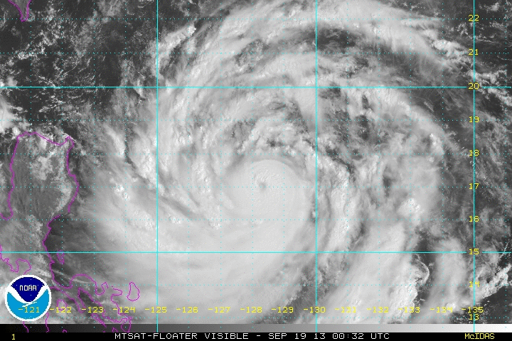
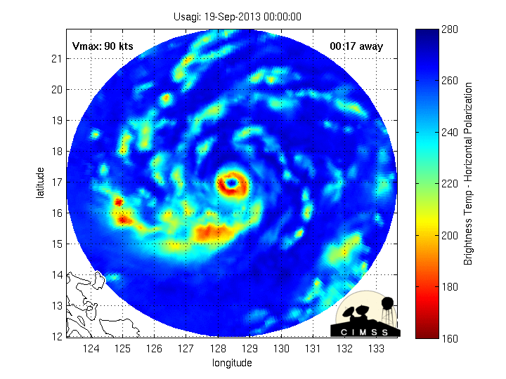
Boven de west pacific is een indrukwekkende tyfoon ontstaan. Usagi is momenteel een categorie 4 op de schaal van Saffir-Simpson en zal nog in kracht toenemen tot een categorie 5. De windsnelheid loopt op tot 220 km/u, waarbij windstoten voorkomen tot 265 km/u. De kerndruk is gedaald naar 935 mb.
De verwachting is dat de tyfoon net onder het zuiden van Taiwan zal trekken en ten noorden van de Filipijnen. Wat er daarna zal gebeuren is nog niet geheel zeker, maar TSR laat een landfall zien recht op Hong Kong.
Zoals te zien op de animatie hebben de eerste neerslagbanden de Filipijnen al bereikt en ook op de radar van Taiwan zijn de eerste tekenen van Usagi al zichtbaar.
Het is nog even afwachten wat er gaat gebeuren. GFS laat het systeem vrij snel doortrekken richting China, andere modellen laten het juist wat afremmen in de buurt van Taiwan.
Zie ook: WKN / [ACTUEEL] Hurricane Season 2013 #2 Orkanen en Cyclonen (hier is b.v. ook te zien hoe hoog de storm surge is die bij een cat 5 hoort).
http://www.tropicalstormrisk.com/
http://www.tropicalstormrisk.com/
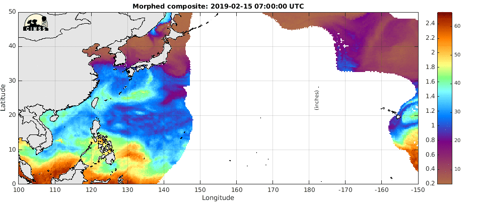
Hieronder; de hoeveelheid vocht. De draai is hier goed te zien. Ten oosten van Usagi is nog een systeem aan het ontstaan.
Boven de west pacific is een indrukwekkende tyfoon ontstaan. Usagi is momenteel een categorie 4 op de schaal van Saffir-Simpson en zal nog in kracht toenemen tot een categorie 5. De windsnelheid loopt op tot 220 km/u, waarbij windstoten voorkomen tot 265 km/u. De kerndruk is gedaald naar 935 mb.
De verwachting is dat de tyfoon net onder het zuiden van Taiwan zal trekken en ten noorden van de Filipijnen. Wat er daarna zal gebeuren is nog niet geheel zeker, maar TSR laat een landfall zien recht op Hong Kong.


Zoals te zien op de animatie hebben de eerste neerslagbanden de Filipijnen al bereikt en ook op de radar van Taiwan zijn de eerste tekenen van Usagi al zichtbaar.
Het is nog even afwachten wat er gaat gebeuren. GFS laat het systeem vrij snel doortrekken richting China, andere modellen laten het juist wat afremmen in de buurt van Taiwan.
Zie ook: WKN / [ACTUEEL] Hurricane Season 2013 #2 Orkanen en Cyclonen (hier is b.v. ook te zien hoe hoog de storm surge is die bij een cat 5 hoort).
http://www.tropicalstormrisk.com/
http://www.tropicalstormrisk.com/
Hieronder; de hoeveelheid vocht. De draai is hier goed te zien. Ten oosten van Usagi is nog een systeem aan het ontstaan.

Zondag in Hongkong, Zaterdag zal Taiwan de meeste ellende krijgenquote:Op donderdag 19 september 2013 12:26 schreef Dawnbreaker het volgende:
en wanneer is die landfall ongeveer?

Ongeveer 7 miljoen inwoners...en dan nog een groot gebied eromheen met miljoenen mensen.quote:
Recht op Hong Kong
En zuidelijk Taiwan zal ook een flinke lading krijgen

Dangerous Typhoon Usagi headed for Taiwan and Hong Kong
JeffMastersquote:In the Western Pacific, powerful and dangerous Typhoon Usagi has intensified to a Category 4 storm with 140 mph winds. Further intensification is likely over the next day, as Usagi is over very warm waters of 29 - 30°C with high heat content, and is under light wind shear of 5 - 10 knots. The official JTWC forecast brings Usagi to a Category 5 super typhoon by Friday, which would make Usagi Earth's first Category 5 storm of 2013. Usagi will pass very close to the southern tip of Taiwan at 06 UTC Saturday (2 am EDT), and interaction with land could potentially weaken the storm. However, Usagi is still expected to be a major Category 3 typhoon when it makes landfall near Hong Kong at approximately 00 UTC Sunday (8 pm EDT Saturday.) Satellite images show that Usagi is a large and very impressive typhoon with a prominent eye surrounded by a thick eyewall with intense thunderstorms that reach high into the atmosphere.
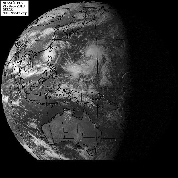
De Filipijnen krijgen nu de meeste neerslag, maar ook in Taiwan zal het geweld straks losbarsten.
De druk is gedaald naar 920 mb. Het is nu een categorie 5.
De druk is gedaald naar 920 mb. Het is nu een categorie 5.

Achter USAGI lijkt ook nog een enorm complex te volgen?
Heeft dat ook potentie of trekt USAGI alle energie weg?
Heeft dat ook potentie of trekt USAGI alle energie weg?
Lijkt ook een zware te worden, maar trekt meer noordwaarts volgens mij.quote:
Achter USAGI lijkt ook nog een enorm complex te volgen?
Heeft dat ook potentie of trekt USAGI alle energie weg?
Het is toch vooral de Filipijnen wat zeer veel neerslag krijgt van supertyfoon Usagi. Taiwan gaat ook nog wat krijgen. Zwaarste windveld is voor Taiwan. Luchtdruk is verder gedaald naar 910mb.

USAGI is nog steeds een categorie 5 met een windsnelheid die oploopt tot 260 km/u (windstoten rond de 310 km). De kerndruk ligt nog steeds rond de 910mb. De verwachting is dat het systeem landfall maakt bij Hong Kong.


Slecht scenario voor Hong Kong. De tyfoon passeert aan de zuidkant, wat betekent dat de stad het zwaarste windveld gaat krijgen. (dat zit n.l. aan de rechterkant van het systeem).
Windsnelheid bij de kern loopt nog op tot 240 km/u met windstoten tot bijna 300 km. De luchtdruk is iets opgelopen en zit nu rond de 915mb.
De hoeveelheid neerslag komt op Taiwan op sommige plekken al boven de 200 mm uit.
[ Bericht 16% gewijzigd door #ANONIEM op 21-09-2013 03:10:05 ]
Windsnelheid bij de kern loopt nog op tot 240 km/u met windstoten tot bijna 300 km. De luchtdruk is iets opgelopen en zit nu rond de 915mb.
De hoeveelheid neerslag komt op Taiwan op sommige plekken al boven de 200 mm uit.

[ Bericht 16% gewijzigd door #ANONIEM op 21-09-2013 03:10:05 ]
Ze mogen de noodtoestand wel uitroepen voor Hong Kong. Usagi nadert als cat4...ben benieuwd of deze stad beter beschermd is dan New York was tegen Sandy.
Dat is nog een understatement zelfs. Direct tegen Hong Kong aan ligt (over de grens in China) Shenzhen met 10+ miljoen inwoners.quote:Op donderdag 19 september 2013 12:31 schreef aloa het volgende:
[..]
Ongeveer 7 miljoen inwoners...en dan nog een groot gebied eromheen met miljoenen mensen.
Boh, wat zullen die windsnelheden zijn in al die enorm smalle straatjes tussen de gigantische wolkenkrabbers in Hong Kong? Dat worden ware windtunnels.
Opgeblazen gevoel of winderigheid? Zo opgelost met Rennie!
Dat ook nog idd. De mensen kunnen beter binnen blijven.quote:
[..]
Dat is nog een understatement zelfs. Direct tegen Hong Kong aan ligt (over de grens in China) Shenzhen met 10+ miljoen inwoners.
Boh, wat zullen die windsnelheden zijn in al die enorm smalle straatjes tussen de gigantische wolkenkrabbers in Hong Kong? Dat worden ware windtunnels.


JeffMastersquote:Dangerous Category 3 Typhoon Usagi is charging through the Luzon Strait between Taiwan and the Philippines on its way towards China, where landfall is expected early Monday morning local time (near 2 pm EDT on Sunday) near Hong Hong. The typhoon battered the northern Philippine Batanes Islands overnight with wind gusts of up to 155 mph (250 kph), ripping down power lines and damaging crops, according to the South China Morning Post. Torrential rains of over a foot (305 mm) have fallen in 24 hours over eastern Taiwan, where Usagi's counterclockwise flow of moist air rode up over the high mountains of the island. Usagi reached its peak strength on Thursday, taking advantage of low wind shear and very warm waters 30°C with high heat content, to intensify to a Category 5 super typhoon with 160 mph winds. On Friday, Usagi began an eyewall replacement cycle that the typhoon is still attempting to complete. This process, where the inner eyewall collapses and a new, larger-diameter eyewall forms from an outer spiral band, typically causes a reduction in intensity by one Saffir-Simpson category, but spreads out the storm's hurricane-force winds over a larger area. Satellite images show that Usagi has lost its symmetry and the cloudtops have warmed, indicating weakening; this weakening is likely due to disruption of the low-level inflow by the high mountains of Taiwan. Wind shear is low, near 10 knots, but ocean temperatures have cooled to about 29°C, and the heat content of the waters is much lower than on Friday.
Forecast for Usagi
Continued slow weakening of Usagi is likely as the storm tries to complete its eyewall replacement cycle as ocean temperatures cool to 28°C and the heat content of the water diminishes. By the time Usagi reaches the coast near Hong Hong in the early morning hours on Monday (local time), the storm should be at Category 2 strength. This is still strong enough to pose a formidable storm surge, wind, and heavy rain threat to China, and Usagi is likely to be one of the five strongest typhoons to affect Hong Hong in the past 50 years. If the eye of the storm hits just west of Hong Kong, a large storm surge capable of causing over a billion dollars in damage will inundate portions of the coast along the bay that Hong Kong, Macau, and Shenzhen share. Wunderground's weather historian, Christopher C. Burt, will be posting a summary of Hong Hong's typhoon history on Saturday afternoon around 4 pm EDT. The most notable typhoon to hit Hong Kong in the past 50 years was Typhoon Rose of 1971, which sank over 300 boats and killed 110 people.
|
|