WKN Weer, Klimaat en Natuurrampen
Lees alles over het onstuimige weer op onze planeet, volg orkanen en tornado's, zie hoe vulkanen uitbarsten en hoe Moeder Aarde beeft bij een aardbeving. Alles over de verwoestende kracht van onze planeet en tal van andere natuurverschijnselen.


Deze week weer kansen op tornado's. Vooral dinsdag en woensdag is de kans groot (plaatselijke tijd).
2 reports. Lichte schade door waterhozen die het land optrokken.
[ Bericht 71% gewijzigd door #ANONIEM op 15-04-2013 07:17:17 ]
quote:1930 1 W EASTPOINT FRANKLIN FL 2975 8489 ROOF DAMAGE TO TWO MOBILE HOMES IN EASTPOINT FROM LANDFALLING WATERSPOUT. (TAE)
1933 EASTPOINT FRANKLIN FL 2975 8487 WATERSPOUT MOVED ONSHORE CAUSING MINOR DAMAGE IN EASTPOINT.
[ Bericht 71% gewijzigd door #ANONIEM op 15-04-2013 07:17:17 ]

Kan woensdagavond/donderdagnacht wel heftig worden. Staat nog steeds een moderate risk voor woensdag. Groot gebied rond Oklahoma.

Waaronder Norman (is dat niet de thuisbasis van Reed Timmer?) en Joplinquote:Op dinsdag 16 april 2013 10:19 schreef aloa het volgende:
Kan woensdagavond/donderdagnacht wel heftig worden. Staat nog steeds een moderate risk voor woensdag. Groot gebied rond Oklahoma.
quote:Op dinsdag 16 april 2013 10:20 schreef Frutsel het volgende:
[..]
Waaronder Norman (is dat niet de thuisbasis van Reed Timmer?) en Joplin
<a href="http://www.vwkweb.nl/" rel="nofollow" target="_blank">Vereniging voor weerkunde en klimatologie</a>
<a href="http://www.estofex.org/" rel="nofollow" target="_blank">ESTOFEX</a>
<a href="http://www.estofex.org/" rel="nofollow" target="_blank">ESTOFEX</a>
Kan hij het mooi vastleggenquote:
[..]
Waaronder Norman (is dat niet de thuisbasis van Reed Timmer?) en Joplin

quote:Major Tornado outbreak on the way
A major outbreak of severe thunderstorms is possible beginning Wednesday across the central and southern Plains. This could be one of the worst outbreaks of the year.
Cities with the greatest potential for severe weather into Wednesday night include Dallas, Wichita Falls, and Abilene, Texas, Oklahoma City and Tulsa, Okla., Chanute, Kan., and Joplin, and Springfield, Mo., to name a few.
Dangerous severe thunderstorms are expected to develop during the early to mid-afternoon hours and continue well into the evening Wednesday.
Tornadoes will be the biggest danger with these storms. While not every storm will produce a tornado, those that do have the possibility to be rather strong and could be on the ground for an extended period.
According to Expert Senior Meteorologist Alex Sosnowski, "Unlike the setup last week where cold air undercut the prime area for thunderstorms, this time the air is not quite as cold and seems to be holding farther north and west."
"The setup last week yielded elevated thunderstorms (storms with the base of the clouds high off the ground) that were mostly hail producers," Sosnowski said, "Storms during the middle of this week over the Plains are likely to have a lower base and a greater risk of damaging wind and tornadoes along with an ongoing large hail threat."
A southerly flow of moist air at the surface will back to the west and become colder and drier higher above the ground. This shifting of wind with height, referred to by the weather community as wind shear will contribute to the severity of the storms and may allow some of them to rotate. Rotating thunderstorms have a greater likelihood of producing a tornado.
quote:
[..]
Waaronder Norman (is dat niet de thuisbasis van Reed Timmer?) en Joplin
You better lose yourself in the music
The moment, you own it, you better never let it go
The moment, you own it, you better never let it go
Mousequote:
[..], ik ben er weer hoor, en zit er klaar voor. Hoop dat steden als Joplin dit jaar bespaard blijven.
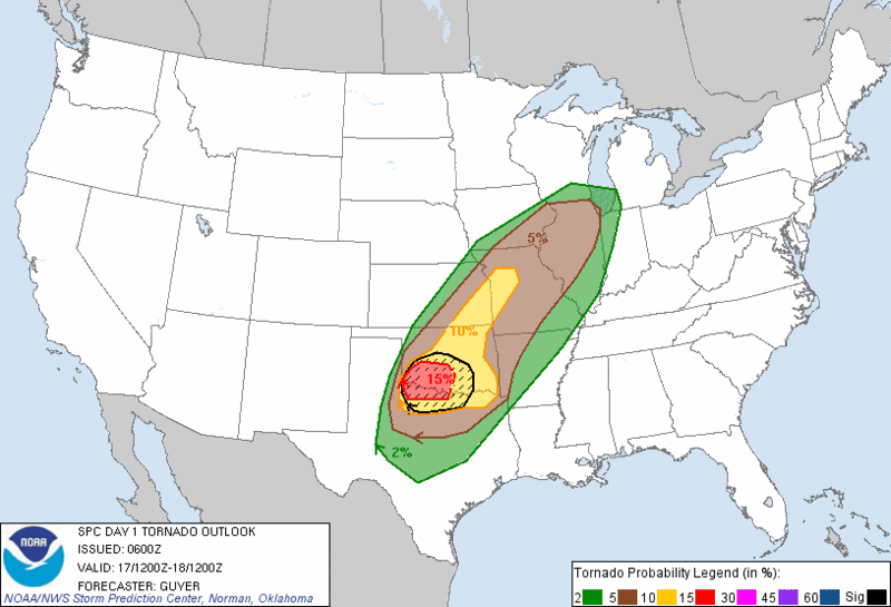
Wichita Falls, Lawton vallen in dat 15% gebied... Joplin, Norman, Oklahoma City net in het 10% denk ik.
Maar ook Dallas en Forth Worth zijn allerminst veilig
edit: vanaf hoelaat (NL-tijd) kunnen we daar de 'rotzooi' verwachten?
Maar ook Dallas en Forth Worth zijn allerminst veilig
edit: vanaf hoelaat (NL-tijd) kunnen we daar de 'rotzooi' verwachten?
Ik gok op een uur of 8/9 (hier) dat de eerste buien komen. later vanavond en vannacht ontstaan dan de zwaardere cellen. Zal hier in Nederland nachtwerk worden en morgenochtend nog...

Hagel met een doorsnee van 5 cm in de buien in het noorden van de VS.
Kleine kans op een tornado.
Severe Thunderstorm Watch 113
[ Bericht 0% gewijzigd door #ANONIEM op 17-04-2013 16:46:17 ]
Kleine kans op een tornado.
Severe Thunderstorm Watch 113

quote:URGENT - IMMEDIATE BROADCAST REQUESTED
SEVERE THUNDERSTORM WATCH NUMBER 113
NWS STORM PREDICTION CENTER NORMAN OK
915 AM CDT WED APR 17 2013
THE NWS STORM PREDICTION CENTER HAS ISSUED A
* SEVERE THUNDERSTORM WATCH FOR PORTIONS OF
SOUTHERN IOWA
NORTHERN ILLINOIS
NORTHERN MISSOURI
LAKE MICHIGAN
* EFFECTIVE THIS WEDNESDAY MORNING AND AFTERNOON FROM 915 AM
UNTIL 500 PM CDT.
* PRIMARY THREATS INCLUDE...
SEVERAL LARGE HAIL EVENTS WITH A FEW VERY LARGE HAIL EVENTS TO 2
INCHES IN DIAMETER POSSIBLE
SEVERAL DAMAGING WIND GUSTS TO 60 MPH POSSIBLE
THE SEVERE THUNDERSTORM WATCH AREA IS APPROXIMATELY ALONG AND 60
STATUTE MILES NORTH AND SOUTH OF A LINE FROM 30 MILES WEST OF
LAMONI IOWA TO 50 MILES EAST NORTHEAST OF MARSEILLES ILLINOIS.
FOR A COMPLETE DEPICTION OF THE WATCH SEE THE ASSOCIATED WATCH
OUTLINE UPDATE (WOUS64 KWNS WOU3).
PRECAUTIONARY/PREPAREDNESS ACTIONS...
REMEMBER...A SEVERE THUNDERSTORM WATCH MEANS CONDITIONS ARE
FAVORABLE FOR SEVERE THUNDERSTORMS IN AND CLOSE TO THE WATCH
AREA. PERSONS IN THESE AREAS SHOULD BE ON THE LOOKOUT FOR
THREATENING WEATHER CONDITIONS AND LISTEN FOR LATER STATEMENTS
AND POSSIBLE WARNINGS. SEVERE THUNDERSTORMS CAN AND OCCASIONALLY
DO PRODUCE TORNADOES.
[ Bericht 0% gewijzigd door #ANONIEM op 17-04-2013 16:46:17 ]
