WKN Weer, Klimaat en Natuurrampen
Lees alles over het onstuimige weer op onze planeet, volg orkanen en tornado's, zie hoe vulkanen uitbarsten en hoe Moeder Aarde beeft bij een aardbeving. Alles over de verwoestende kracht van onze planeet en tal van andere natuurverschijnselen.


toch wel cool dat het gewoon nog verder gaat 
Inorbit: zeg dat dan typluie triangeljosti
Beauregard: Een beetje FOK!ker laat het brood door z'n moeder smeren.
Ecosia
ek's 'n flash drive, jy's 'n floppy
Beauregard: Een beetje FOK!ker laat het brood door z'n moeder smeren.
Ecosia
ek's 'n flash drive, jy's 'n floppy
Er zijn bevingen. Magma bewegingen op zo'n 20-30 KM diep.
Maar dat wilt niet zeggen dat er weer een nieuwe eruptie plaatsvind.
Maar dat wilt niet zeggen dat er weer een nieuwe eruptie plaatsvind.
<a href="http://goo.gl/q8fhTe" target="_blank">FAQ?</a>
<a href="http://goo.gl/gYvZFq" target="_blank">Geel is een zonnige en vrolijke kleur, als hij tenminste enigszins warm is gekleurd en wat naar het oranje neigt</a>
<a href="http://goo.gl/gYvZFq" target="_blank">Geel is een zonnige en vrolijke kleur, als hij tenminste enigszins warm is gekleurd en wat naar het oranje neigt</a>
klopt, maar er gebeurt iig ietsquote:Op donderdag 14 juni 2012 21:56 schreef bwt het volgende:
Er zijn bevingen. Magma bewegingen op zo'n 20-30 KM diep.
Maar dat wilt niet zeggen dat er weer een nieuwe eruptie plaatsvind.
Inorbit: zeg dat dan typluie triangeljosti
Beauregard: Een beetje FOK!ker laat het brood door z'n moeder smeren.
Ecosia
ek's 'n flash drive, jy's 'n floppy
Beauregard: Een beetje FOK!ker laat het brood door z'n moeder smeren.
Ecosia
ek's 'n flash drive, jy's 'n floppy
true
<a href="http://goo.gl/q8fhTe" target="_blank">FAQ?</a>
<a href="http://goo.gl/gYvZFq" target="_blank">Geel is een zonnige en vrolijke kleur, als hij tenminste enigszins warm is gekleurd en wat naar het oranje neigt</a>
<a href="http://goo.gl/gYvZFq" target="_blank">Geel is een zonnige en vrolijke kleur, als hij tenminste enigszins warm is gekleurd en wat naar het oranje neigt</a>
Leuk dat er toch nog wat actie is. Wat er uit zal komen zal nog een grote verassing zijn.
Net terug van 11 dagen een zonnig Lanzarote, maar vanaf daar er niets van kunnen merken.
Het ligt ook wel een stukje uit elkaar.
Net terug van 11 dagen een zonnig Lanzarote, maar vanaf daar er niets van kunnen merken.
Het ligt ook wel een stukje uit elkaar.
En het is weer BINGO..
1150805 25/06/2012 04:30:44 27.7286 -18.0434 18 2.6 mbLg SW FRONTERA.IHI [+]
1150801 25/06/2012 04:16:21 27.7054 -18.0124 3.3 mbLg W EL PINAR.IHI [+]
1150803 25/06/2012 04:15:14 27.7333 -18.0361 18 2.9 mbLg SW FRONTERA.IHI [+]
1150807 25/06/2012 04:09:33 27.7298 -18.0244 20 2.1 mbLg SW FRONTERA.IHI [+]
En dat zijn slechts de laatste paar bevingen.
Gister:
Vandaag:
Waar gaat het heen?
1150805 25/06/2012 04:30:44 27.7286 -18.0434 18 2.6 mbLg SW FRONTERA.IHI [+]
1150801 25/06/2012 04:16:21 27.7054 -18.0124 3.3 mbLg W EL PINAR.IHI [+]
1150803 25/06/2012 04:15:14 27.7333 -18.0361 18 2.9 mbLg SW FRONTERA.IHI [+]
1150807 25/06/2012 04:09:33 27.7298 -18.0244 20 2.1 mbLg SW FRONTERA.IHI [+]
En dat zijn slechts de laatste paar bevingen.
Gister:

Vandaag:

Waar gaat het heen?
quote:Update 25/06 01:03 UTC
- our hispanic colleagues from AVCAN are requesting the authorities (IGN, Pevolca, ) to confirm or deny officially that a new eruptive vent has been opened. The current tremor shows increasing magma movement and AVCAN says that the population of El Hierro has to right to know what is happening below their island.
<a href="http://goo.gl/q8fhTe" target="_blank">FAQ?</a>
<a href="http://goo.gl/gYvZFq" target="_blank">Geel is een zonnige en vrolijke kleur, als hij tenminste enigszins warm is gekleurd en wat naar het oranje neigt</a>
<a href="http://goo.gl/gYvZFq" target="_blank">Geel is een zonnige en vrolijke kleur, als hij tenminste enigszins warm is gekleurd en wat naar het oranje neigt</a>
1150845 25/06/2012 06:47:07 27.7225 -18.0593 18 2.6 mbLg SW FRONTERA.IHI [+]
1150843 25/06/2012 06:35:48 27.7244 -18.0632 18 2.6 mbLg SW FRONTERA.IHI [+]
1150837 25/06/2012 06:27:09 27.7242 -18.0553 18 Sentido 3.4 mbLg SW FRONTERA.IHI [+]
1150844 25/06/2012 06:02:32 27.7303 -18.0500 19 2.7 mbLg SW FRONTERA.IHI [+]
1150834 25/06/2012 05:38:43 27.7229 -18.0278 20 2.5 mbLg SW FRONTERA.IHI [+]
1150833 25/06/2012 05:29:44 27.7258 -18.0327 19 2.6 mbLg SW FRONTERA.IHI [+]
1150831 25/06/2012 05:23:31 27.7256 -18.0261 21 2.4 mbLg SW FRONTERA.IHI [+]
1150829 25/06/2012 05:23:13 27.7199 -18.0379 21 2.4 mbLg SW FRONTERA.IHI [+]
1150828 25/06/2012 05:18:13 27.7360 -18.0447 19 2.8 mbLg SW FRONTERA.IHI [+]
1150826 25/06/2012 05:12:52 27.7203 -18.0346 21 2.0 mbLg SW FRONTERA.IHI [+]
1150824 25/06/2012 05:10:37 27.7246 -18.0251 21 2.5 mbLg SW FRONTERA.IHI [+]
1150819 25/06/2012 05:01:48 27.7414 -18.0468 20 1.8 mbLg SW FRONTERA.IHI [+]
1150823 25/06/2012 04:59:56 27.7304 -18.0323 19 2.1 mbLg SW FRONTERA.IHI [+]
1150825 25/06/2012 04:57:47 27.7174 -18.0349 20 2.5 mbLg SW FRONTERA.IHI [+]
1150822 25/06/2012 04:56:10 27.7357 -18.0201 19 2.7 mbLg SW FRONTERA.IHI [+]
1150814 25/06/2012 04:48:33 27.7608 -18.0286 18 2.5 mbLg W FRONTERA.IHI [+]
1150821 25/06/2012 04:45:01 27.7243 -18.0358 19 2.4 mbLg SW FRONTERA.IHI [+]
1150818 25/06/2012 04:40:01 27.7330 -18.0280 20 2.6 mbLg SW FRONTERA.IHI [+]
1150812 25/06/2012 04:35:43 27.7332 -18.0401 18 2.0 mbLg SW FRONTERA.IHI [+]
1150809 25/06/2012 04:35:00 27.7259 -18.0321 19 1.8 mbLg SW FRONTERA.IHI [+]
1150805 25/06/2012 04:30:44 27.7286 -18.0434 18 2.6 mbLg SW FRONTERA.IHI [+]
1150808 25/06/2012 04:28:52 27.7237 -18.0293 19 2.4 mbLg SW FRONTERA.IHI [+]
1150811 25/06/2012 04:18:47 27.7338 -18.0362 18 2.5 mbLg SW FRONTERA.IHI [+]
1150801 25/06/2012 04:16:19 27.7277 -18.0362 18 3.0 mbLg SW FRONTERA.IHI [+]
1150803 25/06/2012 04:15:14 27.7333 -18.0361 18 2.9 mbLg SW FRONTERA.IHI [+]
1150807 25/06/2012 04:09:33 27.7298 -18.0244 20 2.1 mbLg SW FRONTERA.IHI [+]
1150806 25/06/2012 04:08:43 27.7260 -18.0283 19 2.6 mbLg SW FRONTERA.IHI [+]
1150804 25/06/2012 04:02:38 27.7193 -18.0308 21 2.0 mbLg SW FRONTERA.IHI [+]
Het gaat inderdaad flink door nu
Tussen 7.45 en 8.00 zitten ook weer 2 stevige richting de 3.0
<a href="http://goo.gl/q8fhTe" target="_blank">FAQ?</a>
<a href="http://goo.gl/gYvZFq" target="_blank">Geel is een zonnige en vrolijke kleur, als hij tenminste enigszins warm is gekleurd en wat naar het oranje neigt</a>
<a href="http://goo.gl/gYvZFq" target="_blank">Geel is een zonnige en vrolijke kleur, als hij tenminste enigszins warm is gekleurd en wat naar het oranje neigt</a>
hehe, ik heb het al die tijd gedacht (lees gehoopt)
Tenerife heeft er gelukkig maar 3 miljoen jaar over gedaan om te vormen, dus we hebben nog even de tijd!
Tenerife heeft er gelukkig maar 3 miljoen jaar over gedaan om te vormen, dus we hebben nog even de tijd!
Inorbit: zeg dat dan typluie triangeljosti
Beauregard: Een beetje FOK!ker laat het brood door z'n moeder smeren.
Ecosia
ek's 'n flash drive, jy's 'n floppy
Beauregard: Een beetje FOK!ker laat het brood door z'n moeder smeren.
Ecosia
ek's 'n flash drive, jy's 'n floppy
En de volgende update met lading bevingen:
Ze zitten echt goed tegen de 3.0 en af en toe er goed overheen.
De bovenste hoort er niet bij:
1150917 25/06/2012 11:07:20 28.3512 -16.2121 17 Sentido 3.0 4 ATLÁNTICO-CANARIAS
[ Bericht 9% gewijzigd door bwt op 25-06-2012 13:44:32 ]
Hier zit ook een 3.8 bij.quote:1150917 25/06/2012 11:07:20 28.3512 -16.2121 17 Sentido 3.0 mbLg ATLÁNTICO-CANARIAS [+]
1150930 25/06/2012 09:24:56 27.6966 -18.0744 18 2.7 mbLg W EL PINAR.IHI [+]
1150922 25/06/2012 09:09:40 27.7017 -18.0685 18 2.8 mbLg W EL PINAR.IHI [+]
1150860 25/06/2012 09:03:44 27.7056 -18.0741 19 III 3.8 mbLg SW FRONTERA.IHI [+]
1150910 25/06/2012 08:41:05 27.7079 -18.0669 19 2.9 mbLg SW FRONTERA.IHI [+]
1150904 25/06/2012 08:40:32 27.7050 -18.0729 20 2.6 mbLg SW FRONTERA.IHI [+]
1150900 25/06/2012 08:34:16 27.7331 -18.0706 19 2.7 mbLg SW FRONTERA.IHI [+]
1150890 25/06/2012 08:26:26 27.7305 -18.0658 19 2.3 mbLg SW FRONTERA.IHI [+]
1150889 25/06/2012 08:10:13 27.7287 -18.0620 18 2.6 mbLg SW FRONTERA.IHI [+]
1150888 25/06/2012 08:03:48 27.7141 -18.0781 19 2.5 mbLg SW FRONTERA.IHI [+]
1150887 25/06/2012 07:47:21 27.7149 -18.0806 19 2.5 mbLg SW FRONTERA.IHI [+]
1150885 25/06/2012 07:43:09 27.7227 -18.0685 19 2.6 mbLg SW FRONTERA.IHI [+]
1150869 25/06/2012 07:37:13 27.7233 -18.0838 18 2.4 mbLg SW FRONTERA.IHI [+]
1150866 25/06/2012 07:36:51 27.7190 -18.0732 19 2.0 mbLg SW FRONTERA.IHI [+]
1150865 25/06/2012 07:31:30 27.7337 -18.0812 18 2.1 mbLg W FRONTERA.IHI [+]
1150854 25/06/2012 07:11:08 27.7165 -18.0680 18 2.3 mbLg SW FRONTERA.IHI [+]
1150851 25/06/2012 06:51:35 27.7249 -18.0535 18 2.8 mbLg SW FRONTERA.IHI [+]
Ze zitten echt goed tegen de 3.0 en af en toe er goed overheen.
De bovenste hoort er niet bij:
1150917 25/06/2012 11:07:20 28.3512 -16.2121 17 Sentido 3.0 4 ATLÁNTICO-CANARIAS

quote:Update 25/06 11:12 UTC
- For those readers thinking that the current HT is an eruption, we have to deny this. This is mainly magma movement. A real eruption, like in early November, will show an almost FULL HT graph.
Since a few weeks ER is publishing a daily Volcanic Activity (Volcanic Seismicity) post (daily posts since 2 days). These posts are showing clearly what you should see when a real eruption is taking place. Example 1 Example 2 Example 3
Update 25/06 10:56 UTC
- IGN has not listed new earthquakes since 2 hours now, but is still adding ones who occurred before 09:03 UTC. Their current number is 61
- Based on the CHIE HT graph, more earthquakes are occurring since the latest M3.8 earthquake.
- HT seems to be calmed a little, but this means only that the Magma transport is probably blocked by a plug in the lava tubes system. It may take another strong quake or some time to open this.
Update 25/06 10:27 UTC
- 55 earthquakes listed so far today by IGN (in reality these are only the strongest ones bigger than 1.5). On a few exceptions all of the listed earthquakes are +M2.0. We would not be surprised that the real number of earthquakes (including the very weak ones which were included in the beginning of the eruption) would run into the hundreds (of course speculative).
- We are also convinced that if the eruption would be reactivated in the same cone at 88 meter of depth (like what happened in early November), a Surtseyan eruption will happen very rapidly. (Less than 100 meter is considered as a depth that Cypressoide action can start)
The location of the cone in the Las Calmas sea is far enough out of the coast to be considered as not dangerous for the population of the island. Only northern winds (which only happen now and then) can make a difference to that scenario.
At earthquake-report.com we think that the time has come to reinstall the WEBCAMS and to STOP PLAYING POLITICS (hiding information to the open public).
Update 25/06 10:12 UTC
- We are acquiring a Magnitude level that the main seismological agencies in the world will be picking up and reporting the El Hierro earthquakes. Mostly they start reporting from M4.0 onwards. Our own Daily complete list of earthquakes has been picking up the + M2.5 earthquakes.
- The last reported earthquake by IGN was at 09:03, but we see a number of new earthquakes since then on the HT graphs (bigger amplitude lines for some seconds).
- The current earthquake depth is not dangerous for the people on the island. BUT . if the magma finds its way up and a few extremely shallow quakes occur (less than 3 km) an eruption can occur in a short time. In many cases a M 4+ earthquake triggers the eruption when magma channels are blocked.
- We trust on IGN to follow up the depth and the most recent set of the earthquakes with their SECRET data.
Update 25/06 09:45 UTC
- Events are getting stronger and stronger. The strongest quake so far is a M3.8 at a depth of 19 km at 09:03 UTC. The earthquake was felt as an MMI IV (light shaking) at some parts of the island.
- We expect a PEVOLCA report much sooner than their proposed afternoon meeting as the strength of the quakes is getting stronger and stronger. So far the depth remains at approx. 20 km, but
- There is a tendency that the epicenter of the quakes moves gradually to the earlier Las Calmas sea area (towards the earlier eruption cone).
- If the present set of earthquakes keeps getting stronger, all options are open, but surely a new eruption is imminent.
- Of course we have to be prudent to predict what would probably comes up, but the authorities have chosen NOT to share all available data with the public. We do not know at this time how the following parameters are changing : recent GPS inflation values (horizontal and vertical), micro-earthquakes, gas emission, etc.
Update 25/06 -09:05 UTC
- The comment section was automatically closed after 270 days (yes 270 days ). ER reader Colin attracted our attention to it and it has been reopened (thanks Colin).
- PEVOLCA (committee of scientists and Safety people) will be meeting this afternoon and will be discussing the report of the IGN specialists). Until then, we do not expect any official news.
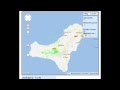
- AVCAN has mapped the quakes reported by the IGN (see below). The violet bullet the M3.4 of today, the red bullets are todays earthquakes (38), the green bullets those of yesterday (16) and the yellow bullets the 120 quakes from June 1 to June 23.

[ Bericht 9% gewijzigd door bwt op 25-06-2012 13:44:32 ]
<a href="http://goo.gl/q8fhTe" target="_blank">FAQ?</a>
<a href="http://goo.gl/gYvZFq" target="_blank">Geel is een zonnige en vrolijke kleur, als hij tenminste enigszins warm is gekleurd en wat naar het oranje neigt</a>
<a href="http://goo.gl/gYvZFq" target="_blank">Geel is een zonnige en vrolijke kleur, als hij tenminste enigszins warm is gekleurd en wat naar het oranje neigt</a>
quote:Update 25/06 – 12:39 UTC
- Another strong earthquake occurred at 12:13 UTC. We do not know the location yet as it was not listed yet by IGN.
- The epicenters of the last sets of earthquakes (those listed by IGN) is gradually shifting towards the submarine Las Calmas vent.
- We consider this as the best possible scenario for a new eruption as the submarine vent is located at a safe distance out of the coast.
- So far 71 earthquakes have been listed, but there are much more earthquakes than those listed. Not only the most recent ones, but also those below M2.0 which have to be considered volcanic earthquakes too. In the initial reporting, these weaker earthquakes were also listed by IGN in a text format list, but IGN stopped publishing these (on political pressure ?)
- One particular listed earthquake attracted our attention and maybe a trace of what is coming :
The 10:25 M2.6 earthquake to the SW of El Pinar at a depth of 11 km. The shallower depth may indicate that the magma has arrived in the earlier open lava tube system below the shallow cone.
Update 25/06 – 12:01 UTC
- Another (not yet listed) strong earthquake occurred at 11:19 UTC. We expect it to be measuring in between M3.2 and M3.6
Update 25/06 – 11:42 UTC
- An M3.0 earthquake occurred out of the Tenerife coast but cannot be seen as directly related to the El Hierro activity.
- As ER is following earthquakes worldwide, we noticed some earthquake activity in the greater Azores area about 15 minutes prior to the activity of El Hierro. A direct relation is of course impossible to prove, but we simply noticed it.
Bevingen lijken inmiddels ook weer af te nemen.
Gezien de statistieken en grafiekjes lijkt alles weer tot rust te komen.
Maar ja, je weet nooit wat een vulkaan doet......
[ Bericht 35% gewijzigd door bwt op 25-06-2012 22:34:34 ]

Gezien de statistieken en grafiekjes lijkt alles weer tot rust te komen.
Maar ja, je weet nooit wat een vulkaan doet......
quote:Update 25/06 18:12 UTC Pevolca press report (Gobierno de Canarias)
To most people, the decision of Pevolca will come as a surprise no special precautions whatsoever, not even at El Julan where most of the earthquakes are centering now.
The Pevolca decision is however motivated by the lack of deformation of the island, by the depth of the earthquakes and by the lack of gas emissions. 20 km is ok for IGN and INVOLCAN (scientific partners in Pevolca).
The press report is also stating that IGN is following up the earthquakes in Realtime (not 2 hours behind schedule like they do with the public). Lets hope IGN and PEVOLCA have taken the right decision. We have to stress that they have been always right so far.
Lets make however an important remark : the route towards the traditional submarine cone seems still to be blocked and we still have earthquake close to M3 going on. If a major M+4 occurs, all scenarios are open.
Update 25/06 18:55 UTC
- Seismicity is calming considerably the last couple of hours. It seems that the volcano has listened to the Pevolca board .
- 121 M+2 earthquakes until 17:37 UTC today (149 total M+1.4) (This does not take into account the probably hundreds of earthquakes below M1.4 which were registered in 2011, but are only visible now for the IGN and INVOLCAN volcanologists).
[ Bericht 35% gewijzigd door bwt op 25-06-2012 22:34:34 ]
<a href="http://goo.gl/q8fhTe" target="_blank">FAQ?</a>
<a href="http://goo.gl/gYvZFq" target="_blank">Geel is een zonnige en vrolijke kleur, als hij tenminste enigszins warm is gekleurd en wat naar het oranje neigt</a>
<a href="http://goo.gl/gYvZFq" target="_blank">Geel is een zonnige en vrolijke kleur, als hij tenminste enigszins warm is gekleurd en wat naar het oranje neigt</a>
Vandaag een stuk rustiger:
Wordt voornamelijk verorzaakt doordat de Harmonic tremmor weg is gevallen. De lava stroom wordt tegen gehouden. Maar er is nog wel voldoende druk.
Gaat deze druk de blokkade in de lavatunnels wegwerken? Of is het sterk genoeg om de lava tegen te houden?
[ Bericht 37% gewijzigd door bwt op 26-06-2012 13:32:49 ]

Wordt voornamelijk verorzaakt doordat de Harmonic tremmor weg is gevallen. De lava stroom wordt tegen gehouden. Maar er is nog wel voldoende druk.
Gaat deze druk de blokkade in de lavatunnels wegwerken? Of is het sterk genoeg om de lava tegen te houden?
quote:Update 26/06 11:07 UTC
- 89 earthquakes so far today (IGN is still adding continuously).
- The location of the epicenter remains below the island and the hypocenter behave normal (18 20 km).
- The stronger earthquakes are in the M2.9 to M3.1 range. Most of the earthquakes are stronger than M2.0.
Important Update 26/06 10:30 UTC
- What looks in the seismogram as being a lot less activity than yesterday is not completely true as only the Harmonic Tremor (magma flow) has almost stopped completely. The accumulated pressure of the magma below the island is still very strong.
- Until 08:42 UTC, 77 earthquakes have been listed by IGN (M1.3 or stronger)
Joke Volta told us that she had felt the M2.9 which occurred this morning at 04:10 near El Pinar (05:10 local time). Joke lives in El Pinar. The IGN list, which is set up manually by IGN staff and is only published 2 hours after occurrence of the earthquakes, does not show a depth of this earthquake NOR does it show that this particular earthquake was felt by the people. Even more strange is that the depth of this earthquake has been plotted as EXTREMELY SHALLOW by the IGN plotted version of the quakes (see below). Why not mentioning the depth in the main list ? Are the values unsure ? The strength was strong enough to locate the depth (with an eventual error margin). We understand that a single shallow quake is not enough to be conclusive, but hiding information is from the past century.

[ Bericht 37% gewijzigd door bwt op 26-06-2012 13:32:49 ]
<a href="http://goo.gl/q8fhTe" target="_blank">FAQ?</a>
<a href="http://goo.gl/gYvZFq" target="_blank">Geel is een zonnige en vrolijke kleur, als hij tenminste enigszins warm is gekleurd en wat naar het oranje neigt</a>
<a href="http://goo.gl/gYvZFq" target="_blank">Geel is een zonnige en vrolijke kleur, als hij tenminste enigszins warm is gekleurd en wat naar het oranje neigt</a>
Vannacht een aantal boven de 3.0
1151707 27/06/2012 02:27:12 27.6950 -18.1128 20 Sentido 3.4 mbLg SW FRONTERA.IHI
1151677 27/06/2012 00:11:27 27.7106 -18.0918 19 Sentido 3.4 mbLg SW FRONTERA.IHI
1151672 26/06/2012 23:44:52 27.7026 -18.0975 19 Sentido 3.3 mbLg SW FRONTERA.IHI
1151643 26/06/2012 21:43:11 27.6873 -18.0896 20 Sentido 3.1 mbLg W EL PINAR.IHI
En de bevingen lijken nu verder zuidwaards te trekken.
Maar de tremor opleving van gisteravond/nacht was slechts van korte duur.


<a href="http://goo.gl/q8fhTe" target="_blank">FAQ?</a>
<a href="http://goo.gl/gYvZFq" target="_blank">Geel is een zonnige en vrolijke kleur, als hij tenminste enigszins warm is gekleurd en wat naar het oranje neigt</a>
<a href="http://goo.gl/gYvZFq" target="_blank">Geel is een zonnige en vrolijke kleur, als hij tenminste enigszins warm is gekleurd en wat naar het oranje neigt</a>
Hier zal nog wel het een en ander gaan uitkomen. Met zo veel bevingen en blijkbaar hoge druk van het magma. Het mooiste is natuurlijk als de opening naar de eerste "vent" op -80 meter gevonden gaat worden.
Huidige bevingen trekken verder naar het westen lijkt het - niet naar het zuiden.
Is ook mooi te vergelijken met de tekening met bevingen vanaf 1-1-2012
Alles moet nog verdere omhoog komen en verder naar het zuiden voordat we ook maar kunnen hopen/denken op/aan een vervolg van de eruptie.

Is ook mooi te vergelijken met de tekening met bevingen vanaf 1-1-2012

Alles moet nog verdere omhoog komen en verder naar het zuiden voordat we ook maar kunnen hopen/denken op/aan een vervolg van de eruptie.
<a href="http://goo.gl/q8fhTe" target="_blank">FAQ?</a>
<a href="http://goo.gl/gYvZFq" target="_blank">Geel is een zonnige en vrolijke kleur, als hij tenminste enigszins warm is gekleurd en wat naar het oranje neigt</a>
<a href="http://goo.gl/gYvZFq" target="_blank">Geel is een zonnige en vrolijke kleur, als hij tenminste enigszins warm is gekleurd en wat naar het oranje neigt</a>
quote:DISCLOSURE NOTICE INVOLCAN:
Urgently inform the records of the observed shift of the GPS network Canaria (Nagoya Univ ITER + + GRAFCAN) operating Volcanic Canary Island Institute under the direction of Dr. Takeshi Sagiya (Professor of Nagoya University and Scientific Collaborator INVOLCAN .)
GPS STATION PINA (El Pinar)
During the last 2 days there has been horizontal eastward displacement of 3 cm and north of 1.5 cm and a displacement in the vertical (elevation) of 3 cm.
These deformation data clearly reflect a process of movement of magma underground and the source responsible for this deformation is in the central-western part of the island of El Hierro in conjunction with data from recent seismic activity.
The movements recorded during the last 2 days are real and much faster than those observed last year 2011.


En ER laat meer weten over deformatie
quote:Update 27/06 09:58 UTC
- Deformations, as described in the Involcan maps and report below, are generated by the Magma pressure and are one of the major indications to predict eruptions. Together with the strength of the earthquakes, the depth of the hypocenters and the emitted gases, they are used by volcanologists to send alerts and warnings to the public. The mitted gases are the uncertain factor in this case but didnt we hear a couple of months ago that some sampling points were dismantled ?
- The Involcan informative note is a real blame to the IGN and PEVOLCA communications policy. These organizations should review their communication policy urgently. We live in 2012 and when people feel the earth shaking almost constantly like in Sabinosa, you cannot get away with a message that the state of the island is normal, even if this is scientifically true. We know that we are repeating ourselves over and over again but the present situation becomes hallucinate.
quote:DISCLOSURE NOTICE INVOLCAN:
In the attached graph can observe the number of earthquakes above magnitude 2.5 have occurred since last year, thus covering the entire period of the process that is lived on the island of El Hierro. As you can see, in these last 48 hours the records of these earthquakes per day outnumber (enventos every 24 hours) than those recorded during the past year, which speaks of the power capacity of the process that is occurring now up on the island. So far identified 92 such events on 25 and 87 on 26.

En weer een 3+
1151907 27/06/2012 10:55:07 27.6980 -18.1066 20 Sentido 3.2 mbLg SW FRONTERA.IHI


[ Bericht 3% gewijzigd door bwt op 27-06-2012 14:32:21 ]
<a href="http://goo.gl/q8fhTe" target="_blank">FAQ?</a>
<a href="http://goo.gl/gYvZFq" target="_blank">Geel is een zonnige en vrolijke kleur, als hij tenminste enigszins warm is gekleurd en wat naar het oranje neigt</a>
<a href="http://goo.gl/gYvZFq" target="_blank">Geel is een zonnige en vrolijke kleur, als hij tenminste enigszins warm is gekleurd en wat naar het oranje neigt</a>
twitter:teideano twitterde op woensdag 27-06-2012 om 14:53:08 @eruptionsblog @rschott @Suw @Lumifg @pabloj_gonzalez @emsc @CPPGeophysics http://t.co/CFoOv2z8 Yellow alert at El Hierro reageer retweet
 @eruptionsblog @
Het bijbehorende plaatje mag niet zonder toestemming gebruikt worden - daarom ook de link in het verhaal er naar toe.quote:DISCLOSURE NOTICE INVOLCAN
This image shows the evolution of the moving average daily flow of carbon dioxide diffuse registered in the ITER HIE01 geochemical station and the daily number of earthquakes located by the national seismic network of ign. The data recorded in the HIE01 until Wednesday June 27th, 2012 at 08:00 am show relatively low values (average of 4 grams of carbon dioxide per square meter per day). Also you can see a pulse on the diffuse flux of carbon dioxide recorded from April 7 to May 20, 2012 that could be interpreted as a possible precursor signal of the recent seismic activity-strain that is being registered in El Hierro. It allows you to share this information but do not allow the dissemination and reproduction of this image without permission of INVOLCAN.
quote:Important Update 27/06 12:32 UTC
Pevolca calls a Yellow alert in the unpopulated earthquake zone. In a live interview on RTVC, the local Canary Island TV and Radio station, María josé jurado has declared that the El Julan and La Dehesa area will be labeled as Yellow Alert area. Besides a church and a lighthouse, this area is unpopulated.
The move sounds logic to ER as the direct treat to other areas for eventual earthquake damage is very limited. Earthquakes are the main risk at this moment.

twitter:eruptionsblog twitterde op woensdag 27-06-2012 om 15:39:48 Alert status raised to "Yellow" for parts of El Hierro as seismicity and carbon dioxide emissions continue to increase: http://t.co/lp9BND5t reageer retweet
 Alert status raised to "Yellow" for parts of El Hierro as seismicity and carbon dioxide emissions continue to increase:
 .twitter:canariesnews twitterde op woensdag 27-06-2012 om 15:45:25 Alert level raised to 'yellow' on El Hierro due to recent seismic activity - http://t.co/pxkbo2qc reageer retweet
 Alert level raised to 'yellow' on El Hierro due to recent seismic activity -
 kortom - het gaat hard vandaag
[ Bericht 26% gewijzigd door bwt op 27-06-2012 15:48:24 ]
<a href="http://goo.gl/q8fhTe" target="_blank">FAQ?</a>
<a href="http://goo.gl/gYvZFq" target="_blank">Geel is een zonnige en vrolijke kleur, als hij tenminste enigszins warm is gekleurd en wat naar het oranje neigt</a>
<a href="http://goo.gl/gYvZFq" target="_blank">Geel is een zonnige en vrolijke kleur, als hij tenminste enigszins warm is gekleurd en wat naar het oranje neigt</a>
quote:Update 27/06 – 16:36 UTC
Almost all the recent earthquake’s epicenters are gradually migrating south into the Las Calmas sea. The denomination ” SW FRONTERA” are gradually replaced by “W EL PINAR” when the epicenter is located in the Las Calmas sea.
The migration to the new area can also be observed in the existence of harmonic tremor which started also around 14:00 UTC.
It looks now that HT is diminishing again and that the earthquakes will remain in the same area until new HT appears (possibly started by some strong earthquakes).

<a href="http://goo.gl/q8fhTe" target="_blank">FAQ?</a>
<a href="http://goo.gl/gYvZFq" target="_blank">Geel is een zonnige en vrolijke kleur, als hij tenminste enigszins warm is gekleurd en wat naar het oranje neigt</a>
<a href="http://goo.gl/gYvZFq" target="_blank">Geel is een zonnige en vrolijke kleur, als hij tenminste enigszins warm is gekleurd en wat naar het oranje neigt</a>
En de volgende
1152007 27/06/2012 18:55:08 27.6883 -18.1006 20 Sentido 4.0 4 W EL PINAR.IHI

1152007 27/06/2012 18:55:08 27.6883 -18.1006 20 Sentido 4.0 4 W EL PINAR.IHI

quote:Update 27/06 – 19:45 UTC
The earthquakes epicenters are currently located at the same area where it all started on September 27, 2011. The depth at that time was approx. 15 to 17 km. The current depth is more in the 19 to 21 km range . The difference in between the 2 layers is a couple of kms. (All our readers can come to the same conclusion in comparing the location and the depth of the 10 days of earthquakes who started on September 27 and todays location of the quakes). All this is not conclusive in what will happen next.
Update 27/06 – 19:01 UTC
Joke has just SMS’t (texted) that she has felt a strong shock in El Pinar.
The earthquake Joke has just reported was a M4.0, the strongest earthquake since last year.
As you will be seeing on the map, the epicenter is located below the Las Calmas sea floor.
18:55:08 27.6883 -18.1006 Depth 20 km Sentido M 4.0 mbLg W EL PINAR
<a href="http://goo.gl/q8fhTe" target="_blank">FAQ?</a>
<a href="http://goo.gl/gYvZFq" target="_blank">Geel is een zonnige en vrolijke kleur, als hij tenminste enigszins warm is gekleurd en wat naar het oranje neigt</a>
<a href="http://goo.gl/gYvZFq" target="_blank">Geel is een zonnige en vrolijke kleur, als hij tenminste enigszins warm is gekleurd en wat naar het oranje neigt</a>
En de actie van/voor vandaag

<a href="http://goo.gl/q8fhTe" target="_blank">FAQ?</a>
<a href="http://goo.gl/gYvZFq" target="_blank">Geel is een zonnige en vrolijke kleur, als hij tenminste enigszins warm is gekleurd en wat naar het oranje neigt</a>
<a href="http://goo.gl/gYvZFq" target="_blank">Geel is een zonnige en vrolijke kleur, als hij tenminste enigszins warm is gekleurd en wat naar het oranje neigt</a>
dat lijkt toch weer redelijk watquote:
Inorbit: zeg dat dan typluie triangeljosti
Beauregard: Een beetje FOK!ker laat het brood door z'n moeder smeren.
Ecosia
ek's 'n flash drive, jy's 'n floppy
Beauregard: Een beetje FOK!ker laat het brood door z'n moeder smeren.
Ecosia
ek's 'n flash drive, jy's 'n floppy

ook daar gaat het lekker!
Inorbit: zeg dat dan typluie triangeljosti
Beauregard: Een beetje FOK!ker laat het brood door z'n moeder smeren.
Ecosia
ek's 'n flash drive, jy's 'n floppy
Beauregard: Een beetje FOK!ker laat het brood door z'n moeder smeren.
Ecosia
ek's 'n flash drive, jy's 'n floppy
Of te wel.... De Harmonic Tremor is terug (voor zo lang het duurt) Dit betekend dat de lava weer verder aan het oprukken is. Waarschijnlijk zullen de volgende bevingen weer verder naar het zuiden gaan optreden.
Ben benieuwd.....
Ben benieuwd.....
<a href="http://goo.gl/q8fhTe" target="_blank">FAQ?</a>
<a href="http://goo.gl/gYvZFq" target="_blank">Geel is een zonnige en vrolijke kleur, als hij tenminste enigszins warm is gekleurd en wat naar het oranje neigt</a>
<a href="http://goo.gl/gYvZFq" target="_blank">Geel is een zonnige en vrolijke kleur, als hij tenminste enigszins warm is gekleurd en wat naar het oranje neigt</a>