WKN Weer, Klimaat en Natuurrampen
Lees alles over het onstuimige weer op onze planeet, volg orkanen en tornado's, zie hoe vulkanen uitbarsten en hoe Moeder Aarde beeft bij een aardbeving. Alles over de verwoestende kracht van onze planeet en tal van andere natuurverschijnselen.


Typhoon ROKE
Typhoon ROKE is momenteel op ramkoers met Japan. Met een windsnelheid van rond de 210 km/uur en windstoten tot ongeveer 260 km/uur trekt deze eerst nog langs het zuidelijke deel van het eiland om vervolgens dichtbij Tokyo aan landfall te maken. Inmiddels zijn er al overstromingen en zijn er miljoenen mensen geevacueerd.
Aan het oog en de dichte structuur van de orkaan is al te zien dat het een hoge categorie is.
Zie ook: Hurricane Season 2011 # 3
Typhoon ROKE is momenteel op ramkoers met Japan. Met een windsnelheid van rond de 210 km/uur en windstoten tot ongeveer 260 km/uur trekt deze eerst nog langs het zuidelijke deel van het eiland om vervolgens dichtbij Tokyo aan landfall te maken. Inmiddels zijn er al overstromingen en zijn er miljoenen mensen geevacueerd.
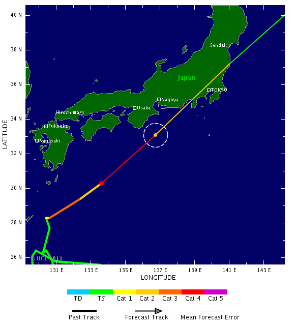
Aan het oog en de dichte structuur van de orkaan is al te zien dat het een hoge categorie is.
Youtube filmpjes.quote:Miljoen Japanners op de vlucht voor tyfoon Roke
De Japanse autoriteiten hebben zo'n 1,3 miljoen burgers de raad gegeven hun huizen onmiddellijk te verlaten. De tyfoon Roke is op weg naar het vasteland, en zijn doortocht dreigt gepaard te gaan met enorme hoeveelheden regen en hevige windstoten.
Nu al veroorzaakt de regen overstromingen. Onder meer de iets meer dan een miljoen inwoners van de stad Nagoya hebben de raad gekregen hun huis te ontvluchten. Er zou tot 50 millimeter regen in één uur kunnen vallen.
Roke is de 15de tyfoon dit jaar die Japan teistert. Begin deze maand was er nog Talas, waarvan de doortocht bijna honderd doden en vermisten maakte, voornamelijk in het westen van het land. (belga/gb)
hln


Zie ook: Hurricane Season 2011 # 3


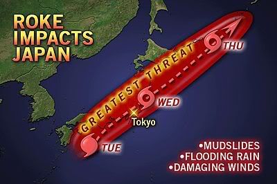
Typhoon Roke Forcing Mass Evacuations in Japan
Dangerous Typhoon Roke, now the equivalent of a Category 4 hurricane, is set to be the strongest typhoon to hit Japan so far this year.
Though the typhoon is expected to weaken some before roaring onshore over south-central Honshu Wednesday, it will unleash life-threatening flooding rain and mudslides. Near the point of landfall, wind damage could be severe.
Tokyo and areas that were devastated by the massive earthquake and tsunami earlier this year will be affected.
Between 6 and 10 inches (150 to 250 mm) of rain is predicted to inundate places from Fukushima on north through northeastern Honshu, perhaps including Sendai, according to AccuWeather.com Expert International Forecaster Jim Andrews.
Officials have already advised or ordered nearly 1.2 million people in central and western Japan to evacuate, reported NHK World. The majority of those evacuation orders and advisories have been for the city of Nagoya, which has already picked up roughly 9 inches (230 mm) of rain ahead of the typhoon.
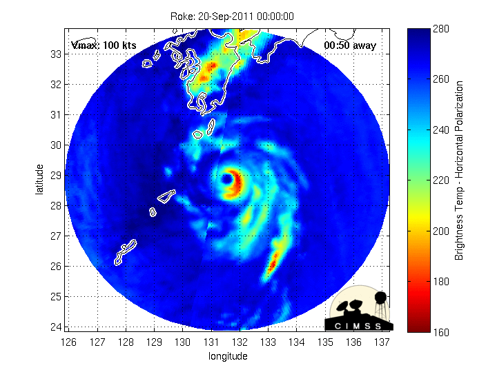
As of Tuesday evening local time (late Tuesday morning EDT), Roke was located off the southern coast of Japan's main island, Honshu, several hundred miles southwest of Tokyo. Maximum winds were at 130 mph (210 kph), making the typhoon the equivalent of an extremely dangerous Category 4 hurricane.
Roke may weaken Tuesday night into early Wednesday before plowing into the south-central portion of Honshu Wednesday afternoon local time (early Wednesday morning EDT). The eye of the storm is expected to pass between Tokyo and Nagoya.
AccuWeather.com Tropical Expert Dan Kottlowski expects the storm to make landfall as the equivalent of a strong Category 1 or Category 2 hurricane.
Wind gusts at landfall will range between 100 and 120 mph (160 and 190 kph) along the coast between Nagoya and Tokyo, according to Andrews. Typhoon-force gusts of 70 to 90 mph (110 to 145 kph) are possible in Tokyo by Wednesday afternoon.
Flight cancellations are a given for Tokyo's bustling international airports, if they are not shut down entirely.
"Winds will cause at least moderate damage along and near the direct path of Roke," stated Andrews. If Roke maintains its current track, Tokyo will fall in the northeastern quadrant of the storm, where winds are typically the strongest and rain is commonly the heaviest.
Once inland, Roke will weaken substantially. However, the threat for life-threatening flooding rain and mudslides will continue as it cuts across the middle of Japan, nearing the northeastern part of Honshu, which was devastated by earthquake and tsunami in March.
"Workers trying to control leakage into the basements of nuclear reactors at the Fukushima Daiichi power plant may need to be evacuated ahead of the storm, with more than 6 inches of rain expected to fall over the reeling prefecture," warned AccuWeather.com meteorologist Bill Deger.
As of Tuesday evening local time (late Tuesday morning EDT), more than 16 inches (400 mm) of rain has fallen in the southern province of Miyazaki, which lies west of the storm's center. Nearly 13 inches (330 mm) has inundated Tokushima on the island of Shikoku.
With similar rainfall totals projected for Nagoya, there is a major concern for mudslides and flooding along a main river in that area.
Bron: Accuweather
Dangerous Typhoon Roke, now the equivalent of a Category 4 hurricane, is set to be the strongest typhoon to hit Japan so far this year.
Though the typhoon is expected to weaken some before roaring onshore over south-central Honshu Wednesday, it will unleash life-threatening flooding rain and mudslides. Near the point of landfall, wind damage could be severe.
Tokyo and areas that were devastated by the massive earthquake and tsunami earlier this year will be affected.
Between 6 and 10 inches (150 to 250 mm) of rain is predicted to inundate places from Fukushima on north through northeastern Honshu, perhaps including Sendai, according to AccuWeather.com Expert International Forecaster Jim Andrews.
Officials have already advised or ordered nearly 1.2 million people in central and western Japan to evacuate, reported NHK World. The majority of those evacuation orders and advisories have been for the city of Nagoya, which has already picked up roughly 9 inches (230 mm) of rain ahead of the typhoon.
As of Tuesday evening local time (late Tuesday morning EDT), Roke was located off the southern coast of Japan's main island, Honshu, several hundred miles southwest of Tokyo. Maximum winds were at 130 mph (210 kph), making the typhoon the equivalent of an extremely dangerous Category 4 hurricane.
Roke may weaken Tuesday night into early Wednesday before plowing into the south-central portion of Honshu Wednesday afternoon local time (early Wednesday morning EDT). The eye of the storm is expected to pass between Tokyo and Nagoya.
AccuWeather.com Tropical Expert Dan Kottlowski expects the storm to make landfall as the equivalent of a strong Category 1 or Category 2 hurricane.
Wind gusts at landfall will range between 100 and 120 mph (160 and 190 kph) along the coast between Nagoya and Tokyo, according to Andrews. Typhoon-force gusts of 70 to 90 mph (110 to 145 kph) are possible in Tokyo by Wednesday afternoon.
Flight cancellations are a given for Tokyo's bustling international airports, if they are not shut down entirely.
"Winds will cause at least moderate damage along and near the direct path of Roke," stated Andrews. If Roke maintains its current track, Tokyo will fall in the northeastern quadrant of the storm, where winds are typically the strongest and rain is commonly the heaviest.
Once inland, Roke will weaken substantially. However, the threat for life-threatening flooding rain and mudslides will continue as it cuts across the middle of Japan, nearing the northeastern part of Honshu, which was devastated by earthquake and tsunami in March.
"Workers trying to control leakage into the basements of nuclear reactors at the Fukushima Daiichi power plant may need to be evacuated ahead of the storm, with more than 6 inches of rain expected to fall over the reeling prefecture," warned AccuWeather.com meteorologist Bill Deger.
As of Tuesday evening local time (late Tuesday morning EDT), more than 16 inches (400 mm) of rain has fallen in the southern province of Miyazaki, which lies west of the storm's center. Nearly 13 inches (330 mm) has inundated Tokushima on the island of Shikoku.
With similar rainfall totals projected for Nagoya, there is a major concern for mudslides and flooding along a main river in that area.
Bron: Accuweather

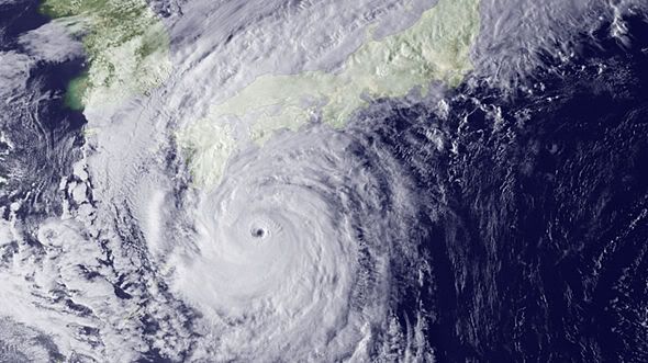
bron: Wundergroundquote:Powerful Category 3 Typhoon Roke is bearing down on Japan, and is expected to hit the main island of Honshu on Wednesday morning, local time. Roke is on a dangerous track for Japan, one that would take the storm over some of the most heavily populated areas of the country. Heavy rains from Roke have already reached the coast of Japan, as seen on Japanese radar. However, Roke is starting to weaken, as seen in latest satellite imagery. The eye is no longer apparent, the cloud tops have warmed, and a slot of dry air has gotten wrapped into the storm's northwest side. Wind shear should continue to weaken Roke as it approaches landfall; shear is currently a high 20 knots, and will increase to 30 knots by Wednesday morning. Given the current weakening trend, I expect Roke is most likely to be a Category 2 typhoon at landfall.
Typhoon's Roke's storm surge, winds, and heavy rains will all be a concern. A damaging storm surge is likely to the right of where the center makes landfall, since Roke is a large storm whose winds are spread out over a wide area. If Roke tracks farther to the east than expected, a large storm surge may affect Tokyo Bay. Perhaps the biggest concern from the storm is heavy rain. The soils over much of Japan are saturated from the passage of Tropical Storm Talas during the first week of September. Talas was a very slow moving storm, and brought extreme rainfall amounts of over six feet to some portions of Japan. Roke is expected to bring up to 20 more inches of rain along its path. Roke could bring winds of 30 - 40 mph and heavy rains of 3 - 5 inches to the damaged Fukishima-Dai-Iche nuclear plant northeast of Tokyo.
Op WW had ik al gezegd dat het een cat 2 landfall zou worden 
Doe mee met het voorspellen van het weer!
Weekvoorspelling | Week 12 (invullen tot 16-03 - 11:59)
Maandvoorspelling Maart (Inzendingen gesloten)
Jaarvoorspelling 2025 / 2026
Weekvoorspelling | Week 12 (invullen tot 16-03 - 11:59)
Maandvoorspelling Maart (Inzendingen gesloten)
Jaarvoorspelling 2025 / 2026

Het was ook wel duidelijk dat het een cat 2 zou worden bij landfall. Dat gaf de voorspelling ook aan.quote:Op woensdag 21 september 2011 09:32 schreef SpeedyGJ het volgende:
Op WW had ik al gezegd dat het een cat 2 landfall zou worden
Tyfoon Roke eist vier mensenlevens in Japan
De tyfoon Roke heeft vandaag de Japanse kust bereikt ter hoogte van de centraal gelegen prefectuur Shizuoka. Dat meldt het Japanse meteorologische agentschap. Bij de doortocht, die gepaard gaat met windstoten tot meer dan 200 kilometer per uur en stortbuien, vielen al vier doden. Twee mensen worden vermist.
De slachtoffers vielen in het centrum en het westen van het land. Een kind dat terugkeerde van school, is vermist.
De autoriteiten waarschuwden de voorbije twee dagen de bevolking meermaals voor de tyfoon die de dichtstbevolkte gebieden van Japan - de centrale agglomeratie van Nagoya, de provincie Shizuoka en de hoofdstad Tokio - vandaag zou kunnen treffen.
Overstromingen
Intussen waren er al overstromingen in de prefectuur Aichi, het industriële hart van het centrum van Japan, waar de autoriteiten de meer dan een miljoen inwoners de raad gaven hun huis te verlaten.
De tyfoon dwong de autobouwer Toyota de productie in elf van de vijftien Japanse fabrieken stil te leggen. Verschillende autowegen zijn gesloten en meer dan tweehonderd vluchten werden al geschrapt.
Risico op grondverschuivingen
Roke zou opnieuw tot grondverschuivingen kunnen leiden in de prefectuur Wakayama, in het centrum-westen van het land, die begin september al getroffen werd door de tyfoon Talas. Toen kwamen bijna honderd mensen om.
Ook zou het natuurgeweld passeren boven de regio van Tohoku, in het noordoosten, waarvan de kust verwoest werd door de aardbeving en de tsunami op 11 maart. Boven de zwaar beschadigde kerncentrale van Fukushima, waar de bergingswerken voortgaan, zal het hevig regenen. (afp/eb)
hln
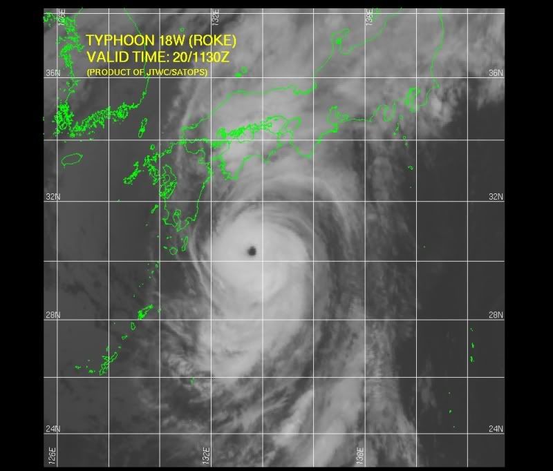
Prachtige satellietafbeelding van tyfoon Roke


Weer of geen weer, altijd actueel www.onweer-online.nl

quote:Roke trekt spoor van vernieling door Japan
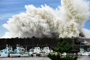
De tyfoon Roke heeft een spoor van vernieling getrokken door Japan. Ook de hoofdstad Tokio kreeg de volle laag. Bij de doortocht, die gepaard ging met windstoten tot meer dan 220 kilometer per uur en stortbuien, vielen al minstens vijf doden. Twee mensen worden vermist. De slachtoffers vielen in het centrum en het westen van het land. Een kind dat terugkeerde van school, is vermist. De regen viel met bakken uit de lucht: tot 40 cm neerslag in enkele uren tijd. Honderdduizenden huizen en ook heel wat bedrijven en fabrieken kwamen zonder stroom te zitten. Ook het (lucht)verkeer geraakte grondig verstoord. Enkele megagolven teisterden de Japanse kust. Later op de dag zette de 'killertyfoon' koers richting het noordoosten van Japan, waar in het voorjaar een aardbeving en tsunami een nooit geziene verwoesting aanrichtte. Ook de gehavende kerncentrale van Fukushima werd bedreigd door Roke.
De autoriteiten waarschuwden de voorbije twee dagen de bevolking meermaals voor de tyfoon die de dichtstbevolkte gebieden van Japan - de centrale agglomeratie van Nagoya, de provincie Shizuoka en de hoofdstad Tokio - vandaag zou kunnen treffen. Tokio kreeg de volle laag. Er sneuvelde onder meer een grote boom.
Waterpeil
De grootste angst van de autoriteiten betrof de kerncentrale van Fukushima, die ook geteisterd werd door de killertyfoon. De nucleaire site heeft grote hoeveelheden water in de reactors gegoten na de meltdowns om de reactors te koelen. In het geval van een overstroming zou radioactief water in zee kunnen stromen. Uiteindelijk bleef de kerncentrale gespaard van verder onheil. De bergingswerken na de aardbeving en tsunami van 11 maart zijn nog altijd aan de gang in rond Fukushima. De kerncentrale werd tijdens de storm in de gaten gehouden met de hulp van camera's.
Overstromingen
Intussen waren er al overstromingen in de prefectuur Aichi, het industriële hart van het centrum van Japan, waar de autoriteiten de meer dan een miljoen inwoners de raad gaven hun huis te verlaten. De tyfoon dwong de autobouwer Toyota de productie in elf van de vijftien Japanse fabrieken stil te leggen. Ook Nissan Motor en Mitsubishi Heavy Industries werd getroffen door de 'power cut'. Ook het verkeer raakte grondig in de war. Verschillende autowegen zijn gesloten en meer dan 450 vluchten werden al geschrapt.
Risico op grondverschuivingen
Roke zou opnieuw tot grondverschuivingen kunnen leiden in de prefectuur Wakayama, in het centrum-westen van het land, die begin september al getroffen werd door de tyfoon Talas. Toen kwamen bijna honderd mensen om.
|
|