WKN Weer, Klimaat en Natuurrampen
Lees alles over het onstuimige weer op onze planeet, volg orkanen en tornado's, zie hoe vulkanen uitbarsten en hoe Moeder Aarde beeft bij een aardbeving. Alles over de verwoestende kracht van onze planeet en tal van andere natuurverschijnselen.


Of weer zo'n Berlusconi-feestje..quote:
And what rough beast, its hour come round at last,
Slouches towards Bethlehem to be born?
Slouches towards Bethlehem to be born?

quote:Op donderdag 3 november 2011 16:27 schreef Perrin het volgende:
[..]
Of weer zo'n Berlusconi-feestje..
Er gingen schokken door Italie toen bleek dat Griekenland uit de Euro stapte en Italie niet meer aan zijn betalingsverplichtingen kan voldoen
quote:Meer dan 780.000 doden door aardbevingen laatste 10 jaar
Bij aardbevingen zijn het voorbije decennium, rechtstreeks of onrechtstreeks, meer dan 780.000 doden gevallen. Daar komt bij dat tussen 2001 en 2010 nog eens twee miljard mensen rechtstreeks werden getroffen door aardbevingen. Dat blijkt uit een studie van The Lancet. Aardbevingen zijn goed voor bijna 60 procent van de doden die vallen bij natuurrampen.
Het onderzoek heeft als doel vooral politieke functionarissen en hulpinstanties te doen beseffen dat aardbevingen een prioriteit zijn inzake openbare gezondheid. Dokters moet het een beeld geven van de pathologieën waarmee ze bij dergelijke rampen zullen geconfronteerd worden.
De meest moordende aardbeving van het voorbije decennium was die op Haïti van 12 januari 2010, met 316.000 slachtoffers. De zeebeving die een tsunami veroorzaakte in de Indische Oceaan op 26 december 2004 kostte het leven aan 227.000 mensen. Op de derde plaats staat de aardbeving in de Chinese provincie Sichuan van 12 mei 2008, waar de teller op 87.500 doden stond.
Kinderen zijn de meest kwetsbare groep. Zij maken 25 tot 53 procent van de patiënten uit na een aardbeving.
Met de groei van de wereldbevolking en de uitbreiding van het stedelijk gebied naar risicozones zal de dreiging van aardbevingen de komende jaren nog toenemen, waarschuwen de auteurs van de studie. (belga/sps)
quote:
GUARANTEED!!!!quote:Quakeprediction Earthquake Forecasts
A 5.6+ earthquake is guaranteed to hit the Berkeley or San Jose area in the next 53 hours. Please be preparedextra food, gas, cash.

5.6 bij Oklahoma...
misschien bedoelde hij die
misschien bedoelde hij die

quote:MAP 3.7 2011/11/06 17:52:34 35.547 -96.819 5.0 OKLAHOMA
MAP 3.9 2011/11/06 15:07:05 35.535 -96.909 5.0 OKLAHOMA
MAP 3.2 2011/11/06 11:20:23 35.525 -96.883 5.0 OKLAHOMA
MAP 3.0 2011/11/06 11:16:20 35.523 -96.844 4.9 OKLAHOMA
MAP 3.4 2011/11/06 11:03:52 35.539 -96.825 5.0 OKLAHOMA
MAP 3.9 2011/11/06 10:52:35 35.567 -96.797 5.0 OKLAHOMA
MAP 4.0 2011/11/06 09:39:57 35.506 -96.865 5.0 OKLAHOMA
MAP 3.4 2011/11/06 09:22:04 35.585 -96.823 5.0 OKLAHOMA
MAP 2.7 2011/11/06 08:14:12 35.474 -96.794 5.0 OKLAHOMA
MAP 3.2 2011/11/06 07:32:40 35.544 -96.901 4.9 OKLAHOMA
MAP 3.8 2011/11/06 06:31:10 35.559 -96.874 5.0 OKLAHOMA
MAP 3.0 2011/11/06 04:54:00 35.540 -96.687 5.0 OKLAHOMA
MAP 3.6 2011/11/06 04:03:41 35.554 -96.760 5.0 OKLAHOMA
MAP 5.6 2011/11/06 03:53:10 35.537 -96.747 5.0 OKLAHOMA
MAP 3.6 2011/11/05 14:36:30 35.584 -96.789 4.9 OKLAHOMA
MAP 3.4 2011/11/05 13:42:26 35.530 -96.766 5.0 OKLAHOMA
MAP 3.3 2011/11/05 11:24:15 35.521 -96.778 5.0 OKLAHOMA
MAP 3.3 2011/11/05 09:12:11 35.591 -96.788 4.9 OKLAHOMA
MAP 2.7 2011/11/05 07:50:42 35.559 -96.762 4.8 OKLAHOMA
MAP 2.7 2011/11/05 07:44:34 35.488 -96.755 5.0 OKLAHOMA
MAP 3.4 2011/11/05 07:27:20 35.566 -96.698 5.0 OKLAHOMA
MAP 4.7 2011/11/05 07:12:45 35.553 -96.748 4.0 OKLAHOMA
quote:Oklahoma earthquake: More aftershocks, no major damage reported
Aftershocks continue to rattle Oklahoma on Sunday morning after a swarm of weekend quakes, including the largest in state history, buckled a highway, damaged several homes and gave residents the jitters.
Emergency officials and seismologists are surveying the damage following the record magnitude-5.6 earthquake Saturday night. The largest aftershock of 4.0 was reported at 3:40 a.m. CST Sunday, according to Paul Caruso, a seismologist with the U.S. Geological Survey in Golden, Colo.
The USGS is installing more sensors in the region to better analyze the quake series.
The largest quake, which occurred at 10:53 p.m. CDT, according to the U.S. Geological Survey, caused major damage to at least five homes, mostly when chimneys caved in, according to Aaron Bennett, a dispatcher with the Lincoln County emergency management. His office covers the area surrounding the epicenter near Sparks, Okla., about 55 miles northeast of Oklahoma City.
One man was reportedly injured when he tripped and hit his head while attempting to flee his home near Prague, Okla., according to local dispatchers. Prague Community Hospital did not report any other injuries associated with the quake.
U.S. Highway 62 buckled in at least two places during the quake, causing a sinkhole east of Meeker, Okla., but road crews repaired the damage overnight, Bennett said.
The quake damaged a 40-foot spire at St. Gregory University in Shawnee and ruptured a water pipe in Chandler, Okla., dispatchers said.
The temblor was felt as far as Chicago, Austin, Texas, and Omaha.
So many people logged on to the USGS web page to report the earthquake, Caruso said, "It crashed our response page." The last time that happened was during the 5.8 earthquake that shook Virginia in August, he said.
Saturday night's quake followed a 4.7 quake earlier in the day. Both occurred on the Wilzetta fault, or Seminole uplift, where rocks moved sideways similar to the San Andreas fault, according to Austin Holland, a research seismologist with the Oklahoma Geological Survey based at the University of Oklahoma in Norman.
The state's last big quake, a 4.3 temblor in October 2010, was along the same fault, he said.
"Faults go through cycles. In California, they see that a lot. Stress takes time to build up. It's just our sequence takes more time to build up," Holland said.
He said it was not clear what caused Saturday's two large quakes.
"We don't know enough about this fault system to say," he said.
Holland said his office has three seismic stations with seismometers positioned along the fault, and students were out Sunday morning setting up seven more, "to see what we can find out from any further seismic activity."
There were at least ten aftershocks of 3.0 or more since the quake last night, he said, and "there's many, maybe hundreds, that are going unfelt."
Oklahoma typically has about 50 earthquakes a year, but last year there were more than 1,000, prompting researchers to install seismographs in the area of the fault. It isn't clear what caused the increase, he said.
Holland said he hopes residents will respond by preparing earthquake kits and undergoing earthquake preparedness training to avoid injuries like those sustained by the Prague man who fled his home instead of ducking for cover.
"I think the awareness is growing," he said. "People need to know what to do."
Sunday November 6 2011, 18:25:39 UTC 24 minutes ago Canary Islands, Spain Region 3.9 20.0 CSEM-EMSC Feed Detail
Verkeerd gepost, moest in andere topic.
Verkeerd gepost, moest in andere topic.
4.8 treft Kreta
quote:Magnitude ML 4.8
Region CRETE, GREECE
Date time 2011-11-06 20:56:50.1 UTC
Location 35.80 N ; 25.69 E
Depth 7 km
Distances 73 km NE Iráklion (pop 137,154 ; local time 22:56:50.1 2011-11-06)
70 km NE Néa alikarnassós (pop 11,886 ; local time 22:56:50.1 2011-11-06)
54 km N Análipsis (pop 1,259 ; local time 22:56:50.1 2011-11-06)
quote:Oklahoma's strongest quake caused damage
The 5.6-magnitude earthquake that hit Oklahoma at 10:53 p.m. EDT Saturday has caused significant damage to the southern parts of Lincoln County.
Kjrh.com reports that the air conditioning ducts of the Prague Library have broke through the ceiling.
The Lincoln County Emergency Management officials have reported that chimneys have crashed through the roofs of several homes. The crews are reported to be out assessing damage in the area.
Roads in the county have buckled and KJRH reports that Highway 62 near County Road 3470 has been affected, in addition to other county roads.
As of Sunday morning, only one minor injury has been reported. According to CNN.com, a man tripped and hit his head against a wall while trying to flee his home when the earthquake struck.
The Saturday evening earthquake is the largest to ever hit the state. Prior to this earthquake, the largest was a magnitude 5.5 quake that hit near El Reno, Okla., on April 9, 1952. The earthquake caused a 50-foot-long crack in the State Capitol Office Building in Oklahoma City.
While large earthquakes are not common in Oklahoma, according to a geological survey report of Oklahoma by Kenneth V. Luza, there have been more than 880 earthquakes in the Anadarko Basin between 1897 and 2002.
The Anadarko Basin is a geological feature that covers nearly 50,000 square miles. Most of the basin is located in the west-central part of Oklahoma.
Luza states that most of the earthquakes that occur in Oklahoma are not felt due to being of magnitudes of between 1.8 and 2.5. There have been earthquakes in 72 counties of Oklahoma. The only counties that have never reported an earthquake are Adair, Craig, Jackson, Nowata and Washington, according to Luza's survey.
The survey includes a map of Oklahoma showing the major fault lines that run throughout the state. It also marks the locations of earthquakes reported between 1897 and 2002. The map shows a heavy concentration of earthquake epicenters in Grady, McClain and Garvin counties. These three counties are located nearly parallel to fault zone located within 25-37 miles of the counties.


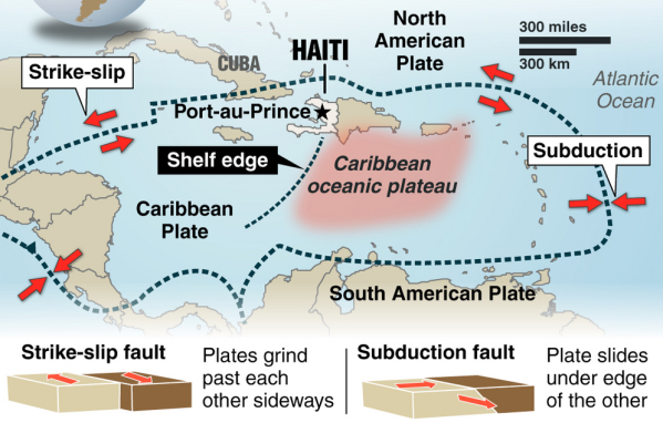
Bronquote:Seven quakes have rocked Caribbean islands as of Saturday and another tremor occurred in Haiti this Monday, raising concern among experts about a likely seismic reactivation in the area. “For some days we have observed an unusual activity that seems to be linked to the subduction of the Caribbean tectonic plate,” Saint Lucian seismologist Bruce Kleever told Prensa Latina. Seven tremors were felt in the British overseas territories in East Caribbean over the weekend, according to the Disaster Management Department of the Virgin Islands. “The seismic events were of 3.5-4.6 magnitude and could also be felt in Puerto Rico. We’re following closely the situation in the area,” said Kleever. A 4.3-magnitude quake rocked southern Haiti early morning today, one year, ten months and two days after the worst seism in the history of this country occurred. No damages or fatalities have been reported so far, but the people panicked as they relived the nightmare. According to the expert, the tremor might indicate an area of seismic activity also in the northern Caribbean plate. For years, the specialists have feared the likelihood of powerful quakes and ensuing tsunamis in the Caribbean because of the existence in the area of important focuses of danger of tectonic movement. One of them is located near Dominica, considered the point with the largest number of potentially active volcanoes in the world. However, Kleever said panic must not be triggered among the population. “Just remain on alert and take steps in case of any tremor,” he said. Steps include going to open, safer spaces, mainly in highlands, far from buildings. The Caribbean currently lacks a tsunami early warning system. Such a device would be likely available by year 2014. Watch over the area is carried out from the Hawaii-based Tsunami Warning Center, in the Pacific. At least 88 tsunamis have occurred in the Caribbean in the past 500 years, the worst of them in 1946, killing some 1,600 people.
quote:Earthquake
Country: Bolivia
State: Departamento del Beni
Location: Puerto Calvimonte
Date: 2011-11-22 : 18:48:15
Magnitude: 6.2
Depth: 533.30 km
bronquote:Earthquake
Country: Bolivia
State:
Location: El Carmen
Date: 2011-11-22 : 18:48:18
Magnitude: 6.6
Depth: 572 km
quote:Manipur experiences 23 minor tremors in a day
Imphal, November 22 2011: According to a reports of the Seismological Observatory, Manipur University, Manipur experiences at least 23 minor tremors in a day but these tremors could not be felt by the people, Director of College Development Council, Manipur University Dr RK Ranjan has disclosed.
He was speaking as Chief Guest of the inaugural function of a 5-day long NSS Mega Festival at Youth Hostel No.3, Khuman Lampak Sports Complex.
The camp is being organized under the aegis of State National Service Scheme (NSS) Cell.
Dr Ranjan informed that these minor tremors could be detected only by earthquake monitoring equipments.
Some experts opined that such repetitive minor tremors is an indication that no major quake would occurred in Manipur while others maintained that these minor tremors are only regrouping of the elements that would ultimately erupted into a devastating quake sooner or later.
In spite of contrasting views, one thing is certain that the land mass of Manipur has been formed along the fold lines that have no joining between one fold and another.
There is one large fold line running from Mao to Churachandpur and this would pose greater risk in the event of a major earthquake and this could happen at any time.
So, there is the need to step up the activities of Disaster Management in Manipur, Dr Ranjan said.

Gaat nog steeds lekker daar...
en ook:quote:BreakingNews Breaking News
Report of 6.1 magnitude earthquake off the coast of Japan - @@W7VOA, @earthquake_jp (translated) bit.ly/vMDze7
3 minutes ago Favorite Retweet Reply
quote:BreakingNews Breaking News
More: Earthquake epicenter off coast of Fukishima, Japan, felt in Tokyo; no tsunami alert posted - @HirokoTabuchi, @W7VOA
48 seconds ago Favorite Retweet Reply
I give myself very good advice
But I very seldom follow it
That explains the trouble that I'm always in
But I very seldom follow it
That explains the trouble that I'm always in
In navolging van het bericht hierboven op 16 november

Doomsday optelsom... fictie... of wordt het straks een nachtmerrie?quote:Volcanic and seismic awakening of Pan-America
The seismic and volcanic awakening of Pan-America is now well underway. The Caribbean Plate comprises an area of roughly 3.2 million square km (1.2 million square miles) and it is undergoing major stress. A series of seismic swarms in this region resulted in the outbreak of a 5.1 magnitude earthquake which struck off the coast of San Juan Puerto Rico this week. The northern boundary of the Caribbean Plate with the North American plate is a transform or strike-slip boundary which runs from the border area of Belize, Guatemala (Motagua Fault), and Honduras in Central America, eastward through the Cayman trough on south of the southeast coast of Cuba, and just north of Hispaniola, Puerto Rico, and the Virgin Islands. Part of the Puerto Rico Trench, the deepest part of the Atlantic Ocean (roughly 8,400 meters), also lies along this border. The Puerto Rico trench is at a complex transition from the subduction boundary to the south and the transform boundary to the west. The Cocos plate on the western border of Pan America is subducting under the Caribbean Plate.
The whole region is becoming more violent as geological forces increase plate pressures on the region and the sea-floor is violently stirred along the Puerto Rico trench. The trench has an unsettling history of producing very powerful earthquakes- 8.1 magnitude earthquakes struck the region both in 1787 and 1946. In light of the rising earthquake risks, UNESCO conducted a Caribbean Tsunami warning exercise on March 23, 2011 in anticipation of a 7.6 magnitude earthquake. It goes without saying, we’re overdue for another major earthquake to strike this region.
As a result of the mounting seismic tension on the western region of the plate, we’re already witnessing the volcanic and seismic awakening of much of Pan-America. On November 20, Mexico’s Popocatepetl volcano unleashed a 5 km ash cloud. On November 22nd, Guatemala’s lofty Fuego volcano followed suit with a 2 km cloud of dark ash. On November 25th, the alert status of Colombia’s Gelaras volcano was raised to orange. On November 26th, the dense upper volcanic belt of El Salvador was shaken by a swarm of over 700 tremors in a 24-hour-period. Now Ecuador’s Tungurahua volcano is the latest telltale sign that the time-bomb in the Atlanic is still ticking.
Nog maar even een optelsom...
Volgens de OP... gemiddeld 20 aardbevingen van 7.0-7.9 per jaar
Waar zitten we nu op?
Januari 4
Februari 0
Maart 1
April 2
Mei 0
Juni 1
Juli 2
Augustus 2
September 2
Oktober 2
November 0
totaal nu 16... gemiddeld genomen nog 4 te gaan in de laatste maand...
Gemiddeld komen er 2 bevingen 8.0 of hoger voor per jaar. Tot nu toe hebben we er één gehad.
December kan een zware maand wordt als moeder aarde zich aan het gemiddelde houdt...
Frutsel, de vorige keer toen je zoiets postte was het toch vrij snel raak?  . Als dat nu weer het geval is, verbied ik je nog dat soort dingen te posten

 Op
Op
quote:Ramen sneuvelen bij aardbeving NieuwZeeland
Een aardbeving met een kracht van 5,7 op de schaal van Richter in het noorden van het zuidelijke eiland van Nieuw-Zeeland heeft zaterdag ramen doen sneuvelen in de hoofdstad Wellington.
Er is geen grote schade gemeld, maar volgens een radiozender sneuvelden ramen van een kantoorgebouw in Wellington. Inwoners zagen ook spullen van kasten vallen.
Volgens seismologen lag het epicentrum van de aardbeving 40 kilometer ten westen van Wellington op 60 kilometer diepte. Het zou gaan om de zwaarste aardbeving in de regio sinds 45 jaar. (afp/mvl)
