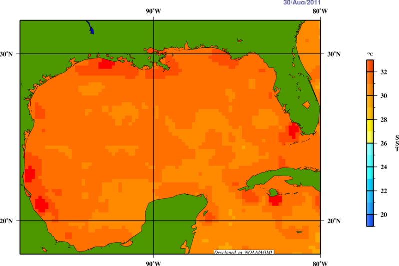
Na Irene lijkt nu de Golf van Mexico problemen te krijgen door een orkaan. Momenteel bestaat het gebied uit niet meer dan enkele grote onweersbuien en de kans is 60% dat het uitgroeit tot een tropische storm (binnen 48 uur). Maar in de Golf van Mexico, waar de watertemperatuur bijna overal boven de 30 graden is, kunnen dergelijke systemen in korte tijd enorm groeien. Het probleem met een orkaan in de Golf van Mexico is, dat de kans dat deze ergens het land op gaat zeer groot is. Waar dat gaat gebeuren is nu nog niet duidelijk.
Vooral in Texas hoopt men op veel regen. (er is daar al maanden geen druppel gevallen) En de kans is aanwezig dat ze regen gaan krijgen. De kans is ook aanwezig dat ze bezoek krijgen van een categorie 3 orkaan. Hierdoor kan de droogte veranderen in enorme wateroverlast.
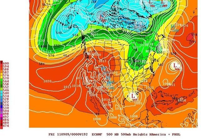
Vooral ECMWF laat in de laatste kaarten een flink syteem zien met een kerndruk van 957 mb. Een luchtdruk die zo laag is komt overeen met een Categorie 3 orkaan. (Major Hurricane).
60% kans nu dat dit gebied binnen 48 uur zich ontwikkeld tot een tropische storm

De verschillende computermodellen gaan verschillende kanten op. Van Mexico tot Florida
Hier kan al het nieuws over deze storm/orkaan verzameld worden.
Nog enkele links:
Hurricane Season 2011 # 3
Rampjaar op komst voor Amerikaanse 'natuurrampen' ?
Hittegolf en extreme droogte in de VS
quote:Next Tropical Threat in Gulf of Mexico?
We have many, many days to monitor Hurricane Katia far out in the central Atlantic Ocean. It is too early to determine if it will ever affect any land areas.
Closer to home, we have a more immediate concern. Depicted in the graphic below over the Gulf of Mexico is a tropical disturbance with shower and thunderstorm activity. Numerous computer models forecast this system developing into a tropical depression or tropical storm later this week.
It's too early to say what impacts this system may have, but residents and those with plans along the Gulf Coast late this week into the Labor Day weekend and next week should monitor the situation closely. There have already been evacuations of some personnel from offshore oil rigs.


Katrina had veel betere opbouw mogelijkheden....we wait.
Je moet ook niet alles met Katrina vergelijken natuurlijk.quote:Op donderdag 1 september 2011 13:53 schreef Drugshond het volgende:
Leuke OP... maar wat kan het worden hooguit CAT1-2.... dat zijn ze wel gewend.
Katrina had veel betere opbouw mogelijkheden....we wait.
Categorie 1-2 is al zwaar genoeg. En deze is ook nog in de Golf, dat kan voor meer neerslag zorgen dan Irene deed bij de oostkust.quote:
Leuke OP... maar wat kan het worden hooguit CAT1-2.... dat zijn ze wel gewend.
Katrina had veel betere opbouw mogelijkheden....we wait.
bron: Wundergroundquote:Gulf of Mexico disturbance a threat to develop
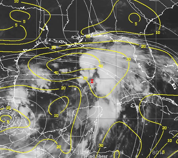
Surface winds over the Gulf of Mexico are rising today in advance of the approach of a tropical wave currently over the Western Caribbean, western tip of Cuba, and Mexico's Yucatan Peninsula. This wave is headed west-northwest at 10 - 15 mph, and is under a high 20 - 30 knots of wind shear. The wave is slowly beginning to build an increased amount of heavy thunderstorms, and this process will accelerate on Thursday when the wave enters the Gulf of Mexico. By Friday, when the wave will be near the Louisiana or Texas coast, wind shear is expected to drop to low to moderate levels, and the wave may be able to organize into a tropical depression. This process will likely take several days, and formation of a tropical depression is more likely Saturday or Sunday. NHC is giving the wave just a 10% chance of developing into a tropical depression by Friday morning. Regardless, this system will spread heavy rains to portions of the Gulf Coast by Friday, with the Upper Texas coast and the coast of Louisiana the most likely recipients of heavy rain. Strong onshore winds raising tides to 1 - 2 feet above normal are likely over Louisiana beginning on Friday, and coastal flood statements have been issued for the region. Three of our four top models for predicting tropical cyclone development forecast that a tropical depression will form this weekend or early next week, and I think it is at least 50% likely we will have Tropical Depression 13 on our hands by Monday. However, steering currents will be weak in the Gulf, and it is difficult to predict where the storm might go.The GFS model has a possible tropical depression forming by Sunday off the coast of Mississippi, then moving east-northeast over the Florida Panhandle on Monday. The ECMWF model forms the storm on Monday off the coast of Texas, and leaves the storm stalled out there through Wednesday. The UKMET model forms the storm Saturday off the coast of Louisiana, and leaves it stalled out there through Monday. If the storm did remain in the Gulf of Mexico for three days as some of the recent model runs have been predicting, it would be a threat to intensify into a hurricane.
Momenteel is de Windshear nog te hoog, maar die gaat afnemen.
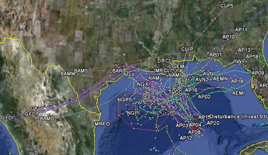
Het is niet duidelijk wat de koers zal worden. Kans bestaat dat dit systeem blijft hangen in de Golf voor een paar dagen.

quote:Tropical Depression Thirteen
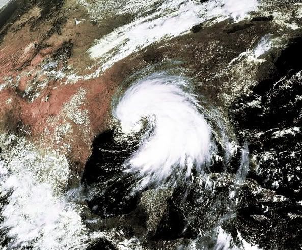
As has been predicted by the major models this week, the broad area of disturbed weather that began in the western Caribbean Sea and meandered into the Gulf of Mexico has developed into Tropical Depression Thirteen. The most recent satellite image of the depression from 11:00 p.m. CDT (Figure 1) shows deep convection mainly confined to east of center, but westerly shear of 20 knots is expected to relax over the 24 hours. While this relaxation, in combination with sea surface temperatures well above the threshold for intensification, should lead to some strengthening, the sheer size of the depression would require significant time for the system to become a hurricane.
quote:Track of Tropical Depression Thirteen
The depression's center position is still quite uncertain, as is the overall track. We should get a better idea of what is going on inside of the depression, along with pinpointing its center, after a couple of hurricane hunter aircraft complete their investigation over the next 12-24 hours.
The initial track, although uncertain, strengthens the depression into a tropical storm (which would be named Lee) on Friday while curving to the northwest. After Friday, it is possible that the system would gradually turn to the northeast, making landfall along the coast of Louisiana Sunday evening. It is important to note, however, that the track is uncertain at this time and could vary over the next few days. The depression is currently south of a high pressure ridge that is not giving much in the way of steering currents. This is also the reason for its very slow movement.
quote:Effects of Tropical Depression Thirteen
Tropical Storm Warnings have already been posted for the central Gulf Coast due to its proximity to the area. At this time, hurricane force winds are not expected for the area, but because the depression/tropical storm will be slow-moving, it may be a large precipitation-producer throughout the Southeast. You can already see rain from the northernmost part of the depression on radar out of New Orleans. Southern Louisiana through southern Alabama is set to receive 10-15 inches of rain, while higher amounts near 20 inches are possible in the hardest hit areas. This could lead to a precipitation pattern much like Hurricane Danny in 1997, except peak areas would receive less rain. Unfortunately for Texas, the major models are not currently producing any rain in the drought-stricken state, aside from areas bordering Louisiana. But, Tropical Depression Thirteen is likely to aid drought conditions in other parts of the Southeast, including Louisiana. (Figure 5).
Even ter vergelijking: In de afgelopen zomer viel de meeste neerslag in Nederland in Deelen. Over de hele zomer viel daar 445 mm.
quote:Tropische Depressie 13
Een langzaam bewegend tropische systeem met veel neerslag ploegt zich richting de Golfkust. Hier kan T13 zo'n 50 cm regen gaan achterlaten. De gouverneur van Louisiana heeft de noodtoestand uitgeroepen wegens de dreiging van overstromingen. Na Katrina in 2005 neemt men geen enkel risico meer. Er zijn waarschuwingen voor een tropische storm afgegeven van Mississippi tot Texas (incl. New Orleans). Een aantal sluizen langs de bajo's zijn gesloten. Het Corps Engineers van het USA leger -welke de structuren voor het voorkomen van overstromingen in en rond New Orleans beheert - ziet nog geen noodzaak om sluizen rond de stad te sluiten. Het is niet alleen de regenval, maar ook de combinatie met dagen van druk op de levee's en een stormvloed waardoor de dreiging groter wordt.
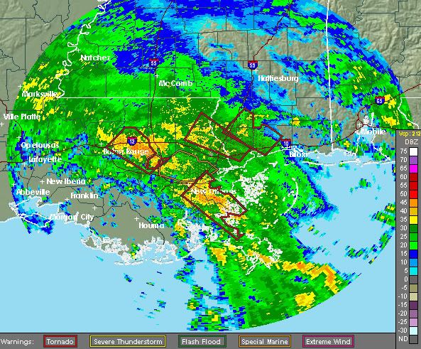
Donderdagavond viel de meeste neerslag nog steeds in de Golf van Mexico en zo'n 7-8 cm viel er in de delta van de Mississippi. Het systeem heeft zowel Shell als ExxonMobil gedwongen om de bemanning van een aantal olieplatformen te evacueren. TD 13 bevindt zich 362 km te zuidwesten van de riviermond van de Mississippi. De windsnelheden bedragen 56,3 km/h (windkracht 7) en beweegt zich noordwestwaarts met een snelheid van 3 km/h.
Louisiana heeft regen nodig, alleen niet zoveel in zo'n korte tijd. Zowel Texas als Louisiana hebben te maken met extreme droogte. Gelukkig is de stad New Orleans niet erg getroffen door de droogte en heeft al sporadisch regen gehad. Wel heeft de stad last van een natuurbrand, die de stad met een deken van rook bedekt. Hopelijk zal de regen het vuur doven. Helaas zal Texas niet zoveel meekrijgen van de neerslag van dit systeem.
onweer-online
De burgemeester van New Orleans Mitch Landrieu heeft in verband met de naderende tropische storm Lee de noodtoestand uitgeroepen. De verwachting is dat het noodweer dit weekend voor zware regenval en overstromingen gaat zorgen.
Door de noodtoestand uit te roepen kunnen de lokale autoriteiten zich sneller voorbereiden op het noodweer. Hij adviseerde inwoners van de stad passende maatregelen te treffen.
De tropische storm Lee vormde zich vrijdag ten zuiden van de kust van de staat Louisiana. Volgens de vooruitzichten kan er dit weekend tot vijftig centimeter regen vallen langs de kust van Louisiana.
nieuws.nl
De Amerikaanse olieproductie in de Golf van Mexico is gehalveerd door de tropische storm Lee. Veel olieplatforms zijn geëvacueerd en liggen daarom stil.
Lee verplaatst zich met 6 kilometer per uur langzaam in de richting de zuidkust van de VS, waar hij later dit weekend zal aankomen.
Volgens weerkundigen is er een kans van 50 tot 60 procent dat Lee uitgroeit tot een orkaan. Plaatselijk kan een halve meter regen vallen. Louisiana en Mississippi hebben de noodtoestand uitgeroepen.
Een week geleden eiste de orkaan Irene meer dan veertig levens in de VS. Bijna 900.000 huishoudens in het oosten van het land zitten nog zonder stroom.
nos
Momenteel een aantal Tornadowarnings. Hopen dat die niet teveel schade aanrichten.quote:Tropische storm Lee bereikt Amerikaanse kust
De tropische storm Lee, en de zware regenval die met de storm gepaard gaat, heeft zaterdag de kust bij de Amerikaanse staat Louisiana bereikt. Volgens de vooruitzichten kan dit weekend op sommige plaatsen tot vijftig centimeter regen vallen.
Van Mississipi tot Texas hebben autoriteiten waarschuwingen voor de tropische storm afgegeven. Waarschuwingen voor overstromingen zijn van de kust van Alabama tot aan Florida van kracht. De storm beweegt zich zeer langzaam voort, wat betekent dat het noodweer meer tijd krijgt om huis te houden in steden.
De grootste impact van Lee tot dusver is op de olieproductie in de Golf van Mexico. De helft van de dagelijkse productie is stilgelegd en een aantal boorplatformen zijn geëvacueerd.
De verwachting is dat de storm zaterdagavond aan land komt en zich vervolgens in oostelijke richting naar New Orleans begeeft. Inwoners van de stad verwachten niet dat het noodweer net zoveel schade zal aanrichten als orkanen in het verleden.
"Het is een boel regen", zei Malcolm James, een man die in 2005 tijdens orkaan Katrina zijn huis verloor. "Het is helemaal niets vergeleken bij Katrina. Dit is mild, het had veel erger kunnen zijn."
nieuws.nl
Ik vraag me af wat Katia gaat doen inderdaad. Het is nog niet helemaal duidelijk.quote:
Katia was gisteren afgezwakt tot een Tropical Storm, maar zal wel weer later aan kracht winnen.
[ afbeelding ]
Dit topic gaat over Lee.
Katia is te vinden in dit topic: Hurricane Season 2011 # 3
[ Bericht 0% gewijzigd door #ANONIEM op 03-09-2011 17:10:50 ]
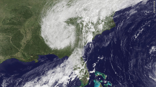
Jan Visserquote:Ondertussen teistert de actieve tropische storm Lee op dit moment de Amerikaanse Golfkust. De depressie met een kerndruk van 988 hPa ging zondagochtend om 5 uur Nederlandse tijd vergezeld van een gemiddelde maximale windsnelheid van 85 km/u. Door de zeer lage treksnelheid van slechts 4 km/u zorgt Lee gedurende het weekeinde in de staten Louisiana, Mississippi en Alabama alsmede in de Tennessee Valley voor een zondvloedscenario.
De Amerikaanse weerdienst NWS verwacht op uitgebreide schaal (ook in het geplaagde New Orleans) neerslagsommen van 250 tot 380 liter per vierkante meter met pieken tot 500 liter. Florida dient rekening te houden met 100 ŕ 200 mm aan regen. In Pascagoula, Mississippi, kwam gisteren al 7,54 inches (190 mm) in de regenmeter terecht.
quote:SAUCIER, Miss. — While Lee's winds had lost some of their punch by early Monday, forecasters warned that its slow-moving rain clouds posed a worse flooding threat to inland areas with hills or mountains in the coming days.
Flash flood watches and warnings were in effect across a swath of the Southeast early Monday, stretching from the lower Mississippi Valley, eastward to the Florida Panhandle and the southern Appalachians, according to the Hydrometeorological Predication Center.
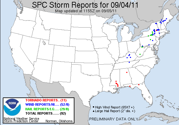
The massive storm system dumped more than a foot of rain in New Orleans and spawned tornadoes elsewhere before it weakened to a tropical depression Sunday night. Its remnants were expected to continue to march to the northeast.
Heavy rain will hit parts of Mississippi to the central Appalachians on Monday, with bands of thunderstorms and heavy rain expected to persist from southeastern Louisiana to the Florida Panhandle, The Weather Channel reported.
Closer to the Gulf, the water is "just going to sit there a couple of days," National Hurricane Center specialist Robbie Berg said. "Up in the Appalachians you get more threat of flash floods."
The threat of tornadoes spawned by Lee's remnants was diminishing early Monday, said Fred Zeigler, a meteorologist with the National Weather Service. But he said coastal flooding would remain a concern.
quote:A longtime Texas sheriff says it was the fastest-moving fire he has ever seen. Six homes were toppled within minutes, including one trailer where a woman and her 18-month-old daughter were killed because they couldn't escape in time.
Authorities said the fires, including the one that killed the two people Sunday near the East Texas community of Gladewater, were propelled partly by the high winds caused by Tropical Storm Lee. Neighborhoods across eastern and central parts of the state were reporting widespread damage covering thousands of acres.


quote:Remnants of Lee is aiding in slow-moving, training rain and thunderstorms across portions of central and east-central Pennsylvania and New York on Wednesday, September 7 giving way to major flooding.
More pictures from PA

quote:Thousands evacuated
Thousands of people were told to evacuate their homes Thursday as the remnants of former Tropical Storm Lee moved across already-sodden portions of the Northeast, triggering near-historic flooding and leaving at least three people dead.
Central Pennsylvania was hard-hit. In Wilkes-Barre, some 65,000 people were told to leave their homes in the Wyoming Valley by 8 p.m. Thursday as the Susquehanna River rose past flood stage, according to CNN affiliate WBRE.
As of 4 a.m. Thursday, the Susquehanna River was at 26 feet and rising fast near Wilkes-Barre. Flood stage for low-lying areas is 22 feet, the station reported. The valley has a levee system, but the river is projected to crest near 39.6 feet Friday -- within 18 inches of the top of the levees.
A 71-year-old man died Wednesday night in Derry Township, Pennsylvania, as he was bailing water out of the basement of his home and the walls of the structure caved in, said Chief Patrick O'Rourke of Derry Township Police.
A second person drowned early Thursday near Brickerville in Lancaster County, CNN affiliate WGAL reported.
A third person died about 4:30 a.m. Thursday in North Lebanon Township, Pennsylvania, police said. A motorist became stranded in high water, and was outside their vehicle when they were struck by another vehicle, which then left the scene. The suspect and vehicle were located, authorities said.
About 75 milesaway, Little Fishing Creek overflowed its banks and flooded several homes and businesses in the Millville area.
"It came quick," resident Corey Sweeney told WBRE. "I knew it was going to flood, but I didn't expect it to come up this far. I looked at it this morning and it was rising about 6-7 inches every 20 minutes."
Many recalled the flooding caused by Hurricane Agnes in 1972. That storm dumped as much as 18 inches of rain on the area in two days, destroying more than 68,000 homes and 3,000 businesses and leaving 220,000 Pennsylvanians homeless.
klinkt ernstig daarroquote:Mandatory evacuation (ordered to leave by 4pm ET) of over 100,000 residents along Susquehanna River in NE PA, inundated by Agnes ('72).
quote:Flooding leads to evacuations of 100K in Pa.
WILKES-BARRE, Pa. (AP) -- Officials in northeastern Pennsylvania called for a mandatory evacuation of more than 100,000 residents living along the Susquehanna River on Thursday due to expected flooding. The area was inundated in the historic Agnes flood of 1972.
Luzerne County Management Agency official Frank Lasiewicki told The Associated Press Thursday the river is projected to crest at 41 feet between 4 p.m. and 8 p.m. Thursday - the same height as the levee system protecting riverfront communities including Wilkes-Barre and Kingston.
Residents were ordered to leave by 4 p.m.
Wilkes-Barre Mayor Tom Leighton said residents should prepare for an extended evacuation of 72 hours and advised them to take clothing, food and prescription medicine. He also asked city businesses to close their doors by noon.
The evacuations come as the remnants of Tropical Storm Lee dumped heavy rain and caused havoc around the Northeast on Thursday, bringing floods that cut off major highways and caused some schools to open late or not at all.
Flood watches and warnings were in effect from Maryland to New England

The extreme rains are due the the remains of Tropical Storm Lee interacting with a stationary front draped along the Eastern U.S. Adding to the potent moisture mix last night was a stream of tropical moisture associated with Hurricane Katia that collided with the stationary front. You don't often see a major city break its all-time 24-hour precipitation record by a 60% margin, according to wunderground's weather historian, Christopher C. Burt, and he can't recall ever seeing it happen before. It's worth noting that the Susquehanna River Binghamton stream gage, which has been in operation since 1847, is due to be shut off in 3 weeks due to budget cuts. Here's the note at the USGS web site:
Wunderground
WASHINGTON - Na de zware overstromingen van de afgelopen dagen heeft de Amerikaanse president Barack Obama donderdagavond laat (plaatselijke tijd) de noodtoestand voor de staat New York uitgeroepen.
Dat heeft het Witte Huis in een verklaring laten weten.
Door het uitroepen van de noodtoestand kunnen federale agentschappen acties coördineren om levens te redden en om bezittingen te beschermen, aldus het Witte Huis.
De overstromingen hebben al zeker vijf levens geëist in het oosten van de VS.
nu.nl