WKN Weer, Klimaat en Natuurrampen
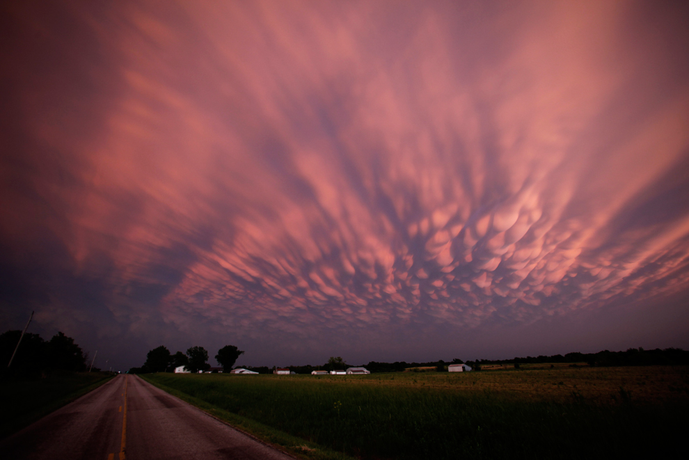
Lees alles over het onstuimige weer op onze planeet, volg orkanen en tornado's, zie hoe vulkanen uitbarsten en hoe Moeder Aarde beeft bij een aardbeving. Alles over de verwoestende kracht van onze planeet en tal van andere natuurverschijnselen.


Alsof het weekend is, zoveel zijn er nu online ja.quote:Op donderdag 19 mei 2011 22:47 schreef Ceetje.. het volgende:
de chasers twitteren er op los momenteel
[ afbeelding ]

hebben allemaal wat eerder weekend genomen denk ik. Zou die file daar wel eens live willen zien. Er schijnt trouwens ook een Nederlands chase team te zijn nu, streamen alleen nietquote:Op donderdag 19 mei 2011 22:49 schreef Drassss het volgende:
[..]
Alsof het weekend is, zoveel zijn er nu online ja.
Altijd de sarcasme modus aan
Moet er morgen toch weer vroeg uit dus ik ga je niet zo lang meer verzegelenquote:
ik heb het in de gaten, ach, wacht nog wel een tijdje af
Edit: Tornado warning voor de cell NO van Altus Oklahoma.
Vandaag reist er ook een Nederlander af naar Tornado Alley, hij gaat daar chasen met Cloud9 tours. Mocht hij tijd hebben dan schrijft hij op zijn blog updates. Mensen die interesse hebben kunnen het lezen op zijn site:
http://www.supercell.nl/blogs/index.php?blog=5
http://www.supercell.nl/blogs/index.php?blog=5
Weer of geen weer, altijd actueel www.onweer-online.nl
van wat ik begrepen heb welquote:
Komende dagen weer zwaar weer op komst dus?
Altijd de sarcasme modus aan
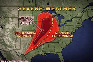
accuweatherquote:"The corridor from Tulsa, Okla., to St. Louis, Mo., to Madison, Wis., stands to be at the greatest risk for tornadic activity into this evening."
Violent thunderstorms, some producing tornadoes, will target cities from the southern Plains through the Great Lakes later this afternoon and this evening ahead of a large storm system.
Thunderstorms this morning are ongoing from central Arkansas through northern Mississippi and western Tennessee, producing flooding downpours and large hail.
An even larger event is on the horizon beginning late this afternoon farther to the west of the current storms.
Sunshine will prevail during the morning and midday hours from Dallas, Texas, through Springfield, Mo., and Chicago, Ill. This sunshine will help to heat up the atmosphere, thereby causing the air to rise.
As a cold front approaches from the west, it will tap into the warm, moist air across the eastern Plains and the Mississippi River Valley, leading to the development of violent thunderstorms by the afternoon hours.
Large hail to the size of baseballs and damaging wind gusts will be the main threats from the strongest thunderstorms. Torrential downpours could trigger flash flooding problems as well.
Tornadoes will also be a problem, especially across the central and northern Mississippi River Valley. The wind shear or "twisting of the winds in the atmosphere" is greater across this region, therefore creating a greater threat for tornadoes.
The corridor from Tulsa, Okla., to St. Louis, Mo., to Madison, Wis., stands to be at the greatest risk for tornadic activity this afternoon and evening.
You better lose yourself in the music
The moment, you own it, you better never let it go
The moment, you own it, you better never let it go
Flinke schade weer in Missouri 
"We meet every day at the same cafe, six-thirty and no one knows she'll be there."
Nou, terwijl wij allemaal sliepen is het toch behoorlijk los gegaan als ik al die berichten zo lees 
http://edition.cnn.com/20(...)er/index.html?hpt=T2
http://www.nu.nl/buitenla(...)n-tornado-in-vs.html
http://edition.cnn.com/20(...)er/index.html?hpt=T2
http://www.nu.nl/buitenla(...)n-tornado-in-vs.html
Opgeblazen gevoel of winderigheid? Zo opgelost met Rennie!

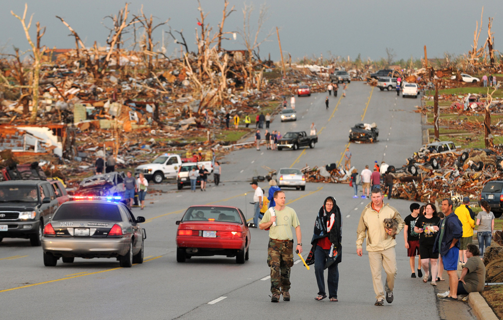
Tientallen doden door tornado in de VS
WASHINGTON - Door een zware wervelstorm in het Middenwesten van de Verenigde Staten zijn zondag zeker dertig doden gevallen. Dit is maandag (onze tijd) vernomen van een plaatselijke lijkschouwer.
De doden vielen in de stad Joplin in de staat Missouri. Naast de doden is een onbekend aantal gewonden gevallen.
Woonhuizen, kerken en een ziekenhuis raakten beschadigd, zo meldden plaatselijke media. Mensen raakten bekneld onder het puin van hun huizen of in vernielde auto's.
Amerikaanse meteorologen bevestigden dat de wervelstorm door het centrum van de stad van zo'n 50.000 inwoners is getrokken.
Enkele weken geleden zijn in de VS 354 doden gevallen door wervelstormen.
nu.nl

Daar is weinig van over, Joplin.. het is/was een bekend plaatsje aan de oude route 66.
And what rough beast, its hour come round at last,
Slouches towards Bethlehem to be born?
Slouches towards Bethlehem to be born?

WTF, wat een schade in Joplin zeg.. Lijkt op (opnieuw) een EF5..
's Avonds een man, overdags rustig an

360 graden foto van de stad na de tornado, zo te zien in de buurt van het ziekenhuis.
And what rough beast, its hour come round at last,
Slouches towards Bethlehem to be born?
Slouches towards Bethlehem to be born?
Op dit moment weer een heftige bui onderweg naar Joplin... hopelijk gaat ie er langs
* I intend to live forever, so far so good! *
Lijkt er recht op af te gaan. Er is nog geen tornado warning.quote:
Op dit moment weer een heftige bui onderweg naar Joplin... hopelijk gaat ie er langs
Holy shit.quote:
First Person video of Joplin MO tornado 5/22/11


Severe Weather voor vandaag is nu verhoogd naar moderate risk.
quote:More Severe Weather Expected Today
The area will have little time to clean up as another round of severe weather is expected again today.
A complex of severe thunderstorms tracked across Joplin and southwestern Missouri this morning producing gusty winds and hail.
Hail, 1 inch in diameter, was reported in the vicinity of Joplin Municipal Airport along with wind gusts to 36 mph.
Additional thunderstorms will develop this afternoon across the southern Plains, potentially affecting the Joplin area again.
Torrential downpours and frequent lightning associated with these thunderstorms will interfere with cleanup efforts. Localized flash flooding is likely as the ground is already saturated due to above-normal rainfall the last two months.
High winds could cause additional damage and may topple cranes which are in the city helping with the cleanup.
rest van verhaal
Accuweatherquote:Another Round of Southern Plains Severe Weather Tuesday
"The greatest threat of tornadic activity Tuesday lies from Oklahoma City... to already hard-hit Joplin, Mo."
After severe thunderstorms and tornadoes damaged parts of the southern Plains over the weekend, another round of devastating weather is on the way for Tuesday.
The same frontal boundary which is sparking severe storms from Texas to Pennsylvania today will sink ever so slightly southward by Tuesday. South of this boundary, a very warm and moist air mass remains in place, setting the stage for additional rounds of severe weather from Texas through the mid-Atlantic.
Along the end of the front, a strong low pressure system will strengthen across the southern Plains Tuesday, creating ideal conditions for dangerous storms and potential tornadoes.
The greatest threat of tornadic activity on Tuesday lies in the corridor from Oklahoma City, Okla., to Wichita, Kan., to already hard-hit Joplin, Mo.
These locations will see an elevated threat of tornadoes, hail to the size of baseballs and flash flooding from thunderstorms that develop.
Just as is happening today, the severe weather threat will also be present farther east through the Ohio Valley into the mid-Atlantic states.
Residents from Paducah, Ky., through Charleston, W.Va., to Washington, D.C., will have to be on the lookout for rapidly changing weather conditions on Tuesday.
Over the mid-Atlantic and Ohio Valley, the greatest threats will be large hail and damaging wind gusts. However, an isolated tornado or two cannot be ruled out that far east.
As with most severe weather, the greatest coverage of thunderstorms will occur during the afternoon and evening hours as the daytime heating causes the air to rise rapidly.
Anyone in these areas should expect travel delays, especially during the afternoon and evening hours. Be prepared for any detours or delays around any damage that may occur.
Check back with AccuWeather.com throughout the next few days for the latest on the ongoing severe weather. Residents are encouraged to listen to local media outlets and heed all severe weather warnings issued.


"Torandoes" !!!!!!!quote:
Severe Weather voor vandaag is nu verhoogd naar moderate risk.
[..]
[..]
Accuweather
Deadliest U.S. tornado since 1953 rips through Joplin, Missouri, killing 89
The incredibly violent tornado season of 2011 struck another sickening blow last night, when a violent tornado carved a ½ – ¾ mile-wide path of devastation through Joplin, Missouri. At least 89 people died, hundreds were injured, and huge sections of the town virtually obliterated. Damage from the tornado is so severe that pavement was ripped from the ground, which is characteristic of a top-end EF-5 tornado with winds in excess of 200 mph. This was almost certainly a least an EF-4 tornado with winds over 166 mph, and the level of damage is so extreme that this is likely to surpass last month's Tuscaloosa-Birmingham tornado as the costliest tornado of all-time.
Figure 1. Cars stacked on top of each other in front of the heavily damaged St. Johns Regional Medical Center after the May 22, 2011 tornado in Joplin, Missouri. Note the pavement ripped up from the road and piled in front of the cars. Tornadoes powerful enough to rip up pavement are frequently classified as EF-5 with winds in excess of 200 mph. Image credit: Chris McCrillis, posted to Twitter.
The huge supercell thunderstorm that spawned the Joplin tornado formed over extreme southeast Kansas yesterday afternoon, along the boundary between warm, moist air flowing northwards from the Gulf of Mexico, and cold, dry air moving south from Canada. NOAA's Storm Prediction Center (SPC) had put the region in its “moderate risk” region for severe weather. As the supercell moved into Southwest Missouri, it spawned the tornado that roared through Joplin at 5:45pm CDT. This storm generated other tornadoes, straight-line wind damage, and flash flooding from torrential rains that exceeded six inches as it moved east southeast across Southwest Missouri. SPC recorded 48 preliminary reports of tornadoes yesterday, bringing the 2-day total for the current outbreak to 70. A tornado also killed one person and injured 22 in Minneapolis Sunday. Separate tornadoes killed one person each in Andice, Texas and Reading, Kansas on Saturday—the first tornado deaths in the U.S. since the April 25 – 28 Super Outbreak.
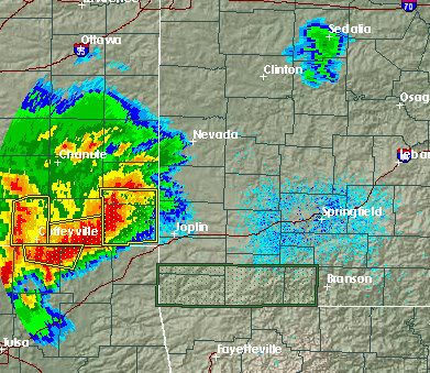
Figure 2. Radar reflectivity image of the supercell thunderstorm that spawned the Joplin, Missouri tornado, ½ hour after it devastated the city (circle with the “+” symbol.)
Figure 3. Radar Doppler velocity image of the supercell thunderstorm that spawned the Joplin, Missouri tornado, ½ hour after it devastated the city (circle with the “+” symbol.)
Figure 4. Satellite image taken at 5:45pm CDT May 22, 2011, when the Joplin, Missouri tornado was occurring. Image credit: NASA/GSFC.
Deadliest tornado since 1953
Yesterday's Joplin, Missouri tornado is the deadliest single tornado in the U.S. since June 10, 1953, when 94 people died in the Worcester, Massachusetts tornado. The previous deadliest tornado in the past 50 years occurred just last month, when 65 people died in the Tuscaloosa-Birmingham EF-4 tornado in Alabama. This year's tornado death toll now stands at 455, making it the deadliest year for tornadoes in the U.S. since 1953, when 519 people died. The deadliest year was 1925, with 794 deaths. That was the year of the deadliest U.S. tornado of all-time, the great Tri-State tornado, which killed 695 people in Missouri, Illinois, and Indiana.
Wunderground
The incredibly violent tornado season of 2011 struck another sickening blow last night, when a violent tornado carved a ½ – ¾ mile-wide path of devastation through Joplin, Missouri. At least 89 people died, hundreds were injured, and huge sections of the town virtually obliterated. Damage from the tornado is so severe that pavement was ripped from the ground, which is characteristic of a top-end EF-5 tornado with winds in excess of 200 mph. This was almost certainly a least an EF-4 tornado with winds over 166 mph, and the level of damage is so extreme that this is likely to surpass last month's Tuscaloosa-Birmingham tornado as the costliest tornado of all-time.
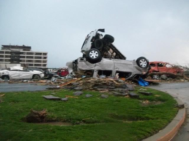
Figure 1. Cars stacked on top of each other in front of the heavily damaged St. Johns Regional Medical Center after the May 22, 2011 tornado in Joplin, Missouri. Note the pavement ripped up from the road and piled in front of the cars. Tornadoes powerful enough to rip up pavement are frequently classified as EF-5 with winds in excess of 200 mph. Image credit: Chris McCrillis, posted to Twitter.
The huge supercell thunderstorm that spawned the Joplin tornado formed over extreme southeast Kansas yesterday afternoon, along the boundary between warm, moist air flowing northwards from the Gulf of Mexico, and cold, dry air moving south from Canada. NOAA's Storm Prediction Center (SPC) had put the region in its “moderate risk” region for severe weather. As the supercell moved into Southwest Missouri, it spawned the tornado that roared through Joplin at 5:45pm CDT. This storm generated other tornadoes, straight-line wind damage, and flash flooding from torrential rains that exceeded six inches as it moved east southeast across Southwest Missouri. SPC recorded 48 preliminary reports of tornadoes yesterday, bringing the 2-day total for the current outbreak to 70. A tornado also killed one person and injured 22 in Minneapolis Sunday. Separate tornadoes killed one person each in Andice, Texas and Reading, Kansas on Saturday—the first tornado deaths in the U.S. since the April 25 – 28 Super Outbreak.
Figure 2. Radar reflectivity image of the supercell thunderstorm that spawned the Joplin, Missouri tornado, ½ hour after it devastated the city (circle with the “+” symbol.)
Figure 3. Radar Doppler velocity image of the supercell thunderstorm that spawned the Joplin, Missouri tornado, ½ hour after it devastated the city (circle with the “+” symbol.)
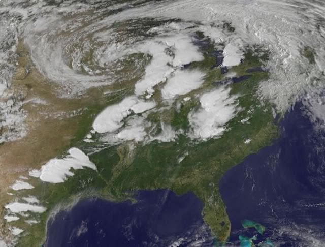
Figure 4. Satellite image taken at 5:45pm CDT May 22, 2011, when the Joplin, Missouri tornado was occurring. Image credit: NASA/GSFC.
Deadliest tornado since 1953
Yesterday's Joplin, Missouri tornado is the deadliest single tornado in the U.S. since June 10, 1953, when 94 people died in the Worcester, Massachusetts tornado. The previous deadliest tornado in the past 50 years occurred just last month, when 65 people died in the Tuscaloosa-Birmingham EF-4 tornado in Alabama. This year's tornado death toll now stands at 455, making it the deadliest year for tornadoes in the U.S. since 1953, when 519 people died. The deadliest year was 1925, with 794 deaths. That was the year of the deadliest U.S. tornado of all-time, the great Tri-State tornado, which killed 695 people in Missouri, Illinois, and Indiana.
Wunderground
 Op
Op
holy shit, wat erg weer ditquote:
 Op
Op
Altijd de sarcasme modus aan
pfff, ik ben even stil na het zien van deze beelden.
You better lose yourself in the music
The moment, you own it, you better never let it go
The moment, you own it, you better never let it go
inmiddels weer een moderate risk, met als ik 't goed zie in oklahoma een 10% tornado risk, volgens de stormtracker op news9
Altijd de sarcasme modus aan
hallo,
ik probeer de streams ook een beetje te volgen, maar heb er nog niet één gevonden met geluid.
Hoe kom ik aan geluid, zodat ik een beetje kan volgen of ze een storm zien aankomen
ik probeer de streams ook een beetje te volgen, maar heb er nog niet één gevonden met geluid.
Hoe kom ik aan geluid, zodat ik een beetje kan volgen of ze een storm zien aankomen
“Loop niet voor me, want ik volg niet.
Loop niet achter me, want ik leid niet.
Loop gewoon naast me en wees mijn vriend.”
Loop niet achter me, want ik leid niet.
Loop gewoon naast me en wees mijn vriend.”
Hallo Kaatje, Brett Adair heeft geluid en zit ook in het gebied van Oklahoma City, Tulsa en Kansas City dat we vandaag in de gaten kunnen houdenquote:
hallo,
ik probeer de streams ook een beetje te volgen, maar heb er nog niet één gevonden met geluid.
Hoe kom ik aan geluid, zodat ik een beetje kan volgen of ze een storm zien aankomen
You better lose yourself in the music
The moment, you own it, you better never let it go
The moment, you own it, you better never let it go
ze hebben niet allemaal geluid kaatje, je moet de kaart ook een beetje in de gaten houden, en je kunt ook vaak aan het aantal kijkers op een stream zien waar "aktie" is.quote:
hallo,
ik probeer de streams ook een beetje te volgen, maar heb er nog niet één gevonden met geluid.
Hoe kom ik aan geluid, zodat ik een beetje kan volgen of ze een storm zien aankomen
Altijd de sarcasme modus aan
Ik heb het gemist, wat zei hij/zij?quote:
Pfff die Nederlander die daar woont net op Nederland 3
Dit is nog erger lijkt me?quote:
Het doet me altijd weer denken aan Greensburg.
's Avonds een man, overdags rustig an
Greensburg was inderdaad een klein stadje wat compleet werd verwoest. Zie de foto in de OP.
Het is een wonder dat daar toen niet meer slachtoffers bij zijn gevallen. Het lijkt wel alsof de kleinere dorpjes beter zijn voorbereid op een tornado dan een grotere stad.
[ Bericht 0% gewijzigd door #ANONIEM op 23-05-2011 23:09:41 ]
Het is een wonder dat daar toen niet meer slachtoffers bij zijn gevallen. Het lijkt wel alsof de kleinere dorpjes beter zijn voorbereid op een tornado dan een grotere stad.
[ Bericht 0% gewijzigd door #ANONIEM op 23-05-2011 23:09:41 ]
Brandon Sullivan rapporteerde een mogelijke touchdown net buiten Okeene, OK.
Tornado watch in effect voor het westen van Oklahoma ten NW van Oklahoma City en
http://www.kfor.com/news/livestreaming/
is streaming live
Update 00:00
Supercel obsorbeerd de storm vanuit het zuiden, Tornedowarning is ingetrokken.
[ Bericht 5% gewijzigd door MaryMouse op 24-05-2011 00:03:29 ]
Tornado watch in effect voor het westen van Oklahoma ten NW van Oklahoma City en
http://www.kfor.com/news/livestreaming/
is streaming live
Update 00:00
Supercel obsorbeerd de storm vanuit het zuiden, Tornedowarning is ingetrokken.
[ Bericht 5% gewijzigd door MaryMouse op 24-05-2011 00:03:29 ]
You better lose yourself in the music
The moment, you own it, you better never let it go
The moment, you own it, you better never let it go
Zo te zien zijn er duizenden huizen verwoest, dus lijkt me wel.quote:
And what rough beast, its hour come round at last,
Slouches towards Bethlehem to be born?
Slouches towards Bethlehem to be born?
Vandaag/Vannacht weer een high risk... die mensen is geen rust gegund daar.

* I intend to live forever, so far so good! *
Uh oh.quote:
Vandaag/Vannacht weer een high risk... die mensen is geen rust gegund daar.
[ afbeelding ]
En meer, te vinden uiteraard op de Big Bostin Picture site:
http://www.boston.com/big(...)os_strike_again.html
Opgeblazen gevoel of winderigheid? Zo opgelost met Rennie!
Accuweather verwacht vandaag 50 tornado's of meer
quote:Two Days Of Destructive Tornadoes
"AccuWeather.com Meteorologists are forecasting a significant tornado outbreak which could include 50 or more tornado reports..."
The tornado threat will increase across the Plains today as another round of potentially deadly storms take shape.
AccuWeather.com Meteorologists are forecasting a significant tornado outbreak today which could include 50 or more tornado reports, most of which could occur across eastern Oklahoma and eastern Kansas.
The greatest threat of tornadic activity lies in the corridor from Oklahoma City, Okla., to Wichita, Kan., to already hard-hit Joplin, Mo.
This also includes the cities of Dallas, Texas, Topeka, Kan., and Tulsa, Okla.
Any tornadoes that develop will have the to potential to be long-lived and long tracked, even more so than the tornado that destroyed Joplin.
Thunderstorms will first erupt during the afternoon hours across central Kansas, central Oklahoma and north-central Texas. These thunderstorms will quickly turn severe, producing potentially devastating tornadoes.
Although these storms will occur during the day, tornadoes may still be difficult to see. As was the case with the Joplin tornado, any of these twisters that become wrapped up with rain will be tough to distinguish.
Besides tornadoes, these storms will also bring large and damaging hail and torrential downpours which could lead to flash flooding.
Travel could also be restricted due to debris on Interstates 70, 40, 44 and 35.
These storms will then track eastward late on Tuesday afternoon into Tuesday night bringing the threat for destructive tornadoes into the middle-Mississippi River Valley for the nighttime hours.
Residents should be advised that tornadoes that occur at night are the most dangerous due to the simple fact that most people are asleep. Persons are urged to keep tuned to local media outlets during this severe weather outbreak and have a plan of action prepared should severe weather strike.
This region has been hit hard over the last several days. On Sunday, a deadly EF-4 tornado struck Joplin, Mo., while numerous areas had hail and damaging winds on Monday.

quote:Tornado in VS dodelijkste sinds 1950
(Novum/AP) - JOPLIN - Een van de tornado's die deze week door de Amerikaanse staat Missouri raasde, heeft aan 117 mensen het leven gekost. Daarmee is het de dodelijkste tornado in de Verenigde Staten sinds 1950.
Volgens de Amerikaanse meteorologische dienst stamde het vorige record uit 1953, toen 116 mensen omkwamen bij een tornado in Flint, in de staat Michigan.
Vorige maand kwamen bij een reeks tornado's in het zuiden van de Verenigde Staten meer dan 350 mensen om het leven.
Dit jaar al 482 doden door tornado's.
En het seizoen is nog niet voorbij...
En het seizoen is nog niet voorbij...
quote:This year's tornado death toll now stands at 482, making it the deadliest year for tornadoes in the U.S. since 1953, when 519 people died. That year, three heavily populated cities received direct hits by violent tornadoes. Waco, Texas (114 killed), Flint, Michigan (115 killed), and Worcester, Massachusetts (89 – 94 killed) all were hit by violent F-4 or F-5 tornadoes. A similar bad tornado year occurred in 1936, when violent tornadoes hit Tupelo Mississippi (216 killed), and Gainesville, Georgia (203 killed.)
zowiezo elk stadje/dorpje. Tornado's zijn mooi om te zien, maar de verwoesting die ze teweeg brengen zie ik maar liever niet eerlijk gezegdquote:
Outbreak kansen voor vanavond en vannacht zijn weer hoog
Laten we hopen dat Joplin gespaard blijft
Altijd de sarcasme modus aan
Tulsa NWS spreekt van
Veel erger dan 27 april kan het toch nietquote:After reviewing the latest data & computer models, it’s very likely we’ll be seeing a historic event unfold today.
Volgens Accuweather wel.quote:
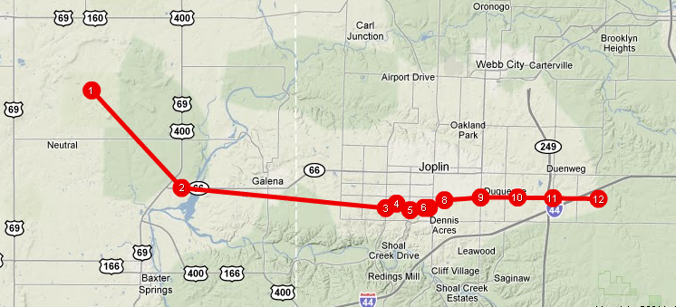
Hier een animated timeline met fotos van het pad dat de Joplin tornado heeft genomen.
You better lose yourself in the music
The moment, you own it, you better never let it go
The moment, you own it, you better never let it go
quote:
Wunderblogquote:A violent high-end EF-4 tornado with winds of 190 – 198 mph carved a 7-mile long, ¾ to one mile-wide path of near-total destruction through Joplin beginning at 5:41pm CDT Sunday evening. In nine terrifying minutes, the tornado killed at least 116 people, injured 500 more, and obliterated huge sections of the town. Damage from the tornado is so severe that pavement was ripped from the ground, and the level of damage is so extreme that this is likely to surpass last month's Tuscaloosa-Birmingham tornado as the costliest tornado of all-time.
Oh man, dat kan er ook nog wel bij. En ja, Joplin was (volgens de eerste berekeningen) een EF4.quote:
Tulsa NWS spreekt van
[..]
Veel erger dan 27 april kan het toch niet

nog niet kunnen ontdekken, heb de nieuwszenders geprobeerd voor oklahoma en texas die in de OP staanquote:
Is er al ergens een live-streams van een nieuwszender daar in de regio?
Altijd de sarcasme modus aan