WKN Weer, Klimaat en Natuurrampen
Lees alles over het onstuimige weer op onze planeet, volg orkanen en tornado's, zie hoe vulkanen uitbarsten en hoe Moeder Aarde beeft bij een aardbeving. Alles over de verwoestende kracht van onze planeet en tal van andere natuurverschijnselen.


Dat moet echt ongelofelijk groot zijn.quote:Op de Zuidpool is een enorm ijsblok, ongeveer zo groot als Luxemburg, losgeraakt. Het kan op termijn veranderingen in de stromingen in de oceanen veroorzaken. Dat kan ook op het noordelijk halfrond voor minder milde winters zorgen.
Dat hebben Australische en Franse wetenschappers laten weten.
Op 12 en 13 februari is een brok van 2550 vierkante kilometer groot afgebroken van de enorme ijsmassa die Mertz Tongue Glacier wordt genoemd.
De breuk is veroorzaakt door een andere ijsberg, die tegen de ijsmassa aan klapte. De losgeraakte kolos bevat voldoende water om een jaar lang in de behoefte aan drinkwater van de hele mensheid te voorzien.
Neal Young, een Australische onderzoeker van de Mertz Tongue Glacier zei dat er geen bewijs is dat veranderingen in het klimaat iets met deze breuk te maken hebben. Dit gebeurt gewoon eens in de vijftig tot honderd jaar, zei Young.
Iemand foto's?
Life is Music


Das bizar groot 

vraag me af of het om hetzelfde stuk ijs gaat als hier
IJsschots zo groot als Luxemburg afgebroken
toen spraken ze van een stuk zo groot als Luxemburg wat bezig was af te breken
is dat dan nu echt gebeurd?
vraag me af of het om hetzelfde stuk ijs gaat als hier
IJsschots zo groot als Luxemburg afgebroken
toen spraken ze van een stuk zo groot als Luxemburg wat bezig was af te breken
is dat dan nu echt gebeurd?
Dit onzinnieuws, dames en heren is nou een mooi staaltje mediaspin (vroeger ook wel propaganda genoemd). Nieuwstechnisch hebben we het dan over opgewarmd nieuws, zeer waarschijnlijk afkomstig van milieu- en natuurorganisaties die een 'angle' zoeken om 'cry wolf' te doen op die milieutop in Kopenhagen. En als zo'n nieuwtje eenmaal de persbureaus binnen is, is er geen houden aan. Vorige maand was het nog een ijsschots, nu is het opeens een superijsberg. Wat hier gebeurt is een soort van urgentie creëren terwijl een drijvende ijsschots één van de langzaamste dingen op aarde is. In werkelijkheid is die ijsschots B17B al minimaal NEGEN JAAR op drift met de gigantische snelheid van tussen de 0 en 1,8 km/u
Vergeef mij de spelfouten, maar ik fok op een mobieltje

http://www.aad.gov.au/default.asp?casid=37551
hier staan satelietfoto's... geen idee waarom ze hier niet werken
hier staan satelietfoto's... geen idee waarom ze hier niet werken
Waar de stroming m heen voert. En als je het kaartje op wikipedia mag geloven, dan zijn er niet zo veel stromingen die vanuit Antarctica naar het zuiden voeren, zie hier: http://nl.wikipedia.org/wiki/Zeestroomquote:
De meeste ijsbergen op antarctica dobberen dus een beetje rondjes om het continent, tot ze door de golven en temperaturen boven 0 uit elkaar gevallen zijn.
Ijsbergen vanaf de Noordpool daarentegen, dobberen wel aan de westkant van groenland naar beneden, en komen rgelmatig tot op de breedtegraad van New york. En daar is veel scheepvaartverkeer, niet zo handig dus...
Mijn foto's op Flickr!
[b]Op 15-09-2006 10:28 schreef Hans_Gielus[/b]
Namens Fryslân hoop ik dat je van een berg afkukelt _O-
[b]Op 15-09-2006 10:28 schreef Hans_Gielus[/b]
Namens Fryslân hoop ik dat je van een berg afkukelt _O-
geweldige foto's, en dat gaat met zoveel geweld!quote:Op vrijdag 26 februari 2010 15:10 schreef Frutsel het volgende:
http://www.aad.gov.au/default.asp?casid=37551
hier staan satelietfoto's... geen idee waarom ze hier niet werken
Maar, er zijn dus mensen die zich druk maken om een gletschertong (die allang in zee drijft, maar alleen nog vast zit aan de rest van de gletscher) , die los getikt wordt door een nog veel grotere ijsberg, die toch al ronddreef?
OK.
Mijn foto's op Flickr!
[b]Op 15-09-2006 10:28 schreef Hans_Gielus[/b]
Namens Fryslân hoop ik dat je van een berg afkukelt _O-
[b]Op 15-09-2006 10:28 schreef Hans_Gielus[/b]
Namens Fryslân hoop ik dat je van een berg afkukelt _O-
Ja, sta je op Scheveningen en dan zie je dat gevaarte ineens voorbij drijven ghehe, dan sta je wel even te kijken denk.quote:Op vrijdag 26 februari 2010 15:14 schreef Fredo55 het volgende:
Het zou raar zijn als er opeens een ijsbergland in de Noordzee dreef.
Penrue,
FOK! Forum lid!
FOK! Forum lid!
Nou is het ook niet zo heel gek dat er geen zeestromen zijn vanuit Antarctica naar het zuiden. Daar is geen zee meerquote:Op vrijdag 26 februari 2010 15:11 schreef Gripper het volgende:
[..]
Waar de stroming m heen voert. En als je het kaartje op wikipedia mag geloven, dan zijn er niet zo veel stromingen die vanuit Antarctica naar het zuiden voeren, zie hier: http://nl.wikipedia.org/wiki/Zeestroom
Hier nog een paar foto's, presentatie en filmpjes:
ftp://ftp.aad.gov.au/Public/News_Media_Files/MertzGlacier/
ftp://ftp.aad.gov.au/Public/News_Media_Files/MertzGlacier/

Van Antarctica afgebroken ijsberg kan klimaat beïnvloeden
Rotterdam, 26 Febr. Een ijsberg zo groot als Drenthe is losgebroken van Antarctica en met onbekende bestemming naar het noorden vertrokken. Wetenschappers sluiten niet uit dat het smelten van de ijsmassa op den duur invloed heeft op lokale zeestromingen. En mogelijk uiteindelijk zelf van invloed kan zijn op het klimaat.
Het formidabele stuk ijs, dat vorige maand nog samenhing met de drijvende Mertz gletsjertong ten zuiden van Tasmanië, werd omstreeks 12 of 13 februari losgestoten door ijsberg B9b die al sinds 1987 in de omgeving rondzwerft. B9b is een rest van ijsberg B9, die nog veel groter was dan de nieuwe ijsberg.
De vorming van grote ijsbergen door het afkalven van gletsjers is een natuurlijk proces dat geen enkel verband hoeft te hebben met het broeikaseffect. Wel kan de bestemming die ijsbergen ten slotte bereiken een maat zijn voor klimaatverandering. Het lot van de nieuwe ijsberg wordt bepaald door wind, zeestromingen en de ondiepten die hij tegenkomt. De plaat zou zo’n 400 meter dik zijn, dat betekent dat hij ongeveer 360 meter diep onder water steekt. IJsberg B9 had in 1987 snelheden van een paar kilometer per dag, in 1989 liep het tijdelijk op tot 13 km per dag.
Het zoete smeltwater van de ijsberg kan, als het op een ongelukkige plek vrijkomt, het driedimensionale stelsel van zeestromingen in de oceanen beïnvloeden. Deze circulatie wordt op gang gehouden door het zinken van koud en zout (dus zwaar) water in tamelijk scherp begrensde afzinkgebieden. Als het zoute water opeens wordt aangevuld met licht zoet water kan de circulatiesnelheid veranderen. Dat heeft dan weer invloed op het klimaat.
NRC

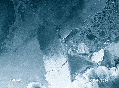
quote:This animation, made up of eight Envisat radar images, shows the 97-km long B-9B iceberg (right) ramming into the Mertz Glacier Tongue in Eastern Antarctica in early February. The collision caused a chunk of the glacier's tongue to snap off, giving birth to another iceberg nearly as large as B-9B.
The new iceberg, named C-28, is roughly 78-km long and 39-km wide, with a surface area of 2500 sq km (the size of Luxembourg).
Since the collision, the two icebergs have drifted together into a polynya, which is an area of open water surrounded by sea ice. Polynyas produce dense, cold, and salty water - known as 'bottom water' - that sinks to the sea bottom and drives ocean circulation.
There is concern that if the icebergs stay in the polynyas area, they could block the formation of the bottom water. This would mean less oxygen going into the deep currents that feed the oceans and would have implications for marine life in the region.
The Mertz Glacier, 72-km long and about 32-km wide, flows into the Southern Ocean off East Antarctica along the George V Coast. It forms a 160-km floating tongue that extends northward into the ocean in the general direction of Australia. The tongue had large cracks (visible) that developed years before the collision.
B-9B broke off the B9 iceberg that calved from the Ross Ice Shelf in West Antarctica in 1987. It drifted westwards and in 1992 ran aground less than 100 km to the east of the Mertz Glacier Tongue, where it has remained until last month. The image to the right shows the positions of the Mertz Glacier Tongue and the B-9B iceberg in December 2007.
The National Ice Center, located in Maryland, U.S., names icebergs that are at least 10 nautical miles (or 19 km) long and are located within a set distance from the South Pole. The names are assigned according to where and when they first broke off from a glacier or ice shelf. The first letter represents one of the four longitudinal quadrants of Antarctica ranging from A to D; quadrant A faces the southern tip of South America, while quadrant C faces Australia.
A sequential number is then assigned to the iceberg, corresponding to how many named icebergs have emerged from a particular quadrant since 1976. So, C-28 was given its name because it is the 28th iceberg to form in the C quadrant.
Envisat's Advanced Synthetic Aperture Radar (ASAR) acquired these images from 10 February to 4 March in Wide Swath Mode, providing spatial resolution of 150 m. ASAR can pierce through clouds and local darkness and is capable of differentiating between different types of ice.
|
|