
De noordoostelijke staten van de USA
De winter in New England staat bekend als een koude winter. De wind is in het winterhalfjaar noordwestelijk en droge arctische lucht uit Canada stroomt ver naar het zuiden. Deze kou-invallen gaan soms gepaard met blizzards. Opdringende warme lucht uit het zuiden zorgt af en toe voor flinke ijzel.
Gemiddeld vriest het bij de Canadese grens in januari zo'n -13 graden. In New Jersey vriest het zo'n 5 graden. In het noordoostelijke puntje van New England daalt in januari de thermometer gemiddeld elke nacht tot -19 graden. De extremen in het gebied liegen er ook niet om. Op 19 januari werd het in Van Buren (Maine) -44,4 graden. Old Forge (New York) mat op 18 februari 1979 zelfs een minimum van -46,7 graden. Het zeewater daalt in januari en februari tot +4 graden in zowel Boston als in New York.
De zuidoostelijke staten van de USA
In de winter komt de gemiddelde kou tot Atlanta. In Maryland, Virginia, de Appalachen en de hoger gelegen staten als Kentucky vriest het veelvuldig. De ergste kou vinden we nog noordelijker in Michigan en Ontario. In West Virginia vinden we de allerlaagste temperatuur van het gebied terug. Op 30 december 1917 daalde in Lewisburg de thermometer tot -38,3 graden.
Het gebied langs de Golf van Mexico beleeft een relatief milde en korte winter. Toch kan het hier soms flink vriezen. Neem bijvoorbeeld de -28 graden die in Corinth (Mississippi) op 30 januari 1966 werd gemeten. In Florida neemt de invloed van de oceaan toe. Dit is vooral merkbaar aan de gemiddelde nachttemperatuur in het zuiden. In zeer uitzonderlijke situatie vriest het hier of valt er sneeuw. Op de Key's komt de temperatuur nooit onder nul. De allerlaagste temperatuur in Florida bedroeg -18,9 graden en werd gemeten in Tallahassee.
De staten Virginia, West Virginia en Maryland krijgen in de winter soms te maken met sneeuwstormen. Deze staan bekend als Nor'easters en komen oktober en april. Ze zijn berucht om de grote hoeveelheid sneeuw, regen en de flinke wind.
Een Nor'easter komt voor als een lagedrukgebied warme vochtige subtropische lucht uit de Golf van Mexico naar het noorden voert. De lucht wordt vermengd met vochtige lucht uit de Atlantische Oceaan. Een hogedrukgebied boven Canada biedt tegenwicht en stuwt arctische lucht naar het zuiden. Daar waar de luchtsoorten bij elkaar komen, ontstaat hevige neerslag.
De meest actieve Nor'easter is de sneeuwstorm die naar het oosten trekt en de straalstroom volgt. Vooral Washington DC, Philadelphia, New York City en Boston worden dan getroffen en krijgen grote hoeveelheden regen en sneeuw te verwerken.
Het midden van de Verenigde Staten
De winters in het noorden zijn streng. Bismarck in North Dakota heeft in januari een gemiddelde temperatuur van -12,7 graden. International Falls op de grens van Canada en Minnesota heeft zelfs een gemiddelde januari-temperatuur van -17,2 graden. De nachtelijke temperaturen bedragen hier gemiddeld -23,3 graden en de dagtemperatuur -11,2 graden.
De staten langs de Canadese grens en de Grote Meren krijgen ook in de winter vaak te maken met 'blizzards', die zeer koude lucht aanvoeren vanuit het arctische Canada. Het gebied is dan bedekt met een sneeuwlaag. Veel is dit niet. In januari valt er slechts enkele tientallen millimeters neerslag.
Veel nachten verlopen helder en de aanwezigheid van een sneeuwdek helpt mee aan een lage temperatuur. De allerlaagste temperatuur in North Dakota werd gemeten op 15 februari 1936. In Parshall werd het -51,1 graden. Op 2 februari 1996 gebeurde hetzelfde in Towar, Minnesota.
Naar het zuiden neemt de strengheid van de winter af. Tot in Kansas is de gemiddelde januaritemperatuur onder nul. In Texas loopt deze snel op. Niet alleen de zuidelijke ligging, maar ook de aanwezigheid van de Golf van Mexico speelt daarbij een rol. In Brownsville op de grens met Mexico is het in januari overdag 20,5 graden en incidenteel boven de 33 graden.
Toch krijgen relatief zuidelijk gelegen gebieden 's winters soms te maken met extreme koude situaties, doordat luchtstromen uit het hoge noorden van Canada hun weg zuidwaarts zoeken tussen de Rocky Mountains en de Appalachen. Zo was het in het ogenschijnlijk warme Texas op 3 februari 1933 in Seminole -30,6 graden.
Westen van de Verenigde Staten
In de winter heerst de meeste kou in de hoger gelegen delen van de Rocky Mountains. Arctische lucht uit Canada zorgt voor strenge winters in het noorden, zoals in Montana, Wyoming en Colorado. In Montana richt de snijdend koude wind geregeld slachtingen aan onder de veestapel. De allerlaagste temperatuur in Montana werd gemeten op 20 januari 1954. Op Rogers Pass werd het toen -56,7 graden onder nul.
In Wyoming waar ook lange strenge winters voorkomen, staat het minimumrecord op bijna -53 graden vorst. Het berggebied van Idao, Utah en Colorado is koud en sneeuwachtig. Vooral in Colorado valt veel sneeuw. Temperaturen tot onder de -50 graden zijn incidenteel mogelijk. De hoogvlakte van Nevada is eveneens koud. In Ely op 1900 meter hoogte vriest het in januari 's nachts zo'n -12,5 graden. Dit wordt tevens veroorzaakt door de vele heldere nachten in het gebied.
Warmer is het in Washington en Oregon. Het kan hier behoorlijk vriezen, maar aan zee is de winter relatief mild. De regen valt vooral tussen oktober en april. In de bergen gaat het dan om sneeuw en worden wegen afgesloten.
In het zuidwesten van Californi� blijft het winters klimaat aangenaam en vriest het zelden. Het is daar dan ook regentijd. Toch kan de winter flink uithalen. Vooral in de Sierra Nevada is dat het geval. De allerlaagste temperatuur in Californi� die is gemeten bedraagt -42,8 graden. In New Mexico tenslotte zijn de winters koel maar niet extreem koud.
Alaska
In de noordelijke Amerikaanse staat Alaska heersen verschillende klimaten. Zeestromingen, bergruggen en een lage zonnestand bepalen voornamelijk het klimaat. In het noorden komen poolwoestijnen voor, in het zuiden heerst een mild klimaat dat vergelijkbaar is met Nederland.
Bron:VWKWEB
De bedoeling van dit Topic is om het winterweer in de V.S. te volgen.
B.v. via onderstaande site's
Winter Weather cnn
Google News
temperatuurkaartje V.S.
temperatuurkaartje Alaska
vorige delen:
Topic Winterweer in de V.S: Snow, Blizzards and Storms (2007)
Winterweer in de VS (2008) - IJsstorm en bar winterweer


De huidige temperaturen in de V.S.

De huidige temperaturen in Alaska

[ Bericht 6% gewijzigd door #ANONIEM op 09-10-2009 19:28:43 ]
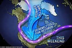
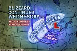
quote:A snowstorm will impact the lives of residents of the Rockies and Plains today into the weekend. Roadways will become treacherous, while there will be flight cancellations.
The coldest arctic air of the season yet is following the zone of snow falling across northern and central portions of the Rockies and Plains. The system dropping the snow and marking the leading edge of the brutally cold air is an Alberta Clipper.
Snowfall will generally be light to moderate, but will still cause very slippery roads with temperatures plummeting below freezing.
The heaviest snow will spread from southwestern Montana and northwestern Wyoming through central Nebraska today into tonight. From 3 to 6 inches of snow will blanket cities and towns within this corridor.
A much more widespread zone from the Rockies into southwestern Minnesota and western Iowa will have a fresh coating of 1-3 inches of snow by Saturday morning.
Following Denver's first flakes of snow Thursday, the city will likely receive its first accumulating snowfall of about an inch that will come down tonight into Saturday.
Motorists traveling across portions of interstates 25, 80, 90 and 94 will encounter dangerous winter driving conditions by late today into Saturday. Gusty winds will add to the dangers by blowing and drifting the snow.
Flights could also be delayed or canceled with the low visibility caused by the falling snow. Airline passengers traveling into or out of Billings, Mont., Cheyenne, Wyo., and North Platte, Neb. could be among those that experience these travel troubles.
Power outages will be less widespread than they were with last week's snowstorm in the northern Rockies and the northern High Plains. A few communities could still endure power outages where the heaviest snow weighs down trees and power lines.
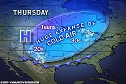
Power outages will not only be a nuisance, but could be very dangerous for residents in this zone. Overnight, some very long-standing record lows may be shattered across parts of the Rockies and High Plains as temperatures plunge into the single digits and teens.
[ Bericht 2% gewijzigd door #ANONIEM op 09-10-2009 14:48:50 ]
Sinds juli in Texas, zomer was warm, maar begint inmiddels behoorlijk af te koelen, vandaag niet boven de 15 graden geweest. Gisteren was het nog wel 30. Ik heb alleen niet echt rekening met koude temperaturen gehouden, dus moet binnenkort maar eens gaan winkelen.
Vannacht kwam er trouwens een behoorlijk stormfront langs. Op de lokale buienradars stond dat er in het noorden en westen van Texas en in rond Oklahoma tornado's waren. Aangegeven met roze vakjes op wfaa.com. Ik dacht altijd dat die alleen in het voorjaar voorkwamen.
quote:Zelfs in Texas kan het knap koud worden.Op zaterdag 10 oktober 2009 02:50 schreef Schuifpui het volgende:
tvp
Sinds juli in Texas, zomer was warm, maar begint inmiddels behoorlijk af te koelen, vandaag niet boven de 15 graden geweest. Gisteren was het nog wel 30. Ik heb alleen niet echt rekening met koude temperaturen gehouden, dus moet binnenkort maar eens gaan winkelen.
Vannacht kwam er trouwens een behoorlijk stormfront langs. Op de lokale buienradars stond dat er in het noorden en westen van Texas en in rond Oklahoma tornado's waren. Aangegeven met roze vakjes op wfaa.com. Ik dacht altijd dat die alleen in het voorjaar voorkwamen.
De temperatuur zakt tot onder de -16 graden.
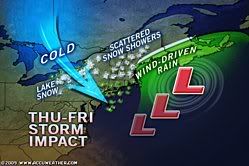
quote:Cold temperatures will persist across the Midwest today.
Snow will continue in parts of the Plains, spreading further north into the Dakotas later today and heading east through the Upper Mississippi Valley tonight and tomorrow.
The heaviest snow is expected in the Black Hills in western South Dakota where over six inches of new snow can be expected.
On the southern end of the precipitation area, rain is expected from the Central Plains through the Mid-Mississippi Valley and the lower Great Lakes through tomorrow night.
A new system is expected to take shape in the Plains Tuesday, bringing more rain and snow to the Plains States before heading east mid to late week.
Highs today will range from the 20s in western South Dakota to the 60s in the Ohio Valley.
Maar ja, dan wel een bizar (groot) land
Yellowstone staat niet apart aangegeven.. met die bronnen daar maakt dat het niet warmer?
quote:Video:Ski�r filmt crash door lawine
HAINES, ALASKA: Een ski�r die zichzelf met een camera filmt in Haines, Alaska, is tijdens de afdaling gegrepen door een lawine.
De sneeuw sleurde hem 150 meter mee naar beneden, waarna hij werd bedolven onder een laag sneeuw. Tien minuten later werd hij uitgegraven van onder de sneeuw, terwijl de camera nog draaide. Wonder boven wonder heeft de ski�r geen botbreuken aan zijn hachelijke avontuur overgehouden, maar wel wat ademhalingsproblemen
http://tf1.lci.fr/infos/i(...)-par-sa-camera-.html
quote:Die heeft geluk gehad.Op maandag 12 oktober 2009 09:39 schreef Frutsel het volgende:
[..]
Video:
http://tf1.lci.fr/infos/i(...)-par-sa-camera-.html
Hier een filmpje. Amerikanen moeten even wennen aan het invallen van de winter.
50-car pileup in first big snow
quote:Het bizarre in de VS is meer dat dit in ��n week tijd op dezelfde plek kan gebeuren.Op maandag 12 oktober 2009 09:33 schreef Frutsel het volgende:
Bizar eigenlijk... -9 en +29 in ��n land
Maar ja, dan wel een bizar (groot) land
Yellowstone staat niet apart aangegeven.. met die bronnen daar maakt dat het niet warmer?
Maar goed, zij hebben geen warme golfstroom..
quote:25 graden celcius in Chicago met kerst, een week later vroor het een paar graden!
[..]
Het bizarre in de VS is meer dat dit in ��n week tijd op dezelfde plek kan gebeuren.
Maar goed, zij hebben geen warme golfstroom..
quote:En in Kenya is er sneeuw en woestijn in 1 landje
Bizar eigenlijk... -9 en +29 in ��n land
Maar ja, dan wel een bizar (groot) land
Yellowstone staat niet apart aangegeven.. met die bronnen daar maakt dat het niet warmer?
Nooit windstil daar en de mega onweersbuien vliegen om je oren in April/Mei... tevens mogelijkheid om in September/Oktober flinke onweersbuien te krijgen! Geweldige staat voor de weerfreaks!
In 24 uur tijd was het ook in Amerika. In Browning Montana daalde de temperatuur van +6.7 naar - 48,8. Een verschil van 55 graden.
weerrecords
[ Bericht 5% gewijzigd door #ANONIEM op 13-10-2009 19:21:06 ]
quote:En dan worden wij met zijn allen ziek als het even een paar graden kouder is.
Grootste temperatuurovergang was in Amerika. Spearfish South Dakota. De temperatuur ging in 2 minuten tijd van -20 naar +7,2 graden.
In 24 uur tijd was het ook in Amerika. In Browning Montana daalde de temperatuur van +6.7 naar - 48,8. Een verschil van 55 graden.
weerrecords
Het schommelt hier nu de hele dag rond het vriespunt met vervelend koude winden. Het meer is ook behoorlijk onstuimig.
quote:Texas morgen 29C.Op dinsdag 13 oktober 2009 20:47 schreef Barcaconia het volgende:
Ik woon aan Lake Michigan. Door de invloed van het water hebben wij een veel kouder en slechter klimaat dan +- 50km landinwaarts. Dit is mijn eerste winter in de USA maar het belooft een slechte te worden. Ik vul mijn kledingkast aan en ik ben benieuwd.
Het schommelt hier nu de hele dag rond het vriespunt met vervelend koude winden. Het meer is ook behoorlijk onstuimig.
quote:
quote:Je hebt daar ook het Lake effect. Depressies over het 'warmere water' van het meer levert dan veel sneeuw op.Op dinsdag 13 oktober 2009 20:47 schreef Barcaconia het volgende:
Ik woon aan Lake Michigan. Door de invloed van het water hebben wij een veel kouder en slechter klimaat dan +- 50km landinwaarts. Dit is mijn eerste winter in de USA maar het belooft een slechte te worden. Ik vul mijn kledingkast aan en ik ben benieuwd.
Het schommelt hier nu de hele dag rond het vriespunt met vervelend koude winden. Het meer is ook behoorlijk onstuimig.
Ik woon letterlijk tegen het lake aan dus het weer is hier het ergst. Het kan hier behoorlijk sneeuwen terwijl ze in de eerste stad landinwaarts nog redelijk normaal weer hebben.
quote:Het maakt toch ook nog uit of je ten westen of oosten van Lake Michigan woont?Op dinsdag 13 oktober 2009 20:47 schreef Barcaconia het volgende:
Ik woon aan Lake Michigan. Door de invloed van het water hebben wij een veel kouder en slechter klimaat dan +- 50km landinwaarts. Dit is mijn eerste winter in de USA maar het belooft een slechte te worden. Ik vul mijn kledingkast aan en ik ben benieuwd.
Het schommelt hier nu de hele dag rond het vriespunt met vervelend koude winden. Het meer is ook behoorlijk onstuimig.
quote:Geen idee, ik woon ten oosten. In de staat Michigan dus.Op woensdag 14 oktober 2009 13:39 schreef JohnnyKnoxville het volgende:
[..]
Het maakt toch ook nog uit of je ten westen of oosten van Lake Michigan woont?
quote:Ah ja, ik sprak een tijdje terug iemand die in Holland, Michigan woont. Die had het letterlijk over "dumping". Inderdaad koude lucht over Lake Michigan die sneeuw aanvoert en alles dumpt in een strook van 20 km. langs het meer.Op woensdag 14 oktober 2009 13:40 schreef Barcaconia het volgende:
Geen idee, ik woon ten oosten. In de staat Michigan dus.
quote:Klinkt leukOp woensdag 14 oktober 2009 13:42 schreef JohnnyKnoxville het volgende:
[..]
Ah ja, ik sprak een tijdje terug iemand die in Holland, Michigan woont. Die had het letterlijk over "dumping". Inderdaad koude lucht over Lake Michigan die sneeuw aanvoert en alles dumpt in een strook van 20 km. langs het meer.
Ik woon niet ver van Holland af. Leuk stadje trouwens
quote:Ik denk dat de meeste sneeuw ten oosten van de meren valt. De depressies komen meestal vanuit het noorden/westen.Op woensdag 14 oktober 2009 13:39 schreef JohnnyKnoxville het volgende:
[..]
Het maakt toch ook nog uit of je ten westen of oosten van Lake Michigan woont?
quote:Ik zal jullie met foto's op de hoogte houden als het begint.
[..]
Ik denk dat de meeste sneeuw ten oosten van de meren valt. De depressies komen meestal vanuit het noorden/westen.
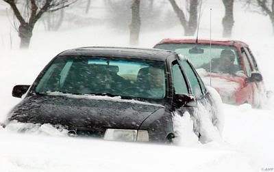
quote:DENVER (AP) -- An early blast of winter walloped some western states with deep snow and slowly pushed into Nebraska and Kansas Thursday, bringing blizzard conditions to the eastern plains and causing treacherous roads, closed schools and hundreds of canceled flights.
The fall storm spread 3 feet of snow and left much higher drifts across parts of northern Utah, Wyoming and Colorado, before its leading edge hit neighboring states just to the east.
Wind-driven snow built to blizzard conditions over much of eastern Colorado. The weather service warned most area roads would be impassible Thursday night because of blowing snow and near-zero visibility.
The heaviest October snowfall in the Denver area in a decade forced the closure of hundreds of schools and businesses. Roads across the region remained snowpacked and icy.
"Big storms like these, they seem to come around every 10 to 12 years," said Kyle Fredin, a National Weather Service meteorologist.
Denver-based Frontier Airlines said it canceled 44 flights in and out of Denver International Airport. Other flights were delayed by up to four hours. United Airlines, the airport's dominant carrier with about 400 flights per day, canceled half its flights Thursday to prevent delays and cancelations from spilling over into Friday, spokesman Charlie Hobart said. Both airlines planned to operate full schedules Friday.
Airport spokesman Chuck Cannon said crews were using 174 pieces of snow-removal equipment to keep runways and taxiways clear as they dealt with severe wind gusts. Cannon said two departure and two arrival runways were open. The airport received at least 16 inches of snow with 5-foot snow drifts east of Denver, the weather service said.
The Colorado Department of Transportation closed a 140-mile stretch of Interstate 70 from near Denver to Burlington and 55 miles of Interstate 76 from Lochbuie to Fort Morgan. Plows struggled to keep up with the blowing snow, said CDOT spokesman Bob Wilson.
No serious accidents were reported, likely because shuttered businesses meant fewer cars on the road, Wilson said.
In Wyoming, road closures included a 40-mile stretch of Interstate 80 from Cheyenne to Laramie; a 35-mile span of Interstate I-25 from Wellington to Cheyenne; and a 200-mile stretch of I-80 west of Big Springs to Laramie, Wyo. Snow drifts were running up to 4 feet in Cheyenne and up to 6 feet 30 miles north of the city.
quote:Hmm Denver, daar ben ik over 2 maanden. Hopelijk dan wat beter weer daar. Wij moeten ook over de I70 en vliegen met Frontier van en naar Denver.
Video van The Weather Channel
[ Bericht 44% gewijzigd door #ANONIEM op 01-11-2009 13:46:45 ]

quote:The first big snowstorm of the season hit Colorado in the last week of October 2009. Hundreds of flights were cancelled at Denver International Airport, and interstate highways leading from Denver to Kansas, Nebraska, and Wyoming were closed due to blizzard conditions. Some locations in Colorado, Utah, and Wyoming received several feet of snow.
Sunny skies on October 31, 2009, allowed the Moderate Resolution Imaging Spectroradiometer (MODIS) on NASA’s Aqua satellite to capture this view of the whitened landscape. Snow highlights the rugged mountains as well as the urban and agricultural landscapes of the plains. Denver appears as a grayish patch near image center, and a broad swath of snow sweeps eastward to the Kansas state line. The patchwork of fields and pastures that dominates the Colorado plains is most obvious around the margins of the snowy areas.
quote:Another premature blast of winter is right around the corner for the Northeast with frigid winds for many and even some snow for a few.
Cold air will arrive tonight into Friday, in the wake of chilly rain and even sleet and snow running across Upstate New York and northern New England.
A storm will strengthen off the Northeast coast Thursday night into Friday.
The brunt of the potent storm will slam Down East Maine and Atlantic Canada.
On the front side of the storm, winds over eastern New England could be strong enough to cause tree damage and power outages.
Gusty winds blowing on the storm's back side Thursday over the Great Lakes will spread through the mid-Atlantic by Friday. Gusts could top 50 mph in some areas; strong enough to cause sporadic power outages once again.
AccuWeather.com RealFeel� temperatures will drop into the teens and 20s throughout the Northeast Thursday night.
Winter attire is recommended for those venturing out, even in Boston, New York City, Philadelphia, Baltimore and Washington, D.C.
Enough cold air will arrive that snow also falls across parts of the Northeast Thursday night into Friday.
A coating to an inch of snow Thursday night could create slippery roads in the mountains of northern Pennsylvania, New York and central New England.
Only a few wet snowflakes will make an appearance in the northern and western suburbs of New York City.
Vanavond aan de turkey, maar hoe staat het ervoor met de winter in de VS? Hier in Texas is het overdag nog rond de 20 graden, 's nachts zo'n 4 graden de afgelopen dagen. Ik heb ook al vorst gezien op autoruiten, daken en gras. Eigenlijk voelt het behoorlijk koud aan. Vandaag voor het eerst de verwarming aangezet, huizen zijn toch wel iets minder ge�soleerd dan in Nederland, het was net maar 13C binnen.
quote:Komende dagen wordt het kouder en vrijdag verwachten ze droge sneeuw. Toch niet echt verwacht toen ik 5 maanden geleden m'n koffers pakte om vanuit Nederland hier naar toe te komen.... SIGNIFICANT WEATHER ADVISORY...
MODERATE SNOW IS OCCURRING ACROSS THE REGION AND WILL CONTINUE THROUGH THE MID MORNING HOURS. ACCUMULATION OF 1 TO 2 INCHES ON ELEVATED OR GRASSY SURFACES WILL BE POSSIBLE. SOME SNOW ACCUMULATIONS ON ROADWAYS IS POSSIBLE... WHICH MAY IMPACT TRAVEL THIS MORNING. ALTHOUGH ROAD SURFACES ARE STILL WARM AND MUCH OF THE SNOW IS MELTING... MOTORISTS SHOULD EXERCISE CAUTION WHEN TRAVELING THIS MORNING. CONDITIONS WILL IMPROVE DURING THE MID MORNING HOURS AS TEMPERATURES WARM.
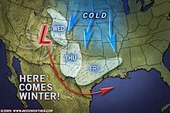
quote:Soon after people in the Northeast deal with heavy rain, delays and flooding problems from a storm Wednesday into Thursday, the track of a second and colder storm this weekend could bring snowfall to a heavily populated area in the mid-Atlantic.
It may be time to locate your snow brush and snow shovel if you live in the corridor from Roanoke to Philadelphia
Forecast problems still remain with a second storm forecast to bring heavy snow to the Houston, Texas, area Friday.
For now, the most likely area to receive several inches of snow lies from southwestern Virginia to southern New Jersey.
Computer models have trended farther south and east over the past 24 hours, and this trend will have to be watched for any more shifts in that direction or the reverse.
A difference in storm track by as little as 100 miles could mean no snow at all and the band of heavy snow falling somewhere else.
One thing to keep in mind is just because heavy rain falls with the first storm Wednesday into Thursday that does not mean the second storm this weekend will do the same.
Additionally, in the wake of the rainstorm and the potential snowstorm, lake-effect snow can bring bands of heavy snowfall to the lee of lakes Erie and Ontario later Thursday into Friday and again Saturday night into Sunday.
More storms and cold outbreaks will follow as the "December to remember" is just getting underway.
Niet alleen wij kijken uit naar de sneeuw.
In Amerika zijn alle ogen dit weekend gericht op het zuiden van het land. In de stad Houston, Texas, is vandaag de vroegste sneeuwdag genoteerd in de geschiedenis van de stad. Niet voor te stellen als je weet dat deze regio zich normaal druk maakt over orkanen en andere tropische overlast. Ook elders in de VS is het koud. Tot aan de grens met Mexico vriest het ook overdag.
Kou verscherpt zich
De komende dagen wordt het nog een stuk kouder.
Eerst neemt de kou in het zuiden wat af, maar ten zuiden van Alaska ontstaat op dit moment een krachtig hogedrukgebied. Aan de oostflank hiervan wordt vanuit Canada de komende dagen �chte diepvrieskou op transport gezet naar het zuiden. Dan hebben we het over middagtemperaturen die niet boven -10 graden uitkomen. In een groot deel van Canada blijft het volgende week overdag gewoon meer dan 20 graden vriezen. Hieronder het GFS-ensemble voor de Canadese stad Edmonton. Het toont de temperatuur op zo’n 1500m hoogte, de rode lijn laat de normale temperatuur zien.
De kou trekt vervolgens naar het oosten waar een actieve depressie uiteindelijk voor een winters feestje kan gaan zorgen. Naast de kou moet de omgeving rond New York en Washington in de loop van de week namelijk rekening houden met een dik pak sneeuw. Saillant detail is dat Houston tegen die tijd alweer met 20 graden van de zon kan genieten. (wintersport.nl)
quote:
Het sneeuwt in Texas!
[..]
Komende dagen wordt het kouder en vrijdag verwachten ze droge sneeuw. Toch niet echt verwacht toen ik 5 maanden geleden m'n koffers pakte om vanuit Nederland hier naar toe te komen.Ik heb ook niet echt veel warme kleding mee.

De winter lijkt definitief te zijn ingevallen. Flinke sneeuw in een groot deel van de VS. De sneeuw in DFW, Texas vrijdag is uitgebleven. Vanmiddag wel een paar natte sneeuwvlokken gehad nog. Morgen weer 16 graden, daarna iets kouder.
Over twee weken vertrekken we op roadtrip, eerst Colorado, dan Arizona en Utah, vervolgens Nevada en dan California. Hoop dat er niet al te veel sneeuw valt onderweg.

quote:Frigid air driven by 40- to 60-mph wind gusts will spread snow and falling temperatures farther to the east over the Midwest into tonight, leading to deteriorating travel conditions, including a freeze-up on roads and sidewalks.
While travel conditions improve over the southern Plains, conditions are getting worse farther northeast over the Upper Midwest as cold air is being pulled in by strong winds.
Temperatures are falling below freezing in Chicagoland as a burst of snow rolls through. Roads may quickly turn slushy and snow covered in some areas where rain washed away the previous snow or places where the snow was cleared.
These same conditions will roll into Detroit, Indianapolis and Cleveland into this evening.
Winds gusts up to 60 mph will continue to shift eastward through the Ohio Valley into tonight and can lead to power outages, downed trees and minor property damage.
Some arriving flights at the Minneapolis-St. Paul International Airport are being delayed by several hours due to high winds and blowing snow.
Drifts of up to 4 feet are piling up on the storm's back side as powerful winds push powdery snow around. The blowing snow is leading to low visibility at times, even after snow stops falling from the clouds.
Cities subject to the blowing and drifting snow include Omaha, Des Moines and La Crosse, Wis.
Officials are currently advising motorists not to travel on interstates 29, 35 and 80 through Iowa. A similar statement could be made to travelers across neighboring states and Michigan.
quote:Ik zat er midden in

quote:A severe winter storm blustered its way across the United States on December 7 and 8, 2009. The storm dumped heavy snow from California to the Great Plains, and fierce winds added to the hazardous conditions. The storm was predicted to continue eastward in midweek, and blizzard warnings were in effect for Great Lakes states as of December 9.
rest van het artikel

quote:Hopelijk eind volgende week ook in ons land van die winterse taferelen. Weliswaar zonder slachtoffers danDES MOINES, Iowa — A gigantic storm dumped more than a foot of snow across much of the Midwest and New England as it marched eastward Wednesday, creating blizzard conditions, burying cars under huge drifts and providing ammunition for a massive campus snowball fight in Wisconsin.
Even more snow fell in some areas, with 16 inches reported in Des Moines and nearly 19 inches just south of Madison, Wis. Gusts of up to 50 mph created snow drifts between 8 and 15 feet tall and even knocked down a two-story Christmas tree in downtown Champaign, Ill.
The storm was blamed for at least 16 deaths, most in traffic accidents. Hundreds of schools canceled classes, power was knocked out to thousands of people from Missouri to New York and hundreds of flights were canceled.
In the Twin Cities, where about 6 inches of snow fell and the wind chill dipped to minus 9 degrees, Kent Barnard eased a massive orange snowplow into traffic in the suburb of Arden Hills on Wednesday morning. He dropped the right wing of the plow down onto the shoulder, making a grinding sound as the wing sent out a spray of snow.
"You gotta watch it because some people try to sneak up around you," Barnard said. "They'll see that big orange flashing truck coming and go, 'I don't want to get caught behind that thing."'
Rest of story: click here
quote:Hollanders kennende zal er wel weer een heel leger dode lease rijders te betreuren zijnOp donderdag 10 december 2009 14:54 schreef Frutsel het volgende:
[ afbeelding ]
[..]
Hopelijk eind volgende week ook in ons land van die winterse taferelen. Weliswaar zonder slachtoffers dan
quote:Crippling Lake-Effect Snow Event Underway
In the wake of the fierce coast-to-coast storm, blustery winds have greatly activated the lake-effect snow machine across the Great Lakes. Towns and cities will become crippled by the snow, which will persist through at least Friday and will need to be measured with a yardstick.
The Northeast Regional Radar shows the beginning stages of this extremely significant lake-effect snow
Between 1 to 3 feet of snow will bury places to the lee of lakes Superior, Erie and Ontario, as well as Georgian Bay through at least Friday. It is not out of the question that the snow will amount to 4 feet.
Snowfall rates may reach a couple of inches per hour within the most intense bands throughout the Great Lakes. Road crews will likely have trouble keeping streets and highways clear.
Blustery winds will not only make measuring the snow difficult, but will add to the severity of the situation.
Localized whiteouts will result as the winds severely whip the snow around. Drifting snow may make some roads impassible.
Motorists should prepare for treacherous travel and potential road closures on the New York State Thruway (I-90) through southwestern New York, I-81 in upstate New York, I-196 and I-94 in southeastern Michigan.
An end to this intense lake-effect snow event will finally come Friday night into Saturday as the snow tapers off from west to east.
[ Bericht 3% gewijzigd door #ANONIEM op 10-12-2009 20:27:26 ]
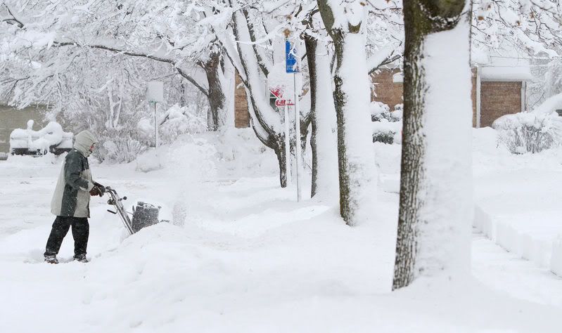
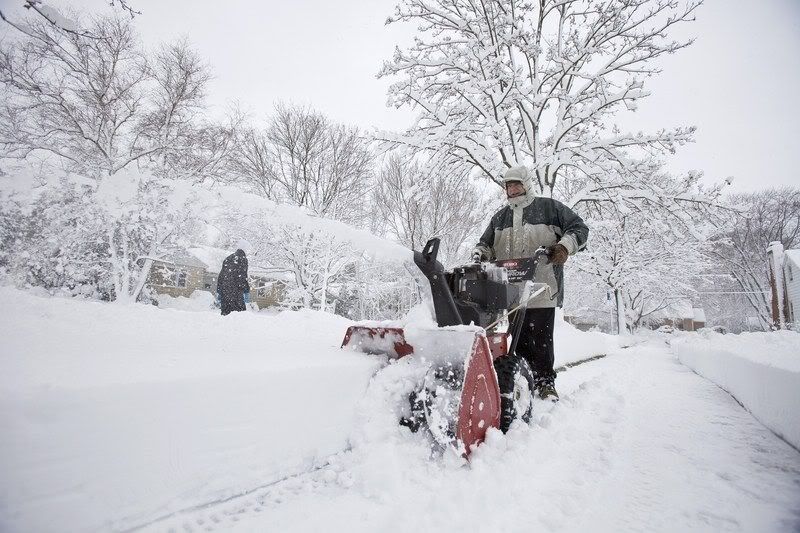
quote:In het centrum van de Verenigde Staten zijn woensdagnacht en donderdagochtend zestien mensen om het leven gekomen bij ongevallen die het gevolg waren van hevige sneeuwstormen. Dat melden verschillende media. Er wordt de komende dagen overigens nog meer sneeuw verwacht.
Slachtoffers
De meeste slachtoffers vielen bij verkeersongevallen. In delen van het Midwesten viel tot ��n meter sneeuw, waardoor de meeste scholen, universiteiten en openbare gebouwen gesloten moesten worden. Verschillende luchthavens moesten eveneens de deuren sluiten, en er worden ontzettend lange files waargenomen.
Krachtige sneeuwstorm
Dergelijke stormen zijn tijdens deze periode van het jaar niet ongewoon in dat deel van de VS. Een meteorologe van de National Weather Service, Penny Zabel, zei aan The New York Times dat het een bijzonder krachtige sneeuwstorm betreft.
Overstromingen
In het zuiden van het land zorgde de storm eveneens voor regen en overstromingen. (belga/vbd)
hln
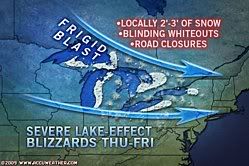
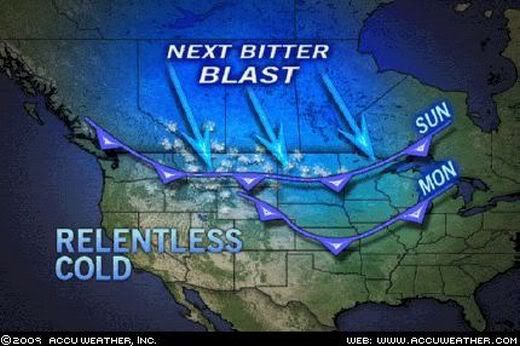
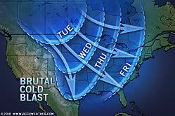
quote:Europa raakt in de ban van de kou, in de VS is dat proces al volop gaande. International Falls, Minnesota rapporteerde vandaag -26,7 en North Platte, Nebraska -27,8� (28 november nog 20,6�) en de 'next bitter blast' van arctische kou uit Canada is onderweg. Dinsdag wordt voorlopig het dieptepunt verwacht met in de noordelijke staten maxima beneden -18�. Door de wind doet het nog veel kouder en is het ronduit gevaarlijk om lang buiten te zijn. Het onderstaande kaartje (bron: AccuWeather) laat aan duidelijkheid niets te wensen over.
jan visser
quote:Tell me about it.Europa raakt in de ban van de kou, in de VS is dat proces al volop gaande.
Achterkant van 't huis, mooi hoe de sneeuw over het dak heen 'hangt'.

quote:Heftig storm weekendje voor de VS op komst?Heads up for folks who have interests along the Mid-Atlantic coast- major coastal storm coming up this weekend with more beach erosion and overwash possible. Looks like a significant snow storm too for interior portions of the region.
quote:61 cm sneeuwSnowblanket in US East Coast
A snowstorm has blanketed the United States East Coast and the country's National Weather Service has forecast up to two feet (61 centimetres) of snow will fall on and around Washington DC over the weekend.
Mayor Adrian Fenty has declared a snow emergency in the Washington area, saying "all indications are this will be a major storm - perhaps the biggest we've seen in several years".
In Virginia, Governor Tim Kaine declared a state of emergency.
Winter storm warnings were in effect from North Carolina and Tennessee in the south to southern New England in the north.
The weather service said travel conditions throughout the region would be "extremely treacherous".
The storm was expected to pass through the mid-Atlantic region by early Sunday (local time), blanketing areas to the north including Philadelphia and New York City during the weekend.
Snow was expected to start falling in New York by mid-afternoon on Saturday, with accumulation of 15 to 30cm by noon Sunday.
Authorities were urging drivers to stay off the roads.
Airports in the Washington area including Dulles International and Reagan National were open but officials have advised travellers to check their flights with airlines.
The snowstorm, predicted to dump more snow on the region than any storm since at least February 2003, was expected to take a big bite out of retail sales on the last weekend before Christmas, traditionally one of the busiest of the year.
quote:BreakingNews
United Airlines cancels 500 flights, mostly in and out of D.C. airports, due to East Coast storm – NBC
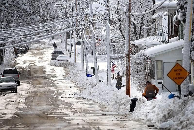
WASHINGTON - De ernstigste sneeuwstormen in jaren hebben zaterdag het openbare leven in grote delen van de Amerikaanse oostkust stilgelegd. Bij honderden ongelukken kwamen zeker drie mensen om het leven.
In North Carolina en de staten ten noorden daarvan tot en met Pennsylvania lag soms een pak sneeuw van meer dan een meter.
In de hoofdstad Washington riep burgemeester Adrian Fenty de noodtoestand uit.
Obama
President Barack Obama was zaterdagochtend net op tijd terug van de klimaattop in Kopenhagen om veilig te kunnen landen op de militaire luchthaven Andrews in de staat Maryland.
meeste luchthavens in de buurt bleven wegens het slechte weer gesloten. Vluchten uit en naar de hoofdstad werden geannuleerd.
Stroomuitval
Ook in de steden Baltimore en Philadelphia kwam het openbaar leven tot stilstand. Scholen en universiteiten bleven dicht Op het platteland zitten tienduizenden mensen zonder stroom.
In de supermarkten zijn veel schappen leeg, omdat klanten het slechte weer hebben zien aankomen en drank en voedsel hebben gehamsterd.
� ANP
nu.nl
quote:hln60 cm sneeuw in VS
Ook in de Verenigde Staten zal extreem winterweer de kerstplannen van veel mensen verstoren. In het noorden van het land zal naar schatting 60 centimeter sneeuw vallen. Het zuiden krijgt dan weer te maken met hevige regenval. Er werd zelfs een tornado gesignaleerd. Ook op veel Amerikaanse luchthavens viel het vliegverkeer stil. Er vielen al zeker 18 doden door het extreme weer in de VS. (gb)
quote:Kolossale storm trekt over midden VS
Grote delen van de VS zijn donderdag getroffen door een zeer zware sneeuwstorm
Zeker negentien mensen kwamen om door de slechte weersomstandigheden in onder meer Nebraska, Kansas en Arizona. De nationale weerdienst (NWS) waarschuwde voor hevige sneeuwstormen in onder andere North en South Dakota, Wisconsin en Minnesota.
,,Er trekt een kolossale storm over het midden van het land, van de noordelijke Canadese grens tot het zuidelijke Texas en van Colorado tot Illinois'', zei een woordvoerder van de weerdienst. ,,De storm spreidt zich uit over twee derde van het land.'' De ijskoude regen in combinatie met stormachtige wind maakt de weg opgaan volgens hem extreem gevaarlijk. Tientallen kerkdiensten op kerstavond gingen niet door.
Het gure winterweer begon woensdag en houdt naar verwachting aan tot zaterdag.
Bron Trouw
[ Bericht 0% gewijzigd door #ANONIEM op 25-12-2009 11:40:51 ]
In de Amerikaanse staat Oklahoma is de noodtoestand afgekondigd in verband met de zware sneeuwstorm die het midden van het land teistert. Zo'n tien staten gaan gebukt onder het slechte weer.
De autoriteiten in verschillende staten hebben vliegvelden afgesloten, waardoor veel vakantievluchten niet doorgaan.
In North Dakota, South Dakota en Texas zijn veel snelwegen dicht. Bij ongelukken in het verkeer zijn zeker 19 mensen om het leven gekomen. De wegen zijn spekglad en het zicht is minimaal door de sneeuw.
In Montana is het 34 graden onder nul.
De storm in de VS, de zwaarste in jaren, trekt nu naar het oosten.
nos
quote:In Engeland praten ze ook al over de Big Freeze... Hier is het koud en ongewoon veel sneeuw... net als in Oost Europa, Moskou en nu ook China en India. Heel het Noordelijk halfrond gaat gebukt onder kou enzo ^^Freezing weather worsens: there is more to come
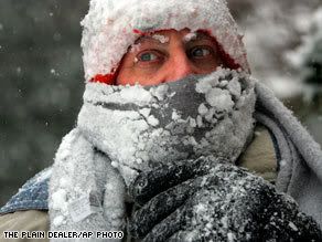
Much of the nation awoke to frigid weather Monday as below-freezing temperatures threatened to shatter records across the South.
"We're seeing freeze warnings not just into Central Florida, but down into the Everglades," CNN meteorologist Rob Marciano said.
Hard freeze warnings were in effect for much of the Florida Peninsula and the Southeast, according to the National Weather Service. Record lows were expected in the Gulf Coast states and into southern Florida, said CNN meteorologist Sean Morris.
Temperatures in parts of South Carolina got down to 14 on Sunday, Morris said, breaking the record low of 18 set in 1979.
The Big Chill is far from over.
"More arctic air will move in this week," Morris said. "It will get progressively colder in the Southeast."
"Some locations could see temperatures 30 to 40 degrees below normal" across parts of the Plains, upper Midwest and Ohio River Valley on Thursday, Morris said. By Friday morning, afternoon highs will struggle to make it above zero, he said.
"The main event will come whenever the reinforcing cold air moves in," Morris said.
In Minneapolis, Minnesota, the temperature was minus 7 Monday morning, Morris said. In Chicago, Illinois, it was 11, with a wind chill of 3 below zero.
weak storm system will move rapidly eastward across the Gulf Coast states Thursday and could bring a dusting of snow to Birmingham, Alabama, and Atlanta, Georgia, Morris said.
Florida was monitoring the cold's impact on crops, according to John Cherry, director of external affairs for the state's Division of Emergency Management.
"We'll be getting some data today on what the impact is," Cherry said Monday. The state began warning residents last week to take precautions. "We saw this coming," he said.
A winter storm watch was in effect for parts of central North Dakota, which was expected to experience moderate to heavy snowfall, the Weather Service said.
The cold meant more homeless people were seeking shelter, according to CNN affiliate WBIR in Knoxville, Tennessee.
Two hundred guests have shown up at Knox Area Rescue Ministries, which was built to house 100 people, according to WBIR. "When it gets this cold it means it's extra demands on what we do day in and day out," Rescue Ministries President Burt Rosen told WBIR
quote:Nearly the entire eastern half of the United States is enduring bitterly cold temperatures not experienced since 1985. Even Florida, which has been hovering around freezing levels overnight recently, is also feeling the almost-nationwide chill.
"It'll be like the great winters of the '60s and '70s," said AccuWeather.com Chief Meteorologist and Expert Long Range Forecaster Joe Bastardi.
The last time a large swath of severely low temperatures struck the nation was in January 1985. That historic arctic outbreak had below-zero temperatures Fahrenheit stretching from Chicago eastward to New York City, and all the way south to Macon, Ga.
While Bastardi says the upcoming days will bring cold not seen since 1985 or 1982, he believes this winter is shaping up much that of like 1977-78. That winter, nearly all of the United States east of the Rockies had a cold October followed by a warm November, with the cold returning in December.
What is most interesting in this case is what followed, where the months from January through March can all be classified as very cold, relative to normal.
"If it stays this cold for this long, will the groundhog even want to come out on Feb. 2?" wonders Senior Vice President and Chief Meteorologist Elliot Abrams.
This winter has already been rough for many areas of the country, with several blizzards dumping high accumulations of snow upon the Plains, mid-Atlantic and New England.
The cold air currently streaming across the Upper Midwest into the East and South will only compound the winter problems of the nation, especially since these depths have not been experienced across such a wide area simultaneously in decades.
Over the past 20-plus years, when below-normal cold periods have arrived in the winter they tend to have been limited to one region, according to Bastardi.
Temperatures have not been this low since the winter of 2002-03, which is known as the benchmark for frigid conditions in the last decade. However, that year the cold was not as widespread as what is happening now.
With the entire eastern half of the country in the throes of this arctic snap, this is shaping up to be the coldest winter in many people's memories.
(Nog geen week geleden gaf hij overigens -14F aan, 's ochtends in Arizona.
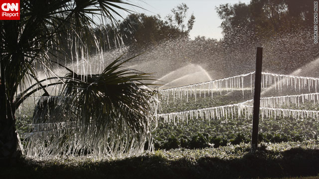
quote:daar gaat de sinaasappeloogstThermometer in Miami op laagste punt in tien jaar
Een polaire koudegolf heeft de stad Miami en heel het zuiden van Florida laten bibberen, met temperaturen van rond het vriespunt, iets wat de afgelopen tien jaar in de Sunshine State niet meer werd geregistreerd.
De ijskoude wind dwong de lokale autoriteiten afgelopen nacht tot het inrichten van noodverblijven voor de daklozen in openbare gebouwen van de districten Miami-Dade en Broward. De beroemde stranden van Miami Beach lagen er verlaten bij, terwijl de normaal schaars geklede toeristen voor ongewone beelden zorgden door zich te hullen in dikke mantels, sjaals en mutsen.
Het was van 2001 geleden dat het nog zo koud was in Miami, toen temperaturen tussen de 1 en 5 graden Celsius werden gemeten, aldus de plaatselijke weerdiensten, die zeggen dat het kwik morgen nog verder zal dalen.
quote:Goed voor Dubai.Oil rises to near $82 on stocks, cold weather
Florida.

daar gaat de sinaasappeloogst van 9 miljard als het zo doorgaat:{
quote:Die Amerikanen hebben toch van die triplex huisjes? Die zullen flink wat verstoken dan
http://www.weeronline.nl/(...)Staten/Miami/3908604
quote:Ik zie op het kaartje links toch echt -17 staan hoor.Op donderdag 7 januari 2010 15:43 schreef Saekerhett het volgende:
Ben ik nou gek, of zijn die koude temperaturen in Miami op de weertabellen niet terug te zien:
http://www.weeronline.nl/(...)Staten/Miami/3908604
quote:
Ben ik nou gek, of zijn die koude temperaturen in Miami op de weertabellen niet terug te zien:
http://www.weeronline.nl/(...)Staten/Miami/3908604

Miami ligt net ten zuiden van het vorstgebied. (denk ik)
quote:Pak een betrouwbare site en je ziet het. Die NL weersites zitten er nog wel eens naast qua buitenlands weer.Op donderdag 7 januari 2010 15:43 schreef Saekerhett het volgende:
Ben ik nou gek, of zijn die koude temperaturen in Miami op de weertabellen niet terug te zien:
http://www.weeronline.nl/(...)Staten/Miami/3908604
quote:Pythons and citrus and iguanas, oh my! Frigid Florida copes
(CNN) -- Ordinarily a sunny playground that mocks the rest of winter-suffering America, Miami, Florida, was in sore need of a giant Snuggie on Sunday.
There wasn't a scantily clad beautiful person at any of the outside tables at South Beach's tony Balans restaurant. Everyone was crammed inside to assuage their Saturday nights with pancakes and Cuban coffee, chuckling at the heat lamps that waiters had scrambled to put up outdoors.
"Yeah, the lamps were not so good. So we brought inside all the tables to make sure our customers could manage," said manager Mike Fernandez. "I'm from Chile and living here, you know, it's not supposed to be like this."
Temperatures in Miami barely got into the 40s on Sunday; normally, they'd be in the 70s.
Cold is so relative. In Aberdeen, South Dakota, the thermometer registered a low of 31 below zero Sunday. Connecticut officials opened shelters in anticipation of bitter cold. Following a rare snowfall last week in Atlanta, Georgia, temperatures hovered in the teens and drivers lacking snow savvy skidded around very small patches of ice. How is the weather where you are? Share your pictures or video
But the biggest news about the big chill is coming from the northern part of Florida, where a hard freeze watch is in effect, CNN's meteorologist Bonnie Schneider said. That could be bad news for citrus trees that rarely survive when temperatures remain in the mid-20s or below for four hours or longer, according to Kristen Gunter, a spokeswoman for the association of companies that pick and process the oranges.
Florida citrus is a $9.3 billion industry. The state produces three-quarters of the United States' orange crop and 40 percent of the world's orange juice supply.
"[Sunday night] will be the night to watch, because if things don't go well, the entire economy will be affected, jobs could be lost if fruit on the ground cannot be harvested, workers will go elsewhere in the U.S., and Florida will lose," Gunter said.
The citrus harvest is at its peak right now, she said, and workers are already grinding away seven days a week as it is. "I'm not sure we can work any faster," Gunter said.
University of Florida wildlife biologist Dr. Frank Mazzotti was also working feverishly on Sunday. As part of an ongoing project, he and other scientists are working to euthanize iguanas, a non-native species that can disrupt the ecosystem. Cold weather makes his job easier: When temperatures drop, the iguanas, many up to 6 feet long, go into into a stunned, catatonic state, stiffen and fall to the ground from tree branches and other perches.
The freeze is also going to be a test for the area's most unwelcome beast -- the Burmese python. The snakes have no natural predators and have been threatening the Everglades, the general ecosystem and even people since they were introduced to Florida through the illegal exotic animal trade, Mazzotti said.
The problem was graphically driven home in October 2005 in Everglades National Park, when wildlife researchers photographed a dead, headless python. It had apparently exploded while trying to swallow a 6-foot-long alligator. Lighter nibbles for pythons include native birds and other crucial members of the ecosystem.
"If pythons survive this cold, then that's going to tell us what a challenge it will be to get rid of them," Mazzotti said, adding that his team inserted transmitters on 10 of the snakes and will be monitoring them tonight.
More popular creatures at the Miami Metrozoo are huddling under extra blankets. Ron Magill, zoo spokesman, said staffers removed chimps, gorillas and other primates from their cages Saturday and placed them in little beds with blankets, which of course they ripped.
"They did a little of that but it keeps them warm," he said.
Galapagos tortoises and Komodo dragons were also kept warm. And while the zoo closed for the first time in 30 years due to cold, it reopened Sunday with everyone at the ready to bundle the animals up again and shut the zoo if necesesary.
quote:die sinaasappelsDeepfreeze continues.... but ?
The Deep South shivered through a ridiculously frigid weekend, with low temperature records crumbling over much of Florida, Texas, and Louisiana. This morning, record lows for the date fell in Miami, West Palm Beach, Tampa, Fort Myers, Lakeland, Tallahassee, and St. Petersburg. The most extreme low temperature record this morning was set in Key West, where the mercury fell to 42�F at 5am--the second coldest temperature ever observed in Key West. This is just 1� warmer than the all-time coldest temperature observed in Key West--41� in January of 1981 and 1873. Widespread reports of sleet and snow flurries accompanied the cold blast across Central Florida on Saturday, the eighth snow event in Florida since 2000, according to Wikipedia. It remains to be seen how much damage the $9.3 billion Florida citrus industry will see because of the cold blast, which is the most severe in Florida since the December 1989 cold wave that devastated the citrus industry. Temperatures below the 28� that causes fruit damage affected some citrus-growing areas again this morning, for the third consecutive morning.
Intense and long-lasting cold
In Texas, two airports tied all-time January low temperature records on Saturday morning--Hondo, who's 12�F tied the record set January 11, 1982, and Cotulla La Salle, which hit 16�F, tying the record set January 13, 1975. Most of Texas' airports set daily low temperature records on Saturday morning. Saturday's low in Waco of 8�F broke the previous record of 15� for the date, and was the first time Waco has been in the single digits since the -4�F reading on December 23, 1989. Not only has the South's cold been intense, it has been exceptionally long-lasting. Montgomery, Alabama has had a low temperature below 25� nine consecutive days, breaking the old mark of seven straight days set in January 2001. With the cold snap only grudgingly scheduled to release its grip on the South, Montgomery can expect to run their streak of sub-25� lows to at least eleven straight days this week. Mobile, Alabama and Pensacola, Florida now have their second longest streak of days with a minimum temperature below freezing, at nine and eight days, respectively. Pensacola may equal or top their record of eleven straight days (set in January 1940) later this week, but Mobile is unlikely to break their record of fifteen straight days (set in February 1940). Also of note is that Key West has seen five consecutive days with low temperatures below 50 degrees (January 7th - 11th). This is the second longest such streak recorded in Key West, one day short of the record six-day streak on December 1 - 6, 1876. Key West has a decent chance of tying that record on Tuesday morning, when the low should fall to 50 or below.
nicer beach weekend in Antarctica than Central Florida
Saturday's high and low temperatures in Orlando and Daytona Beach, Florida were 40� and 30�F. Tampa's high and low were 42�F and 29�F. Under sunny skies and light winds less than 10 mph, Saturday's high and low temperature at San Martin Base, Antarctica were 44� and 34�F. Gray, cloudy skies with winds gusting to 16 - 21 mph greeted beach goers at the beaches near Daytona Beach and Tampa, so it was a much nicer day at the beach in the Antarctic Peninsula than in Central Florida on Saturday (the Florida Chamber of Commerce loves stats like that!) Nicer beach weather in Antarctica than Central Florida continued through Sunday, with sunny San Martin, Antarctica (high 41�, low 35�) recording an average temperature warmer than most stations in Central Florida. In all fairness, it is summer in Antarctica, and the ocean temperatures in Florida were a bit warmer than in Antarctica.
A major pattern shift coming
As I noted in my previous post, a sharp kink in the jet stream and a strong negative phase of the North Atlantic Oscillation is responsible for this winter's cold blast over eastern North America and Europe. The ridge of high pressure that has been blocking the west-to-east motion of weather systems over the past ten days is weakening, though, and a major shift in the winter weather pattern is in store for the Northern Hemisphere by late this week. A more typical El Ni�o pattern will set up, with the jet stream diving southward over California, bringing a strong flow of moist, Pacific air to the West Coast. A strong low pressure system will also bring heavy rain to the Gulf Coast on Friday and Saturday. Temperatures will slowly moderate across Europe and the Midwest and Eastern U.S. this week as the pattern gradually shifts, and more ordinary winter weather can be expected in these regions by next weekend.
quote:Frozen OJ
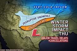
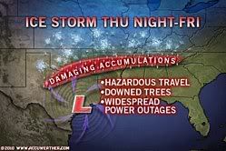
quote:Major Winter Storm Starts Thursday in the Southern Plains
A storm rolling out of the Four Corners region with snow, ice and rain is set to disrupt lives and travel from the southern Plains to the mid-South and the mid-Atlantic over the balance of the week.
Enough snow or ice will fall along the Interstate 40 corridor that part of the major cross-country highway may shut down.
The area from Amarillo to Oklahoma City will be the first to be hard-hit by the winter storm Thursday.
The next stops for the eastward-moving storm include Little Rock, Cape Girardeau, Memphis and Nashville by Friday.
Before the snow winds down on Friday, a foot of snow could be on the ground in Amarillo, Tulsa and Springfield, Mo. An inch of ice could accrue on trees and power lines in or near Oklahoma City.
For much of the southern Plains, the snow will follow a period of rain, sleet and freezing rain.
The combination of the snow, ice and in some cases plunging temperatures following the rain will make untreated roads and sidewalks extremely treacherous.
Where the freezing rain persists for an extended period of time, downed trees and utility lines will result in lengthy power outages. Winds gusting between 30 and 40 mph will add to this problem.
The winds will also blow and drift the heavy snow around, further making travel hazardous.
Cancellation of flights, school and other activities will result in addition to road closures and automobile accidents.
During Friday night and Saturday, the winter storm will spread its substantial snow and ice eastward across Kentucky, Tennessee and the central East Coast states. The AccuWeather.com East and South Regional News stories have more information.
quote:En over 2 weken beginnen de Olympische Winterspelen.Op donderdag 28 januari 2010 10:15 schreef Remzz het volgende:
Opvallend dat het in Vancouver net over de grens een van de warmste winters ooit is, er ligt nog geen centimeter sneeuw op de pistes.
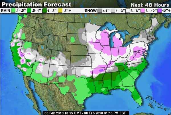
quote:Snow and Ice from Major Storm to Paralyze the Southern Plains
A major storm with heavy snow, debilitating ice, flooding rain and thunderstorms has gotten underway over the southern Plains. The storm threatens to shut down portions of the Interstate 40 corridor as it slides eastward through the mid-South through the end of the week. The storm will then affect part of the mid-Atlantic coast early this weekend. Millions will be impacted by the travel stopping and power robbing storm in the days ahead.

[ Bericht 7% gewijzigd door #ANONIEM op 28-01-2010 20:01:11 ]
WASHINGTON - In het noordoosten van de Verenigde Staten worden honderden vluchten afgelast wegens het dreigende noodweer.
Grote delen van de regio maken zich op voor wat voor een uitzonderlijke sneeuwstorm wordt gehouden.
De sneeuw zou zaterdag toeslaan in onder meer Washington D.C., Maryland en New Jersey.
Gevreesd wordt dat de sneeuwstorm de hevigste wordt sinds 1922 en dat die de streek inclusief de hoofdstad Washington onder een halve meter sneeuw bedekt.
Tweehonderd vluchten
De luchtvaartmaatschappij Delta Air Lines heeft al aangekondigd zaterdag niet in de regio van Washington te vliegen. Zeker tweehonderd vluchten gaan zo niet door.
American Airlines heeft alvast 148 vluchten geschrapt en Southwest alle vluchten naar Washington, Philadelphia en Baltimore van vrijdagavond tot zondagmiddag. Lokale maatschappijen hebben vrijdag aangekondigd dat honderden vluchten zaterdag niet door kunnen gaan.
nu.nl
Het openbare leven in het oosten van de VS ligt grotendeels stil vanwege een zware sneeuwstorm. Vooral West Virginia, Virginia en Washington DC zijn zwaar getroffen. Er wordt voor de komende dag 60 centimeter sneeuw verwacht en de wind is stormachtig.
Veel scholen, overheidsinstellingen en bedrijven zijn eerder dichtgegaan om mensen de kans te geven thuis te komen. In veel supermarkten was geen brood of melk meer te krijgen, en ook zaklampen en sneeuwschuivers raakten uitverkocht.
Er is veel overlast voor het verkeer. Op de weg zijn talloze ongelukken gebeurd en het vliegverkeer ligt deels plat.
NOS
quote:A punishing winter storm will continue to blast an area from the eastern Ohio Valley to the Mid-Atlantic coast today.
The focus for the heaviest snow today will continue to be near and along the Mid-Atlantic coast. Heavy snow will stretch from eastern Pennsylvania to southern New Jersey through the Delmarva Peninsula into the early afternoon hours.
An additional six to as much as twelve inches of snow will fall today bringing snow totals in this region up to the eighteen to twenty-four inch range with locally higher amounts possible.
Look for several more inches of snow to fall across eastern parts of Ohio, West Virginia and southwestern Pennsylvania today which will bring storm totals to over one foot in many locations.
As the low pushes off the coast it will continue to rapidly strengthen which will result in very strong winds near and along the coast. Gusts in excess of 50 miles per hour will be likely along the coasts from the Tidewater of Virginia north to the Jersey shore.
The strong winds combined with falling snow to produce blizzard conditions from coastal Delaware and New Jersey back to the Baltimore/Washington area.
The winds will also serve up high surf which will lead to beach erosion and areas of costal flooding from Atlantic City southward to the Carolina coast.
The storm system will finally wrap its way out to sea taking most of the precipitation with it by this evening.
Look for the snow to begin to wind down from west to east as the day progresses putting the final touches on a storm that in the end will be one for the record books.
All across the north and eastern seaboard areas of the U.S, a mass snow storm has struck. In my hometown we have close to 23 inches and still falling. This is in an area where snow is the norm, but we hardly ever get over 3 inches in one snowfall. Everything is shut down, airports, even hospitals, power in a lot of places. Washington D.C. is buried under snow. For us though, this just seems a good bit of fun(except for the grumpy people). I haven't seen anything like this since 1993. Its good that it happened last night, so we don't have to worry about getting to work. There will be no going anywhere today and maybe not tommorow. I think it is indeed a very cool very unusual event.
Washington, 6 febr. Weerdeskundigen hebben de inwoners van de Amerikaanse hoofdstad Washington opgeroepen vandaag thuis te blijven. Zij voorspellen dat de ,,extreem gevaarlijke'' sneeuwstorm die sinds zaterdagochtend (Nederlandse tijd) door de stad raast, het verkeer ,,riskant en levensbedreigend'' maakt.
De luchthavens van Washington zijn gesloten en de metro rijdt alleen onder de grond. De busdienst is helemaal geschrapt. Ook is er slechts beperkt treinverkeer tussen New York en Washington. Sommige musea en de dierentuin zijn gesloten. Meer dan 120.000 huizen in de hoofdstad en omgeving zitten zonder stroom. De staten Virginia en Maryland en het District of Columbia hebben sneeuwalarm afgekondigd, waardoor de autoriteiten extra volmachten krijgen om het hoofd te bieden aan het noodweer en de nasleep ervan.
Om 06.00 uur 's ochtends lokale tijd lag er al een pak sneeuw van 53 centimeter in Washington. De meteorologen voorspellen dat in de hoofdstad tot vanavond, als de storm is weggetrokken, 76 centimeter sneeuw kan vallen. Daarmee zou het record van de Grote Knickerbocker Storm van januari 1922 met ongeveer 4 centimeter worden verbroken. De hevige wind van die dag kreeg die naam, omdat toen het Knickerbocker Theater instortte, waardoor bijna honderd mensen omkwamen.
De sneeuwstorm zal niet alleen Washington, Virginia en Maryland treffen, maar ook staten als Indiana en Pennsylvania en delen van de staat New York. Het is overigens uitzonderlijk dat in zo korte tijd zo veel sneeuw in Washington valt. Volgens gegevens van het Amerikaanse KNMI is het sinds 1870 slechts dertien keer voorgekomen dat er meer dan 30 centimeter sneeuw viel. Zes weken geleden was dat voor het laatst. Toen viel tijdens een sneeuwstorm 41 centimeter.
quote:Veel bovengrondse draden h�.Op zaterdag 6 februari 2010 15:14 schreef Glijdt_licht het volgende:
Valt me op dat in de USA altijd de stroom uitvalt.
quote:Op bepaalde punten lopen ze voorop, maar zuinige auto's maken als de Japanners kunnen ze b.v. niet. De V.S. is nogal overgewaardeerd op het gebeid van technologie.Op zaterdag 6 februari 2010 16:18 schreef FP128 het volgende:
Ja en mag je mij nu eens uitleggen waarom een land als de Verenigde Staten die over het algemeen bekend staan om hun technologie...
quote:Tja, bovengronds zal wel eenvoudiger zijn en ook dus goedkoper. Gezien de enorme afstanden van dat land zullen de kosten van ondergronds wel opwegen tegen eventuele schade aan eenvoudig te plaatsen bovengrondse leidingen/dradenOp zaterdag 6 februari 2010 16:18 schreef FP128 het volgende:
Ja en mag je mij nu eens uitleggen waarom een land als de Verenigde Staten die over het algemeen bekend staan om hun technologie niet zoals wij in Nederland hun netwerk ondergronds aanleggen zodat het op langer termijn allemaal wat minder onderhevig is aan het weer. Dat rijmt toch niet deze (bovengrondse) electriciteitspalen van hout boven de grond waardoor elke keer als er ook maar iets gebeurd met het weer,men te maken heeft met allerlei negatieve gevolgen.
Maar goed, flinke babyboom dus over 9 maand
quote:Geldt voor heel veel landen. In bv Frankrijk is het ook altijd raak. Bij een storm afgelopen winter woei er een boom bij mijn schoonouders om, en die viel over de stroomdraad van de buren. Resultaat: buren drie dagen geen stroom! En dat vindt men normaal. Tenminste in dat dorp.
Wel eens gevraagd waarom het niet ondergronds ligt. Antwoord: He: denk je dat Frankrijk net zoveel geld heeft als Nederland om zoiets te doen, jullie zij hartstikke rijk

quote:Geografie en geld.Op zaterdag 6 februari 2010 16:18 schreef FP128 het volgende:
Ja en mag je mij nu eens uitleggen waarom een land als de Verenigde Staten die over het algemeen bekend staan om hun technologie niet zoals wij in Nederland hun netwerk ondergronds aanleggen zodat het op langer termijn allemaal wat minder onderhevig is aan het weer. Dat rijmt toch niet deze (bovengrondse) electriciteitspalen van hout boven de grond waardoor elke keer als er ook maar iets gebeurd met het weer,men te maken heeft met allerlei negatieve gevolgen.
quote:Slechts dertien keer in 140 jaar tijd, waarvan nu twee keer in zes weken tijdStroomuitval en doden door sneeuwstorm Washington
AMSTERDAM – Een hevige sneeuwstorm trekt vrijdagnacht en zaterdag (lokale tijd) over de Verenigde Staten. Meteorologen in Washington spreken van misschien wel de ergste storm in negentig jaar. Tot nu toe zijn er twee doden gevallen en zitten er in Washington 210.000 mensen zonder stroom.
Dat meldt persbureau Reuters.
Voor Virginia tot in het zuiden van New Jersey wordt in totaal zo’n 50 tot 75 centimeter sneeuw voorspeld.
In Washington viel sinds vrijdagnacht (lokale tijd) al ruim 70 centimeter sneeuw. Het nationale weer instituut heeft inmiddels een 24 uur durende waarschuwing afgegeven voor de regio. President Obama bestempelde de storm als 'snowmaggedon!'
Doden
Naast de hevige sneeuwval stak er zaterdag ook een behoorlijke wind op, tot zo’n 65 kilometer per uur. In de staat Virginia zijn volgens de politie twee doden gevallen. De slachtoffers probeerden een gestrande reiziger te helpen en werden vervolgens overreden door een vrachtwagen. Automobilisten wordt gevraagd niet de weg op te gaan.
Het vliegverkeer in de regio ligt bijna helemaal plat. Op Dulles Airport, net buiten Washington stortte een deel van het dak van een hangar in onder het gewicht van de sneeuw. Niemand raakte gewond.
Stroomuitval
Ook het openbaar vervoer in Washington is tevens ernstig ontregeld. Alleen de ondergrondse metro’s konden nog rijden. Al het busvervoer is gestaakt. Ook veel treinen rijden niet. In totaal zitten meer dan 210.000 mensen zonder stroom, meldt de Amerikaanse krant the Washington Post.
De gouverneur van de Amerikaanse staat Maryland spreekt van de 'ergste sneeuwval die de staat ooit gezien heeft'. Hij speculeert ook over een eventuele afsluiting van alle openbare wegen. "Die optie is er altijd nog", aldus gouverneur O'Malley.
Vooralsnog wordt er geprobeerd op elke snelweg in ieder geval ��n baan open te houden. Dat dit niet altijd kan, is het gevolg van sneeuwophoping. Door de grote hoeveelheid sneeuw ontstaan er heuvels langs de weg waardoor de overige sneeuw soms niet opzij geschoven kan worden.
Uitzonderlijk
Het is overigens uitzonderlijk dat in zo korte tijd zo veel sneeuw in Washington valt. Volgens gegevens van het Amerikaanse KNMI is het sinds 1870 slechts dertien keer voorgekomen dat er meer dan 30 centimeter sneeuw viel. Zes weken geleden was dat voor het laatst. Toen viel tijdens een sneeuwstorm 41 centimeter.

quote:
quote:Dinsdag nog meer sneeuwSneeuwstorm sluit Washington dagen af
AMSTERDAM – Een groot deel van het oosten van de Verenigde Staten wordt geteisterd door zeer zware sneeuwval die vaak gepaard gaat met hevige wind. Vooral de federale hoofdstad Washington DC en de staten Virginia en Maryland zijn getroffen.
Dat meldt persbureau Reuters.
Meteorologen in Washington spreken van misschien wel de ergste storm in negentig jaar. Tot nu toe zijn er twee doden gevallen en rond het middaguur zaten er in Washington 210.000 mensen zonder stroom.
Het duurt volgens The Washington Post nog dagen voordat alle wegen weer goed bereikbaar en sneeuw vrij zijn. Dinsdag wordt nieuwe sneeuwval verwacht.
In de stad Washington viel sinds vrijdagnacht (lokale tijd) al ruim 70 centimeter sneeuw. Het nationale weer instituut heeft inmiddels een 24 uur durende waarschuwing afgegeven voor de regio. President Obama bestempelde de storm als "snowmageddon!"
Opruimen
Joan Morris, hoofd transport van de staat Virginia: “Maandag wordt geen dag om naar het werk te gaan. Het zal nog tot halverwege de week duren voor we de binnenwegen vrij hebben gemaakt.”
“In het geval van nieuwe sneeuw op dinsdag zal het opruimen nog langer duren. We hebben dan alles nodig voor de snelwegen."
Doden
Naast de hevige sneeuwval stak er zaterdag ook een behoorlijke wind op, tot zo’n 65 kilometer per uur. In de staat Virginia zijn volgens de politie twee doden gevallen. De slachtoffers probeerden een gestrande reiziger te helpen en werden vervolgens overreden door een tractor. Inwoners van Washington DC wordt opgeroepen vooral niet naar buiten te gaan.
Het vliegverkeer in de regio ligt bijna helemaal plat. Op Dulles Airport, net buiten Washington stortte een deel van het dak van een hangar in onder het gewicht van de sneeuw. Niemand raakte gewond. In verschillende staten is een sneeuwalarm afgekondigd.
Stroomuitval
Ook het openbaar vervoer in Washington is tevens ernstig ontregeld. Alleen de ondergrondse metro’s konden nog rijden. Al het busvervoer is gestaakt. Ook veel treinen rijden niet. In totaal zaten rond het middaguur meer dan 210.000 mensen zonder stroom, meldt de Amerikaanse krant the Washington Post.
De gouverneur van de Amerikaanse staat Maryland spreekt van de 'ergste sneeuwval die de staat ooit gezien heeft'. Hij speculeert ook over een eventuele afsluiting van alle openbare wegen. "Die optie is er altijd nog", aldus gouverneur O'Malley.
Vooralsnog wordt er geprobeerd op elke snelweg in ieder geval ��n baan open te houden. Dat dit niet altijd kan, is het gevolg van sneeuwophoping. Door de grote hoeveelheid sneeuw ontstaan er heuvels langs de weg waardoor de overige sneeuw soms niet opzij geschoven kan worden.
Uitzonderlijk
Het is overigens uitzonderlijk dat in zo korte tijd zo veel sneeuw in Washington valt. Volgens gegevens van het Amerikaanse KNMI is het sinds 1870 slechts dertien keer voorgekomen dat er meer dan 30 centimeter sneeuw viel. Zes weken geleden was dat voor het laatst. Toen viel tijdens een sneeuwstorm 41 centimeter.
Adrian Fenty, burgemeester van de Amerikaanse hoofdstad, vertelt in een video ondanks de slechte vooruitzichten alles op alles te zetten om de stad maandag weer klaar te hebben voor het normale leven.


die auto


quote:Meer sneeuw voor regio Washington
Weermannen en -vrouwen in het noordoosten van de Verenigde Staten verwachten dinsdagavond en woensdag nog meer sneeuw in de regio van de Amerikaanse hoofdstad Washington. De burelen van de Amerikaanse federale regering blijven er maandag dicht als gevolg van de uitzonderlijk zware sneeuwstorm van het afgelopen weekeinde. In Washington viel een record pak sneeuw van ruim 80 centimeter.
Grote sneeuwstorm in Washington
In de hele regio wordt druk sneeuw geruimd, berichtte The Washington Post maandag. Er is nauwelijks openbaar vervoer. Vrijwel alle scholen zijn dicht. De metro rijdt volgens een beperkt schema en enkel in het ondergrondse netwerk van de Amerikaanse hoofdstad. Bovengronds is er nog geen beginnen aan. Talrijke treinstellen zijn bovendien ingesneeuwd en moeten eerst worden 'opgegraven' voor ze kunnen worden ingezet.

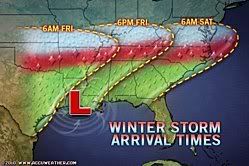
quote:Two storm systems combine to bring a sprawling snowstorm to the Midwest, Mid-Atlantic, and Northeast Tuesday and Wednesday.
The northern storm swirls southeastward from the upper Mississippi Valley today to the lower Ohio Valley Tuesday. Light to occasionally moderate snow moves along with the storm dropping 4 to 8 inches of snow from eastern South Dakota through southern Minnesota and central Iowa.
The southern storm brought a quick 2 to 6 inches of snow across central Arkansas and western Tennessee this morning. Memphis had 3 to 5 inches across the city and Little Rock picked up a quick 1 to 4 inches. Light snow was reported as far east as south-central Tennessee and northern Alabama.
That system dries up as it continues to move eastward this afternoon, but a new round of snow is blossoming to the west over southern Kansas and northern Oklahoma.
The snow lifts to the northeast through northern Arkansas and southern Missouri on its way to the lower Ohio Valley by this evening. Accumulations of 2 to 6 inches are possible across southern Kansas and northern Oklahoma. Additional snowfall of 3 to 9 inches is possible across southern Missouri and northern Arkansas through Tuesday morning.
Tuesday the storms combine to bring a snowstorm to the Midwest, Great Lakes, and Ohio Valley.
Significant accumulations of 6 inches or more are likely in an area bound by Chicago, Indianapolis, Columbus, Ohio, Cleveland, and Detroit.
Tuesday afternoon and evening the storm begins moving into the Mid-Atlantic spreading snow into western and northern Virginia during the afternoon and into the southern half of eastern Pennsylvania, Delaware, Maryland, and New Jersey during the evening.
Overnight the snow spreads throughout the rest of eastern Pennsylvania into New York and southern New England.
On Wednesday the storm rapidly strengthens off the New Jersey/Long Island coastline prolonging heavy snow from Washington to Boston. Strong winds develop Tuesday night and Wednesday producing blizzard conditions along the coast.
quote:A ferocious blizzard likely to be even more intense that last weekend's crippling Mid-Atlantic "Snowmageddon" snowstorm is rapidly intensifying off the Northeast U.S. coast, just south of New York City today. Blizzard conditions with heavy snow, high winds, and near zero visibility have hit or are expected to hit portions of West Virginia, Virginia, Maryland, Washington D.C., Pennsylvania, Delaware, New Jersey, and New York, including the cities of New York, Newark, Wilmington, Atlantic City, Philadelphia, Baltimore, and Washington D.C. The storm responsible tracked across the center of the country yesterday, leaving a wide swath of snow amounts of 4 - 16" across Texas, Tennessee, South Dakota, Oklahoma, Mississippi, Missouri, Minnesota, Kansas, Iowa, Arkansas, Alabama, Wisconsin, Illinois, Michigan, Ohio, Indiana, and Kentucky. The storm is now centered over Lake Erie, with a new 989 mb low pressure center developing off the coast of Delaware. This new low is predicted to "bomb" into a mighty Nor'easter with a central pressure below 970 mb, the kind of pressure typically found in a Category 1 hurricane. This will bring strong winds, gusting over 40 mph, to a large portion of the Mid-Atlantic and Northeast U.S. today, causing a larger region of blizzard conditions with blowing and drifting snow than was experienced during last weekend's "Snowmageddon" Nor'easter. Fortunately, today's Nor'easter will be far enough from the coast during its peak intensity that coastal flooding from storm surges will not be a concern. In addition, today's blizzard has a lower moisture content than "Snowmageddon", and the snowfall totals will not be as great. The storm has also wrapped in some warmer air from the south, resulting in a change-over to freezing rain and sleet near the coast this morning, which will limit accumulations. Nevertheless, most of the Mid-Atlantic that received two feet of snow from "Snowmageddon" last weekend will receive another foot of snow today, and there is a significant risk of roof collapses from the weight of all this snow.

Wat zijn de vooruitzichten trouwens? Wat is een betrouwbare site om dat in de gaten te kunnen houden?
[ Bericht 23% gewijzigd door Bulletdodger op 11-02-2010 10:06:46 ]
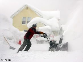
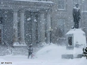
WASHINGTON (ANP) - Het noordoosten van de Verenigde Staten heeft te kampen met winters noodweer. Washington DC gaat dit seizoen gebukt onder de hevigste sneeuwval ooit, die donderdag 139,4 centimeter bereikte.
Circa zesduizend vluchten tussen Washington en New York werden geannuleerd, waardoor tienduizenden reizigers strandden. De ambtenaren in de Amerikaanse hoofdstad kregen voor de vierde dag op een rij sneeuwvrij, wat ruwweg 100 miljoen dollar (73 miljoen euro) per dag kost wegens verloren productiviteit, aldus Amerikaanse media.
Het openbaar vervoer in de miljoenenstad ligt plat en de autoriteiten adviseren iedereen thuis te blijven.
Elsevier
quote:Big snow for the Deep South
Under beautiful clear blue skies, the Northeast blizzard is over. Unfortunately, the second big dig out in less than a week is underway.
From Atlantic City and Philadelphia to Baltimore and Washington, this winter is now their snowiest ever and more snow could be on the way Monday.
Also from north Jersey and the New York City metro area to southeast Massachusetts, more of the Northeast felt the punch of this second major snowstorm.
Meanwhile, the Deep South now has its own snowstorm.
As of midday, snow already reached 6 inches in and around the Dallas-Fort Worth area. Parts of north-central Texas could approach 1-foot accumulations before the snow ends overnight.
Snow is heading eastward along the I-20 corridor. Shreveport, Louisiana and Jackson, Mississippi could pick up accumulations of 3 to 5 inches by Friday morning. A few locations could even near 7 or 8 inches.
Rain changing to snow could produce 1-to-3-inch accumulations all the way to the Gulf Coast in Mobile.
From Birmingham and Montgomery in Alabama eastward across northern and central Georgia including Atlanta and South Carolina including Columbia, 1-to-3-inch snowfall is likely and a few locations could creep into the 4-to-6-inch range.
The storm will exit into the Atlantic by Saturday.
For the latest on the Northeast dig out and the snows developing across the South stay tuned to The Weather Channel and here on weather.com.
quote:Wow, sneeuw in Texas, zullen ze blij mee zijn. Toen ik daar begin december aan het werk was, verscheen de helft al niet op het werk, omdat er natte sneeuw viel bij 5C.Op donderdag 11 februari 2010 19:23 schreef aloa het volgende:
Nu is het zuiden aan de beurt. Van Texas tot aan het noorden van Florida wordt sneeuw verwacht.
[..]
quote:Meer vluchten VS geschrapt dan na 9/11
WASHINGTON - Wegens het barre winterweer zijn in de Verenigde Staten meer vluchten geschrapt dan na de aanslagen van radicale moslims op 11 september 2001 op New York en Washington.
Ongeveer een miljoen passagiers zijn de dupe van de annuleringen, aldus een functionaris van de Amerikaanse luchtvaartautoriteiten tegen de Amerikaanse nieuwszender ABC.
Naar schatting 13.000 vluchten gingen niet door in verband met de weersomstandigheden. Het oosten van de VS gaat gebukt onder een van de witste winters ooit met zware sneeuwstormen. Op veel plaatsen viel de stroom uit en stortten daken in.
tot een veredelde bananenrepubliek is gedevalueerd gezien de hevige sneeuwstormen.
Echt,met zo veel kennis en technologie en dan nog moeten buigen voor de natuur is
en blijft natuurlijk komisch.
In Europa en bijvoorbeeld Azi� en dan met name Japan heeft men dan toch veel meer
knowhow hoe alvast voorbereidingen te treffen voor als er een natuurramp(sneeuw/
regenval of aardbevingen)dreigt. In de VS is dan gelijk het hele maatschappelijk verkeer
verlamt en vliegen de "breakingnews" onderbrekeningen
hebben) je om de oren
quote:Op vrijdag 12 februari 2010 14:08 schreef FP128 het volgende:
Ik blijf het komisch vinden hoe het meest vooruitstrevende land ter wereld in 1 klap
tot een veredelde bananenrepubliek is gedevalueerd gezien de hevige sneeuwstormen.
Echt,met zo veel kennis en technologie en dan nog moeten buigen voor de natuur is
en blijft natuurlijk komisch.
In Europa en bijvoorbeeld Azi� en dan met name Japan heeft men dan toch veel meer
knowhow hoe alvast voorbereidingen te treffen voor als er een natuurramp(sneeuw/
regenval of aardbevingen)dreigt. In de VS is dan gelijk het hele maatschappelijk verkeer
verlamt en vliegen de "breakingnews" onderbrekeningen
hebben) je om de oren
Jij hebt geen idee waar je het over hebt. Het weer in de VS is veel extremer dan Europa. Hier ligt ook alles plat met >50cm sneeuw in de grote steden. Ik denk zelfs dat het hier meer problemen gaat geven, omdat wij nuchtere Nederlands het onzin gaan vinden om wat extra eten en drinken in te slaan.
quote:Media speelt een grote rol natuurlijk.. vooral in amerika. Als er in Japan een halve meter sneeuw valt, dan ligt het dagelijks leven ook plat.Op vrijdag 12 februari 2010 14:08 schreef FP128 het volgende:
Ik blijf het komisch vinden hoe het meest vooruitstrevende land ter wereld in 1 klap
tot een veredelde bananenrepubliek is gedevalueerd gezien de hevige sneeuwstormen.
Echt,met zo veel kennis en technologie en dan nog moeten buigen voor de natuur is
en blijft natuurlijk komisch.
In Europa en bijvoorbeeld Azi� en dan met name Japan heeft men dan toch veel meer
knowhow hoe alvast voorbereidingen te treffen voor als er een natuurramp(sneeuw/
regenval of aardbevingen)dreigt. In de VS is dan gelijk het hele maatschappelijk verkeer
verlamt en vliegen de "breakingnews" onderbrekeningen
hebben) je om de oren
quote:Beetje overtrokken. In China zijn er problemen genoeg. Nederland slaat op hol als er een paar centimeter valt, Belgie idem. En Rome ook al bij drie cmOp vrijdag 12 februari 2010 14:08 schreef FP128 het volgende:
In Europa en bijvoorbeeld Azi� en dan met name Japan heeft men dan toch veel meer
knowhow hoe alvast voorbereidingen te treffen voor als er een natuurramp(sneeuw/
regenval of aardbevingen)dreigt. In de VS is dan gelijk het hele maatschappelijk verkeer
verlamt en vliegen de "breakingnews" onderbrekeningen
hebben) je om de oren
http://www.nu.nl/buitenland/2183176/chaos-in-rome-sneeuw.html
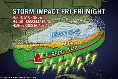
quote:A big storm is spreading heavy, wet snow, dangerous travel, delays, cancellations and power outages across the Deep South into early Saturday. The snow is pushing to the east along the I-10 and I-20 corridors. Even some of the northern shore of the Gulf Coast, a change to a wintry mix or wet snow will follow heavy rain and flooding problems. Falling temperatures during the late afternoon and evening hours could turn some wet roads to ice. In the wake of this storm and the recent northern blizzards, close to 75 percent of the nation could have snow on the ground.

quote:People across the mid-Atlantic will once again be dealing with some snow early next week as a storm pushes through the region. However, the storm is expected to take a track that hugs the coast, which will allow rain to mix with the snow and hold snow amounts down in Washington, D.C., Baltimore, and Philadelphia. Less snow is good news for the buried region, but travel will still become slick and dangerous for a time. This storm will also spread snow into New England, where snow totals will be higher.
quote:Ook Zuiden van de Vs onder sneeuwlaag
Het diepe zuiden van de Verenigde Staten is vrijdag bezocht door een sneeuwstoring die het gebied met een laag sneeuw bedekte, een zeldzaamheid in dit deel van de VS. Sommige plaatsen in het zuiden hadden al meer dan tien jaar geen sneeuw gehad.
Van Texas tot het noorden van Florida en langs de kusten van Georgia en South Carolina viel sneeuw. Dallas maakte de witste winter sinds 32 jaar mee: er viel dertig centimeter sneeuw.
Het sneeuwgebied veroorzaakte ruim tweehonderd verkeersongelukken en zorgde voor stroomstoringen bij duizenden mensen. Honderden vluchten werden geannuleerd.
Hoewel de sneeuwlaag niet zo groot was als in bijvoorbeeld Washington, was het effect minstens zo verlammend. De zuidelijke staten hebben niet het materiaal om de sneeuw te lijf te gaan.
De verwachting van 2,5 centimeter sneeuw was dan ook voldoende om tientallen scholen in Noord-Florida, Georgia en delen van Alabama te sluiten.
quote:Sneeuwstormen kosten 2 miljard
De sneeuwstormen waarmee het oosten van de Verenigde Staten sinds een week te kampen heeft, hebben 2 miljard dollar schade veroorzaakt.
Dat blijkt uit een studie van het bedrijf Eqecat, dat gespecialiseerd is in het opmaken van risicomodellen. Het softwarebedrijf Citrix schat dat deze winter bijna 50 miljoen werkuren verloren gingen doordat mensen niet op hun werk geraakten.
Het grootste deel van de schade werd aan de oostkust tussen Virginia en de streek van New York aangericht, dus ook in Washington, Baltimore en Philadelphia. Meestal gaat het om schade aan daken en dakgoten en om breuken in leidingen, waardoor lekken in de gebouwen ontstaan.
Nog nooit werd zoveel sneeuw opgetekend aan de oostkust, met onder meer ruim twee meter sneeuw op de luchthaven van Baltimore.
Ook in de Verenigde Staten blijft de winter ijskoud. Zelfs in de anders zo zonnige staat Florida is het al weken koud. Veel wilde dieren hebben te lijden onder de kou en worden zelfs dood aangetroffen op straat.
Op sommige plaatsen in Florida viel het voorbije weekend al voor de tweede keer dit seizoen sneeuw. Dat zijn veel ingeweken dieren, zoals leguanen en pythons, niet gewend. De dieren vriezen dood in een boom en vallen vervolgens op de grond. Volgens dierenspecialisten zou mogelijk de helft van de populatie leguanen deze winter al gestorven zijn.
Honden
Ook de bewoners van Florida kunnen tegenwoordig al eens een dode leguaan nabij hun huis tegenkomen. Soms doen ze nog een poging om de dieren zelf op te warmen. Ze worden echter gewaarschuwd om hun honden op afstand te houden. De overleden leguanen kunnen immers nog steeds giftig zijn.
Pythons
Er zijn ook al dode pythons aangetroffen. Die dieren kunnen gemakkelijk langer dan twee meter worden en zijn gevaarlijk voor mensen. In de Everglades vormen ze een bedreiging voor de lokale diersoorten en dus zullen ze in Florida veel minder treuren om de dood van deze dieren. Vaak werden ze ingevoerd als huisdier en in het wild losgelaten.
Zeeschildpadden
Helaas zijn ook de lokale dieren van Florida de extreme winter niet gewend. Zo stierven er al tientallen krokodillen en vorige maand werden ongeveer 4.000 zeeschildpadden uit het ijskoude water geplukt. Zij mogen de winter doorbrengen in iets warmere omstandigheden. Zeeschildpadden zijn immers een bedreigde diersoort. (gb)
hln
Vorige week stond in de USA today een artikel dat er in 49 staten sneeuw lag! Dat gebeurt echt haast nooit. De laatste staat was uiteraard Hawaii.
quote:Jan VisserEen actieve depressie van mogelijk historische proporties treft de komende dagen het noordoosten van de Verenigde Staten. Vandaag al teistert een andere depressie het aandachtsgebied met zware sneeuw (tot regionaal meer dan 30 centimeter) en een mix van smeltende sneeuw en regen. De tweede depressie ontwikkelt zich ter hoogte van de zuidoostkust en veroorzaakt de komende dagen in met name de staat New York een ware blizzard. Er worden windsnelheden (uit het noordoosten) tot rond 120 km/uur verwacht en het gaat wederom hard sneeuwen.
In de kustgebieden gaat het hard regenen en door een combinatie van hoge windsnelheden en hoge zee�n, kan het tot kusterosie en overstromingen komen. Steden die met ‘blizzardconditions’ te maken gaan krijgen zijn onder meer New York City, Rochester, Syracuse en Albany. In plaatsen als Boston, Portland en Providence is wateroverlast mogelijk. Er wordt trouwens gesproken over een ‘snow hurricane’ vanwege de combinatie van zware sneeuw en windsnelheden boven 100 km/uur.
quote:daar gaan we weerSchools close: 18 inch of snow expected
Some New Jersey schools have announced they will be closed today due to the impending winter storm, according to the News 12 school closing list.
A number of schools have also scheduled early release time.
The National Weather Service is calling for 4 to 8 inches of snow in south Jersey, 8 to 12 inches in the center part of the state and as much 18 inches in parts of north Jersey before it ends on Friday.
Strong winds could help reduce visibility with blowing snow.
NEW YORK - Honderdduizenden mensen zitten vrijdag zonder stroom in het noordoosten van de Verenigde Staten. Een zware sneeuwstorm heeft weer het openbare leven lamgelegd.
Amerikaanse media meldden dat alle openbare basisscholen in New York City dicht bleven. De stad raakte bedolven onder tientallen centimeters sneeuw.
Sommige snelwegen werden afgesloten omdat ze nauwelijks nog begaanbaar waren. Bomen konden het pak sneeuw niet meer dragen en vielen om. Daardoor werden weer elektriciteitskabels geraakt, die knapten.
Duizenden vluchten werden geannuleerd in het gebied. De storm trekt uiterst langzaam verder en zal nog enkel dagen aanhouden.
nu.nl
quote:The U.S. just experienced its coldest winter in 25 years, according to the National Climatic Data Center. The winter period December - February was the 18th coldest winter in the contiguous U.S. over the past 115 years, and the coldest since 1984 - 1985. It was also a wet winter, ranking 19th wettest. The states experiencing the coldest winters, relative to average, were Texas and Louisiana, which had their 5th coldest winters on record. Mississippi, Georgia, Alabama, Oklahoma, Arkansas, Florida, and South Carolina also had a top-ten coldest winter. The only state much above average was Maine, which had its 3rd warmest winter. As I discussed earlier this week, this winter's cold weather over the U.S. is largely due to the Arctic Oscillation/North Atlantic Oscillation, which assumed its most extreme negative configuration since record keeping began in 1950. El Ni�o helped keep things cool from Texas to the Southeastern U.S., as well.
A cold February in the U.S.
February temperatures were 2.2�F below average across the contiguous U.S., making it the 29th coldest February in the 115-year record. For the second month in a row, Florida was the coldest state, relative to average. Florida had its 4th coldest February on record. Seven other states had February temperatures between 5th and 8th coldest on record: Louisiana, Texas, Alabama, Mississippi, Arkansas, Georgia, and South Carolina. Maine had its 3rd warmest February, New Hampshire its 5th, and Washington its 6th. Precipitation across the U.S. was near average in February.
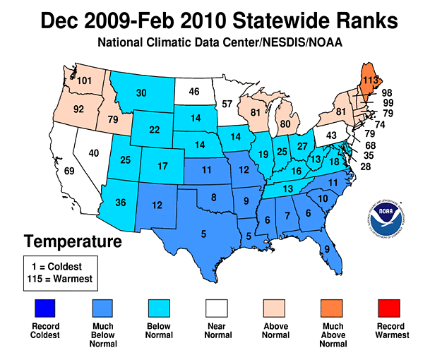

quote:Do not let the current mild weather fool you across the Rockies, Plains and Great Lakes. Winter is not over and the return of disruptive snow is right around the corner.
All places across the nation's midsection will turn noticeably colder at some point this weekend and snow will fall on some areas dealing with flooding or beginning cleanup.
While temperatures were surging into the 50s and 60s throughout the lower elevations of the Rockies, Plains and Great Lakes Wednesday, highs on Saturday, the first day of spring, will be mainly the 30s for much of the region.
As the chilly air plunges southward, a snowstorm will get underway across the central Rockies late on Thursday. The snow will spread into northern New Mexico and the central Plains during Friday.
A period of rain will mark the storm's arrival along the Front Range of the Rockies and central Plains. A changeover to substantial snow will follow.
Gusty northerly winds ushering in the cold will worsen the situation by whipping the snow around and reducing visibility.
The potential exists for 6-12 inches of snow to blanket southeastern and central Wyoming on Thursday night into Friday. This includes Cheyenne.
Around 6 inches is in store for Denver on Friday. Airline passengers should prepare for lengthy delays and potential cancellations. The resultant ripple effect threatens to impact travelers at other airports across the nation.
Travel along Interstates 25, 70, 76, 80 and 90 will become slow and slippery. Parents should plan for possible school closures.
On Friday night into the weekend, many places from the Texas Panhandle to northern Missouri and Iowa to upper Michigan are forecast to receive accumulating snowfall. Amounts will range from 3 to 6 inches, but locally more may fall.
The exact track of the storm and snow totals are not set in stone. The possibility that the snow expands to part of the Midwest. cannot be ruled out.
Residents of Chicago could forced to sweep off their cars after enjoying 60-degree temperatures the next couple of days. Flakes could even fly in St. Louis and Detroit late in the weekend.
While the snow could disrupt travel and daily routines, there is one benefit to the invading cold air. The rate of snow melt will slow across the flood-ravaged northern and central Plains and part of the Midwest.
quote:Late-Season New England Snowstorm Continues
The late-season snowstorm that got underway across northern New England on Tuesday will continue into today, leading to more slick travel and potential power outages.
Before ending by this evening, snow will continue to accumulate from the Adirondack Mountains of northern New York to the higher terrain of Maine.
A fresh 3 to 6 inches of snow will add to what fell prior to daybreak in the highest terrain. Even the valley cities of Plattsburgh, N.Y., and Burlington, Vt., will receive an additional coating to an inch this morning.
Substantial snow amounts have already been measured across northern New England. Through late Tuesday evening, North Underhill, Vt., topped the storm's snowfall totals list with 13.3 inches.
Below are other snowfall totals, as of late Tuesday evening:
--Jericho, Vt.: 12.0 inches
--Cambridge, Vt.: 11.0 inches
--Marshfield, Vt.: 6.0 inches
--Whippleville, N.Y.: 6.0 inches
Burlington, Vt., picked up 2.8 inches of snow on Tuesday. That exceeded the day's previous snowfall record of 1.3 inches from 1946.
As today's snow piles onto the snow that fell on Tuesday, its weight may prove to be too much for tree limbs and power lines in the higher terrain. With temperatures close to freezing, the snow is heavy and wet in nature.
Residents should prepare for possible power outages. Additional damage or bodily harm could result from the falling tree limbs.
Motorists will encounter difficult travel on mountain roadways. Some untreated roads could even be slushy and slippery for this morning's commute in the lower elevations, but the heaviest snow totals here will be measured on grassy and elevated surfaces.