WKN Weer, Klimaat en Natuurrampen
Lees alles over het onstuimige weer op onze planeet, volg orkanen en tornado's, zie hoe vulkanen uitbarsten en hoe Moeder Aarde beeft bij een aardbeving. Alles over de verwoestende kracht van onze planeet en tal van andere natuurverschijnselen.


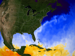
Sea surface temperatures in the Gulf of Mexico rise due to natural summer warming. These warm surface temperatures are a contributing factor to favorable conditions that can lead to the formation of tropical storms and hurricanes in the Gulf of Mexico and off the Eastern Shore of the United States. In general, hurricanes tend to form over warm ocean water whose temperature is 82 degrees Fahreheit (approximately 27.7 degrees Celsius) or higher. These areas are depicted in yellow, orange, and red. This data was taken by the AMSR-E instrument aboard the Aqua satellite.
NASA
NASA

Mooi die staat nu ook in de OP. Want die misten we nog.quote:Op dinsdag 29 mei 2007 22:25 schreef aloa het volgende:
Sea surface temperatures in the Gulf of Mexico rise due to natural summer warming. These warm surface temperatures are a contributing factor to favorable conditions that can lead to the formation of tropical storms and hurricanes in the Gulf of Mexico and off the Eastern Shore of the United States. In general, hurricanes tend to form over warm ocean water whose temperature is 82 degrees Fahreheit (approximately 27.7 degrees Celsius) or higher. These areas are depicted in yellow, orange, and red. This data was taken by the AMSR-E instrument aboard the Aqua satellite.
[afbeelding]
NASA
quote:Op dinsdag 29 mei 2007 22:36 schreef Drugshond het volgende:
[..]
Mooi die staat nu ook in de OP. Want die misten we nog.
Tropische depressie 2-E (Barbara)
Op 28 mei ontwikkelde zich een lagedrukgebied boven het zuidwesten van de Golf van Tehuantepec. Aanvankelijk dreef het lagedrukgebied noordwaarts en onder gunstige omstandigheden; het warme zeewater van 30C en divergerende luchtstromingen op grote hoogte, ontwikkelde het lagedrukgebied zich op 29 mei tot tropische depressie 2-E op ongeveer 380km ten zuid-zuidoosten van Acapulco de Juarez.
Die kan weleens voor flink wat overlast gaan zorgen

[ Bericht 1% gewijzigd door #ANONIEM op 30-05-2007 06:12:21 ]

Dat kan wel eens een vervelende dame worden idd....quote:Op woensdag 30 mei 2007 06:11 schreef aloa het volgende:
[..]
Tropische depressie 2-E (Barbara)
Op 28 mei ontwikkelde zich een lagedrukgebied boven het zuidwesten van de Golf van Tehuantepec. Aanvankelijk dreef het lagedrukgebied noordwaarts en onder gunstige omstandigheden; het warme zeewater van 30C en divergerende luchtstromingen op grote hoogte, ontwikkelde het lagedrukgebied zich op 29 mei tot tropische depressie 2-E op ongeveer 380km ten zuid-zuidoosten van Acapulco de Juarez.
Die kan weleens voor flink wat overlast gaan zorgen
[afbeelding]
tvp'tje
[b]Op maandag 6 september 2010 00:28 schreef tong80 het volgende:[/b]
GVD Wat moet jij een trotse vader zijn :)
:P
GVD Wat moet jij een trotse vader zijn :)
:P
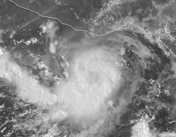
Tropical Storm Barbara Forms: An Unusually Active Start to the Eastern Pacific Hurricane Season
Forming just days after the first storm of the season, newly developed tropical storm Barbara is looming over warm ocean waters off Mexico's Pacific coast. Only twice before - in 1956 and 1984 - have there been two eastern Pacific named storms in the month of May. At 11:00 a.m. EDT (1500 UTC) on Wed., May 30, Barbara was located near 14.2 degrees north latitude and 97.3 degrees west longitude, or about 125 miles south-southwest of Puerto Angel, Mexico. Storm movement was nearly stationary, with maximum sustained winds near 35 knots (40 mph), and gusts to 45 knots (52 mph). Minimum central air pressure was estimated at 1006 millibars.
Satellite imagery shows Barbara has become a bit stronger and better organized. An upper-level trough (broad, extended area of low pressure) is developing over Mexico and the western Gulf of Mexico, while an upper-level ridge (broad, extended area of high pressure) is in place over the Pacific, west of the trough. Forecasters expect these conditions to force Barbara on a southward drift away from Mexican coastline for the next day or two. After that, the storm track becomes highly uncertain, although a continued westward path is most likely.
Atmospheric conditions remain generally favorable for additional strengthening and some forecast models bring the storm to hurricane strength by Fri., Jun. 1, as it travels over very warm ocean waters.
This visible satellite image of tropical storm Barbara was taken at 10:45 a.m. EDT (1445 UTC) on Wed., May 30, from the Geostationary Operational Environmental Satellites (GOES). The deepest clouds (bumpy white) are likely associated with thunderstorms, clustered near the storm center and west of its main circulation. Image credit: NOAA. Storm summary: Mike Bettwy, RSIS/Goddard Space Flight Center

Global warming: Tropical storms revealed as new factor in heat mix
Bron : Yahoo.news
Wed May 30, 1:40 PM ET
PARIS (AFP) - Hurricanes and typhoons play a significant role in distributing the ocean's heat, say US researchers, who believe they have uncovered a major, but hitherto-ignored aspect of global warming.
Driven by mighty circular winds, cyclones in the western Atlantic, western Pacific and Indian Ocean have long been known to whip up the sea and leave its local surface areas cooler than before.
In a paper appearing on Thursday in Nature, the weekly British science journal, Matthew Huber and Ryan Sriver of Purdue University in Indiana make the first stab at calculating how and where this displaced heat, driven from the surface by the cyclone, ends up.
Their computer model factors in surface sea temperatures before and after a storm's passage, as well as ocean depth and currents.
They found that a cyclone acts rather like the spinning steel blades of a food mixer as it is lowered into a bowl of batter.
The whirling winds so churn the sea that the surface heat is distributed down vertically, towards the depths of the local ocean area, but also circulating it towards the poles.
As much as a seventh of heat transported by the oceans could be linked to cyclones, the paper says.
The finding is important, because future climate change depends to a very high degree on the oceans, which cover two-thirds of the planet's surface and soak up massive amounts of heat from the atmosphere.
The role of cyclones has been overlooked until now, Huber and Sriver believe, because computer models of the world's climate systems only factor in sustained winds that last longer than five days, which would leave out most storms.
Further investigation into cyclone mixing is needed, they say.
If cyclones become more frequent as a result of higher sea temperatures, this in turn will step up the distribution of warm waters to higher latitudes, they warn.
That, in turn, would have plenty of potential for knock-on effects to the climate system.
"Cyclone-induced mixing is a fundamental physical mechanism that may act to stabilise tropical temperatures, mix the upper ocean and cause polar amplification of climate change," the researchers say.
[/q]
Bron : Yahoo.news
Wed May 30, 1:40 PM ET
PARIS (AFP) - Hurricanes and typhoons play a significant role in distributing the ocean's heat, say US researchers, who believe they have uncovered a major, but hitherto-ignored aspect of global warming.

Driven by mighty circular winds, cyclones in the western Atlantic, western Pacific and Indian Ocean have long been known to whip up the sea and leave its local surface areas cooler than before.
In a paper appearing on Thursday in Nature, the weekly British science journal, Matthew Huber and Ryan Sriver of Purdue University in Indiana make the first stab at calculating how and where this displaced heat, driven from the surface by the cyclone, ends up.
Their computer model factors in surface sea temperatures before and after a storm's passage, as well as ocean depth and currents.
They found that a cyclone acts rather like the spinning steel blades of a food mixer as it is lowered into a bowl of batter.
The whirling winds so churn the sea that the surface heat is distributed down vertically, towards the depths of the local ocean area, but also circulating it towards the poles.
As much as a seventh of heat transported by the oceans could be linked to cyclones, the paper says.
The finding is important, because future climate change depends to a very high degree on the oceans, which cover two-thirds of the planet's surface and soak up massive amounts of heat from the atmosphere.
The role of cyclones has been overlooked until now, Huber and Sriver believe, because computer models of the world's climate systems only factor in sustained winds that last longer than five days, which would leave out most storms.
Further investigation into cyclone mixing is needed, they say.
If cyclones become more frequent as a result of higher sea temperatures, this in turn will step up the distribution of warm waters to higher latitudes, they warn.
That, in turn, would have plenty of potential for knock-on effects to the climate system.
"Cyclone-induced mixing is a fundamental physical mechanism that may act to stabilise tropical temperatures, mix the upper ocean and cause polar amplification of climate change," the researchers say.
[/q]
Tropical Storm Barbara formed Wednesday off the southwestern coast of Mexico and could strengthen to a hurricane over the next several days, the U.S. National Hurricane Center said.
The storm was 118 miles south-southwest of the fishing village of Puerto Angel in southern Oaxaca state and nearly stationary with maximum sustained winds of 40 mph.
It was unclear whether Barbara would turn toward land or head out to open sea after strengthening, but people living along the western coasts of Mexico and Guatemala should monitor the storm in any case, the hurricane center said.
Barbara follows Alvin, the first tropical storm of the eastern Pacific's 2007 season. It formed Monday but was downgraded Tuesday to a tropical depression as it headed away from land. Two eastern Pacific storms in May is unprecedented — the hurricane center has named only two May storms in the past, in 1984 and 1956. (FOX)
Interessante theorie, en klinkt op zich best redelijk. Ik geloof alleen nog niet zo heel erg in modellen zolang ze nog geen flauw idee hebben van de mechanismes achter een orkaan. Zeker die 1/7de lijkt me ook onwaarschijnlijk veel, zeker als het (zoals gesuggereerd) vanaf de tropen helemaal naar de polen moet komen.quote:Op donderdag 31 mei 2007 11:36 schreef Drugshond het volgende:
Global warming: Tropical storms revealed as new factor in heat mix
Ongeveer 5,5 km/uurquote:Op donderdag 31 mei 2007 10:40 schreef Drugshond het volgende:
Er zit in iedergeval niet veel beweging in.
[afbeelding]
Dat gaat inderdaad niet snel
Hurricane Forecast for 2007: 17 Major Storms, 9 Hurricanes, 5 of Them Intense (Foxnews)
FORT COLLINS, Colo. — With the official start of the 2007 hurricane season only hours away, the bad news is that researchers backed up their prediction Thursday that nine hurricanes will form in Atlantic this season, and that five of them could be major.
The good news?
There's only a 50-50 chance that one will hit the east or gulf coasts.
That's the morning line according to researcher William Gray, who released his newest forecast showing an expectation for 17 named storms and nine hurricanes, five of them intense.
The hurricane season runs from June 1 to November 30.
Gray, based at Colorado State University, described it as a very active season. He said there was a 74 percent chance of a major hurricane making landfall somewhere on the U.S. coast.
There is a 50 percent chance of a major hurricane making landfall on the East Coast, including the Florida Peninsula, according to the new forecast; the long-term average is 31 percent.
The chance of a major hurricane hitting the Gulf Coast between the Florida Panhandle and Brownsville, Texas, is 49 percent; the long-term average is 30 percent. There is also an above-average chance of a major hurricane making landfall in the Caribbean, according to the forecast.
Thursday's forecast was largely unchanged from Gray's last forecast, released in early April.
"We expect an above-average hurricane season," said Phil Klotzbach, a member of Gray's team and lead author of the forecast.
The Atlantic hurricane season averages 9.6 named storms, 5.9 hurricanes and 2.3 intense hurricanes per year.
There were 10 named Atlantic storms last year and five hurricanes, two of them major. None of the hurricanes hit the U.S. Atlantic coast.
The devastating 2005 season set a record with 28 named storms, 15 of them hurricanes. Four hurricanes hit the U.S. coast, the worst among them , which devastated parts of the Gulf Coast.

Tropical Storm Barbara
Tropical Storm Barbara, the second named storm of the 2007 Pacific hurricane season, was swirling off the coast of Mexico on May 29, 2007, when it was observed by NASA’s QuikSCAT satellite at 5:25 p.m. local time (00:25 UTC on May 30, 2007). According to Mexico’s National Meteorological Service (Spanish language site), Barbara had sustained winds that peaked around 100 kilometers/hour (55 mph) on May 29, but had eased off since then. The U.S. National Hurricane Center predicted (as of May 31) that the storm most likely would not become a hurricane, but could bring heavy rain to the Mexican and Guatemalan Pacific coastal regions.
This data visualization of QuikSCAT’s observations shows Tropical Storm Barbara and its spiral pattern of winds. The image depicts wind speed in color and wind direction with small barbs. White barbs point to areas of heavy rain. The storm does not have a clear, rain-free center or a tight spiral shape as would be expected of a larger and more powerful storm.
QuikSCAT employs a scatterometer, which sends pulses of microwave energy through the atmosphere to the ocean surface, and measures the energy that bounces back from the wind-roughened surface. The energy of the microwave pulses changes depending on wind speed and direction, giving scientists a way to monitor wind around the world. This technique does not work over land, but allows measurements in storms over oceans.
The Pacific hurricane season begins on May 15 each year, and in 2007, the season had already registered two named storms by the end of the month, Alvin and Barbara. The U.S. National Hurricane Center has only twice before recorded more than one named storm in the Pacific in May (in 1984 and 1956). Hurricane forecasters have been predicting a busy season for hurricanes in both the Pacific and Atlantic basins in 2007, and the early surge of storms is consistent with this forecast.

A TROPICAL STORM WARNING HAS BEEN ISSUED
FOR THE WEST COAST OF FLORIDA FROM BONITA BEACH NORTHWARD TO KEATON
BEACH...AND A TROPICAL STORM WATCH HAS BEEN ISSUED FROM NORTH OF
KEATON BEACH TO ST. MARKS.
FOR THE WEST COAST OF FLORIDA FROM BONITA BEACH NORTHWARD TO KEATON
BEACH...AND A TROPICAL STORM WATCH HAS BEEN ISSUED FROM NORTH OF
KEATON BEACH TO ST. MARKS.
/ ¦ ¦ / ¦ ¦
welk systeem zorgt hiervoor, kan zo snel even niets vindenquote:Op vrijdag 1 juni 2007 22:41 schreef highway101 het volgende:
A TROPICAL STORM WARNING HAS BEEN ISSUED
FOR THE WEST COAST OF FLORIDA FROM BONITA BEACH NORTHWARD TO KEATON
BEACH...AND A TROPICAL STORM WATCH HAS BEEN ISSUED FROM NORTH OF
KEATON BEACH TO ST. MARKS.
[b]Op maandag 6 september 2010 00:28 schreef tong80 het volgende:[/b]
GVD Wat moet jij een trotse vader zijn :)
:P
GVD Wat moet jij een trotse vader zijn :)
:P


Wat een welopgevoede jongen! Netjes jezelf op 1 juni aanmelden, en nog keurig midden op de dag. Goed hoor.
Wel grappig dat de eerste twee stormen van het jaar op plekken lijken te ontstaan die volgens de NASA nog niet of nauwelijks warm genoeg zijn. En als ik zie hoe Barry aan het doorscheuren is, zal het met de shear toch ook niet meevallen.
Wel grappig dat de eerste twee stormen van het jaar op plekken lijken te ontstaan die volgens de NASA nog niet of nauwelijks warm genoeg zijn. En als ik zie hoe Barry aan het doorscheuren is, zal het met de shear toch ook niet meevallen.
Florida is er in elk geval 'blij' mee... ivm de aanhoudende droogte..
===============================================
Tropical Storm Barry Targets Northern Florida (fox)
MIAMI — Tropical Storm Barry brought heavy rain to a parched Florida early Saturday, along with strong winds and heavy surf along the state's Gulf coast.
Rain was falling throughout the state, where droughts conditions have left Lake Okeechobee at its lowest recorded level and allowed an isolated brush fire on the Georgia-Florida border to burn for weeks. The storm was expected to drop 3 to 6 inches of rain on parts of the state Saturday. Isolated areas could get up to 10 inches of rain.
"It'll help a little bit, but everyone is so far below rainfall that we're still going to be under drought conditions," said Kim Brabander, a meteorologist with the National Weather Service. "To really alleviate the drought conditions we're going to need anywhere from 30 to 40 inches of rain."
Click Here for the Latest Information From the National Hurricane Center
At 8 a.m. EDT, Barry was centered in the Gulf of Mexico about 85 miles southwest of Tampa. It had sustained winds of about 50 mph near the center with higher gusts and was moving north-northeast at about 20 mph. Wind gusts of up to 47 mph were reported on the state's southern and eastern coasts Saturday morning.
The storm was not expected to strengthen into a hurricane, said Dave Roberts, a hurricane specialist at the National Hurricane Center.
A tropical storm warning was issued from Bonita Beach on Florida's southwest coast northward to Keaton Beach, near the state's Big Bend area, as Barry was expected to make landfall on the Peninsula's central or northern Gulf coast by Saturday evening. A tropical storm watch was issued for the area between Keaton Beach west to St. Marks, south of Tallahassee.
The National Weather Service also issued a tornado watch for 26 Florida counties as Barry inched closer.
The storm's winds were forecast to weaken as it moves north, but Barry was expected to bring rain across the Atlantic seaboard, reaching North Carolina by late Sunday and New England by late Monday.
The storm developed Friday, the first official day of a hurricane season that forecasters have said they expect to be busier than normal. The National Weather Service said it expects 13 to 17 tropical storms, with seven to 10 becoming hurricanes and three to five in the strong category.
"There is no correlation at all between activity in the early part of the season and later parts," said Lixion Avila, a hurricane specialist at the center.
The hurricane center said Barry threatened to bring dangerous battering waves, coastal flooding up to 5 feet. Tropical storm force winds extended outward up to 90 miles, forecasters said.
Barry formed more than three weeks after the first named storm of the year — Subtropical Storm Andrea — developed off Florida's eastern coast. Andrea skirted the southern Atlantic coast but caused minimal damage.
...BARRY WEAKENED AS IT MOVED INLAND ACROSS TAMPA BAY...
AT 11 AM EDT...1500 UTC...THE TROPICAL STORM WARNING AND THE
TROPICAL STORM WATCH FOR FLORIDA HAS BEEN DISCONTINUED.
AT 11 AM EDT...1500 UTC...THE TROPICAL STORM WARNING AND THE
TROPICAL STORM WATCH FOR FLORIDA HAS BEEN DISCONTINUED.
/ ¦ ¦ / ¦ ¦

Ah, dat ligt dus niet aan mijn pcquote:Op zondag 3 juni 2007 09:26 schreef Drugshond het volgende:
Leuk al die stormpjes, alleen de laadtijd om dit topic te bekijken is iets minder.
Wel balen inderdaad
Dat vroeg ik me vannacht ook al af inderdaad...quote:Op zondag 3 juni 2007 12:11 schreef highway101 het volgende:
Oman wordt volgens mij niet al te vaak getroffen door orkanen...