WKN Weer, Klimaat en Natuurrampen
Lees alles over het onstuimige weer op onze planeet, volg orkanen en tornado's, zie hoe vulkanen uitbarsten en hoe Moeder Aarde beeft bij een aardbeving. Alles over de verwoestende kracht van onze planeet en tal van andere natuurverschijnselen.


Andrea Winds speeds up Wildfires in Georgia and Florida
Winds from the first named storm of the year fanned wildfires in Georgia and northern Florida on Wednesday, more than three weeks ahead of the official start of the Atlantic hurricane season.
Subtropical Storm Andrea, with maximum sustained winds of 45 mph (72 kph) and higher gusts, was centered about 135 miles southeast of Savannah, Georgia, and about 115 miles northeast of Daytona Beach, Florida, as of 11 p.m. ET on Wednesday, forecasters said.
Tropical storm-force winds extended outward up to 105 miles from its center, mainly to the east.
Forecasters had described Andrea as "meandering" throughout the day, but late Wednesday said it was nearly stationary and that no significant motion was expected in the next 24 hours.
A tropical storm watch was issued for the Southeastern U.S. coast from Georgia's Altamaha Sound south to Flagler Beach, Florida, the weather service said.
A tropical storm watch means that tropical storm conditions are possible within 36 hours.
A previous forecast warned of dangerous surf conditions along the coasts of North and South Carolina as well as Georgia and northeastern Florida.
The storm is expected to bring a total of 1-2 inches of rain along the coast, with isolated maximum amounts of about 3 inches in some rainbands, forecasters said.
Rain will be welcomed in southern Georgia and northern Florida, where drought conditions have contributed to wildfires. In fact, Andrea's winds were making things worse Wednesday.
"Our forestry firefighters think they have [one fire] contained, and then these winds blow an ember a mile away and start a fire over there," said Terence McElroy, a spokesman for the Florida Department of Agriculture and Consumer Services.
Florida Gov. Charlie Crist, who declared a state of emergency in the state May 3 because of the drought and wildfire danger, deployed the National Guard to help contain the blazes.
Wednesday, he traveled to several areas where 220 wildfires are burning 80,000 acres (32,370 hectares), hoping for Andrea to bring much-needed rain.
"I just hope it's wet. I want it to be wet, and I want it to come in here. I want it to come in as soon as it can," he said.
Fires are burning in 54 of the drought-ravaged state's 67 counties. Florida officials issued recommendations on Wednesday advising residents to stay indoors whenever possible to avoid the smoke drifting across the state.
Since the beginning of the year, 2,139 fires have burned more than 195,000 acres (78,900 hectares) in Florida, according to the Department of Agriculture and Consumer Services Web site.
In south Georgia, more than 156,000 acres (63,000 hectares) have burned in four counties.
The biggest fire, in Ware and Charlton counties, began April 16 when a power line went down. Schools were closed Wednesday in Charlton County.
Mandatory evacuations have been issued for about 300 homes in the town of Moniac and 20 homes in Davis.
Arson investigators were still looking for a black, extended-cab, late-90s Chevrolet pickup truck driven by an arson witness, officials said.
Subtropical storms differ from tropical storms in some technical characteristics relating to wind and temperature, according to the National Hurricane Center's Web site.
Hurricane season begins June 1. (CNN)

Subtropical Storm Andrea
The circling clouds of an intense low-pressure system sat off the southeast coast of the United States on May 8, 2007, when the Moderate Resolution Imaging Spectroradiometer (MODIS) on NASA’s Terra satellite captured this image. By the following morning, the storm developed enough to be classified as a subtropical storm, a storm that forms outside of the tropics, but has many of the characteristics—hurricane-force winds, driving rains, low pressure, and sometimes an eye—of a tropical storm.
Although it arrived several weeks shy of the official start of the hurricane season (June 1), Subtropical Storm Andrea became the first named storm of the 2007 Atlantic hurricane season. The storm has the circular shape of a tropical cyclone in this image, but lacks the tight organization seen in more powerful storms. By May 9, the storm’s winds reached 75 kilometers per hour (45 miles per hour), and the storm was not predicted to get any stronger, said the National Hurricane Center.
Though Subtropical Storm Andrea was expected to remain offshore, its strong winds and high waves pummeled coastal states, prompting a tropical storm watch. The winds fueled wild fires (marked with red boxes) in Georgia and Florida. The wind-driven flames generated thick plumes of smoke that concentrated in a gray-brown mass over Tampa Bay, Florida. Unfortunately for Georgia and Florida, which are experiencing moderate to severe drought, Subtropical Storm Andrea was not predicted to bring any significant rain to the region in upcoming days, according to reports on the Washington Post Website.

Andrea is er vroeg bij
Ter hoogte van de Amerikaanse zuidoostkust (nabij Florida) is gisteren de eerste (sub)tropische storm van het seizoen tot ontwikkeling gekomen. Het systeem kreeg de naam Andrea. (sub)Tropische stormen in deze tijd van het jaar komen niet vaak voor maar uniek zijn ze niet. In onder meer mei 1889 en in mei 1951 zijn er tropische stormen geweest en zelfs op 7 maart in het jaar 1908. De vroegste tropische cycloon die de Amerikaanse oostkust (het noorden van Florida) bereikte was Alma op 24-25 mei 1970. Alma kostte op Cuba aan zeven mensen het leven maar werd in Florida met open armen ontvangen omdat het systeem met tussen 125 en 250 mm een einde maakte aan de droogte in het zuiden van deze staat. De schade had daar niets te betekenen en doden en gewonden vielen er niet te betreuren. In juni 1966 was er ook een Alma actief: dit systeem bereikte het noordwesten van Florida op de 9de en was de vroegste hurricane die de Amerikaanse kustlijn passeerde.
Ter hoogte van de Amerikaanse zuidoostkust (nabij Florida) is gisteren de eerste (sub)tropische storm van het seizoen tot ontwikkeling gekomen. Het systeem kreeg de naam Andrea. (sub)Tropische stormen in deze tijd van het jaar komen niet vaak voor maar uniek zijn ze niet. In onder meer mei 1889 en in mei 1951 zijn er tropische stormen geweest en zelfs op 7 maart in het jaar 1908. De vroegste tropische cycloon die de Amerikaanse oostkust (het noorden van Florida) bereikte was Alma op 24-25 mei 1970. Alma kostte op Cuba aan zeven mensen het leven maar werd in Florida met open armen ontvangen omdat het systeem met tussen 125 en 250 mm een einde maakte aan de droogte in het zuiden van deze staat. De schade had daar niets te betekenen en doden en gewonden vielen er niet te betreuren. In juni 1966 was er ook een Alma actief: dit systeem bereikte het noordwesten van Florida op de 9de en was de vroegste hurricane die de Amerikaanse kustlijn passeerde.
Als die mooie orkaantjes nou ook eens richting NL komen, die hier voor leuke stormen gaat zorgen, dan vind ik het wel best
Maar het is idd behoorlijk vroeg, maar betekent ook een zeer actief topic seizoen
Maar het is idd behoorlijk vroeg, maar betekent ook een zeer actief topic seizoen
<a href="https://www.youtube.com/channel/UCPueUwKfPaGH7v48LZlltkg" rel="nofollow" target="_blank">WSDokkum Youtube</a>
Ja jij bent gek weet je wel hoe koud dat, dat is. maar eerlijk is eerlijk het is al erg genoeg
Goudenkooi verslaafde!!
Idd, het is niet leuk om een orkaan over je heen te krijgen met alle gevolgen van dien......maar een keer moet toch wel eens kunnen want zeg nou eens eerlijk, super zwaar weer hebben we hier niet
<a href="https://www.youtube.com/channel/UCPueUwKfPaGH7v48LZlltkg" rel="nofollow" target="_blank">WSDokkum Youtube</a>

Beetje te koud water hier he . Misschien als het IJselmeer flink opwarmt Of nog beter, het Tjeukemeerquote:Op donderdag 10 mei 2007 22:50 schreef SpeedyGJ het volgende:
Als die mooie orkaantjes nou ook eens richting NL komen, die hier voor leuke stormen gaat zorgen, dan vind ik het wel best
Maar het is idd behoorlijk vroeg, maar betekent ook een zeer actief topic seizoen
Noordzee is al warm genoeg voor een goed stormpie denk eens aan 18 januari herhaling mag wel of die van 1 novquote:Op donderdag 10 mei 2007 23:16 schreef i2Them2 het volgende:
[..]
Beetje te koud water hier he . Misschien als het IJselmeer flink opwarmt Of nog beter, het Tjeukemeer
<a href="https://www.youtube.com/channel/UCPueUwKfPaGH7v48LZlltkg" rel="nofollow" target="_blank">WSDokkum Youtube</a>
hoezo 'koud' ?quote:Op donderdag 10 mei 2007 23:09 schreef annatopia het volgende:
Ja jij bent gek weet je wel hoe koud dat, dat is. maar eerlijk is eerlijk het is al erg genoeg
Westen winden zorgen altijd voor frissere lichtquote:
Graagquote:Op vrijdag 11 mei 2007 11:15 schreef annatopia het volgende:
gj daar heb je wel gelijk in maar dan wel bij jou in de buurt niet bij ons
Maar goed, effe verder ontopic zus
Ben eigelijk wel benieuwd hoe dit allemaal gaat uit pakken. Als ik het zo allemaal een beetje lees, kan het wel weer eens goed mis gaan daar. Orkaan katrina heb ik toen helemaal live op CNN gevolgt, misschien dat het dit jaar wel weer wordt
<a href="https://www.youtube.com/channel/UCPueUwKfPaGH7v48LZlltkg" rel="nofollow" target="_blank">WSDokkum Youtube</a>
Speedy, Mag ik u voor augustus/september een tripje Florida aanraden? Of Japan of de Filipijnen ofzo.
Het spul is fantastisch mooi om te zien, ik ben iedere keer weer verbaasd hoeveel warmte en vocht er door 1 lullig stormpje getransporteerd kan worden en hoe belangrijk die dingen zijn voor de warmte huishouding van de aarde, maar ik hoef ze niet mee te maken.
Nederland is gematigd. Nooit te warm, te koud, te nat, te droog, te links of te rechts. Nou ja, dat laatste niet meer, maar die eerste wil ik graag nog even zo houden
Als jij mij geld gaat sponseren, dan zal ik voor zorgen dat een er een knallende verslag + filmpjes etc etc etc op mijn website komt te staan
<a href="https://www.youtube.com/channel/UCPueUwKfPaGH7v48LZlltkg" rel="nofollow" target="_blank">WSDokkum Youtube</a>
Kan zijn, maar zo'n orkaan wordt mede gevoed door warm zeewater...dus voordat dat hier gerealiseerd is, vraag ik me af hoe koud het dan nog is.. dan gaat immers alles op zijn gat toch?quote:Op vrijdag 11 mei 2007 11:17 schreef SpeedyGJ het volgende:
[..]
Westen winden zorgen altijd voor frissere licht
[..]
Juist, maar het komt ook weer over koude zeewater dan moet je denken aan temps van 20/21 graden, met regen en wind natuurlijk maar dit hangt ook weer vanaf hoe warm de bovenlucht is.quote:Op vrijdag 11 mei 2007 11:27 schreef Frutsel het volgende:
[..]
Kan zijn, maar zo'n orkaan wordt mede gevoed door warm zeewater...dus voordat dat hier gerealiseerd is, vraag ik me af hoe koud het dan nog is.. dan gaat immers alles op zijn gat toch?
<a href="https://www.youtube.com/channel/UCPueUwKfPaGH7v48LZlltkg" rel="nofollow" target="_blank">WSDokkum Youtube</a>

tvp
LastFM
03/06 Maccabees - 10/06 Gaslight Anthem - 18/06 Oi Vai Voi - 20/06 Green Beats - 24/06 Ghinzu - 18/07 Extrema Outdoor
03/06 Maccabees - 10/06 Gaslight Anthem - 18/06 Oi Vai Voi - 20/06 Green Beats - 24/06 Ghinzu - 18/07 Extrema Outdoor
Een tijd geleden was er ook een orkaan bij zuid Brazilië. Dat was daar net zo ongewoon als hier meen ik.
/ ¦ ¦ / ¦ ¦
Andrea still not reformed
May 13, 2007 - 2:25 AM UTC (subtract 4 hours for EDT - StormTrack)
As a quick update, the remnants of Andrea have still not reformed into a tropical depression. Flares of convection have been continuously firing up and subsiding all day long. Once again, if Andrea can sustain convection in one spot and organize a bit more at all, she will regain tropical depression status.


CNN meldde Vietnam, nam het klakkeloos overquote:Op maandag 14 mei 2007 15:41 schreef highway101 het volgende:
Vietnam?
Bangladesh/Myanmar(Burma) en India bedoel je
maar je hebt gelijk

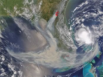
Andrea en rook van bosbranden
On Saturday, as the remnants of Andrea finally began moving out to sea, the tropical depression-ish low fired sporadic bursts of convection like the one near its center in the first image below, but overall the convection over the course of the weekend was never really persistent in an organized fashion and the system was not officially designated by the National Hurricane Center to be a depression. Today, as it moved farther northeast, the low started becoming less well-defined and is now merging with a cold front and becoming extratropical (as it was when everything began a week ago!).
Meanwhile, the fires keep burning, and the smoke persists from south Georgia and the eastern Gulf of Mexico across Florida and now even farther out into the Atlantic. On the second image below, there's a particularly dense concentration of smoke near the Georgia/Florida border in the area where road closures have resulted in slow-going for travelers. Hopefully the thunderstorms that have been scattered about the region at times this weekend have done more good (rain) than harm (wind and lightning).
weather.com (hier is ook een grotere foto te vinden)
[ Bericht 3% gewijzigd door #ANONIEM op 14-05-2007 21:58:58 ]
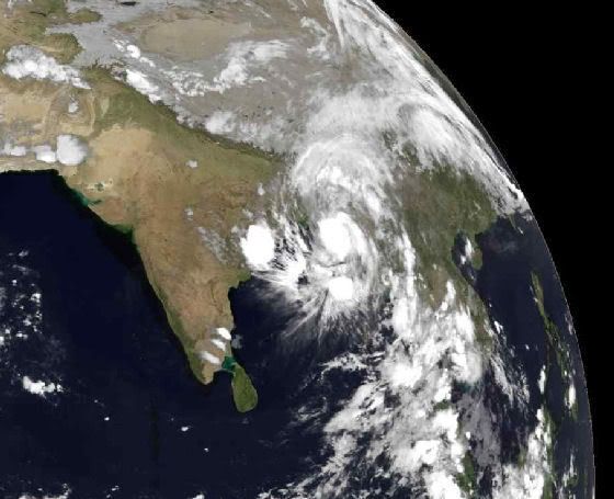
De cycloon Akash is gepromoveerd tot een catogorie 1 ! Dat is de eerste sinds lange tijden !!

2007 = Supper orkaan zeisoen !