WKN Weer, Klimaat en Natuurrampen
Lees alles over het onstuimige weer op onze planeet, volg orkanen en tornado's, zie hoe vulkanen uitbarsten en hoe Moeder Aarde beeft bij een aardbeving. Alles over de verwoestende kracht van onze planeet en tal van andere natuurverschijnselen.


Bron: Disasternews.netquote:BALTIMORE (May 19, 2005) —
Hurricane Adrian had killed two people and was damaging Central America’s Pacific coast by Thursday evening.
Some 2,500 people were evacuated from El Salvador, where schools were closed and fishing activities were banned, according to reports from Action by Churches Together (ACT), a global alliance of churches and related agencies that responds to emergencies worldwide.
The two deaths occurred in Guatemala, when a mudslide blamed on Adrian buried two construction workers near the Mexican border.
Forecasters warned Adrian could spawn flooding and mudslides in El Salvador, Guatemala and Honduras. The region was told to expect about 10 inches of rain, with as much as 20 inches in mountain areas.
Adrian was a Category 1 hurricane Thursday night, was expected to pick up speed before hitting El Salvador's coast.
By Thursday evening, Adrian was about 90 miles southwest of El Salvador's capital, San Salvador, with winds near 85 mph, according to the National Hurricane Center in Miami.
Faith-based groups were working closely with government officials in the region to prepare for the storm and to deploy an immediate response.
The ACT National Forum in El Salvador was activated to coordinate disaster preparedness activities with local community networks in Cara Sucia on the southwest coast.
In Guatemala and Honduras, government officials were setting up temporary shelters, and making transportation is available for evacuation activities. ACT Forums in both countries were activated to follow the situation.
In Nicaragua, people living in the lower areas of Managua - those living close to Xolotlan Lake - were evacuated. The local government announced it does not have the resources to assist the population with the evacuation, according to ACT.
The Salvation Army Team Emergency Radio Network (SATERN) was also planning to activate. SATERN helps train and acquire personnel skilled in emergency communications and message handling in disaster situations.
Adrian’s damage was not expected to approach that of Hurricane Mitch, which hit Central American in 1998, killing about 10,000 people in Honduras and Nicaragua.
The first hurricane of the Pacific season, Adrian has taken an unusual path - east instead of the usual west - toward the Caribbean. It is forecast to move across Central America, where it will likely break up over the mountains and be downgraded again to a tropical storm or tropical depression.
By Friday afternoon, the system was expected to continue on into the Caribbean and keep moving closer to Cuba. Forecasters said it would likely be out of the Caribbean by Monday morning. If the storm loses the circulation over the mountains and reforms over the Caribbean, it will get the name Arlene, the first name on the Atlantic names list for 2005.
According to weather historians, at least three storms have survived the trip over Central America in the past. The last one - an unnamed tropical storm - was in 1965. In 1923 and 1902, hurricanes survived the trek from the Pacific into the Gulf of Mexico.
The good news: Adrian might help relieve Cuba’s current drought.
Posted May 19, 2005 10:43 PM

Het is weer zover, vorig jaar volgde de ene op de andere storm in het Caribisch gebied en zorgde voor ravages en menselijk leed. Zal 2005 daar verandering in brengen?
We beginnen het jaar rustig met Adrian.
Op woensdag 24 sept. 2008 schreef Danny het volgende:
Dagonet doet onaardig tegen iedereen. Je bent dus helemaal niet zo bijzonder als je denkt...
Mijn grootste bijdrage aan de FP.
Dagonet doet onaardig tegen iedereen. Je bent dus helemaal niet zo bijzonder als je denkt...
Mijn grootste bijdrage aan de FP.

eikel
net vorige week met Alicey besproken dat ik sbel een nieuw topic zou openen over Season 2005 net als vorig jaar. Ut seizoen is immers nog niet begonnen Dit is de eerste van het PACIFISCHE seizoen ,neit van het Atlantische
Sorry Dago --> Kon ut niet laten Hurricane Season 2005 [Centraal Topic]
[ Bericht 17% gewijzigd door Frutsel op 20-05-2005 12:20:14 ]
Een tijdje terug las ik over ongewoon lage zeewatertemperaturen voor de kust van Florida. Als dat zo blijft kunnen ze in Florida en de omgeving redelijk opgelucht adem halen. Iemand anomaliekaartjes van de zeewatertemperatuur?quote:Op vrijdag 20 mei 2005 06:01 schreef Dagonet het volgende:
Het is weer zover, vorig jaar volgde de ene op de andere storm in het Caribisch gebied en zorgde voor ravages en menselijk leed. Zal 2005 daar verandering in brengen?
zoiets?quote:Op vrijdag 20 mei 2005 13:48 schreef Steijn het volgende:
[..]
Een tijdje terug las ik over ongewoon lage zeewatertemperaturen voor de kust van Florida. Als dat zo blijft kunnen ze in Florida en de omgeving redelijk opgelucht adem halen. Iemand anomaliekaartjes van de zeewatertemperatuur?


Nee, er moet ergens op internet een kaartje staan waarop de afwijking van het gemiddelde (met een duur woord heet dat anomalie) te zien is. Op dat kaartje was rondom floride een geheel blauw gebied te zien, fors lagere temperaturen dus ten opzichte van het gemiddelde.quote:
Hebbesquote:Op vrijdag 20 mei 2005 15:10 schreef Steijn het volgende:
[..]
Nee, er moet ergens op internet een kaartje staan waarop de afwijking van het gemiddelde (met een duur woord heet dat anomalie) te zien is. Op dat kaartje was rondom floride een geheel blauw gebied te zien, fors lagere temperaturen dus ten opzichte van het gemiddelde.

Nee, was een SSL verbinding, maar dat pakt Fok! blijkbaar niet. Even op mijn eigen server gezet.quote:Op vrijdag 20 mei 2005 15:24 schreef Frutsel het volgende:
1 foutje in https
Maar let dus op de lage zeewatertemperaturen bij Florida en voor de kust van Afrika, dat moet haast wel invloed hebben op de orkaan activiteit.
Lijkt me dat men niet voor niets een " boven gemiddelde waarschuwing uitdeelt" ...
dus het kon wel eens een zwaarder seizoen worden dan ' gemiddeld'..
zie centrale topic
Kom daar maar spammen Dit soort nuttige info die je net geeft is daar altijd welkom
dus het kon wel eens een zwaarder seizoen worden dan ' gemiddeld'..
zie centrale topic
Kom daar maar spammen Dit soort nuttige info die je net geeft is daar altijd welkom

quote:Hurricane Adrian Fizzles over Honduras
Posted May 20, 2005 6:53PM
Salvadoran President Tony Saca told local Channel 12 that officials were evaluating the damage, but said activities were turning to normal after the concern caused by the first hurricane on record to directly hit El Salvador.
Hurricane Adrian fizzled over Honduras Friday after slamming into El Salvador's coast and forcing the evacuation of 23,000 people, officials said.
The hurricane, first of the eastern Pacific season, caused relatively little damage and no reported deaths. It struck west of El Salvador's capital overnight with maximum sustained winds of almost 75 mph.
By midday, the rapidly moving storm had largely broken up over neighboring Honduras, leaving scattered showers, some flooding, blocked roads and the loss of a few shacks.
Officials linked one death to the storm. Rodrigo Flores, deputy chief of civil defense in Nicaragua, said a person drowned Thursday night during flooding in that country's capital, about 240 miles from the storm's center.
In Honduras, "there were no deaths or damage to mourn," said President Ricardo Maduro. "So we are fortunate."
Salvadoran President Tony Saca told local Channel 12 that officials were evaluating the damage, but said activities were turning to normal after the concern caused by the first hurricane on record to directly hit El Salvador.
He said most of the 23,000 people evacuated in El Salvador had returned home. The Salvadoran-based airline TACA also resumed service.
In Honduras, schools were closed as a precaution and many public workers were on a half-day schedule.
Officials in Guatemala and Nicaragua also reported some small-scale evacuations and flooding.
In 1998, Hurricane Mitch rolled across the region from the Caribbean side and killed at least 9,000 people.
 Hurricane Adrian fizzled over Honduras Friday after slamming into El Salvador's coast and forcing the evacuation of 23,000 people, officials said.
Op woensdag 24 sept. 2008 schreef Danny het volgende:
Dagonet doet onaardig tegen iedereen. Je bent dus helemaal niet zo bijzonder als je denkt...
Mijn grootste bijdrage aan de FP.
Dagonet doet onaardig tegen iedereen. Je bent dus helemaal niet zo bijzonder als je denkt...
Mijn grootste bijdrage aan de FP.
quote:Hurricane Dennis nears Jamaica
Storm could be menacing Gulf by weekend
Thursday, July 7, 2005; Posted: 2:51 a.m. EDT (06:51 GMT)
This satellite image shows Hurricane Dennis moving Wednesday though the Caribbean.
Hurricanes
MIAMI, Florida (CNN) -- People in Jamaica, southeastern Cuba and southwestern Haiti were bracing early Thursday for the menace of Dennis, which strengthened Wednesday to become the first full-fledged hurricane of the 2005 Atlantic season.
The storm is churning along a path toward the Gulf of Mexico, where it could begin threatening the U.S. Gulf Coast late this weekend.
As of 2 a.m. EDT, the center of Dennis, which was packing maximum sustained winds of almost 85 mph, was about 160 miles east-southeast of Kingston, Jamaica, and about 235 miles south-southeast of Guantanamo Bay, Cuba, according to the National Hurricane Center.
The storm, now a minimal Category 1 hurricane, was getting better-organized and was expected to strengthen, possibly reaching Category 2 status -- with winds in excess of 95 mph -- by the time it passes over or near Jamaica Thursday afternoon, forecasters said.
The strengthening Dennis was moving west-northwest at about 15 mph, and forecasters said that motion was expected to continue over the next 24 hours.
A hurricane warning was in effect for Jamaica, the southwestern peninsula of Haiti and the eastern Cuban provinces of Granma, Santiago de Cuba and Guantanamo. Hurricane conditions were expected in those areas within the next 24 hours, and forecasters warned people there to rush storm preparations to completion.
A hurricane watch in effect for the Cayman Islands was expected to be upgraded to a warning, forecasters said. Other portions of central and eastern Cuba were also under a hurricane watch.
Forecasters said the storm was expected to dump 4 inches to 8 inches of rain over southern Haiti, Jamaica, eastern Cuba and the Caymans, with isolated amounts of 12 inches possible in mountainous areas of Jamaica. The heavy rains could produce life-threatening flash floods and mudslides, forecasters warned.
Officials at the U.S. Navy base at Guantanamo Bay, Cuba, said that while hurricane preparations were under way, they did not expect to have to move the roughly 520 terror suspects held at a detention facility there.
With high winds expected, loose items were being secured, and a vehicle ferry from one side of the facility to the other was shut down, the officials said.
The hurricane center's latest five-day projection of Dennis' possible path has the center of the storm going across western Cuba Friday and then into the Gulf of Mexico. On that path, the storm would start approaching the central Gulf Coast Sunday and make landfall near Mobile, Alabama, about midday Monday.
However, hurricane movements can be erratic, and the potential forecast track of the storm varies from southwest Florida to Mexico's Yucatan peninsula. Forecasters cautioned that the storm was still too far away for a truly accurate prediction of where it would go.
However, forecasters said Dennis is likely to increase in intensity as it crosses the open waters of the Gulf of Mexico, possibly developing into a Category 3 hurricane with winds of more than 115 mph.
Cindy raises oil prices
Mobile is already swamped by rains from Tropical Storm Cindy, which came ashore late Tuesday near the mouth of the Mississippi River in Louisiana with sustained winds of 70 mph.
After coming ashore, Cindy faded into a tropical depression as it moved northward, but the system continued to drop rain on the southern Appalachians.
Cindy's move across the Gulf of Mexico forced the evacuation of 23 of 819 oil platforms and six of 135 oil rigs, according to the Minerals Management Service. Dennis' approach, as a stronger storm, could prompt more.
The shutdown has interrupted more than 3 percent of the Gulf's normal oil and natural gas production, pushing oil prices above $60 a barrel in trading Wednesday.

Heb liever dat hier een slot op gaat en het draadje hier heen gaat --> Tropical Cyclone Season 2005quote:Op donderdag 7 juli 2005 09:12 schreef Drugshond het volgende:
Tip : Kan een modje van dit topic een verzameldraadje maken, door de TT aan te passen
Evt daar de topictitel aanpassen

quote:
quote:Vijf doden in Haïti door orkaan Dennis
Uitgegeven op 08 juli 2005 om 12:35 uur, bijgewerkt om 12:52
(Novum/AP) - Zeker vijf mensen zijn donderdag in Haïti om het leven gekomen door een orkaan, die naar verwachting vrijdag Cuba zal bereiken. Vier mensen kwamen om het leven toen een brug instortte. Het vijfde slachtoffer bevond zich in een lemen hut die werd getroffen door een door de wind uit de grond gerukte palmboom.
Ook in Jamaïca richtte de orkaan, die Dennis is gedoopt, grote schade aan. Tien procent van de bevolking kwam zonder stroom te zitten. In Cuba zijn honderdduizend mensen uit voorzorg geëvacueerd.
Lekker dan, ik vertrek morgen naar Tampa, ben benieuwd of ik daar uberhaubt aan kan komen
|De nummer 1 van Limburg speelt haar wedstrijden in het Parkstad Limburg Stadion|
same herequote:Op vrijdag 8 juli 2005 14:55 schreef TheGHunter het volgende:
Lekker dan, ik vertrek morgen naar Tampa, ben benieuwd of ik daar uberhaubt aan kan komen
quote:Hurricane Dennis pummels Havana, 32 dead in Caribbean
By Anthony Boadle
HAVANA, July 9 (Reuters) - Deadly Hurricane Dennis pummeled Havana into the early morning hours on Saturday, uprooting trees and leaving the city's 2.2 million people in darkness after earlier killing 32 people in southeastern Cuba and Haiti.
The storm weakened as it crossed Cuba from a ferocious Category 4 hurricane on the five-step Saffir-Simpson scale to a less severe Category 2, but its 110-mph (180 kph) winds still screamed through the deserted streets of the Cuban capital, where many live in decrepit colonial buildings.
Residents said trees were plucked from the ground.
The U.S. National Hurricane Center in Miami said Dennis -- the strongest hurricane recorded so early in an Atlantic storm season -- would strengthen again on Saturday as it re-emerged over warm open water and skipped south of the Florida Keys.
Thousands of tourists and residents were evacuated from the vulnerable and low-lying island chain at the southern tip of the Florida peninsula, and many more prepared to leave coastal homes along the U.S. Gulf Coast, where Dennis was expected to land on Sunday evening.
Natural gas and oil production was also curtailed as oil platforms in the U.S. Gulf, where a quarter of U.S. crude and natural gas comes from, were evacuated.
Cuban authorities had evacuated more than 600,000 people in different parts of the country as Dennis approached the southern city of Cienfuegos. But the measures, which usually allow the Communist island to escape hurricane strikes with minimal casualties, failed to prevent 10 deaths on Thursday night.
Cuban President Fidel Castro said most of the victims died in collapsed houses in two coastal towns in Granma province. An 18-day-old baby was among those who died, he said on state television, calling the hurricane a "diabolical force."
Officials said 15,400 of the adjacent towns' 20,000 homes were destroyed or damaged. Television images showed rows of clapboard houses flattened by the storm.
On Friday, gusts of up to 149 mph (240 kph) also caused extensive damage in Cienfuegos, where the storm made landfall. It ripped up trees and downed electricity lines, but no casualties were reported there.
In southern Haiti, 15 people died when a swollen river tore away a bridge. The total number of deaths in Haiti reached 22, according to various officials.
 HAVANA, July 9 (Reuters) - Deadly Hurricane Dennis pummeled Havana into the early morning hours on Saturday, uprooting trees and leaving the city's 2.2 million people in darkness after earlier killing 32 people in southeastern Cuba and Haiti.
 Officials said 15,400 of the adjacent towns' 20,000 homes were destroyed or damaged. Television images showed rows of clapboard houses flattened by the storm.
Op woensdag 24 sept. 2008 schreef Danny het volgende:
Dagonet doet onaardig tegen iedereen. Je bent dus helemaal niet zo bijzonder als je denkt...
Mijn grootste bijdrage aan de FP.
Dagonet doet onaardig tegen iedereen. Je bent dus helemaal niet zo bijzonder als je denkt...
Mijn grootste bijdrage aan de FP.
Orkaan Dennis is op dit moment krachtiger dan "Ivan" die vorig jaar de golf van Mexico trof. 10 miljoen amerikanen maken zich op de voor de eerste echte storm van 2005 die waarschijnlijk vanmiddag Alabama bereikt.
[ Bericht 44% gewijzigd door Frutsel op 10-07-2005 11:12:27 ]


[ Bericht 44% gewijzigd door Frutsel op 10-07-2005 11:12:27 ]

Cuba heeft behoorlijk te lijden gehad, hoewel het nomaal gesproken het land is dat het beste georganiseerd is met dit soort dingen. Contact met een Cubaanse vriend is al dagen onmogelijk, blijkbaar ligt de electriciteit er al meer dan 36 uur uit.
Als vakantieganger zul je er weinig van merken (behalve een dagej binnenblijven), maar voor de Cubanen wordt het leven er (andermaal) niet makkelijker op...
Als vakantieganger zul je er weinig van merken (behalve een dagej binnenblijven), maar voor de Cubanen wordt het leven er (andermaal) niet makkelijker op...
Travel is fatal to prejudice,bigotry and narrow-mindedness and many of our people need it solely on these accounts. Broad, wholesome, charitable views of men and things cannot be acquired by vegetating in one corner of the earth all one's lifetime.
quote:Orkaan Dennis bereikt Amerikaanse kust
Uitgegeven op 10 juli 2005 om 22:13 uur
(Novum/AP) - Na zeker twintig dodelijke slachtoffers te hebben gemaakt in Haïti en Cuba heeft de orkaan Dennis zondag de zuidkust van de Verenigde Staten bereikt. Honderdduizenden mensen in de staten Florida en Alabama, waar de orkaan aan land ging, zijn geëvacueerd, evenals mensen uit de nabijgelegen staat Mississippi. De orkaan heeft voor de kust iets aan kracht verloren, maar nog steeds werden gevaarlijk hoge windsnelheden van ruim 190 kilometer per uur gemeten.
De meeste doden in Cuba vielen in de zuidoostelijke provincies. Volgens de autoriteiten hadden meer dan 1,5 miljoen Cubanen hun huizen verlaten en elders onderdak gezocht. Volgens de Cubaanse leider Fidel Castro vonden desalniettemin tien mensen de dood. De schade aan de Amerikaanse marinebasis Guantanamo Bay is beperkt gebleven tot een ingestorte wachttoren en een omgewaaide omheining.
Na op Cuba wat aan kracht te hebben verloren, zwol Dennis op zee weer aan tot een orkaan van de vierde categorie, waarbij windsnelheden zijn gemeten van 230 kilometer per uur. Sinds juni 1957, toen de orkaan Elizabeth de kust van Texas en Louisiana teisterde, zijn de VS niet meer zo vroeg in het jaar aangedaan door een orkaan.


Het gloednieuwe boorplatform Thunder Horse na Dennis. Ding staat punt van op zinken. Het platform was nog niet in gebruik, kostte één miljard dollar en is het grootste platform ter wereld.
Bron: Reutersquote:BP in race against time to secure tilting platform
NEW YORK (Reuters) - BP workers in the Gulf of Mexico are racing to level the company's Thunder Horse oil platform, which is tilting precariously following Hurricane Dennis, before the possible arrival of another storm.
Thunder Horse, the largest semi-submersible oil platform in the world, had become more secure overnight, BP said on Wednesday.
A team of engineers on board is inspecting the damage and working to start pumps in an attempt to level the platform, which is listing 20 degrees, with its lower deck almost touching the water.
The tilting was discovered Monday, after the facility was evacuated Friday due to the approach of Hurricane Dennis.
Their work could be hindered by Tropical Storm Emily, which is moving westward from the Atlantic.
BP, the world's second-largest oil company by market capitalization, has said it does not know what caused the problem.
Thunder Horse, which cost $1 billion (567,996 billion pounds), is seen as the biggest hope for a small recovery in U.S. crude production, which has been falling since the 1970s. It was scheduled to start producing oil and gas in the fourth quarter of 2005.
"Chances are it will be delayed, how long and how much is still being discussed," said Mir Yousufuddin, an upstream oil analyst at the U.S Energy Information Administration.
BP owns 75 percent of Thunder Horse, with Exxon Mobil holding the rest. Both majors self-insure their portions of the platform.
BP said a survey by unmanned miniature submarines had not found any damage to Thunder Horse's hull. Analysts said this suggested a problem with its ballast tanks.
Op woensdag 24 sept. 2008 schreef Danny het volgende:
Dagonet doet onaardig tegen iedereen. Je bent dus helemaal niet zo bijzonder als je denkt...
Mijn grootste bijdrage aan de FP.
Dagonet doet onaardig tegen iedereen. Je bent dus helemaal niet zo bijzonder als je denkt...
Mijn grootste bijdrage aan de FP.
Dat is nog eens een vette kater voor BP en Exxon Mobilquote:Op donderdag 14 juli 2005 08:16 schreef Dagonet het volgende:
[afbeelding]
Het gloednieuwe boorplatform Thunder Horse na Dennis. Ding staat punt van op zinken. Het platform was nog niet in gebruik, kostte één miljard dollar en is het grootste platform ter wereld.
[..]
Bron: Reuters

Next up:
Emily

Emily
quote:Eastern Caribbean wary as Emily draws near
Jul 13, 05: MIAMI (Reuters) - Hurricane alerts were issued on Tuesday for some small eastern Caribbean islands as Tropical Storm Emily raced across the Atlantic Ocean.
Residents of Barbados, St. Vincent and the Grenadines, St. Lucia and Grenada, which was devastated by Hurricane Ivan last year, were told they could face hurricane conditions within 24 hours.
The government of energy-rich Trinidad and Tobago issued a tropical storm warning for the island of Tobago. France cautioned residents of Martinique to be ready for storm conditions.
Emily, the fifth tropical storm or hurricane of the busy Atlantic season, formed late on Monday and by 5 p.m. EDT (2100 GMT) on Tuesday was about 475 miles east-southeast of Barbados, the U.S. National Hurricane Center said.
Sustained winds had grown to 50 mph (80 kph) and the storm was moving to the west at about 20 mph (32 kph).
Forecasters said Emily could reach hurricane strength, with 74 mph (119 kph) winds, by the time it reaches the Windward Islands, on the eastern rim of the Caribbean Sea, by late Wednesday or early Thursday.
Hurricane Ivan damaged 90 percent of Grenada's housing when it hit in September. It caused $2.2 billion in damage, more than double the island's annual economic output, and officials said it would take Grenada 10 years to fully recover.
Emily follows hot on the heels of Hurricane Dennis, which rampaged through the Caribbean and then slammed into the U.S. Gulf Coast on Sunday.
Op woensdag 24 sept. 2008 schreef Danny het volgende:
Dagonet doet onaardig tegen iedereen. Je bent dus helemaal niet zo bijzonder als je denkt...
Mijn grootste bijdrage aan de FP.
Dagonet doet onaardig tegen iedereen. Je bent dus helemaal niet zo bijzonder als je denkt...
Mijn grootste bijdrage aan de FP.
http://www.bucuticam.com/tarabeach.html
Aruba cam
Centrum van categorie 4 orkaan Emily zal om 2:00pm Nederlandse tijd ten noorden van Aruba razen op een afstand van 190km. Vanmorgen is er op Aruba melding van noodweer op verschillende plekken.
Aruba cam
Centrum van categorie 4 orkaan Emily zal om 2:00pm Nederlandse tijd ten noorden van Aruba razen op een afstand van 190km. Vanmorgen is er op Aruba melding van noodweer op verschillende plekken.

quote:
quote:Orkaan Emily richting Jamaica
Gepubliceerd op vrijdag 15 juli 2005
Orkaan Emily is sterker geworden en is onderweg naar Jamaica. De orkaan, die donderdag nog een dodelijk slachtoffer eiste op Grenada, is inmiddels in kracht toegenomen tot categorie 4 op de schaal van Saffir-Simpson. Die telt vijf categoriën. Er zijn windsnelheden gemeten van 217 kilometer per uur.
Er is een evacuatieplan opgesteld in Jamaica, in afwachting van de tweede orkaan van het seizoen. Nog geen week geleden kostte orkaan Dennis aan meer dan twintig mensen het leven terwijl het over Jamaica, Cuba en Florida heentrok.
Antillen
Emily zal vermoedelijk weinig schade aanrichten op de ABC-eilanden, zo heeft de Meteorologische Dienst van de Antillen en Aruba donderdagavond bekendgemaakt. Volgens de laatste voorspellingen passeert het oog van de orkaan het noorden van Curaçao op 195 kilometer.
Omdat de ergste stormwinden voorkomen op een afstand van 150 kilometer tot het oog, zal de schade vermoedelijk meevallen, zei meteoroloog Albert Martis. Voor donderdagnacht worden wel hevige regen- en onweersbuien verwacht en een wind met kracht 7 tot 9.
Martis waarschuwde dat orkanen onverwachte bewegingen kunnen maken als ze in hevigheid toenemen, zodat de kans blijft bestaan dat de stormwinden wel over Curaçao, Bonaire en Aruba razen. De waarschuwing voor een tropische storm die sinds zeven uur donderdagochtend geldt op de benedenwindse eilanden, blijft daarom van kracht.
Tis inmiddels een categorie 4 stormpje....
Lekker om nu naar de caribbean op vakantie te moeten
[ Bericht 70% gewijzigd door Frutsel op 16-07-2005 13:11:57 ]
Lekker om nu naar de caribbean op vakantie te moeten
[ Bericht 70% gewijzigd door Frutsel op 16-07-2005 13:11:57 ]
Kijk eens in Azie... wat daar morgen over taiwan heen komt.
De beschrijving : Super Typhoon !! ,
Dat is wel een joekeltje.

De beschrijving : Super Typhoon !! ,

Dat is wel een joekeltje.
Die heeft zelfs z'n eigen topic drugshond
Bron: Houston Chroniclequote:EMILY TAKES DANGEROUS PATH ACROSS YUCATAN
Tourists caught in hurricane's grip seek shelter as resorts are hit
By DUDLEY ALTHAUS
Copyright 2005 Houston Chronicle
TULUM, MEXICO - Thousands of tourists and locals fled Hurricane Emily's 135 mph winds Sunday as it began churning across the Yucatan Peninsula and heading toward northern Mexico and South Texas.
After crossing the peninsula, Emily is expected to gather strength over the Gulf of Mexico, and could bring high winds and rain to South Texas by late Tuesday. Some residents were already bracing for it.
"We're boarding up the windows with wood," said Sophie Trevino, 23, a Cameron County Sheriff's Department dispatcher in Brownsville. "We think we'll get some wind and at least some rain."
Copying the path that the deadly Hurricane Gilbert took in 1988, the compact but fierce Category 4 Emily — the strongest storm this early in the hurricane season since record-keeping began 140 years ago — was expected to
make landfall again in Tamaulipas state, south of Brownsville.
In Tulum, the surge ahead of the storm came up to the first floors of some beachside hotels, according to radio reports. Tens of thousands of tourists were evacuated from the main hotel strip in Cancun, Islas Mujeres and the island of Cozumel late Sunday night.
After shutting off 63 offshore oil wells Saturday, Mexico began closing oil-exporting ports in the southern Gulf on Sunday. The state oil monopoly, Pemex, continued to operate its refinery in Tabasco state, but output was down by a quarter.
Two pilots died when their helicopter crashed during evacuation of 15,000 workers from oil platforms in the Bay of Campeche, on the western side of the Yucatan.
In Jamaica, four people were swept away in a car.
In the Yucatan, tourists and residents who could leave did so by the thousands. Those who couldn't get out spent Sunday arranging shelter.
"I tried to get out of here and there is just no way," said Jeani Bedore, 49, a school principal and mother of two from Oregon who owns a condominium in Playa del Carmen, about 45 miles south of Cancun. "Talk about freaky."
State officials said 20,000 tourists had flown out of Cancun airport Saturday and Sunday. But many flights were canceled, and the airport was closed at 5 p.m. Sunday.
At least 4,000 tourists were taken to public shelters while several thousand others bedded down in 32 hotel lobbies, city authorities said.
Hundreds of mostly foreign tourists lay shoulder-to-shoulder on thin foam pads in a sweltering gymnasium near the center of Cancun, authorities said. Power was knocked out to most of Cancun and Playa del Carmen.
In a heavily Maya Indian area south of Cancun, residents refused to evacuate.
"They don't want to leave," a frustrated Quintana Roo Gov. Felix Gonzalez told state radio after flying into the area to persuade the villagers. "They don't see a need to."
When Gilbert hit 17 years ago, Cancun had just 8,000 hotel rooms and perhaps 75,000 residents. Dubbed the Maya Riviera by promoters, today the city has 50,000 rooms and 300,000 inhabitants.
Mexican officials, who once viewed hurricanes with some nonchalance, have begun taking them more seriously.
"We now have a hurricane culture," Francisco Tenreiro said as he tied down the boats he rents on the beach in Playa del Carmen.
The government of Quintana Roo state urged residents in more vulnerable areas — especially the slums surrounding Cancun and some coastal towns — into shelters.
"The trouble is that a lot of people just arrived here and have no idea about hurricanes," said Samuel Gonzalez, a manager at a beachfront hotel in Playa del Carmen. "They don't pay attention to the government bulletins because they don't understand them."
Itinerant construction workers, who have flocked here from across southern Mexico for $90-a-week jobs, are accustomed to sleeping at the construction sites. Many were turned out by the police Sunday morning.
"We're surrounded by water, so this isn't safe at all," said Gaspar Perez, 18, from Tabasco. "We're used to such storms in my town, but not so powerful and not so direct. This is very dangerous here."
Other storms have hit the Yucatan since Gilbert, but none as powerful as Emily.
Reporter Dale Lezon and Chronicle wire services contributed to this report.
 After crossing the peninsula, Emily is expected to gather strength over the Gulf of Mexico, and could bring high winds and rain to South Texas by late Tuesday. Some residents were already bracing for it.
Op woensdag 24 sept. 2008 schreef Danny het volgende:
Dagonet doet onaardig tegen iedereen. Je bent dus helemaal niet zo bijzonder als je denkt...
Mijn grootste bijdrage aan de FP.
Dagonet doet onaardig tegen iedereen. Je bent dus helemaal niet zo bijzonder als je denkt...
Mijn grootste bijdrage aan de FP.

quote:Mississippi en Louisiana roepen noodtoestand uit
MIAMI/WASHINGTON - De Amerikaanse staten Mississippi en Louisiana hebben vrijdag de noodtoestand uitgeroepen in afwachting van orkaan Katrina. De orkaan die minstens zeven levens eiste in Florida is kracht aan het verzamelen boven de Golf van Mexico en komt mogelijk maandag weer aan land, meldde het Amerikaanse Nationale Orkanen Centrum in Miami.
Meteorologen houden er rekening mee dat Katrina uit kan groeien tot een orkaan uit categorie vier van de Saffir-Simpson schaal. De wind kan daarbij snelheden bereiken tussen de 210 en 250 kilometer per uur. Volgens het Nationale Orkanen Centrum zal de orkaan vermoedelijk de kust van Louisiana of Mississippi treffen.
Evacuatie
In deze laatste staat kan zaterdagmiddag met de evacuatie van toeristen worden begonnen. De bewoners van de kuststreek moeten uiterlijk op zondag hun huizen verlaten. De autoriteiten in Louisiana hebben gedetailleerde plannen klaarliggen voor een eventuele evacuatie. De stad New Orleans ligt mogelijkerwijs midden op het pad van Katrina.
In 1969 trof een orkaan uit de vierde categorie Louisiana en Mississippi voor het laatst. Camille eiste toen 143 levens. Katrina heeft volgens deskundigen nu al voor honderden miljoenen dollars schade aangericht in de VS.
Katrina kan best nog wel eens gevaarlijk worden voor New Orleans, zeker gezien het feit dat het daar een grote polder is. Komende dagen zullen we wel beelden van overstromingen te zien krijgen.

Inderdaad steyn. Heb een documentaire hierover gezien. Als ik me goed herinner bevind New Orleans zich onder zeeniveau en is omringd door stadswallen ter beveiliging. Er werd in de docu gesugereerd dat een krachtige orkaan de potentie had om New Orleans onder water te zetten.quote:Op zaterdag 27 augustus 2005 13:23 schreef Steijn het volgende:
Katrina kan best nog wel eens gevaarlijk worden voor New Orleans, zeker gezien het feit dat het daar een grote polder is. Komende dagen zullen we wel beelden van overstromingen te zien krijgen.
[afbeelding]
Nu Katrina is inmiddels aangesterkt tot een catagorie 5 hurricane, in de eyewall (het gebied met de hoogste windsnelheden) zijn windsnelheden gemeten van 153 knopen per uur ofwel 275 km/u. New Orleans lijkt op haar koers te liggen zodat de rampscenario's uit de kast zijn gehaald. De kerndruk is gedaald tot 908 hPa, en de voorspelde neerslag is 44 inch (dus zo 1100 mm) in 24 uur, zeer gevaarlijk dus.
Het worstcase scenario, dit kaartje gaat uit van een catagorie 4 hurricane, Katrina is dus nog een slagje sterker. Een koers ten noord-oosten van de baai is het meest ernstig.
De koers van Katrina zoals die voorspeld wordt komt akelig dicht bij het worstcase scenario in de buurt. Als je tussen die twee punten interpoleert komt Katrina met haar oog dicht in de buurt van de monding van de baai bij New Orleans.
Het worstcase scenario, dit kaartje gaat uit van een catagorie 4 hurricane, Katrina is dus nog een slagje sterker. Een koers ten noord-oosten van de baai is het meest ernstig.

De koers van Katrina zoals die voorspeld wordt komt akelig dicht bij het worstcase scenario in de buurt. Als je tussen die twee punten interpoleert komt Katrina met haar oog dicht in de buurt van de monding van de baai bij New Orleans.

Zit net CNN te kijken, Categorie 5 storm inmiddels geworden. Hele stad is bezig om zich voor te bereiden op wat er komen gaat. De Dome is in gebruik genomen een schuilkelder welke alleen bij stormen boven de categorie 2 open gaat.
-
http://goes.gsfc.nasa.gov(...)olor/0000_latest.jpg
Iedereen in New Orleans wordt aangeraden de stad te verlaten, 500.000 mensen
Iedereen in New Orleans wordt aangeraden de stad te verlaten, 500.000 mensen
Mooie plaat. Ik lees in de berichtgeving dat zelfs deskundigen opkijken van de kracht en het gedrag van Katrina. Dinsdag weten we meer.quote:Op zondag 28 augustus 2005 17:54 schreef Darklight het volgende:
http://goes.gsfc.nasa.gov(...)olor/0000_latest.jpg
Iedereen in New Orleans wordt aangeraden de stad te verlaten, 500.000 mensen
Ze worden niet aangeraden, maar zelfs verplicht te evacueren..quote:Op zondag 28 augustus 2005 17:54 schreef Darklight het volgende:
http://goes.gsfc.nasa.gov(...)olor/0000_latest.jpg
Iedereen in New Orleans wordt aangeraden de stad te verlaten, 500.000 mensen
http://209.16.77.221/portal.aspx?portal=1&tabid=43quote:A mandatory evacuation order is hereby called for all of the Parish of Orleans, with only the following exception...
Holy smoke, ze verwachten een apocalyps:
quote:URGENT - WEATHER MESSAGE
NATIONAL WEATHER SERVICE NEW ORLEANS LA
1011 AM CDT SUN AUG 28 2005
DEVASTATING DAMAGE EXPECTED
HURRICANE KATRINA
A MOST POWERFUL HURRICANE WITH UNPRECEDENTED
STRENGTH...RIVALING THE INTENSITY OF HURRICANE CAMILLE OF 1969.
MOST OF THE AREA WILL BE UNINHABITABLE FOR WEEKS...PERHAPS LONGER. AT
LEAST ONE HALF OF WELL CONSTRUCTED HOMES WILL HAVE ROOF AND WALL
FAILURE. ALL GABLED ROOFS WILL FAIL...LEAVING THOSE HOMES SEVERELY
DAMAGED OR DESTROYED.
THE MAJORITY OF INDUSTRIAL BUILDINGS WILL BECOME NON FUNCTIONAL.
PARTIAL TO COMPLETE WALL AND ROOF FAILURE IS EXPECTED. ALL WOOD
FRAMED LOW RISING APARTMENT BUILDINGS WILL BE DESTROYED. CONCRETE
BLOCK LOW RISE APARTMENTS WILL SUSTAIN MAJOR DAMAGE...INCLUDING SOME
WALL AND ROOF FAILURE.
HIGH RISE OFFICE AND APARTMENT BUILDINGS WILL SWAY DANGEROUSLY...A
FEW TO THE POINT OF TOTAL COLLAPSE. ALL WINDOWS WILL BLOW OUT.
AIRBORNE DEBRIS WILL BE WIDESPREAD...AND MAY INCLUDE HEAVY ITEMS SUCH
AS HOUSEHOLD APPLIANCES AND EVEN LIGHT VEHICLES. SPORT UTILITY
VEHICLES AND LIGHT TRUCKS WILL BE MOVED. THE BLOWN DEBRIS WILL CREATE
ADDITIONAL DESTRUCTION. PERSONS...PETS...AND LIVESTOCK EXPOSED TO THE
WINDS WILL FACE CERTAIN DEATH IF STRUCK.
POWER OUTAGES WILL LAST FOR WEEKS...AS MOST POWER POLES WILL BE DOWN
AND TRANSFORMERS DESTROYED. WATER SHORTAGES WILL MAKE HUMAN SUFFERING
INCREDIBLE BY MODERN STANDARDS.
THE VAST MAJORITY OF NATIVE TREES WILL BE SNAPPED OR UPROOTED. ONLY
THE HEARTIEST WILL REMAIN STANDING...BUT BE TOTALLY DEFOLIATED. FEW
CROPS WILL REMAIN. LIVESTOCK LEFT EXPOSED TO THE WINDS WILL BE
KILLED.
AN INLAND HURRICANE WIND WARNING IS ISSUED WHEN SUSTAINED WINDS NEAR
HURRICANE FORCE...OR FREQUENT GUSTS AT OR ABOVE HURRICANE FORCE...ARE
CERTAIN WITHIN THE NEXT 12 TO 24 HOURS.
ONCE TROPICAL STORM AND HURRICANE FORCE WINDS ONSET...DO NOT VENTURE
OUTSIDE!
LAZ038-040-050-056>070-282100-
ASSUMPTION-LIVINGSTON-LOWER JEFFERSON-LOWER LAFOURCHE-
LOWER PLAQUEMINES-LOWER ST. BERNARD-LOWER TERREBONNE-ORLEANS-
ST. CHARLES-ST. JAMES-ST. JOHN THE BAPTIST-ST. TAMMANY-TANGIPAHOA-
UPPER JEFFERSON-UPPER LAFOURCHE-UPPER PLAQUEMINES-UPPER ST. BERNARD-
UPPER TERREBONNE-
1011 AM CDT SUN AUG 28 2005
Hoe laat onze tijd wordt ze ongeveer verwacht?
Stroek: Sitethief, die is heel groot en sterk :Y.
Faat: *zucht* zoals gewoonlijk hoor Sitethief weer in de bocht >:)
Faat: *zucht* zoals gewoonlijk hoor Sitethief weer in de bocht >:)
Maandagavond. De luchtdruk in het oog is nu trouwens gezakt naar 902 hPa, op vier orkanen na een luchtdrukrecord. De doorstaande windsnelheid bedraagt nu 280 km/u met windstoten tot 331 km/u. De lage luchtdruk zorgt bovendien voor een zeer hoge stormvloed, het water wordt als het ware omhoog gezogen, en daar bij bovenop komt nog de stormvloed (windopstuwing) en de golfopslag.quote:Op zondag 28 augustus 2005 20:31 schreef Sitethief het volgende:
Hoe laat onze tijd wordt ze ongeveer verwacht?


http://www.nos.nl/nosjour(...)leans_geografie.htmlquote:New Orleans in dodelijke kom 28-08-05
Satellietfoto van New Orleans, gemaakt in 2000 (Foto: Robert Simmon, gebaseerd op data beschikbaar gesteld door het Landsat 7 Science Team)
New Orleans en Nederland kampen met hetzelfde probleem: beide gebieden liggen meters onder de waterspiegel en zijn ingeklemd door water.
Net als Nederland wordt New Orleans beschermd door een complex systeem van dijken. Hoge dijken tegen de rivier Mississippi en iets lagere om te beschermen tegen het water van het meer Pontchartrain.
Een uitgebreid moeras ligt als buffer tussen de stad en het zeewater van de Golf van Mexico, enkele tientallen kilometers verder.
Gevaar
Maar dezelfde dijken die de stad moeten beschermen, leveren ook een gevaar op. Net als tijdens de Waternoodramp in 1953, toen een stormvloed het water over de dijken van Zeeland stuwde, loopt New Orleans het risico dat een zware orkaan het water uit de Golf van Mexico en uit Pontchartrain over de dijken spoelt.
Daarbij komt nog het vele hemelwater dat zo'n orkaan met zich meebrengt.
De geografische kom waarin de stad van jazz, carnaval en petrochemische industrie ligt, loopt dan vol met water. In het dunbevolkte Zeeland kostte zo'n overstroming in 1835 mensen het leven, maar in de stad New Orleans wonen 500.000 mensen...
Gemalen
Tot nu toe is de stad altijd ontsnapt aan de volle impact van een zware orkaan. Het centrum loopt bij zware regen weliswaar onder water, maar de gemalen die overal in de stad staan, voeren het water snel weer af.
Hamvraag is of die gemalen opgewassen zijn tegen het vele water dat een orkaan van de zwaarste categorie met zich meebrengt. Deskundigen betwijfelen dat. En als het water niet snel genoeg wordt afgevoerd, wordt de energietoevoer onderbroken en vallen de gemalen stil.
En dan zal de stad zal onder meters water komen te liggen.

En het 'gebied' groeit nog steeds.quote:Op zondag 28 augustus 2005 20:49 schreef aloa het volgende:
Je ziet ook duidelijk het oog zitten
[afbeelding]
[afbeelding]
Wetteronline meldt @ http://www.wetteronline.de/cgi-bin/sturmframe?LANG=de&GEBIET=atl&STURM=katrina&JJ=xxxx&MM=08&TT=26&ART=txt zelfs snelheden tot 343 km/uur .quote:Op zondag 28 augustus 2005 20:47 schreef Steijn het volgende:
[..]
Maandagavond. De luchtdruk in het oog is nu trouwens gezakt naar 902 hPa, op vier orkanen na een luchtdrukrecord. De doorstaande windsnelheid bedraagt nu 280 km/u met windstoten tot 331 km/u. De lage luchtdruk zorgt bovendien voor een zeer hoge stormvloed, het water wordt als het ware omhoog gezogen, en daar bij bovenop komt nog de stormvloed (windopstuwing) en de golfopslag.
Veel mensen zijn ook in die Superdome in NO:
They were interviewing some Colonel who is in charge of the operation at the Superdome. There are 10,000 people there now, and more arriving. It is a "shelter of last resort". No food will be provided. They are searching people as they arrive for weapons and drugs. They assume power will be off. There will be no air conditioning. He is saying that the ground floor of the building and the playing field will be flooded.
"It´s not about being comfortable, or tolerable. It´s about being alive on Tuesday."
Ik vraag me sws af waarom die 'dome' veiliger zou zijn dan elders. Eén keer de wind eronder en dat dak vliegt er letterlijk vanaf. Of zit daar een mooie kelder onder ofzo?
wow das een beste...
When you are courting a nice girl an hour seems like a second. When you sit on a red-hot cinder a second seems like an hour. That's relativity.
Het ziet er wel massief uit.quote:Op zondag 28 augustus 2005 23:05 schreef Roel_Jewel het volgende:
Ik vraag me sws af waarom die 'dome' veiliger zou zijn dan elders. Eén keer de wind eronder en dat dak vliegt er letterlijk vanaf. Of zit daar een mooie kelder onder ofzo?

Ehm, iedereen zal wel in het gebouw zelf ondergebracht worden, en niet op het veld of de tribunes..quote:Op zondag 28 augustus 2005 23:05 schreef Roel_Jewel het volgende:
Ik vraag me sws af waarom die 'dome' veiliger zou zijn dan elders. Eén keer de wind eronder en dat dak vliegt er letterlijk vanaf. Of zit daar een mooie kelder onder ofzo?
Edit:
The Superdome is built to withstand catastrophes; the roof is built to stand up to 200 MPH wind and even deep flood water wouldn't reach the second level 35 feet from the ground. It has thus been used as an emergency shelter but is not designed for the task; in 1998 during Hurricane Georges problems included looting and supplying 14,000 people with necessities. Most recently, it is being considered a last-ditch shelter for those in New Orleans unable to evacuate from Hurricane Katrina.
[ Bericht 33% gewijzigd door Murray op 28-08-2005 23:33:38 ]
Is geen klein ding nee, zat ik ook al net naar te kijken..quote:Op zondag 28 augustus 2005 23:26 schreef Steijn het volgende:
[..]
Het ziet er wel massief uit.
[afbeelding]
Geil!quote:The Superdome is a massive structure located on 52 acres (210,000 m²) of land; the dome has an interior space of 125,000,000 ft³ (3,500,000 m²), a height of 253 feet (82.3 meters), a dome diameter of 680 feet (210 meters), and a total floor area of 269,000 ft² (25,000 m²), making it the largest domed structure in the world.
http://en.wikipedia.org/wiki/Superdome
http://maps.google.com/maps?ll=29.951253,-90.081110&spn=0.006058,0.010131&t=k&hl=en
Nee, psies. Maar dan nog: waarom is dat gebouw steviger dan al die andere gebouwen in de stad? En ligt die Dome veel hoger dan andere gebouwen?quote:Op zondag 28 augustus 2005 23:27 schreef Murray het volgende:
[..]
Ehm, iedereen zal wel in het gebouw zelf ondergebracht worden, en niet op het veld of de tribunes..
Zie ook edit.quote:Op zondag 28 augustus 2005 23:31 schreef Roel_Jewel het volgende:
[..]
Nee, psies. Maar dan nog: waarom is dat gebouw steviger dan al die andere gebouwen in de stad? En ligt die Dome veel hoger dan andere gebouwen?
En als basissctuctuur lijkt het mij een enorm groot rond blok beton, denk dat ik daar liever inzit i.p.v. in een wolkenkrabber ofzo.
Ah, owkee. Dank voor de info .quote:Op zondag 28 augustus 2005 23:31 schreef Murray het volgende:
[..]
Is geen klein ding nee, zat ik ook al net naar te kijken..
[..]
Geil!
http://en.wikipedia.org/wiki/Superdome
http://maps.google.com/maps?ll=29.951253,-90.081110&spn=0.006058,0.010131&t=k&hl=en
Dit is een grote jongen en wordt steeds groter vanwege het relatief warme water, nieuwszenders berichten erg veel nu.
Verwachting is dat grote gebieden straks voor weken of maanden niet bewoonbaar zijn.
Ben blij dat ik niet daar woon.
Verwachting is dat grote gebieden straks voor weken of maanden niet bewoonbaar zijn.
Ben blij dat ik niet daar woon.
Patience is not one of my virtues, neither is memory. Or patience for that matter.
http://edition.cnn.com/20(...)e.katrina/index.html :
Zie ook het verwachte pad:
En dan komt de schade verder landinwaarts er nog bij. Want dat geval is natuurlijk niet direct opgelost ....quote:"There will be extensive to potentially catastrophic damage to many structures ... and inland," he said. "We'll have a lot of trees that are going to come down, perhaps millions of trees. But the first threat is going to be the storm surge. You must get away from the coast now."
National Hurricane Center director Max Mayfield said: "There's certainly a chance it can weaken a bit before it gets to the coast, but unfortunately this is so large and so powerful that it's a little bit like the difference between being run over by an 18-wheeler or a freight train. Neither prospect is good."
Zie ook het verwachte pad:

Ja, we krijgen in Michigan toch nog iets mee.
Lekker briesje waarschijnlijk.
Lekker briesje waarschijnlijk.
Patience is not one of my virtues, neither is memory. Or patience for that matter.
Geniet er maar van .quote:Op maandag 29 augustus 2005 00:08 schreef popolon het volgende:
Ja, we krijgen in Michigan toch nog iets mee.
Lekker briesje waarschijnlijk.
Ga als ramptoerist nieuws kijken men maakt zich terecht meer zorgen dan normaal.quote:
Mayor New Orleans orders full evacuation, chaos op de snelwegen nu.
Patience is not one of my virtues, neither is memory. Or patience for that matter.
D'r is een gozer aan het surfen nu aan de kust van Alabama.
Wat een gek
Wat een gek
Patience is not one of my virtues, neither is memory. Or patience for that matter.
Hurricane Mitch of 1998 was a Category Five hurricane at peak intensity over the western Caribbean. Hurricane Gilbert of 1988 was a Category Five hurricane at peak intensity and is one of the strongest Atlantic tropical cyclones of record.
7 jaar geleden was de laatste cat.5 orkaan dus.
7 jaar geleden was de laatste cat.5 orkaan dus.
Patience is not one of my virtues, neither is memory. Or patience for that matter.
Ivan vorig jaar was ook cat. 5.quote:Op maandag 29 augustus 2005 00:55 schreef popolon het volgende:
Hurricane Mitch of 1998 was a Category Five hurricane at peak intensity over the western Caribbean. Hurricane Gilbert of 1988 was a Category Five hurricane at peak intensity and is one of the strongest Atlantic tropical cyclones of record.
7 jaar geleden was de laatste cat.5 orkaan dus.
Oh ok.
Volgens Fox is dit één van de sterkste ooit die de VS gaat treffen.
Volgens Fox is dit één van de sterkste ooit die de VS gaat treffen.
Patience is not one of my virtues, neither is memory. Or patience for that matter.
Mijn auto staat in een kleine garage zonder remmen, omdat de remkalipers in New Orleans zijn om geverfd te worden. Die zie ik dus de komende week niet terug, terwijl die garage al loopt te zeiken dat de auto weg moet...
Ik ben blij dat ik niet in NO woon, dat gaat best heel erg worden! Aan 3 kanten omringd door water, ONDER zee niveau (!!!) en met de Amerikaanse huizen van hout...
Ik ben blij dat ik niet in NO woon, dat gaat best heel erg worden! Aan 3 kanten omringd door water, ONDER zee niveau (!!!) en met de Amerikaanse huizen van hout...
"Welfare culture is bad not just because, as in Europe, it's bankrupting the state, but because it enfeebles the citizenry, it erodes self-reliance and resourcefulness."
-Mark Steyn
-Mark Steyn

"Welfare culture is bad not just because, as in Europe, it's bankrupting the state, but because it enfeebles the citizenry, it erodes self-reliance and resourcefulness."
-Mark Steyn
-Mark Steyn

NOS teletekst spreekt over een spookstad.
Op deze cam lopen een beetje veel mensen voor in een spookstad
http://www.earthcam.com/u(...)reet/index.php?cam=3
NOS
Op deze cam lopen een beetje veel mensen voor in een spookstad
http://www.earthcam.com/u(...)reet/index.php?cam=3
NOS
Niet een apart topic waard ( Katrina)
Vindt het best wel heftig eigenlijk hoor.. ( alle orkanen natuurlijk, maar deze gaat wel een erg nare geschiedenis schrijven ben ik bang.)
Vindt het best wel heftig eigenlijk hoor.. ( alle orkanen natuurlijk, maar deze gaat wel een erg nare geschiedenis schrijven ben ik bang.)
“A good life is when you assume nothing, do more, need less, smile often, dream big, laugh a lot and realize how blessed you are for what you have”
“A good life is when you assume nothing, do more, need less, smile often, dream big, laugh a lot and realize how blessed you are for what you have”
Deze Hurricane heeft al gevolgen voor iedeeen. Aangezien daar aardig wat boorplatforms in ze liggen die al geavacueerd zijn. Tevens de grootste Oliehaven van Amerika.
Vat Olie op dit moment al boven de 70 dollar... Wil je nog goedkoop tanken vor van de week zal ik dat maar spoedig doen.
De "worst case scenario" ziet er catastrofaal uit afwachten de komende paar uur hoe deze Hurricane zich verder ontwikkeld en welke route zij blijft volgen. Tevens verbazing wekkend hoe sommigen denken en het vertrouwen hebben dat het wel mee zal vallen en niet vertrekken uit de stad.
niet normaal dit hoor. er zijn nog maar 3 CAT 5 hurricanes geweest sinds 1850.
experts waarschuwen voor ramp ter grootte van de 'asian tsunami' schade & slachtoffers(CNN)
dat is misschien overdreven maar worst case scenario zou verschrikkelijk zijn.
experts waarschuwen voor ramp ter grootte van de 'asian tsunami' schade & slachtoffers(CNN)
dat is misschien overdreven maar worst case scenario zou verschrikkelijk zijn.
Dostojewski: "Je kunt je niet van je eigen gezond verstand overtuigen door je buurman op te sluiten."

New Orleans
Don't try and blame me for your games
Your games are death
My world is light, the angels fill my eyes
With every breath
Your games are death
My world is light, the angels fill my eyes
With every breath
Als de dijken breken, vloedgolf van 9 tot 15 meter die NO treft...
lekker dan, Tsunami in de golf van Mexico?
lekker dan, Tsunami in de golf van Mexico?
Topic titel mag inderdaad verander worden met deze actualiteiten..
Wind neemt al toe op land de orkaan op volle kracht is in aantocht! Ik blijf hopen dat hij nog steeds verzwakt.
Wind neemt al toe op land de orkaan op volle kracht is in aantocht! Ik blijf hopen dat hij nog steeds verzwakt.
Hij verzwakt nauwelijks.
De luchtdruk is ietsjes gestegen van 902 naar 908 mBar.
De luchtdruk is ietsjes gestegen van 902 naar 908 mBar.
quote:Bron : Weather.com
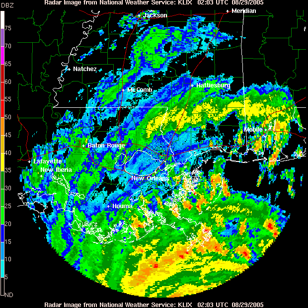
Hurricane Katrina remains a powerful Category 5 hurricane -- top winds are 160 mph. Katrina is a large hurricane with hurricane-force winds extending 105 miles from the center and tropical storm-force winds extending up to 230 miles from the center. Katrina continues to move towards the north-northwest at 10 mph with a turn to the north expected tonight. As of 1:00 a.m. CDT, winds have gusted as high as 101 mph in Southwest Pass, La. which located in the extreme southeastern tip of state. In New Orleans, the lake front observation has reported wind gusts over 60 mph.
The pressure dropped as low as 902 mb this afternoon but has risen to 908 mb as of 12 p.m. CDT. The 902 mb pressure reading was the 4th lowest on record in the Atlantic Basin. Stu Ostro explains the significance of pressure from his blog posted earlier today..."We look at pressures as a good barometer (pun intended) for intensity. The difference in pressure from one location to another, known as the pressure gradient, is associated with wind speed. There are other factors involved, but basically, the greater the pressure gradient in hurricanes, typically the higher the wind speed."
Everyone along the northern Gulf of Mexico should listen to local emergency management officials for instructions. Hurricane warnings are up from Morgan City, La., to the Florida-Alabama border. This includes the city of New Orleans and Lake Pontchartrain. A tropical storm warning and a hurricane watch have been issued from the Alabama-Florida border eastward to Destin, Florida and from west of Morgan City to Intracoastal City, Louisiana.
Although conditions are already deteriorating tonight, places such as New Orleans, La. and Biloxi, Miss. can expect to see the maximum impacts from Katrina on Monday morning and afternoon. Areas further inland such as Meridian, Miss. and Jackson, Miss. should see their maximum impacts by mid-afternoon and through the evening on Monday.
A storm surge of 20 to 25 feet or more is possible along and to the east of Katrina's landfall point Monday. On top of the water rise, pounding waves of 20 to 40 feet will produce catastrophic damage at coastal locations.
Effects from Katrina will not be confined to coastal areas. Once Hurricane Katrina makes landfall, it will progress inland Monday into Tuesday with a trail of flooding rains and damaging winds across Mississippi and Alabama and then into Tennessee. Torrential, flooding rainfall is possible with the remnants of Katrina well inland, possibly into the Ohio Valley, Great Lakes and the Northeast later this week.
Elsewhere, there are two areas of low pressure in the central Atlantic. The first area of low pressure became Tropical Depression Thirteen at 5 p.m. EDT on Sunday. Currently, it is located about 875 miles east of the Lesser Antilles and is expected to pass well north of the islands.
The other area of interest is a low pressure system that has just come off the African coast. This system also has the potential to develop into a tropical depression over the next couple of days.
In the northwest Pacific Talim has become a typhoon and is forecast to grow to a 120 mph typhoon before moving across Taiwan and into mainland China in the next 3 to 4 days.
Hij heeft wel gelijk m.b.t. tot orkanen in het Noord-Atlantische gebied die met categorie 5 AAN LAND komen.quote:Op maandag 29 augustus 2005 07:40 schreef Drugshond het volgende:
dit jaar waren er al 2 CAT 5 tornado's.
Tapai nog niet eens zo heel lang geleden
En nu deze rakker.
Wat ook niet zo handig is dat er een topic in Wetenschap is die nu eigenlijk op dezelfde informatie / soort posts uitdraait: Tropical Cyclone Season 2005quote:Op maandag 29 augustus 2005 08:16 schreef Frutsel het volgende:
nog geen modje die de topictitel wijzigd>?
Er wordt gezegd dat de storm nu krachtiger is dan Andrew uit 1992 die voor 31 miljard dollar schade aanrichtte
Volgens CNN wat ik net heb zitten kijken over een uur of 4 a 5, ietses eerder dusquote:Op maandag 29 augustus 2005 08:56 schreef Frutsel het volgende:
volgens de radio hier, komt de storm om 17.00 uur aan land....Nederlandse tijd dus
Lurf is the message and the message is Lurf
Bekijk eens "Worst case scenario" onder deze CNN pagina.
De enigste protectie die ze hebben is een floodwall tegen een gemiddelde storm.
En nu komt er een CAT-5 beestje aanzetten.
De beste prognose is dat New Orleans zeker nog 120 dagen onder water zal blijven staan. Want alle waterpompen zullen bij een ramp niet meer werken (omdat deze ook onder water staan).
No food, no clean water, no electricity
quote:Bron : CNN Weather
Floodwaters from the east will carry toxic waste from the "Industrial Canal" area, nicknamed after the chemical plants there. From the west, floodwaters would flow through the Norco Destrehan Industrial Complex, which includes refineries and chemical plants, said van Heerden, who has studied computer models about the impact of a strong hurricane for four years.
"These chemical plants are going to start flying apart, just as the other buildings do," he predicted. "So, we have the potential for release of benzene, hydrochloric acid, chlorine and so on."
That could result in severe air and water pollution, he said.
In New Orleans, which lies below sea level, gas and diesel tanks are all located above ground for the same reason that bodies are buried above ground. In the event of a flood, "those tanks will start to float, shear their couplings, and we'll have the release of these rather volatile compounds," van Heerden added.
Because gasoline floats on water, "we could end up with some pretty severe and large -- area-wise -- fires."
"So, we're looking at a bowl full of highly contaminated water with contaminated air flowing around and, literally, very few places for anybody to go where they'll be safe."
vijf meter water in de stad
hoe zit dat met die superdome dan? staat die hoog en droog?
En wanneer veranderen de modjes de topic titel in : [hurricane season 2005] Killer Katrina op ramkoers met New Orleans
hoe zit dat met die superdome dan? staat die hoog en droog?
En wanneer veranderen de modjes de topic titel in : [hurricane season 2005] Killer Katrina op ramkoers met New Orleans


Alsjeblieft.quote:Op maandag 29 augustus 2005 09:29 schreef Frutsel het volgende:
vijf meter water in de stad
hoe zit dat met die superdome dan? staat die hoog en droog?
En wanneer veranderen de modjes de topic titel in : [hurricane season 2005] Killer Katrina op ramkoers met New Orleans
Allah Al Watan Al Malik
Oeiquote:Op maandag 29 augustus 2005 09:35 schreef Roel_Jewel het volgende:
[afbeelding][afbeelding]
Hoogte van de golven .
Hoe laat (onze tijd) is dat ding van plan de kust te raken? Kan het op teletekst niet vinden.
[b]Op dinsdag 4 maart 2008 13:44 schreef Zhenar het volgende:[/b]
Spelletjeshater! :( Prinses der Duisternis! :r Eter van kinderen en puppies!!!!! :'( !!!!!
Spelletjeshater! :( Prinses der Duisternis! :r Eter van kinderen en puppies!!!!! :'( !!!!!
tussen 15.00 en 17.00 uur geht es los...quote:Op maandag 29 augustus 2005 09:48 schreef XcUZ_Me het volgende:
[..]
Oei
Hoe laat (onze tijd) is dat ding van plan de kust te raken? Kan het op teletekst niet vinden.
-dubbel-quote:Op maandag 29 augustus 2005 09:51 schreef Frutsel het volgende:
[..]
tussen 15.00 en 17.00 uur geht es los...
gvd het forum gaat alweer op zn bek
[b]Op dinsdag 4 maart 2008 13:44 schreef Zhenar het volgende:[/b]
Spelletjeshater! :( Prinses der Duisternis! :r Eter van kinderen en puppies!!!!! :'( !!!!!
Spelletjeshater! :( Prinses der Duisternis! :r Eter van kinderen en puppies!!!!! :'( !!!!!
Ok, ga ik me dan even vastkluisteren aan CNN, voor zover dat nut heeft. Thnx!quote:Op maandag 29 augustus 2005 09:51 schreef Frutsel het volgende:
[..]
tussen 15.00 en 17.00 uur geht es los...
[b]Op dinsdag 4 maart 2008 13:44 schreef Zhenar het volgende:[/b]
Spelletjeshater! :( Prinses der Duisternis! :r Eter van kinderen en puppies!!!!! :'( !!!!!
Spelletjeshater! :( Prinses der Duisternis! :r Eter van kinderen en puppies!!!!! :'( !!!!!
Ok.. Zou het zin hebben om CNN te kijken?quote:Op maandag 29 augustus 2005 10:01 schreef Gijsje het volgende:
tussen 4 en 5 uur wordt nu geroepen.
Raar idee eigenlijk, hier is het het mooiste weer van de wereld en daar dreigt een hele stad verzwolgen te worden. Bizar.
[b]Op dinsdag 4 maart 2008 13:44 schreef Zhenar het volgende:[/b]
Spelletjeshater! :( Prinses der Duisternis! :r Eter van kinderen en puppies!!!!! :'( !!!!!
Spelletjeshater! :( Prinses der Duisternis! :r Eter van kinderen en puppies!!!!! :'( !!!!!
zal me benieuwen tot hoe lang de webcams in de lucht zijn en of er echt livebeelden komen
helaas zit ik op het werk tot half 5 en kan ik geen live-beelden/video zien hier
helaas zit ik op het werk tot half 5 en kan ik geen live-beelden/video zien hier
Ik dacht eerst waarom gaan al die mensen, die achterblijven naar die Superdome? Stel dat dat ding helemaal in elkaar dondert. Maar dat ding is dus een en al massief beton waar geen water bij kan komen?
<a href="https://www.youtube.com/watch?v=yIl_jGh-LWE" target="_blank" rel="nofollow">Afleidingsmanoeuvre</a>
blijft zowiezo vreemd dat wij al schreeuwen bij windkracht 10 (windkracht 12 is ca 130 km/u) en zij daar met het dubbele te maken hebben...
zouden onze bakstenen huizen dat overleven?
zouden onze bakstenen huizen dat overleven?
http://news.bbc.co.uk/2/hi/americas/4192218.stmquote:Although the storm has been downgraded from category five to four, forecasters predict it could strengthen again as it hits land at about sunrise (1100 GMT).
rond 1 uur Nederlandse tijd raakt ie de kust zelf
New Orleans ligt iets verder landinwaarts, dat wordt een paar uur later geraakt
Ik hoop dat ik daar nooit achter hoef te komen eerlijk gezegd...quote:Op maandag 29 augustus 2005 10:07 schreef Frutsel het volgende:
blijft zowiezo vreemd dat wij al schreeuwen bij windkracht 10 (windkracht 12 is ca 130 km/u) en zij daar met het dubbele te maken hebben...
zouden onze bakstenen huizen dat overleven?
[b]Op dinsdag 4 maart 2008 13:44 schreef Zhenar het volgende:[/b]
Spelletjeshater! :( Prinses der Duisternis! :r Eter van kinderen en puppies!!!!! :'( !!!!!
Spelletjeshater! :( Prinses der Duisternis! :r Eter van kinderen en puppies!!!!! :'( !!!!!
Ik denk het niet, kijk maar naar Engeland begin deze maand die windhoos liet ook niet veel over van die stad. Weet even niet welke.quote:Op maandag 29 augustus 2005 10:07 schreef Frutsel het volgende:
blijft zowiezo vreemd dat wij al schreeuwen bij windkracht 10 (windkracht 12 is ca 130 km/u) en zij daar met het dubbele te maken hebben...
zouden onze bakstenen huizen dat overleven?
-
Het schijnt dat snelwegen nu ook éénrichtingsverkeer zijn geworden, om de doorstroming zo veel te bevorderen. Wie zou er nu ook natuurlijk naar New Orleans willen rijden.
<a href="https://www.youtube.com/watch?v=yIl_jGh-LWE" target="_blank" rel="nofollow">Afleidingsmanoeuvre</a>
http://www.theglobeandmai(...)rnational/TopStoriesquote:....
When Hurricane Katrina hits today, it could turn one of the United State's most charming cities into a vast cesspool tainted with toxic chemicals, human waste and even coffins released by floodwaters form the city's legendary cemeteries. In the French Quarter, the water could reach seven metres, easily submerged the district's iconic cast-iron balconies and bars.
...
http://www.indystar.com/a(...)829/NEWS06/508290407quote:...
Experts also have warned that the ring of high levees around New Orleans, designed to protect the city from floodwaters coming down the Mississippi, will only make things worse in a powerful hurricane. Katrina is expected to push a 28-foot storm surge against the levees. Even if they hold, water will pour over their tops and begin filling the city as if it were a sinking canoe.
After the storm passes, the water will have nowhere to go.
In a few days, van Heerden predicts, emergency management officials are going to be wondering how to handle a giant stagnant pond contaminated with building debris, coffins, sewage and other hazardous materials.
"We're talking about an incredible environmental disaster," van Heerden said.
...
[ Bericht 43% gewijzigd door zakjapannertje op 29-08-2005 11:28:17 ]
Birmingham.quote:Op maandag 29 augustus 2005 10:09 schreef Gijsje het volgende:
[..]
Ik denk het niet, kijk maar naar Engeland begin deze maand die windhoos liet ook niet veel over van die stad. Weet even niet welke.
2 dolfijnen in een hotelzwembad zij werden ook geevacueerd, het chloorgehalte werd iets verlaagd voor de dolfijnen, voor een paar dagen ofzo kon dit geen kwaad zei een dolfijnhoudster
Wat een ontkennende smileyquote:Op maandag 29 augustus 2005 11:50 schreef Eveli het volgende:
Ik ga vanmiddag heel wat uurtjes voor de TV doorbrengen denk ik.....
O, ye Fountains, Meadows, Hills, and Groves
http://www.wetteronline.de/cgi-bin/sturmframe?LANG=de&GEBIET=atl&STURM=katrina&JJ=xxxx&MM=08&TT=26&ART=txt
Om 11 uur:
druk 915 hPa
gemiddeld 241 km/u
uitschieters tot 296 km/u
Om 11 uur:
druk 915 hPa
gemiddeld 241 km/u
uitschieters tot 296 km/u
Die hebben we 10 jaar terug gehad in nederland en de huizen hielden het redelijk, behalve wat pannen viel het mee. In de VS zijn de huizen over het algemeen wat minder stevig heb ik het idee.quote:Op maandag 29 augustus 2005 10:09 schreef XcUZ_Me het volgende:
[..]
Ik hoop dat ik daar nooit achter hoef te komen eerlijk gezegd...
🕰️₿🕰️₿🕰️₿🕰️₿🕰️₿🕰️ TikTok next Block
Lijkt toch niet direct over New Orleans te komen...
quote:Although New Orleans was braced for a direct hit, experts suggested Monday that that coastal Mississippi may bear the brunt of the storm, although New Orleans would certainly be affected.
Is moeilijk te vergelijken hoor. Ik denk dat je doelt op de orkaan van 1990, maar die zou maar in categorie I komen in de schaal die in Amerika gehanteerd wordt.quote:Op maandag 29 augustus 2005 13:40 schreef raptorix het volgende:
[..]
Die hebben we 10 jaar terug gehad in nederland en de huizen hielden het redelijk, behalve wat pannen viel het mee. In de VS zijn de huizen over het algemeen wat minder stevig heb ik het idee.
Van het KNMI:
Deze snelheden zijn tientallen kilometers per uur lager dan die nu bij Katrina gemeten worden.quote:IJmuiden registreerde gedurende minstens een uur windkracht 11, een zeer zware storm met gemiddelde windsnelheden tussen 103 en 117 km/h. Ronduit uniek waren de windstoten van 150 km/h op verschillende plaatsen tot maximaal 161 km/h op een van de windmeters van Schiphol. Dergelijke windstoten horen tot de hoogst mogelijke in ons land; de zwaarste windstoot in honderd jaar die tijdens een storm is gemeten staat op naam van Hoek van Holland waar de meter op 6 november 1921 tot 162 km/h uitschoot. Op 28 december 2001 werd die windsnelheid in IJmuiden bijna weer bereikt, toen hier 158 km/h werd gemeten.
<a href="https://www.youtube.com/watch?v=yIl_jGh-LWE" target="_blank" rel="nofollow">Afleidingsmanoeuvre</a>
Kun je nagaan, die bijna 250 km/u is slechts een gemiddelde snelheid. Hier in Nederland zijn zelfs nog nooit uitschieters van die snelheid gemeten! Kun je nagaan wat er gebeurt als er een constante wind van ver over de 200 km/u op het land beukt. Dat is echt haast niet te bevatten. Daarmee vergeleken zijn onze stormen slechts een fris briesje.quote:Op maandag 29 augustus 2005 13:54 schreef Falco het volgende:
Deze snelheden zijn tientallen kilometers per uur lager dan die nu bij Katrina gemeten worden.
Gelukkig raakt ie , zoals gisteren wel verwacht, downtown New Orleans niet.
Ziet er beter uit dan gisteren.
Ziet er beter uit dan gisteren.
Patience is not one of my virtues, neither is memory. Or patience for that matter.
Reken maar wel dat ze wel veel schade ondervinden. De orkaan heeft nu die Missisipi-delta onder New Orleans bereikt. Over een uur of vier zal die dan wel in New Orleans zijn geloof ik.quote:Op maandag 29 augustus 2005 14:11 schreef popolon het volgende:
Gelukkig raakt ie , zoals gisteren wel verwacht, downtown New Orleans niet.
Ziet er beter uit dan gisteren.
<a href="https://www.youtube.com/watch?v=yIl_jGh-LWE" target="_blank" rel="nofollow">Afleidingsmanoeuvre</a>
Zo super is die Superdome nu ook niet meer. Het dak lekt, en ze hebben het erover dat er sommige delen van het dak nu zelfs los zitten, aldus CNN.
Ja dat begrijp ik.quote:Op maandag 29 augustus 2005 14:58 schreef Falco het volgende:
[..]
Reken maar wel dat ze wel veel schade ondervinden. De orkaan heeft nu die Missisipi-delta onder New Orleans bereikt. Over een uur of vier zal die dan wel in New Orleans zijn geloof ik.
Het ging me even over 'het oog' van de orkaan.
Patience is not one of my virtues, neither is memory. Or patience for that matter.
Komt 'ie niet. CNN weerman denkt dat het ongeveer nog een uur duurt voordat hij het dichstbij New Orleans is.quote:Op maandag 29 augustus 2005 14:28 schreef Vizual het volgende:
hoe laat gaat die orkaan new orleans bereiken
Fuck zeg... op CNN werd (volgens RTLZ) gemeld dat een deel van het dak van de Superdome zou zijn gesneuveld....
Ah de orkaan heeft New Orleans nu al bereikt, maar het ergste zal nog wel moeten komen...
<a href="https://www.youtube.com/watch?v=yIl_jGh-LWE" target="_blank" rel="nofollow">Afleidingsmanoeuvre</a>
quote:BREAKING NEWS Report: Roof of Superdome in New Orleans, where thousands evacuated ahead of Hurricane Katrina, is leaking rain. Details soon.


Hoe dan ook, dat wordt een enorme bende van drek en rotzooi.
Wie bouwt er dan ook een stad op een moeras.
Wie bouwt er dan ook een stad op een moeras.
Patience is not one of my virtues, neither is memory. Or patience for that matter.
Ik weet nou niet of ik hoop op een echte gigantische ramp of niet
Wel ejn beetje sneu dat het dak nu al lekt
Edit: Ook wel aardig om te zien welke verslaggever het langst blijft verslag-geven
[ Bericht 27% gewijzigd door #ANONIEM op 29-08-2005 15:16:55 ]
Wel ejn beetje sneu dat het dak nu al lekt
Edit: Ook wel aardig om te zien welke verslaggever het langst blijft verslag-geven
[ Bericht 27% gewijzigd door #ANONIEM op 29-08-2005 15:16:55 ]

Zit je daar dan te wachten tot je door het oog van Katrina wordt opgezogen...quote:CNN news: the roof of the superdome is starting to peel off!
How do you get precisely 4 Gallons of water with a 3 Gallon and 5 Gallon Can...
quote:Op maandag 29 augustus 2005 15:16 schreef Tobbes het volgende:
Ik weet nou niet of ik hoop op een echte gigantische ramp of niet
"Whatever the mind of man can conceive and believe, it can achieve" Napoleon Hill
Ja ik bedoel; het is wel sensatie enzo; en laten nou juist de Amerikanen sensatiebelust zijn...quote:
popcorn, cola erbij en genieten maar..quote:Op maandag 29 augustus 2005 15:22 schreef Tobbes het volgende:
[..]
Ja ik bedoel; het is wel sensatie enzo; en laten nou juist de Amerikanen sensatiebelust zijn...
"Whatever the mind of man can conceive and believe, it can achieve" Napoleon Hill
Zouden ze in de dome nog een nummer van Katrina & the Waves draaien om de gemoederen een beetje te sussen..
How do you get precisely 4 Gallons of water with a 3 Gallon and 5 Gallon Can...
Alle webcams in New Orleans zijn onbereikbaar of doen het niet .
<a href="https://www.youtube.com/watch?v=yIl_jGh-LWE" target="_blank" rel="nofollow">Afleidingsmanoeuvre</a>
Tja, als ze de stroom hebben uitgeschakeld...quote:Op maandag 29 augustus 2005 15:28 schreef Falco het volgende:
Alle webcams in New Orleans zijn onbereikbaar of doen het niet .
How do you get precisely 4 Gallons of water with a 3 Gallon and 5 Gallon Can...
Of: 'Gone with the wind'quote:Op maandag 29 augustus 2005 15:27 schreef Mr.Noodle het volgende:
Zouden ze in de dome nog een nummer van Katrina & the Waves draaien om de gemoederen een beetje te sussen..
Nu meldt CNN dat de nationale garde bezig om mensen te verplaatsen die onder het dak zitten van de dome.

Ik dacht ook gehoord te hebben dat sowieso het veld van die Superdome wel eens onder water zou kunnen komen te staan, klopt dat?
Mooi genaaid als je daar staat dan , aan de onderkant loopt de dome als een badkuip vol en op de hogere regionen krijg je een stofzuiger in je nek met als je geluk hebt een gratis vlieguurtje erbij..
How do you get precisely 4 Gallons of water with a 3 Gallon and 5 Gallon Can...
De mensen zitten op de tribunes.quote:Op maandag 29 augustus 2005 15:32 schreef Monidique het volgende:
Ik dacht ook gehoord te hebben dat sowieso het veld van die Superdome wel eens onder water zou kunnen komen te staan, klopt dat?
🕰️₿🕰️₿🕰️₿🕰️₿🕰️₿🕰️ TikTok next Block
ligt eraan.. 9 meter water valt niet uit de lucht... als de zijkanten van de Dome goed beschermd zijn kan de Stormsurge of het rivierwater er niet in dringen lijkt me
Dat weet ik, maar hoewel het ongetwijfeld een mooi Romeins spektakel zal opleveren, lijkt het mij niet echt geruststellend wanneer het water binnen begint te komen, ook al zit daar wel veilig. Zonder airconditioning, trouwens.quote:Op maandag 29 augustus 2005 15:41 schreef raptorix het volgende:
[..]
De mensen zitten op de tribunes.
De deuren zullen toch niet waterdicht zijn?quote:Op maandag 29 augustus 2005 15:43 schreef Frutsel het volgende:
ligt eraan.. 9 meter water valt niet uit de lucht... als de zijkanten van de Dome goed beschermd zijn kan de Stormsurge of het rivierwater er niet in dringen lijkt me
Dat dak van de superdome was geloof ik ook weer lekker van zeil gemaakt..
How do you get precisely 4 Gallons of water with a 3 Gallon and 5 Gallon Can...

New Orleans, braced for a catastrophic direct hit from the powerful Category 4 storm, hunkered nearly 10,000 people in its mammoth Superdome, but Ed Reams of CNN affiliate WDSU reported that the structure has begun leaking as the winds damaged the roof letting daylight and rainwater in the darkened arena.
"I can see daylight straight up from inside the Superdome," Reams reported.
National Guard troops moved people to the other side of the dome. Others were moving beneath the concrete-reinforced terrace level.
"This is only going to get bigger," he said. "We have another two hours before the worst of the storm gets to us."
CNN
Galgenhumor.quote:Op maandag 29 augustus 2005 15:27 schreef Mr.Noodle het volgende:
Zouden ze in de dome nog een nummer van Katrina & the Waves draaien om de gemoederen een beetje te sussen..
New Orleans is sinking (and i don't want to swim) van The Tragically Hip is ook een optie.
J.
You bend your words like Uri Geller spoons...

Ik had er idd, ook een andere smiley voor moeten neerzettenquote:Op maandag 29 augustus 2005 15:50 schreef Juan Zueco het volgende:
[..]
Galgenhumor.
New Orleans is sinking (and i don't want to swim) van The Tragically Hip is ook een optie.
J.
How do you get precisely 4 Gallons of water with a 3 Gallon and 5 Gallon Can...
Atlanta?
Ik denk dat het allemaal wel mee gaat vallen. Dat Katrina langs New Orleans gaat en niet al teveel schade daar aanricht... (minder dan verwacht). En ik heb er geld opgezet, dus nu maar hopen op een goede afloop
Ik denk dat het allemaal wel mee gaat vallen. Dat Katrina langs New Orleans gaat en niet al teveel schade daar aanricht... (minder dan verwacht). En ik heb er geld opgezet, dus nu maar hopen op een goede afloop

Duketape !!!quote:Op maandag 29 augustus 2005 15:44 schreef Tobbes het volgende:
Waarom waait het petje van die goze niet weg.
Nog veel licht voor een stad waar de stroom is uitgevallen. of is dit 's nachts (want 't lijkt verder wel heel donker).quote:
New Orleans * maa 09:04quote:Op maandag 29 augustus 2005 15:59 schreef Roel_Jewel het volgende:
[..]
Nog veel licht voor een stad waar de stroom is uitgevallen. of is dit 's nachts (want 't lijkt verder wel heel donker).
Uiteraard, doen die mensen het ook in hun broek...quote:Op maandag 29 augustus 2005 16:19 schreef LuukBes het volgende:
Lol @ CNN dramareporters ter plekke.
How do you get precisely 4 Gallons of water with a 3 Gallon and 5 Gallon Can...
Jammer, geen tv tot m'n beschikking nuquote:Op maandag 29 augustus 2005 16:19 schreef LuukBes het volgende:
Lol @ CNN dramareporters ter plekke.
Lekkere dramatiek. Klapperende wangen-gezichten die in de storm kijken, rondvliegende rotzooi en een reporter die naast een hotel staat dat lanzgaamaan afgebroken wordt en waar het dak loslaat.
Only on CNN. Will be back after the break, with more Breaking News.
Only on CNN. Will be back after the break, with more Breaking News.
A LEVEE BREACH OCCURRED ALONG THE INDUSTRIAL CANAL AT TENNESSE STREET. 3 TO 8 FEET OF WATER IS EXPECTED DUE TO THE BREACH...LOCATIONS IN THE WARNING INCLUDE BUT ARE NOT LIMITED TO ARABI AND 9TH WARD OF NEW ORLEANS.
St. Bernard Parish spokesman Larry Ingargiola says the parish's two shelters at Chalmette High and St. Bernard High are suffering major damage. He said Chalmette High shelter is losing its roof, and St. Bernard High has plenty of broken windows and glass. He estimates 300-plus refugees at the two sites.
Entergy says 317,000 customers were without power as of 6 a.m. Cleco reported 40,000 without power in St. Tammany Parish.
St. Bernard Parish officials say most of the parish has no power.
🕰️₿🕰️₿🕰️₿🕰️₿🕰️₿🕰️ TikTok next Block
Het blijft een entertainment-news-channel he...quote:Op maandag 29 augustus 2005 16:23 schreef LuukBes het volgende:
Lekkere dramatiek. Klapperende wangen-gezichten die in de storm kijken, rondvliegende rotzooi en een reporter die naast een hotel staat dat lanzgaamaan afgebroken wordt en waar het dak loslaat.
Only on CNN. Will be back after the break, with more Breaking News.
niet daargelaten dat de situatie ernstig blijft natuurlijk..
Leedvermaak verkoopt het beste.quote:Op maandag 29 augustus 2005 16:26 schreef Kjew het volgende:
[..]
Het blijft een entertainment-news-channel he...
niet daargelaten dat de situatie ernstig blijft natuurlijk..
Chips en popcorn erbij, lekker op de sofa chillen op natuurgeweld en andersmans ellende.
"We should have signed the Kyoto protocol. We're being fucked by nature. "
die superdome is boven de zeespiegel gebouwd dus dat ding kan haast niet overstromen alleen wel alles erom heen. dus dan zitten zei als ware up hun eigen eiland..
Katrina pikt droge lucht op.
Ze wordt een stuk minder krachtig volgens Weather Channel.
Ze wordt een stuk minder krachtig volgens Weather Channel.
Patience is not one of my virtues, neither is memory. Or patience for that matter.
Het lijkt er dus vooralsnog op dat het vooral materiële schade zal zijn? If so: gelukkig maar!
[b]Op dinsdag 4 maart 2008 13:44 schreef Zhenar het volgende:[/b]
Spelletjeshater! :( Prinses der Duisternis! :r Eter van kinderen en puppies!!!!! :'( !!!!!
Spelletjeshater! :( Prinses der Duisternis! :r Eter van kinderen en puppies!!!!! :'( !!!!!
understatement van de anchorman:
"Be carefull there's a lot of stuff flying around"
Zei hij tegen de reporter die bijna wegwaait en verdrinkt in een wolk
"Be carefull there's a lot of stuff flying around"
Zei hij tegen de reporter die bijna wegwaait en verdrinkt in een wolk
"We now even have a victim in the hotel. A woman's finger was cut in half becasue a door slammed shut when the wind in the hotel picked up. Teh Drama, teh horror."
Back to Chad Myers now, in Hurricane Headquarters.
Back to Chad Myers now, in Hurricane Headquarters.
hurricanes bedoel je.quote:Op maandag 29 augustus 2005 07:40 schreef Drugshond het volgende:
dit jaar waren er al 2 CAT 5 tornado's.
Tapai nog niet eens zo heel lang geleden
En nu deze rakker.
ik had moeten zeggen 3 CAT 5 hurricanes sinds 1850 in de VS.
Dostojewski: "Je kunt je niet van je eigen gezond verstand overtuigen door je buurman op te sluiten."


http://edition.cnn.com/20(...)e.katrina/index.html
quote:Hurricane Katrina weakened slightly as it pummeled the Gulf Coast Monday, but the powerful storm still had plenty of punch as it swept through Mississippi with maximum sustained winds of 95 mph.
The weather service reported that "extensive and life-threatening storm surge flooding" was occurring along the Louisiana and Mississippi coast.
Mississippi Gov. Haley Barbour told reporters that Katrina "came in on Mississippi like a ton of bricks."
When asked what was his greatest fear, Barbour replied grimly "that there are a lot of dead people down there."
Inderdaad een mooi animatiefilmpjequote:Op maandag 29 augustus 2005 23:24 schreef Roel_Jewel het volgende:
http://news.bbc.co.uk/2/hi/science/nature/4588149.stm
mooie animatie over het ontstaan van orkanen


Stelende schoften. dxxdschieten. Alleen al daarom zou ik de stad en mijn eigendommen niet verlaten.


"Welfare culture is bad not just because, as in Europe, it's bankrupting the state, but because it enfeebles the citizenry, it erodes self-reliance and resourcefulness."
-Mark Steyn
-Mark Steyn

Dostojewski: "Je kunt je niet van je eigen gezond verstand overtuigen door je buurman op te sluiten."
Jammer voor de onschuldige inwoners, maar ik gun het Bush wel: de financiële malaise en de stress.
²
²
Misgun niemand zijn profijt, laat elk op hoope bouwe. Ofschoon wie mij ook benijdt, fortuin moet zijn loop behouden.
Bansheeboy: Fok!ker van de week!
[Without heart we would be mere machines]
Bergkamp, Zlatan, Van Persie, Ziyech, Quaresma
Bansheeboy: Fok!ker van de week!
[Without heart we would be mere machines]
Bergkamp, Zlatan, Van Persie, Ziyech, Quaresma
Ik denk ook dat Bush er veel van merkt in Washington...
Trouwens 30 doden in 1 appartementen complex
Trouwens 30 doden in 1 appartementen complex
denk je nou echt dat hij er een halve minuut minder om slaapt?quote:Op dinsdag 30 augustus 2005 07:58 schreef BansheeBoy het volgende:
Jammer voor de onschuldige inwoners, maar ik gun het Bush wel: de financiële malaise en de stress.
²
Wat kan hij aan een natuurfenomeen doen... hij wordt alleen maar meer een held om de opvang goed te gaan regelen...
Beetje overtrokken om hier bush weer bij te halen, typerend...
***************************************quote:Op dinsdag 30 augustus 2005 08:25 schreef Mutant01 het volgende:
Er zijn 56 doden op dit moment.
Zeker 55 doden door orkaan Katrina
***************************************
NEW ORLEANS De orkaan Katrina heeft in
het zuiden van de VS het leven gekost
aan zeker 55 mensen.Vooral in de stad
Biloxi waar een flatgebouw is ingestort
zijn veel slachtoffers.Grote delen van
Mississippi,Louisiana en Alabama staan
onder water.Zeker 1,3 miljoen mensen
zitten zonder stroom.Het kan weken
duren voordat dat overal hersteld is.
De schade is groot,maar in New Orleans
was de orkaan minder verwoestend dan
gevreesd.Dat komt omdat Katrina op het
laatste moment wat afboog.
De totale schade wordt geschat op zeker
10 miljard dollar,maar kan oplopen tot
26 miljard,waarschuwen verzekeraars.
***************************************
Dan loopt de nos 1 dooie achter
Lurf is the message and the message is Lurf
volgens de laatste berichten is er een soort dijk doorgebroken en stijgt het water met een inch elke 5 minuten in new orleans, wat onder de zeespiegel ligt.. een ziekenhuis staat op het punt te evacueren voordat het water de tweede etage bereikt waar de noodstroom voorzieningen staan ..
bron CNN..
dodental gaat ook nog wel flink oplopen hoor, je krijgt nog uitbraken van epidemieen ( cholera enzo door het rioolwater
bron CNN..
dodental gaat ook nog wel flink oplopen hoor, je krijgt nog uitbraken van epidemieen ( cholera enzo door het rioolwater
Zij die willen voorkomen dat je de werkelijke geschiedenis kent, zijn er op uit hem te herhalen.
Do not attempt to think or depression may occur, All sports broadcasts will proceed as normal
Do not attempt to think or depression may occur, All sports broadcasts will proceed as normal
Zo ver komt het niet. Het zijn hier niet overstromingen met India-toestanden.quote:dodental gaat ook nog wel flink oplopen hoor, je krijgt nog uitbraken van epidemieen ( cholera enzo door het rioolwater
''All residents of Jefferson Parish are under a boil order.''
''Boil water order in effect for New Orleans, except for Algiers and the CBD, due to a water main break.''
''Entergy says 700,000 customers without power; Cleco says 70,000 have no power.''
nou maar hopen dat ze niet op electriciteit koken, als ze al teruggekeerd zijn
''Boil water order in effect for New Orleans, except for Algiers and the CBD, due to a water main break.''
''Entergy says 700,000 customers without power; Cleco says 70,000 have no power.''
nou maar hopen dat ze niet op electriciteit koken, als ze al teruggekeerd zijn


There iswas a house in New Orleans
They call the Rising Sun Water
It's been the ruin of many a poor girl
And me, Oh Lord! was one
My mother was a tsailor,
She sewedsailed the new blue jeansstreets.
My lover he was a gamblerdrinker, Oh Lord,
Gambleddrunk down in New Orleans.
[ Bericht 2% gewijzigd door #ANONIEM op 30-08-2005 11:06:45 ]

Nederlands Journaal loopt te slapen zeg. Wakker worden !
Er is een dijk doorgebroken en nu staat 80 % van de stad onder water !!!
En er zijn veel meer dan 50 doden.
Er is een dijk doorgebroken en nu staat 80 % van de stad onder water !!!
En er zijn veel meer dan 50 doden.
Zo zie je maar dat Toorn van God wel degelijk straft. De VS heeft jaren zo niet eeuwenlang andere volkeren uitgebuit, systematisch ideologisch vernederd, en rantsoenen ingeslagen.
Ik vind het wel jammer voor de onschuldige mensen, maar wat de regering Bush betreft kan ik alleen maar blij zijn als zij lijden onder natuurrampen als deze.
²
[ Bericht 2% gewijzigd door BansheeBoy op 30-08-2005 13:03:08 (Nutella aangevuld...) ]
Ik vind het wel jammer voor de onschuldige mensen, maar wat de regering Bush betreft kan ik alleen maar blij zijn als zij lijden onder natuurrampen als deze.
²
[ Bericht 2% gewijzigd door BansheeBoy op 30-08-2005 13:03:08 (Nutella aangevuld...) ]
Misgun niemand zijn profijt, laat elk op hoope bouwe. Ofschoon wie mij ook benijdt, fortuin moet zijn loop behouden.
Bansheeboy: Fok!ker van de week!
[Without heart we would be mere machines]
Bergkamp, Zlatan, Van Persie, Ziyech, Quaresma
Bansheeboy: Fok!ker van de week!
[Without heart we would be mere machines]
Bergkamp, Zlatan, Van Persie, Ziyech, Quaresma
Nee hoor, dit is gewoon de natuur.quote:Op dinsdag 30 augustus 2005 13:02 schreef BansheeBoy het volgende:
Zo zie je maar dat Toorn van God wel degelijk straft. De VS heeft jaren zo niet eeuwenlang andere volkeren uitgebuit, systematisch ideologisch vernederd, en rantsoenen ingeslagen.
Ik vind het wel jammer voor de onschuldige mensen, maar wat de regering Bush betreft kan ik alleen maar blij zijn als zij lijden onder natuurrampen als deze.
²
quote:505 Teletekst di 30 aug
***************************************
Opluchting over afzwakken Katrina
***************************************
NEW YORK Opluchting over het afzwakken
van de orkaan Katrina heeft Wall Street
op winst gezet.De Dow-Jonesindex sloot
0,63 procent hoger op 10.463,05 en de
Nasdaq 0,8 procent hoger op 2137,65.
Doe-het-zelfketen Home Depot won 1,7%.
Beleggers verwachten dat Katrina veel
kluswerk oplevert.De oliesector was
verdeeld.De oliefondsen leverden in
toen de olieprijs in de loop der dag
na de forse stijging stevig daalde.
http://www.standaard.be/nieuws/buitenland/index.asp?Snel=1&articleID=DMF30082005_027quote:Vluchtelingen in Superdome mogen even frisse neus halen
12:11:33
NEW ORLEANS - De bewoners van New Orleans die voor de orkaan Katrina schuilden in de plaatselijke Superdome mochten gisteravond even over de boulevard langs het stadion wandelen om een frisse neus te halen. Daarna moesten ze het stadion weer in voor een tweede nacht in de duistere, warme en stinkende ruimte. Volgens een medewerker van het bedrijf dat de Superdome exploiteert, zijn twee mensen overleden. Hij gaf geen nadere toelichting.
Nadat Katrina de elektriciteitsvoorziening onklaar had gemaakt werd het snel warm en benauwd in de Superdome, waar acht tot negenduizend burgers worden opgevangen. De wc’s in het stadion zijn smerig, de vuilnisbakken overvol, er komt nog maar weinig water uit de kraan en op veel plaatsen lekt het dak.
Vooral voor zieken en bejaarden in rolstoelen, die vijf rijen dik langs een muur waren neergezet, was de situatie oncomfortabel. De autoriteiten overwegen de patiënten naar beter uitgeruste opvangcentra over te brengen.
,,O God, frisse lucht, wat heerlijk is dat. Het is de eerste keer vandaag dat ik adem wil halen'', zei de 33-jarige Robin Smith toen ze even buiten mocht. De 29-jarige Shanda Wilson verbaasde zich over de aanblik van haar stad zonder licht. ,,Zo heb ik het nog nooit gezien. Zoveel duisternis heb ik nog nooit gezien.''
De evacuees krijgen in de Superdome twee maaltijden per dag. Sommigen zitten op plastic zitplaatsen, anderen liggen op dekens of handdoeken op de grond. Op de plekken waar noodaggregaten voor licht zorgen, wordt gekaart en gelezen.
Tijdens de orkaan vlogen er twee stukken van het gewelfde dak van het stadion. ,,Toen werd ik zo bang'', zei de 82-jarige Anice Sexton. ,,Verder was het niet zo erg. De mensen zijn zo aardig en de mensen die hier zitten werken echt goed mee. Maar de wc’s zijn verschrikkelijk.''
[ Bericht 58% gewijzigd door zakjapannertje op 30-08-2005 13:34:46 ]
Wat ben je ook een lolbroek.quote:Op dinsdag 30 augustus 2005 13:02 schreef BansheeBoy het volgende:
Zo zie je maar dat Toorn van God wel degelijk straft. De VS heeft jaren zo niet eeuwenlang andere volkeren uitgebuit, systematisch ideologisch vernederd, en rantsoenen ingeslagen.
Ik vind het wel jammer voor de onschuldige mensen, maar wat de regering Bush betreft kan ik alleen maar blij zijn als zij lijden onder natuurrampen als deze.
²
Bij de volgende aarbeving in Istanboel (en die komt er binnen nu en 10 jr) zullen we onze God eens aanbidden.
Wat een puinhoop, niet alleen in NO maar ook de gebieden daarbuiten.
Vooral veel waterschade.
Eigenlijk is heel NO gewoon kapot, zeker voor een aantal maanden.
Vooral veel waterschade.
Eigenlijk is heel NO gewoon kapot, zeker voor een aantal maanden.
Patience is not one of my virtues, neither is memory. Or patience for that matter.
Wakker worden mensen !!!
ingekort van: http://www.weer.nl/indexa.html (meteconsult)
Orkaan Katrina veroorzaakt toch grote watersnoodramp in New Orleans dinsdag 30 augustus 2005
"Al met al leek het erop dat New Orleans door het oog van de naald gekropen was (in dit kader een toepasselijke woordspeling), maar was de schade niettemin enorm. De foto’s bij dit verhaal geven hiervan een duidelijk beeld.
De vorige zin begon bewust met het woord “leek”, want vanochtend Nederlandse tijd is onverwacht de dijk van het meer Pontchartrain, gelegen aan de noordkant van de stad, doorgebroken over een lengte van maar liefst 70 m. Inmiddels is ongeveer 80% van de stad ondergelopen en in de lagere delen van New Orleans is het water inmiddels gestegen tot 7 meter hoogte! Onder ander het Tulane hospitaal ter plekke zal in allerijl moeten worden geëvacueerd. Vanochtend stond het water daar al aan het plafond van de eerste verdieping en steeg nog met 30 cm per uur. Pompen kunnen niet werken, het water stroomde sneller binnen dan het weggepompt kon worden.
Nog meer schade in New Orleans.
Gevreesd wordt dat het hele meer zich zal legen in de kom die New Orleans heet. Een woordvoerder zei het treffend: “We worden nu al omringd door 2 meter water en er komt nog meer hier binnen. Het water stijgt zo snel dat ik niet kan beschrijven hoe snel het stijgt.” Het hospitaal huist ongeveer duizend ernstig zieke mensen, doktoren en verpleegsters, die allemaal door de lucht geëvacueerd moeten worden. Elders in de stad steeg het water soms zo snel dat sommigen niet eens de tijd hadden om hun schoenen aan te trekken, alvorens naar hogere verdiepingen te vluchten.
Het is nu al duidelijk dat Katrina de kostbaarste orkaan uit de Amerikaanse geschiedenis gaat worden. In augustus 1992 eiste Andrew 26.2 miljard dollar schade op, Katrina komt daar zeker boven. Gevreesd moet worden dat de miljoen mensen die New Orleans hebben verlaten, voorlopig niet naar hun huizen kunnen terugkeren. Allereerst zal het gat in de dijk gedicht moeten worden, daarna moet het water weggepompt worden en pas daarna kan men aan het herstellen van de schade gaan denken. Mogelijk zullen honderdduizenden mensen wel een seizoen tot zelfs een half jaar lang van huis en haard verstoken blijven"
Blijft echt bizar.
Als student valt dus een hele hoop weg zoals je school,bijbaantje etc.
Je leven stopt gewoon voor een paar maanden.
Als student valt dus een hele hoop weg zoals je school,bijbaantje etc.
Je leven stopt gewoon voor een paar maanden.
Ja ik snap er echt helemaal niets van! Je leest er niets over op Teletekst, en berichtgeving over Katrina op het Journaal is kort.quote:Op dinsdag 30 augustus 2005 12:33 schreef ondersoeker het volgende:
Nederlands Journaal loopt te slapen zeg. Wakker worden !
Er is een dijk doorgebroken en nu staat 80 % van de stad onder water !!!
En er zijn veel meer dan 50 doden.
Op CNN is het al dagen het belangrijkste (zowat enige) nieuws (en terecht!). Als in Amsterdam een hondje verdrinkt komt het op het nieuws maar als er een hele stad elders in de wereld onder water staat, neuh laat maar zitten
Iets minder dan een half miljoen in de stad zelf, maar in de voorsteden wonen nog eens een kleine miljoen mensen.quote:Op dinsdag 30 augustus 2005 14:44 schreef Orcaman1984 het volgende:
Hoeveel inwoners heeft New Orleans eigenlijk?
600,000 stad. 1.3 miljoen agglomeratie. Net zo groot als Rotterdam.quote:Op dinsdag 30 augustus 2005 14:44 schreef Orcaman1984 het volgende:
Hoeveel inwoners heeft New Orleans eigenlijk?

http://en.wikipedia.org/wiki/New_Orleans#Demographicsquote:Op dinsdag 30 augustus 2005 14:44 schreef Orcaman1984 het volgende:
Hoeveel inwoners heeft New Orleans eigenlijk?
En dat beetje nieuws dàt over de orkaan gaat, heeft 't over het feit dat er weinig toeristen in het gebied zitten. Alsof mij dat ook maar iets interesseert .quote:Op dinsdag 30 augustus 2005 14:44 schreef ItaloDancer het volgende:
[..]
Ja ik snap er echt helemaal niets van! Je leest er niets over op Teletekst, en berichtgeving over Katrina op het Journaal is kort.
Op CNN is het al dagen het belangrijkste (zowat enige) nieuws (en terecht!). Als in Amsterdam een hondje verdrinkt komt het op het nieuws maar als er een hele stad elders in de wereld onder water staat, neuh laat maar zitten
Dus de berichtgeving loopt achter en is matig?
Zag op de NOS site dat 't allemaal meeviel en maar 5 doden te betreuren.
5? Dat zijn er tot nu toe minimaal 50 te weinig.
Zag op de NOS site dat 't allemaal meeviel en maar 5 doden te betreuren.
5? Dat zijn er tot nu toe minimaal 50 te weinig.
Patience is not one of my virtues, neither is memory. Or patience for that matter.
Osama schijnt in 2003 gespot te zijn in een al-cherokee trainingskamp alwaar hij een opleiding regendanser volgde.. dubieus....
Zij die willen voorkomen dat je de werkelijke geschiedenis kent, zijn er op uit hem te herhalen.
Do not attempt to think or depression may occur, All sports broadcasts will proceed as normal
Do not attempt to think or depression may occur, All sports broadcasts will proceed as normal
Toch wel pittig.quote:Katrina treft vooral Biloxi zwaar
***************************************
BILOXI In de stad Biloxi in Missisippi
heeft Katrina waarschijnlijk honderden
levens geëist.De exacte cijfers zijn
nog niet bekend,maar een woordvoerder
zegt dat er meer slachtoffers zijn dan
tijdens de orkaan Camille in 1969.Toen
kwamen er in de stad 256 mensen om.
In New Orleans wordt eveneens melding
gemaakt van lichamen die door het water
worden meegesleurd.Tachtig procent van
de stad staat onder water.Water van een
meer loopt de stad in.Op sommige
plaatsen staat al het zes meter hoog.
Experts schatten de materiële schade op
totaal $26 miljard.Daarmee zou het de
kostbaarste ramp in de VS ooit zijn.
***************************************
Tering .
Ze hadden toch niet alleen New Orleans geëvacueerd? Maar aan de andere kant: waar moet je naartoe
Ze hadden toch niet alleen New Orleans geëvacueerd? Maar aan de andere kant: waar moet je naartoe
http://www.telegraaf.nl/b(...)_tot_honderden_.html :
quote:De orkaan Katrina heeft in de kuststad Biloxi in de staat Mississippi mogelijk honderden levens geëist. Een woordvoerder van de stad zei dinsdag: "Het wordt een aantal dat in de honderden loopt." Veel mensen zouden zijn omgekomen toen zij in hun huis werden overvallen door een negen meter hoge vloedgolf.
Zo, da's nog best ernstig. Eerst dacht ik dat allemaal wel meeviel, toen er berichten kwamen dat de storm was afgezwakt tot catagorie 1.
Erg goed dat de autoriteiten bleven hameren op evacuatie, dat heeft veel levens bespaard.
Erg goed dat de autoriteiten bleven hameren op evacuatie, dat heeft veel levens bespaard.
❤ Rozen zijn rood ❤
❤ Viooltjes zijn blauw ❤
❤ Kristel, ik hou van jou! ❤
❤ Viooltjes zijn blauw ❤
❤ Kristel, ik hou van jou! ❤
Negen meter hoog.
Patience is not one of my virtues, neither is memory. Or patience for that matter.
30 doden gevonden in een apartement, en dat is nog maar het begin van de zoektocht.
Dit gaat veel meer worden dan verwacht.
Dit gaat veel meer worden dan verwacht.
Patience is not one of my virtues, neither is memory. Or patience for that matter.
Water in New Orleans stijgt op dit moment nog steeds . Op sommige plekken staat 6 meter water . En zelfs plekken die ná de storm droog waren zijn nu ondergelopen .
Olieplatform crashed Alabama brug. Wat een kracht moet dat geweest zijn.


Patience is not one of my virtues, neither is memory. Or patience for that matter.
http://www.foxnews.com/story/0,2933,167781,00.html :
quote:Governor Says All of New Orleans Needs to Be Evacuated
With conditions in the hurricane-ravaged city of New Orleans rapidly deteriorating, Gov. Kathleen Blanco (search ) announced late Tuesday that people now huddled in the Superdome and other rescue centers need to be evacuated.
"The situation is untenable," Blanco said during a news conference. "It's just heartbreaking."
Rescuers in boats and helicopters struggled to reach hundreds of wet and bedraggled victims of Hurricane Katrina (search) along the Gulf Coast Tuesday, while New Orleans slipped deeper into crisis as water began rising in the streets because of a levee break.
The magnitude of the disaster — and the death toll in particular — became clearer with every tale of misery. Mississippi's governor said the number of dead in one county alone could be as high as 80.
"At first light, the devastation is greater than our worst fears. It's just totally overwhelming," Blanco said the morning after Katrina howled ashore with winds of 145 mph and engulfed thousands of homes in one of the most punishing storms on record in the United States.


Posted: Tue Aug 30, 2005 10:11 am Post subject: Local Coverage
--------------------------------------
Good morning. Just heard from my husband who has made it back to Mandeville. New Orleans is under Marshall Law.
Homeland security is keeping the media from filming or reporting how bad it really is. (there are literally bodies floating in the street in New Orleans) They are trying to control the panic and pandemonium that would occur if broadcast to the nation. I think Mandeville and parts north faired well. Unfortunately, it does not sound like the same can be said for Slidell.
Not sure when I will be returning. My husband will start adjusting claims as soon as they begin to come in. Of course, people are not reporting damage because they don´t know what damage to claim. At least we know the insurance companies are on the ball.
O, ye Fountains, Meadows, Hills, and Groves
Ze bouwen gewoon veel teveel van hout, die vervuilers. Kijk die hoge flats nou eens kaarsrecht staan, en kijk vervolgens eens naar al die houten villa's. Blijf van de bomen af en ga met cement bouwen, kutvervuilers.
En waarom in de fakking hell moet de olieprijs weer omhoog gaan als daar geen enkel olieproduktie zit. Olie-Maffia-eikels.
En waarom in de fakking hell moet de olieprijs weer omhoog gaan als daar geen enkel olieproduktie zit. Olie-Maffia-eikels.
Jij bent echt dom.quote:Op woensdag 31 augustus 2005 01:52 schreef LuukBes het volgende:
Ze bouwen gewoon veel teveel van hout, die vervuilers. Kijk die hoge flats nou eens kaarsrecht staan, en kijk vervolgens eens naar al die houten villa's. Blijf van de bomen af en ga met cement bouwen, kutvervuilers.
En waarom in de fakking hell moet de olieprijs weer omhoog gaan als daar geen enkel olieproduktie zit. Olie-Maffia-eikels.
24 uur na de doortocht van de storm. Nog steeds dezelfde beelden van schade en reddingsoperaties? Something is wrong.quote:Op woensdag 31 augustus 2005 01:16 schreef Hallulama het volgende:
Posted: Tue Aug 30, 2005 10:11 am Post subject: Local Coverage
--------------------------------------
Good morning. Just heard from my husband who has made it back to Mandeville. New Orleans is under Marshall Law.
Homeland security is keeping the media from filming or reporting how bad it really is. (there are literally bodies floating in the street in New Orleans) They are trying to control the panic and pandemonium that would occur if broadcast to the nation.
CNN rapporteerd plunderingen en er word geschoten in New Orleans.
Larry king rapporteerd dat overstromingen in New Orleans nog uitbreiden. Nieuwe gebieden zouden onderlopen. Er is sprake of word overwogen om de superdome te evacueren.
Waarom staat de National Gard niet paraat ?!? heel maf
Verder heeft de US-army voldoende amfibie voortuigen om die steden weer van voedsel en secondaire mogelijkheden te voorzien.
Echt onbegrijpelijk.... want dat de ramp pas vandaag echt is begonnen is wel duidelijk.... en dit scenario zal zeker nog maanden duren.
Wat te denken van al die houten huisjes met dat stilstaande water.... als de woning niet kapot was door de storm zal het water (rottingsproces) er wel voor zorgen dat de huizen onbewoonbaar verklaard zullen worden.
Tegen een dijkbreuk is zo-ie-zo erg moeilijk om passende hulp te geven... maar omgekeerd zie ik nu ook niet de juiste triggers omgezet worden om de bevolking te helpen.
Het zal wel nieuws blijven ... wat de komende 2 mnd nog actueel zal blijven
- The horror has just begun -
CNN heeft het momenteel over 70 slachtoffers. De sfeer in de Larry king show is veronrustend.
Verwacht jullie morgen maar een verrassing qua slachtoffers is zo mijn vermoeden.
Verwacht jullie morgen maar een verrassing qua slachtoffers is zo mijn vermoeden.
Vrijdag gaat hij naar Louisiana.quote:Op woensdag 31 augustus 2005 04:21 schreef HarigeKerel het volgende:
En Bush is nog gewoon op vakantie
Jeej bootjesquote:NAVY SHIPS AND MARITIME RESCUE TEAMS SENT TO REGION
Tue Aug 30 2005 21:33:11 ET
The Pentagon late Tuesday ordered five Navy ships and eight maritime rescue teams to the Gulf Coast to bolster relief operations as worsening conditions overwhelmed the initial response.
The NEW YORK TIMES plans to report later tonight: One Navy amphibious assault ship, the Bataan, with six Sea Stallion and Sea Hawk helicopters that could be used for search and rescue missions.
The ships will carry food, fuel, medical and construction supplies, as well as hovercraft that can be used for evacuation and search-and-rescue missions.
The Navy was also considering sending the hospital ship Comfort.
Developing...
Het is de schuld van Bush en Israel *natuurlijk*quote:Katrina Should be A Lesson To US on Global Warming
eems like everything is President Bush's fault. One day after Katrina hammered the Gulf Coast, German commentators are laying into the US for its stubborn attitude to global warming and Kyoto.
Hurricane Katrina is big news for German commentators, whatever their ilk. For some, the powerful storm which slammed the Gulf Coast on Monday, is a symbol of the sort of environmental terrors awaiting the world thanks to global warming and proof positive that America needs to quickly reverse its policy of playing down climate change. For the more conservative, it is simply another regrettable natural catastrophe.
Regardless of how one views it, Katrina has not only devastated parts of Louisiana and Mississippi and killed dozens, it also has threatened the US and its trading partners with economic instability. The Gulf Coast states refine about 30 percent of America's oil supply and Katrina's damage is threatening to cause already-high oil costs to skyrocket. The fun-loving town of New Orleans, beloved for its moody, French-inspired bars, crooning jazz riffs and free-for-all Mardi Gras spirit, has transformed into a watery ghost town, with 80 percent of the city's 480,000 residents obeying the mayor's call to evacuate. The pictures tell it all: frantic racing through chest-deep water, flooded city streets and uprooted trees. The storm even ripped off a chunk of the roof of the New Orleans Superdome, where close to 10,000 people had run to for cover.
The toughest commentary of the day comes from Germany's Environmental Minister, Jürgen Trittin, a Green Party member, who takes space in the Frankfurter Rundschau, a paper owned by the Social Democrats, to bash US President George W. Bush's environmental laxity. He begins by likening the photos and videos of the hurricane stricken areas to scenes from a Roland Emmerich sci-fi film and insists that global warming and climate change are making it ever more likely that storms and floods will plague America and Europe. "There is only one possible route of action," he writes. "Greenhouse gases have to be radically reduced and it has to happen worldwide. Until now, the US has kept its eyes shut to this emergency. (Americans) make up a mere 4 percent of the population, but are responsible for close to a quarter of emissions." He adds that the average American is responsible for double as much carbon dioxide as the average European. "The Bush government rejects international climate protection goals by insisting that imposing them would negatively impact the American economy. The American president is closing his eyes to the economic and human costs his land and the world economy are suffering under natural catastrophes like Katrina and because of neglected environmental policies." As such, Trittin also calls for a reworking of the Kyoto Protocol -- dubbing it the uncreative title of "Kyoto 2" -- and insisting that the US be included.
The left-leaning Die Tageszeitung also delivers a punchy plea for more attention to global warming, saying politicians should pay more attention to Katrina's alarming images than to election polls and economic forecasts. "Hurricane Katrina has delivered terrible photos. Experts are already calling it the worst hurricane of all time. But this year's hurricane season has only just begun. Flooded villages, mud slides, sandbags....Scientists are quite calmly saying that we will see this kind of thing more often. After all, this is what they have been forecasting for years -- climate change, human-caused and irreversible. But a change of policy is not in the cards. Politics is trapped between voters and industry lobbyists. And of course, there is the killer argument: Protecting the environment impedes economic growth." This is not how it should be, the paper opines. Indeed, more "pictures from New Orleans should encourage us to follow science's advice on climate protection."
The business daily Handelsblatt has a more pragmatic approach to viewing the catastrophe. Instead of harping on the cause of hurricanes and other disasters, it insists that the world should better help those in danger get protection. "People will argue about the causes of climate change for a long time to come," the paper writes. "But its effects are already reality. They are called Katrina, or the flood catastrophes in southern Germany, Romania, Switzerland and Austria.... It's not enough now to just call for measures against climate change. Such policies need decades to take effect. But now we must begin taking different kinds of measures, ones that better protect people affected by extreme weather incidents." The best way to begin, says the paper, is to identify areas of the globe most in danger. In Germany, that includes areas around the Elbe and Donau rivers, while in the Netherlands, much of the nation is under sea level. More needs to be done, says the paper, to prevent building in potentially dangerous areas and to create high water emergency policies. The world, too, needs to help nations like Bangladesh, which doesn't have the means to reduce the risks its people face alone. "All of this will cost time, a lot of money and the eradication of old habits. But only in this way can people be protected and the even-higher costs of post-catastrophe damages be reduced."
The Financial Times Deutschland refrains from any commentary about the human costs of the hurricane and focuses on the economic impact it will have on oil supplies. "For the already-strained global energy market, Katrina is a small nightmare: The huge world-wide demand for oil has left producers and workers pushing their limits of capacity. If production platforms and refineries on the Gulf of Mexico have to shut down, the supply holes will not be easy to fill." Even if the current projects of the economic impact of Katrina are exaggerated, one thing is clear, the paper says. In the end, the storm will have proven "the vulnerability of the oil-dependent world economy."
The Süddeutsche Zeitung uses its feature page as a defacto editorial by focusing on the hurricane as its theme of the day. Among its articles, it cites a study by US hurricane expert Kerry Emanuel of the Massachusetts Institute of Technology that shows a rising tendency for hurricanes that exactly reflects the curve of greenhouse gases. German scientists from the Max-Planck Institute hail the study as the first proof of a real link. "If this man-made warming continues, we will have to expect stronger storms in future" Emmanuel tells the paper.
The conservative Die Welt, naturally, has an altogether different take on Katrina, insisting that despite the terrible images broadcast, we should not get hysterical about the environmental implications of the hurricane or start screaming for change. After all, it says, "hurricanes are a natural phenomenon. They occurred long before humans could be affected by them. Whether the frequency and intensity of these storms has truly increased in recent years has not yet been proven with statistics." Whether humans have aversely affected the Earth's climate or not, the paper says, one thing is clear "we have modern technology to thank that Katrina was not able to do more damage." Indeed, thanks to early warning systems, the people of New Orleans were evacuated before the storm hit. "One hundred years ago, a tropical storm as strong as Katarina would likely have caused many deaths, because it would have hit people unawares." Now, says the paper, we should be grateful technology allows us to save so many lives.
"Pim Fortuyn was een Cylon" - Theo van Gogh te Amsterdam 5-8-2005
Morgen nog niet, niemand kan het gebied doorzoeken. Wel verdacht ik dat het 1 grote chaos wordt en als er niet direct ingegrepen wordt breekt er de pleuris uit.quote:Op woensdag 31 augustus 2005 04:05 schreef francorex het volgende:
CNN heeft het momenteel over 70 slachtoffers. De sfeer in de Larry king show is veronrustend.
Verwacht jullie morgen maar een verrassing qua slachtoffers is zo mijn vermoeden.
Zo maak je zel wel een humanitaire ramp, willen ze steun van de VN of zo?quote:Deteriorating conditions in New Orleans in the wake of Hurricane Katrina are forcing authorities to evacuate the thousands of people who sought refuge at shelters in the city amid reports of looting and shootings in the flooded metropolis.
Er is trouwens nóg een dijk doorgebroken in New Orleans, zonet op CNN.
De gouverneur van Louisiana zegt dat de situatie snel achteruitgaat.
Op de begane grond van de Superdome staat inmiddels ook water.
Opvang in heel New Orleans wordt ge-evacueerd
dat andere gat konden ze niet dichten
http://www.neworleanscvb.(...)ID/1/subsectionID/0/quote:...
The Mayor announced at 6:30 Tuesday evening that the 17th St. Canal breach has widened, efforts to repair it had failed, and the pumps are unable to contain the additional water. An additional 9 to 15 feet of water is expected to flow into the city during the night additionally compromising virtually every area of New Orleans and especially threatening Downtown, which had previously fared well relative to other more heavily flooded sections of the city.
...
Het is ook toevallig dat alleen nog de negers zijn achtergebleven.
De blanke Amerikanen waren ruimschoots van tevoren al de stad uitgesjeesd in hun jeep.
Bewijst maar weer des te meer dat helemaal voor jezelf zorgen niet altijd beter is dan wat meer solidariteit voor elkaar.
De blanke Amerikanen waren ruimschoots van tevoren al de stad uitgesjeesd in hun jeep.
Bewijst maar weer des te meer dat helemaal voor jezelf zorgen niet altijd beter is dan wat meer solidariteit voor elkaar.
Teletekst:
Autoriteiten in New Orleans
maken plannen voor evacuatie van de
Superdome en andere noodvoorzieningen.
Alleen al in het footballstadion zitten
ruim 20.000 mensen.Velen hebben daar
voor de orkaan Katrina geschuild.
De situatie is er volgens de gouverneur
van Louisiana onhoudbaar.Er komt water
naar binnen,er is geen stroom en het is
moeilijk om eten en drinken aan te
voeren.Omdat het grootste deel van New
Orleans onder is gelopen is niet bekend
hoe de evacuatie in zijn werk zal gaan.
Nog steeds is onduidelijk hoeveel doden
er door Katrina zijn gevallen.Het zijn
er waarschijnlijk honderden.
Dus uiteindelijk ook de Superdome evacueren...
Ja, maar mijn Jeep zat al vol.quote:Op woensdag 31 augustus 2005 08:05 schreef nummer_zoveel het volgende:
Het is ook toevallig dat alleen nog de negers zijn achtergebleven.
De blanke Amerikanen waren ruimschoots van tevoren al de stad uitgesjeesd in hun jeep.
Bewijst maar weer des te meer dat helemaal voor jezelf zorgen niet altijd beter is dan wat meer solidariteit voor elkaar.
Maar goed, nu moet heel New Orleans leeg, ik ben benieuwd hoe ze die 20.000 mensen uit de Superdome gaan krijgen, misschien is zo'n militaire hoovercraft wel iets.
Tja, ik vind het toch wel triest. Er zitten ook ontzettend veel kinderen tussen. En bejaarden. Je zou zeggen dat die toch voorrang moeten kunnen hebben, maar ja...quote:Maar goed, nu moet heel New Orleans leeg, ik ben benieuwd hoe ze die 20.000 mensen uit de Superdome gaan krijgen, misschien is zo'n militaire hoovercraft wel iets.
Misschien hebben die ook wel voorrang, maar ja, als er niet ge-evacueerd wordt, is er weinig voorrang te geven natuurlijk. Op CNN is nu toch duidelijk te merken dat nog vrijwel geen plan is gemaakt voor enige actie. Toch jammer.quote:Op woensdag 31 augustus 2005 08:26 schreef nummer_zoveel het volgende:
[..]
Tja, ik vind het toch wel triest. Er zitten ook ontzettend veel kinderen tussen. En bejaarden. Je zou zeggen dat die toch voorrang moeten kunnen hebben, maar ja...
Deze is dan nog wel een aardige
quote:Inmates from a flooded parish jail were relocated to a freeway on-ramp, where they sat out in the sun, under the watch of armed officers.
De eerste opstootjes in de Superdome. Lekker 20.000 mensen op elkaar zonder enige vorm van wets- en ordehandhaving.
quote:De nasleep van de verwoestende orkaan Katrina lijkt in New Orleans (Louisiana) uit te draaien op een humanitaire crisis. Amerikaanse nieuwszenders maakten melding van fors oplopende spanningen in het grote overkapte stadion in de stad waar intussen ongeveer 20.000 mensen bijeen zijn. In stadswijken, zoals de wereldberoemde Franse wijk, wordt geplunderd en sporadisch zijn er ook schietpartijen geweest. Enkele gebouwen zouden ook zijn afgebrand.
Die burgemeester kan zijn biezen wel pakken.... het plan om mensen te huisvesten in de Superdome is achteraf een niet zo slim plannetje geweest. Het heeft de zaak alleen maar erger gemaakt. Ze hebben de intensiteit van de CAT-4 storm behoorlijk onderschat.
Echt een last minute noodplan wat ze uit de kast hebben getrokken. Ze hadden beter deze ramp kunnen behandelen als "There will be a nucleair strike on New Orleans - What shall we do ?"
Echt een last minute noodplan wat ze uit de kast hebben getrokken. Ze hadden beter deze ramp kunnen behandelen als "There will be a nucleair strike on New Orleans - What shall we do ?"
Valt hier wat te halen?
quote:At one point, two gunmen with AK-47s fired shots into a police station. No one was hurt, and the men fled into the city's French quarter section.
mja, er waren ook mensen die besloten thuis te blijven, de Superdome was er oa voor die mensen die alsnog besloten hun huizen te verlaten in de echt allerlaatste minuut, waarvoor evacuatie al te laat was
Ik geloof dat in de Superdome vooral arme negers en bejaarden zitten. Als je geen auto en geld hebt is de mogelijkheid snel de stad uit te komen al beperkt.quote:Op woensdag 31 augustus 2005 09:30 schreef zakjapannertje het volgende:
mja, er waren ook mensen die besloten thuis te blijven, de Superdome was er oa voor die mensen die alsnog besloten hun huizen te verlaten in de echt allerlaatste minuut, waarvoor evacuatie al te laat was
Nee!quote:Op woensdag 31 augustus 2005 04:21 schreef HarigeKerel het volgende:
En Bush is nog gewoon op vakantie
Meer naar de nieuws kijken heh...
9 meter hoge vloedgolf trof een stadje...
over de bewoners geen info...
puur tsunami verhaal...
damn...
over de bewoners geen info...
puur tsunami verhaal...
damn...
Nee vooral armen zijn achtergebleven, dus mensen die geen auto bezitten, huur auto kunnen betalen (waren allemaal toch al snel verhuurd) of geen openbaar vervoer kunnen betalen naar andere staten. Helaas zijn de meeste armen in die staten Afro Amerikanen. Betekent dus niet dat er geen rijke Afro Amerikanen zijn die wel hadden gevlucht.quote:Op woensdag 31 augustus 2005 08:05 schreef nummer_zoveel het volgende:
Het is ook toevallig dat alleen nog de negers zijn achtergebleven.
De blanke Amerikanen waren ruimschoots van tevoren al de stad uitgesjeesd in hun jeep.
Bewijst maar weer des te meer dat helemaal voor jezelf zorgen niet altijd beter is dan wat meer solidariteit voor elkaar.
Snap ik ook wel hoor.quote:Betekent dus niet dat er geen rijke Afro Amerikanen zijn die wel hadden gevlucht.

http://news.yahoo.com/news?tmpl=story&u=/050830/480/ladm10708301649
http://news.yahoo.com/news?tmpl=story&u=/050830/1913/w083049ajpg
Opmerkelijk.
[ Bericht 77% gewijzigd door Murray op 31-08-2005 10:19:22 ]
Hmm.. best wel ja..quote:Op woensdag 31 augustus 2005 10:11 schreef Murray het volgende:
[afbeelding]
http://news.yahoo.com/news?tmpl=story&u=/050830/480/ladm10708301649
http://news.yahoo.com/news?tmpl=story&u=/050830/1913/w083049ajpg
Opmerkelijk.
op zich wel...enige verschil is dat iemand een enorme tas met zich meedraagt : )
Viel me zowiezo al op dat op het RTL nieuws vanochtend beelden waren van "plunderaard", allemaal donker getint, d'r zat geen blanke tussen. Ze doen ut erom denk ik...
Viel me zowiezo al op dat op het RTL nieuws vanochtend beelden waren van "plunderaard", allemaal donker getint, d'r zat geen blanke tussen. Ze doen ut erom denk ik...
Ik vermoed dat de meest achterblijvers ook geen blanken waren, dus ja, dan valt er verder weinig te laten zien natuurlijk.quote:Op woensdag 31 augustus 2005 11:15 schreef Frutsel het volgende:
op zich wel...enige verschil is dat iemand een enorme tas met zich meedraagt : )
Viel me zowiezo al op dat op het RTL nieuws vanochtend beelden waren van "plunderaard", allemaal donker getint, d'r zat geen blanke tussen. Ze doen ut erom denk ik...
Er zijn nu al dreigende voedseltekorten in die stad. Als ik daar nu zat zou ik hetzelfde doen. Liever dat dan eerlijk verhongeren.quote:Op woensdag 31 augustus 2005 11:15 schreef Frutsel het volgende:
op zich wel...enige verschil is dat iemand een enorme tas met zich meedraagt : )
Viel me zowiezo al op dat op het RTL nieuws vanochtend beelden waren van "plunderaard", allemaal donker getint, d'r zat geen blanke tussen. Ze doen ut erom denk ik...
Volgens mij is alles al zo'n beetje weg nu. Verder zal alles wat er nog is snel wegrotten in dat gore water natuurlijk.quote:Op woensdag 31 augustus 2005 11:18 schreef nummer_zoveel het volgende:
[..]
Er zijn nu al dreigende voedseltekorten in die stad. Als ik daar nu zat zou ik hetzelfde doen. Liever dat dan eerlijk verhongeren.
Maar goed, dat water ligt er nu. Hoe lang duurt het om dat weg te pompen? Dagen, weken? Volgens mij doet het wel wat met een stad als het wekenlang grotendeels onder water ligt. Ongedierte, chemische bende, insekten...
Duurt maanden..... reken maar op + 90 dagen (worse case scenario - nog voor de ramp besproken)... nergens in de omtrek is er eten te krijgen. Huizen rotten letterlijk weg. En qua infrastruktuur gaat alles naar de knoppen.quote:Op woensdag 31 augustus 2005 11:29 schreef Monidique het volgende:
Maar goed, dat water ligt er nu. Hoe lang duurt het om dat weg te pompen? Dagen, weken? Volgens mij doet het wel wat met een stad als het wekenlang grotendeels onder water ligt. Ongedierte, chemische bende, insekten...
Zijn dat er nou 2 achter elkaar?quote:Op woensdag 31 augustus 2005 11:32 schreef Drugshond het volgende:
De volgende set komt er al weer aan (dubbelklapper voor China ?!)
Allah Al Watan Al Malik
quote:Op woensdag 31 augustus 2005 11:29 schreef Monidique het volgende:
Maar goed, dat water ligt er nu. Hoe lang duurt het om dat weg te pompen? Dagen, weken? Volgens mij doet het wel wat met een stad als het wekenlang grotendeels onder water ligt. Ongedierte, chemische bende, insekten...
http://seattletimes.nwsou(...)60520_katrina31.htmlquote:...
Workers planned to drop sandbags from helicopters into the breaches, but rescue missions took priority and no sandbags were dropped, Mayor C. Ray Nagin said, so the water kept coming.
It could take more than a month to pump the water back out, he said.
...
maar dan moeten wel die gaten eerst worden gedicht dus
Ik hoorde gisteren al iets van 4 maanden omdat die pompen nu ook lekker gaan liggen wegrotten in het water en zo.quote:Op woensdag 31 augustus 2005 11:39 schreef zakjapannertje het volgende:
[..]
[..]
http://seattletimes.nwsou(...)60520_katrina31.html
maar dan moeten wel die gaten eerst worden gedicht dus
Yupquote:Op woensdag 31 augustus 2005 11:36 schreef Mutant01 het volgende:
Zijn dat er nou 2 achter elkaar?
Ik ben ff de tekst aan het zoeken... kracht en indeling.
Ze hebben ongeveer wel hetzelfde looppad en dat is wel uniek.
Is het niet handig de Tyfoons in onderstaand topic te doen? Nu gaat alles een beetje door elkaar geloof ik. Ik zat net ook al in het andere topic.
Tropical Cyclone Season 2005
Tropical Cyclone Season 2005
Thx.... jullie waren me net 20-30 minuten voor. hhahahahahahquote:Op woensdag 31 augustus 2005 11:45 schreef indahnesia.com het volgende:
Is het niet handig de Tyfoons in onderstaand topic te doen? Nu gaat alles een beetje door elkaar geloof ik. Ik zat net ook al in het andere topic.
Tropical Cyclone Season 2005
(1 voor Tapai (alweer), en 1 voor Okinawa ).
Verder met N.O.
SUPERDOME OF SHAME
Watching news coverage of the refugees trying to enter the Louisiana Superdome in New Orleans for safety from the approaching force-five Hurricane Katrina, I was incredulous how the people attempting to enter the stadium were being treated by the National Guard troops and local police. The people were made to stand for hours outside in the awful Louisiana climate while they were admitted one or two adults at a time so they could be searched "for firearms and alcohol."
The frail elderly, many grasping walkers and others in wheelchairs seemed to be near collapse. They, along with hundreds of small children needing water and rest-room relief, were forced to wait as long as four hours to get to safety. It was often repeated during the video reports that the last time the Superdome was used as a hurricane shelter, a few of the temporary occupants removed some furniture. But this time, they had a large security force on hand, so that was NOT going to happen again, no-siree-bob.
During coverage by Geraldo Rivera Sunday night, FOX NEWS' video cameras zoomed inside the foyer deck of the Superdome and viewers could see a national guard person going through a powder compact from of a woman's purse that was way too small to hold a liquor bottle or a gun. It was obvious that they were looking for drugs in warrantless searches. They instructed all the refugees far back in the seemingly endless lines to have their prescription-pill bottles out when approaching the security checkpoint and also a photo ID to prove that they belonged with the prescription.
There were THOUSANDS of poor, mostly black citizens of the lower Louisiana area, many of them little children and sickly elderly, being forced to stand for hours while the government violated their civil rights with forced searches that were patently unconstitutional, unjust and unreasonable under the dire circumstances. "Don't want to be searched? That's okay...now turn around, go outside and die!" Big choice.
Can you imagine New Orleans' wealthy elite meekly submitting to such microscopic searches of their persons and property for drugs? Heads would roll. But poor people who had no money to escape the deadly storm's onslaught had no choice. They had nowhere else to go to save their children's and parents' lives. They were humiliated just for trying to survive. Their grandfathers and grandmothers suffered as slaves on Southern plantations decades ago, while today, they suffer as slaves to the state, the state that cancels their human rights and dignity in the name of "protecting" them.
Did you see that, America? Nothing has changed in the South. Poor people of are still being herded and treated as criminals because of the color of their skin. The Sheriff and Louisiana National Guard knows the profile of likely drug users: black people and anyone associating with them; they were searched just as if they were entering a state penitentiary visiting a death-row prisoner. Maybe the refugees would have fared better if they had had season tickets in their hands.
Think about it. They can allow in 30,000 screaming fans with fifty-dollar bills and costly NFL tickets in their hands in a few minutes, but poor black people fleeing for their lives, four hours. Four HOURS!
None of the news people I saw on the major cable and broadcast networks noticed this outrage. Apparently, they are still "embedded" with the government and couldn't possibly risk dislodging their heads long enough to report the truth right before their eyes.
We let morons take away our rights to person and property at the airports, all for the false "protection" they promised us and can't possibly deliver, so now we see them doing it to helpless citizens even when the citizens' lives are in danger. "First, we gotta check you for weapons and drugs...pull your dress up, lift up your arms...." – let those old people collapse and those kids soil themselves – "This is FOR YOUR OWN SAFETY."
God forbid that anyone have a hip flask to calm their nerves during a traumatic life-and-death experience. Someone else might actually toke up or take a non-prescription pill! And a few might take their right to keep and bear arms seriously, when everyone knows that only government employees deserve self-protection, not their citizen "bosses." The constitution doesn't apply when the government thinks it can make you safer by judging you, disarming you, and denuding you of your rights.
Who gave the order to make all these exhausted, miserable poor people wait for hours while they were searched so illicitly? Under what actual law did they search these refugees for anything whatsoever on their person? Do they search football game fans this thoroughly and for this long? Suuuuuure they do....
Could all this form a mass tort against the State of Louisiana? Maybe. Some of the Superdome refugees must be hopping mad.
Let's face it. If you're poor in America, you're a "suspect," maybe. If you're poor and black in America, you're a "criminal," definitely. Even if your life is in peril, no excuses. Your rights don't count as long as any badge or weekend warrior in BDU's says they don't.
This is the real story of the Louisiana Superdome. Hurricane Katrina can certainly destroy the environs of the Louisiana and her neighboring states, but that can all be rebuilt. What will never be rebuilt is the dignity of the poorest citizens of that region, since the government acted with a greater destructive force than a hurricane. The lamp of freedom has been blown out by force-five bureaucrats, their sycophants and their head-embedded media enablers who will insure that it will never get re-ignited. For our own good, of course.
Heads should roll in Louisiana, for all those whose civil rights were violated on Sunday, August 28, 2005, outside the Louisiana Superdome of Shame.
August 30, 2005
bron
[ Bericht 1% gewijzigd door francorex op 31-08-2005 12:30:52 ]
Het valt me een beetje op dat de nederlandse media maar weinig aandacht besteed aan deze orkaan. Gisteren werd er even tussen neus en lippen door vermeld dat er 50 doden zijn, vanochtend even heel snel dat er ongeveer 200 doden zijn. Maar verder weinig actueels.
zoals het potje thuis poept, poept het nergens
_-*-_-*_-*-_-*_-*-_-*_-*-_-*_-*-_-*_-*-_-*_-*-_-*
ACWW NWFC id: 2921-2609-9160 nick: tbone Town: Finetown
Fiets
_-*-_-*_-*-_-*_-*-_-*_-*-_-*_-*-_-*_-*-_-*_-*-_-*
ACWW NWFC id: 2921-2609-9160 nick: tbone Town: Finetown
Fiets
Ik heb het gevoel dat de omvang nog lang niet ver genoeg is doorgedrongen.quote:Op woensdag 31 augustus 2005 12:22 schreef kareltje_de_grote het volgende:
Het valt me een beetje op dat de nederlandse media maar weinig aandacht besteed aan deze orkaan. Gisteren werd er even tussen neus en lippen door vermeld dat er 50 doden zijn, vanochtend even heel snel dat er ongeveer 200 doden zijn. Maar verder weinig actueels.
Ga met je gevoel volledig mee.quote:Op woensdag 31 augustus 2005 12:30 schreef indahnesia.com het volgende:
[..]
Ik heb het gevoel dat de omvang nog lang niet ver genoeg is doorgedrongen.
Toen de storm aan land kwam ging CNN international constant over naar CNN USA. Voor berichtgeving ter plaatse.
Nu de storm achter de rug is. Meer dan 24 uur na de feiten en we weten niet veel meer er zijn ook geen nieuwe beelden.
Hoe zit het met de mensen die gevacueerd zijn?
Deze mensen weten nu dat ze waarschijnlijk dakloos zijn. Sommigen zijn gescheiden van familie en vrienden of weten niet wat met hen gebeurd is.
Er moeten zich daar toch dramatische toestanden afspelen bij het miljoen geevacueerden?
Nederlandse media loopt al een paar dagen te slapen, heeeft het liever over poema's enzo.quote:Op woensdag 31 augustus 2005 12:47 schreef francorex het volgende:
[..]
Ga met je gevoel volledig mee.
Toen de storm aan land kwam ging CNN international constant over naar CNN USA. Voor berichtgeving ter plaatse.
Nu de storm achter de rug is. Meer dan 24 uur na de feiten en we weten niet veel meer er zijn ook geen nieuwe beelden.
Hoe zit het met de mensen die gevacueerd zijn?
Deze mensen weten nu dat ze waarschijnlijk dakloos zijn. Sommigen zijn gescheiden van familie en vrienden of weten niet wat met hen gebeurd is.
Er moeten zich daar toch dramatische toestanden afspelen bij het miljoen geevacueerden?
kijk maar eens hier op:
www.cnn.com
http://www.wwltv.com/
die lokale brengt veel, maar bij CNN komt nu ook Irak weer op 1..quote:Op woensdag 31 augustus 2005 12:56 schreef ondersoeker het volgende:
[..]
Nederlandse media loopt al een paar dagen te slapen, heeeft het liever over poema's enzo.
kijk maar eens hier op:
www.cnn.com
http://www.wwltv.com/
Damn, sommige dorpen en steden zijn gewoon compleet met de grond gelijkt gemaakt....En terwijl op andere plekken (vooal NO) het water nog metershoog staat. En dan nog eens de problemen van de evacuatie van de Superdome en plunderingen.... Er mag hier wel eens wat meer aandacht aan beseed worden, dit is een enorme ramp.
Ik zie op de CNN site Katrina, Katrina, Katrina?quote:Op woensdag 31 augustus 2005 13:06 schreef indahnesia.com het volgende:
[..]
die lokale brengt veel, maar bij CNN komt nu ook Irak weer op 1..
ik krijg de internationale versie van CNN voorgeschoteld (http://edition.cnn.com), als ik doorklik naar U.S. news (http://us.cnn.com/), dan wel idd:quote:Op woensdag 31 augustus 2005 13:18 schreef ItaloDancer het volgende:
[..]
Ik zie op de CNN site Katrina, Katrina, Katrina?
SLIPPING INTO CHAOS
oeh.. olie uit de reserves worden aangesproken aldus AP/CNN
quote:AP: Bush administration to release oil from petroleum reserves to help refiners affected by Hurricane Katrina, U.S. energy secretary says. Details soon.
quote:Department of Energy Secretary Samuel Bodman said in a televised interview Wednesday that the White House plans on tapping the nation's Strategic Petroleum Reserve to help refiners hurt by Hurricane Katrina.
Als iedereen dan nog niet dood is door voedseltekort, slechte hygiene of moord.quote:Governor Blanco wants the Superdome evacuated within two days.
Van Reuters (http://today.reuters.com)
Er zit een haai in de straten van New Orleans
Mississippi Gov. Haley Barbour says there are reports of 50 to 80 fatalities in coastal Harrison county alone. Bodies and a shark are reported in some flooded New Orleans streets. A spokesman for the city of Biloxi in Mississippi says the death toll will be "in the hundreds".
Buenos dias Tristeza

zoals FOXnews kopt:
Race Against Time
met een indrukwekkende dijkdoorbraak foto...
http://www.foxnews.com/
Race Against Time
met een indrukwekkende dijkdoorbraak foto...
http://www.foxnews.com/