
quote:Openbare leven New York deels plat door sneeuwstorm
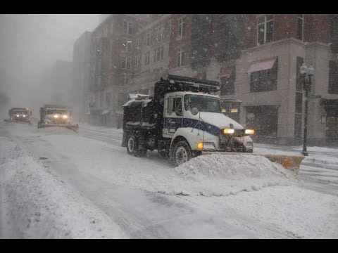
Inwoners van de stad New York krijgen het advies om dinsdag niet de straat op te gaan in verband met een hevige sneeuwstorm. Ook blijven scholen gesloten en ligt het openbaar vervoer grotendeels stil.
"Als je naar buiten moet, doe dat dan zo kort mogelijk. Maar het beste is om binnen te blijven," aldus burgemeester Bill de Blasio maandagavond (lokale tijd).
De oostkust van de Verenigde Staten wordt dinsdag geteisterd door harde wind, hevige sneeuwval en lage temperaturen die enkele graden onder het vriespunt liggen.
Scholen dicht
De bovengrondse metro in New York is dinsdag buiten werking gesteld en de autoriteiten waarschuwen dat mogelijk meer trein- en busdiensten zullen uitvallen. Alle openbare scholen in de stad blijven dicht. "Het wordt een gevaarlijke situatie," zei de gouverneur van New York maandag (lokale tijd) op CBS Radio.
Luchtvaarmaatschappijen American Airlines en Delta Airlines hebben vrijwel alle vluchten op de drie luchthavens van New York en Boston uit voorzorg gecanceld. In totaal gaan aan de oostkust zo'n vierduizend vluchten niet door. Mogelijk wordt het vliegverkeer woensdagochtend hervat.
Verlaten straten in New York door hevige sneeuwstorm Verlaten straten in New York door hevige sneeuwstorm
Noodtoestand
De sneeuwstorm treft vier Amerikaanse staten langs de oostkust. In New York, New Jersey, Pennsylvania en Virginia is de noodtoestand uitgeroepen. In de meeste grote steden zoals Boston en Philadelphia blijven de scholen eveneens dicht en ligt het openbaar vervoer stil.
De sneeuwstorm die dinsdagochtend (lokale tijd) het vaste land zal bereiken, gaat gepaard met hevige sneeuwval. Boston maakt zich op voor 30 centimeter dat in korte tijd zal vallen. Naar verwachting valt in Washington D.C. dinsdag 13 centimeter sneeuw. Daarnaast worden windsnelheden verwacht tot 100 kilometer per uur.
In verband met de storm heeft de Duitse bondskanselier Angela Merkel haar bezoek aan president Donald Trump uitgesteld tot vrijdag. Ook het hoofdkantoor van de Verenigde Naties is dicht. De New Yorkse aandelenbeurs op Wall Street is dinsdag wel geopend.

Volgens mij krijgen ze daar de laatste jaren elk jaar een keer te maken met een ontzagwekkende sneeuwstorm. Zie de jaaroverzichten van 2016 en 2015 waar ook in het noordoosten een enorm pak sneeuw viel
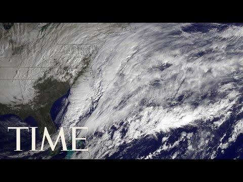
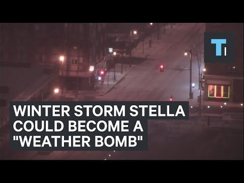
quote:A classic late-season nor’easter has all the ingredients to produce what could be near-record-heavy March snow and dangerously strong winds in coastal cities from Washington, D.C., to Boston. But if the devil were ever in the details, it’s right now. The dividing line between rain and snow in this storm, dubbed Stella by The Weather Channel, will be close enough to the Interstate 95 corridor to keep forecasters sweating. Right now it appears that the meteorological bounty will be mainly in the form of snow for the big East Coast cities. However, just a minor shift in track could bring rain or sleet into the metropolitan areas, at least for a brief period.
There’s no doubt that a big storm is in the cards. Upper-level energy from two sources—a large trough swinging across the Midwest and a upper-level wave at the base of this trough over the Southern Plains—will be joining forces along the East Coast by Tuesday. The interplay between these two factors is just one of the elements of uncertainty on the table.
What’s clear is that a surface low off the central Gulf Coast on Monday morning will begin to strengthen near the Outer Banks Monday night, then rapidly intensify as it moves northeast along and/or just off the East Coast through the day on Tuesday. As shown in Figure 1 below, the 12Z Monday run of the GFS model deepens the low 23 millibars in 24 hours, from 2:00 am EDT Tuesday to 2:00 am Wednesday, as it moves from near Cape Hatteras, NC (1000 mb), to the central coast of Maine (977 mb). This would bring the low very close to the official definition of a meteorological “bomb”—a midlatitude low that deepens at least 24 millibars in 24 hours.

https://www.wunderground.(...)er-looms-for-tuesday


twitter:MJVentrice twitterde op dinsdag 14-03-2017 om 13:10:08#Stella UPDATE: Upstate NY going to be the jackpot zone
snowfall total. This is going to be a historical snow eve… https://t.co/zGoGO9gxCB reageer retweet