WKN Weer, Klimaat en Natuurrampen
Lees alles over het onstuimige weer op onze planeet, volg orkanen en tornado's, zie hoe vulkanen uitbarsten en hoe Moeder Aarde beeft bij een aardbeving. Alles over de verwoestende kracht van onze planeet en tal van andere natuurverschijnselen.


Voorgaande topics
Topicreeks: Aardbevingen
Samenvatting
Een aardbeving is een trilling of schokkende beweging van de aardkorst. Aardbevingen vinden plaats als er in de aardkorst plotseling veel energie vrijkomt. De energie plant zich dan in een golfbeweging vanuit het centrum naar de omgeving voort. Het denkbeeldige punt waar de beving ontstaat, het zwaartepunt van de energiedichtheid, heet het hypocentrum. Het punt aan het aardoppervlak daar loodrecht boven wordt het epicentrum genoemd. Een lijn van gelijke bevingintensiteit rond een epicentrum heet een isoseist. Seismologie is de wetenschap van aardbevingen.
De meeste aardbevingen komen voor in de aardkorst tot op een diepte van ongeveer 30 kilometer. Er komen echter ook bevingen voor op dieptes tot ongeveer 700 kilometer. De meeste aardbevingen komen voor rondom de Grote Oceaan, in het Middellandse Zeegebied, in de Himalaya en Indonesi�. Ook midden in oceanen komen bevingen voor. Aardbevingen die ontstaan onder de zeespiegel worden, minder correct, ook wel zeebevingen genoemd; een vloedgolf of tsunami kan dan het gevolg zijn. Bij aardbevingen is het zo dat 'hoe ondieper een beving des te groter de kans op schade of een tsunami'.
Veel aardbevingen hangen samen met de langzame interne bewegingen van de aardkorst. Op grote schaal kan het de aardschollen betreffen, die langzaam ten opzichte van elkaar bewegen (platentektoniek). Op kleinere schaal vindt er ook binnen de platen deformatie plaats.
Door deze relatieve beweging wordt spanning opgebouwd in de korst. Als de spanning hoog genoeg is kan er een schoksgewijze beweging van het materiaal aan weerszijden van een breuk in de korst optreden: de aardbeving. Hierbij wordt (een deel van) de opgebouwde spanning ontladen. Naschokken zijn kleinere bevingen die binnen enkele uren na de eerste beving voelbaar zijn. Deze zijn vaak het gevolg van spanningsontlading op andere, nabijgelegen delen van dezelfde breuk of op andere nabije breuken. Dit type aardbevingen komt binnen platen voor tot een diepte van enkele tientallen kilometers en aan plaatranden ook tot op grotere diepte.
Aardbevingen op dieptes van enkele honderden kilometers worden vaak toegeschreven aan andere mechanismen. Ten eerste kunnen deze worden veroorzaakt in een subducerende plaat door de overgang van mineralen van een fase naar de andere (zie convectie in de aarde). Wanneer de oude fase metastabiel was, kan de overgang naar de nieuwe fase zeer plotseling zijn. Op een vergelijkbare wijze kan het plotseling loslaten van water uit waterhoudende mineralen in de subducerende plaat een aardbeving veroorzaken.
Kleine aardbevingen zijn het gevolg van vulkanische activiteit (vulkanische aardbevingen) of ontstaan door instorting van holtes in kalksteenformaties of mijnen (instortingsbevingen). Mogelijke andere oorzaken zijn ondergrondse kernproeven en meteorietinslagen.
Menselijk ingrijpen kan bevingen veroorzaken. De bodemdaling door de winning van aardgas brengt aardschokken teweeg. Dit fenomeen doet zich onder meer voor in de provincie Groningen bij het dorp Loppersum.
Hoe ontstaan ze?
Een aardbeving is een trilling of schokkende beweging van de aardkorst. Aardbevingen worden veroorzaakt als er ergens in de aardkorst plotseling veel energie vrijkomt. Dit kan door bijvoorbeeld het langs elkaar heen schuiven van de aardschollen. (Platentektoniek genoemd) Of doordat aardschollen onder/over elkaar schuiven met brute kracht. De wrijving/spanning veroorzaakt dan een breuk/aardbeving.
Breuklijnen, Aardschollen
Op onderstaand plaatje kun je zien waar ter wereld de 'aardschollen' liggen. Op de grens van twee schollen komen dan ook de meeste aardbevingen ter wereld voor.

E�n van de bekendste breuken ter wereld is de San Andreas Faultline (=breuklijn) in Californie. Deze is ontstaan doordat de Pacifische Plaat langzaam langs/onder de Noord Amerikaanse plaat schuift.

Hoe worden ze gemeten?
Aardbevingen komen meestal voor op een diepte tussen de 0 en 30 km. Maar ze kunnen ook op 600 km diepte voorkomen. Het punt aan de aardkorst oppervlakte dat loodrecht boven de plek van de beving staat noemen we het "epicentrum" De bevingen worden in kaart gebracht mbv de "Schaal van Richter (Vernoemd naar de geoloog Francis Richter uit 1935).
De Richter schaal wordt gebruikt om de kracht van een aardbeving aan te geven. Het gaat daarbij om de hoeveelheid energie de vrijkomt tijdens de aardbeving. Op de Richter schaal wordt de kracht aangegeven met een getal. De Schaal van Richter is logaritmisch, dat wil zeggen dat de kracht van de aardbeving 10 keer zo groot is als het Richter getal met 1 toeneemt. Een aardbeving met kracht 6 is dus 10 keer zo zwaar als een aardbeving met kracht 5. Meer info over de richterschaal vind je o.a. in onderstaande links.
De zeventien zwaarste aardbevingen sinds 1900 zijn:

| 1 2 3 4 5 6 7 8 9 10 11 12 13 14 15 16 17 18 | Locatie Datum Kracht 1. Chile 22-mei-1960 9.5 2. Prince William Sound, Alaska 28-mrt-1964 9.2 3. Off W. Coast of N. Sumatra 26-dec-2004 9.1 4. Japan, Honshu 11-mrt-2011 9.0 5. Kamchatka 04-nov-1952 9.0 6. Offshore Maule, Chili 27-feb-2010 8.8 7. Off the Coast of Ecuador 31-jan-1906 8.8 8. Rat Islands, Alaska 04-feb-1965 8.7 9. Northern Sumatra, Indonesia 28-maa-2005 8.6 10. Andreanof Islands, Alaska 09-maa-1957 8.6 11. Assam - Tibet 15-aug-1950 8.6 12. Northern Sumatra, Indonesia 11-apr-2012 8.6 13. Southern Sumatra, Indonesia 12-sep-2007 8.5 14. Kuril Islands 13-okt-1963 8.5 15. Banda Sea, Indonesia 01-feb-1938 8.5 16. Kamchatka 03-feb-1923 8.5 17. Chili-Argentinian border 11-nov-1922 8.5 |
De aardbeving die de meeste slachtoffers kostte was overigens veel lichter. In 1976 deed zich in China een aardbeving voor met een kracht van 8.0. Omdat het een zeer dicht bevolkt gebied was waren er ongeveer 250.000 doden te betreuren. Op 26 december 2004 vond een aardbeving plaats voor de kust van het Indonesische eiland Sumatra. Deze zeebeving had een kracht van 9.0 op de schaal van Richter. Er vielen echter slachtoffers in de hele regio Zuid-Oost Azi� (India, Sri Lanka, Thailand, Indonesi� zelf) als gevolg van de tsunami (vloedgolf) die volgde op de zeebeving. Waarschijnlijk zijn daar ook 200.000 slachtoffers gevallen. Zeer recent, in januari 2010, zorgde een beving van 7.0 voor meer dan 220.000 slachtoffers in Haïti. In mei 2008 vielen er in de Chinese provincie Sichuan ruim 65.000 doden bij een beving van 8.0. In 2003 vielen bij een aardbeving in Iran meer dan 40.000 doden bij een beving in Bam van 6.2, terwijl in 1999 ruim 44.000 mensen de dood vonden bij een beving in Turkije.
Aardbevingen? Ook in Nederland?
Ook in Nederland komen aardbevingen voor. In het zuidoosten worden elk jaar kleine aardbevingen gemeten met een kracht van 2 tot 3 op de schaal van Richter. Soms zijn er sterkere aardbevingen, zoals op 13 april 1992 in de buurt van Roermond met een kracht van 5.8 en in 2002 iets ten oosten van Roermond in Duitsland met een kracht van 4.9.
In Noord-Nederland komen, vooral in Groningen en Drenthe, lichte aardbevingen voor. Die worden naar alle waarschijnlijkheid veroorzaakt door de gaswinning uit de bodem, waardoor de aardbodem zakt. Op 24 oktober 2003 was er in de omgeving van Loppersum een lichte aardbeving met een kracht van 3.0. Het verslag van het KNMI over deze aardbeving vind je hier. In diezelfde omgeving vond ook op 22 september 2003 een (lichtere) aardbeving plaats, kracht 2.3.
Hoeveel aardbevingen vinden er plaats?
Het gemiddeld aantal bevingen per jaar met de bijbehorende magnitude (kracht) zijn:
-3000 met magnitude 5.0-5.9
-100 met magnitude 6.0-6.9
-18 met magnitude 7.0-7.9
-1 met magnitude 8.0 of meer
• Dit plaatje geeft weer waar er aardbevingen zijn geweest tussen 1963 en 1998.
• Dit plaatje geeft weer waar er aardbevingen zijn geweest tussen 1978 en 1987.
Filmpje: Aardbevingskracht in vergelijking tot Aardbevingsintensiviteit
Tsunami's - een gevolg van een zeebeving
Sinds de catastrofale zeebeving op 2e kerstdag 2004 is het woord 'tsunami' niet meer weg te denken uit de woordenboeken. Wat is nou een Tsunami?
Alle gebeurtenissen waarmee een grote hoeveelheid water in korte tijd wordt verplaatst kunnen een tsunami veroorzaken. Vloedgolven kunnen veroorzaakt worden door een zeebeving, een aardbeving waarvan het epicentrum onder de zeespiegel ligt, door een meteoriet, of door een vulkanische uitbarsting onder zee of vlak aan zee, vooral als daarbij door een grote aardverschuiving veel gesteente de zee in schuift. Ook bij plotseling afkalven van een gletsjer of ijsberg kan een vloedgolf ontstaan. Ook kan het zo zijn dat er grote stukken land of gebergte het water invallen. Hierdoor ontstaan vaak kleinere tsunami's omdat er minder water wordt verplaatst.
De meeste tsunami's komen voor rondom de Grote Oceaan, omdat langs de randen daarvan door de platentektoniek de meeste aardbevingen plaatsvinden.

Verloop van de tsunami in 2004
Door de verplaatsing van de zeebodem, vooral als deze kilometers diep plaatsvindt, wordt een enorme kolom water opgetild. Aan het wateroppervlak is daarvan weinig te zien, er ontstaat een golf van misschien een hoogte van enkele decimeters, met een enorme golflengte van 100 tot 400 kilometer. Door deze grote golflengte zijn er op volle zee maar enkele pieken en dalen merkbaar; op een schip zal de tsunami ongemerkt voorbij gaan. Een golf die door de wind wordt veroorzaakt kan weliswaar een veel grotere hoogte bereiken, tot 10 meter, bij een golflengte van 200 meter, maar de energie die in de tsunami is opgeslagen is veel groter. De waterbeweging vindt bij een tsunami plaats tot op de zeebodem, terwijl een golf door de wind slechts aan het oppervlak van de zee te merken is. Een normale golf bereikt een snelheid tot 40 km/uur, maar een tsunami kan zich met een veel hogere snelheid verplaatsen. De periode van de tsunami (het tijdsverloop tussen twee toppen) bedraagt een kwartier tot een uur.
Wat is GEE?
GEE betekent Global Earthquake Explorer. Het is een programma voor je desktop waar je live aardbevingen en data mee ontvangt.
• Developer page
• Download GEE
• Screenshots
Overzichten Real-time aardbevingen
Europa
Rest van de wereld
Naslagwerken / Informatie / Nuttige Links / Sites
Aardbevingen
• Nederlandse Aardbevingsite
• US Geological Survey Website
• WikiPedia Aardbeving
• Natuurrampen pagina
• Europese (realtime) Aardbevingen
• Earthquake - Report
• Aardbevingsdossier Kennislink
• Aardbevingen, overzicht, hoe en waarom
Tsunami's
• WikiPedia Tsunami
• Tsunamidossier Kennislink
Deze OP is te vinden in de FOK!Wiki:
Fok!Wiki OP/Aardbevingen
[ Bericht 1% gewijzigd door Frutsel op 28-10-2016 14:21:12 ]
quote:Op woensdag 2 maart 2016 14:01 schreef Houtenbeen het volgende:
twitter:NewEarthquake twitterde op woensdag 02-03-2016 om 13:54:08 Preliminary: 8.1 earthquake, Southwest of Sumatra, Indonesia. On 2016/03/02 12:49:50 UTC (3m ago, depth 10km). https://t.co/nypWTZYkKz reageer retweettwitter:LastQuake twitterde op woensdag 02-03-2016 om 14:05:36 M7.9 #earthquake strikes 805 km SW of #Padang (#Indonesia) 16 min ago. Effects reported by witnesses: https://t.co/mLsTeQSPhm reageer retweet
 Preliminary: 8.1 earthquake, Southwest of Sumatra, Indonesia. On 2016/03/02 12:49:50 UTC (3m ago, depth 10km).
  M7.9
M7.9 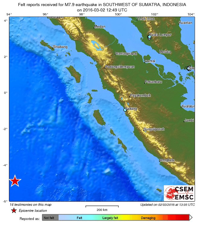

Die gaan daar niks merken, hoogstwaarschijnlijk.quote:
En zeker niks te zeggen over Phuket (Thailand)? Mijn broertje zit daar maar is nu onbereikbaar
Vóór het internet dacht men dat de oorzaak van domheid een gebrek aan toegang tot informatie was. Inmiddels weten we beter.
Rommelt goed daar in de straat van Gibraltar. Wat gebeurd daar dan?quote:2016-03-15 06:30:09.1 35.67 N 3.78 W 2 3.3 STRAIT OF GIBRALTAR
2016-03-15 05:40:37.0 35.63 N 3.76 W 2 3.1 STRAIT OF GIBRALTAR
2016-03-15 05:08:23.2 35.67 N 3.72 W 2 3.3 STRAIT OF GIBRALTAR
2016-03-15 05:02:08.6 35.53 N 3.82 W 10 3.2 STRAIT OF GIBRALTAR
2016-03-15 05:00:08.8 35.79 N 3.70 W 0 3.1 STRAIT OF GIBRALTAR
2016-03-15 04:56:38.5 35.62 N 3.74 W 2 3.2 STRAIT OF GIBRALTAR
2016-03-15 04:46:27.3 35.58 N 3.72 W 10 3.9 STRAIT OF GIBRALTAR
2016-03-15 04:40:39.4 35.72 N 3.69 W 10 5.2 STRAIT OF GIBRALTAR
2016-03-14 09:05:06.3 35.45 N 3.77 W 10 3.0 STRAIT OF GIBRALTAR
2016-03-14 08:47:05.0 35.77 N 8.30 W 15 2.7 WEST OF GIBRALTAR
2016-03-13 21:00:34.2 35.40 N 3.73 W 20 3.2 STRAIT OF GIBRALTAR
2016-03-13 20:54:01.9 35.53 N 3.84 W 10 4.0 STRAIT OF GIBRALTAR
2016-03-13 10:31:24.1 35.74 N 3.66 W 10 3.2 STRAIT OF GIBRALTAR
2016-03-13 00:30:23.2 35.78 N 3.65 W 2 3.0 STRAIT OF GIBRALTAR
2016-03-13 00:26:56.6 35.68 N 3.53 W 10 3.4 STRAIT OF GIBRALTAR
2016-03-12 18:09:19.7 35.67 N 3.63 W 10 3.0 STRAIT OF GIBRALTAR
2016-03-12 15:26:46.4 35.62 N 3.44 W 72 3.3 STRAIT OF GIBRALTAR
2016-03-12 15:22:30.0 35.62 N 3.70 W 10 3.0 STRAIT OF GIBRALTAR
2016-03-12 15:17:12.5 35.72 N 3.68 W 10 4.8 STRAIT OF GIBRALTAR
2016-03-12 15:08:23.7 35.67 N 3.64 W 10 3.0 STRAIT OF GIBRALTAR
Zijn dit allemaal nog naschokken van de 6.1 uit januari? Vrijdag 11 maart was er ook nog een 5.4 in dat gebied.

Vóór het internet dacht men dat de oorzaak van domheid een gebrek aan toegang tot informatie was. Inmiddels weten we beter.
 Op
Op

Bronquote:High risk of a desructive aftershock in Strait of Gibraltar.
A. Please, bear in mind that these are assumptions not yet verified and not a prediction!
B. Todays earthquake with a MT-solution as a thrust-fault, could have been destructive if had happened on shore, since it also had all the others preconditions I assumed: depth at 10 km, magnitude more than 4.9, and eP & ePn seismic waves.
C. Distance to nearest shore is around 40 km. Damage (of VIII EMS-98 scale) epicenters for trust-faults can be as low as 10km away from the seismic one; this may explain why damage was not reported for todays earthquake.
D. MT solutions' mechanisms tend to be the same when shown in aftershocks. Depth varies more often, but usually some aftershocks happen at the same depth. Magnitude can be as high as 5.1 though it is often significantly less than mainshock. Moreover, they sometimes ignite paraller faults and can be equally destructive as mainshocks.
E. Overall, if the sequence moves towards the shores like it happened a couple of months earlier and is of adequate magnitude, there is a chance to be destructive, rather small (10%-15%, arbitrary) but yet existing.
Hier maar even verder om dat andere topic 'on-topic' te latenquote:
[..]
Heb al wel een paar keer een paar kleine gevoeld. Eén keer werd ik er van wakker. Dacht dat er een dieplader voorbij racete. Tot ik me bedacht dat ik in een autoluwe straat woon.
En een keer toen we aan het poolen waren en de ballen ineens begonnen te bewegen
Maar goed, eentje rond de 7 gaat vervelender uitpakken vrees ik
Ik zag ze wel eens in Roemenië maar dacht dat ze mijnbouw-gerelateerd waren ofzo.
Maar er lopen dus echt dikke breuklijnen daar?
edit: ik wist wel van de zware bevingen in Italie in 18e eeuw en begin 1900 maar dit niet
Hoe breuklijnen precies liggen enzo weet ik niet precies. Maar dat je in Italië en op de Balkan redelijk zware aardbevingen kan hebben staat vast.quote:
[..]
Hier maar even verder om dat andere topic 'on-topic' te laten
Ik zag ze wel eens in Roemenië maar dacht dat ze mijnbouw-gerelateerd waren ofzo.
Maar er lopen dus echt dikke breuklijnen daar?
edit: ik wist wel van de zware bevingen in Italie in 18e eeuw en begin 1900 maar dit niet
Begin 20e eeuw waren sowieso roerige tijden op de Balkan.
quote:The region along the line Kochany-Pehchevo-Krupnik-Brezhani in Eastern Macedonia and South-western Bulgaria is one of the most active parts of the high seismic North Aegean area. About 10 strong historic earthquakes (magnitudes higher than 6.0) had occurred in this zone. There are data about very strong earthquakes in this region before the 20th century (still in 52 A.D.). The strongest shallow earthquake in Europe in the last two centuries occurred in the Krupnik-Kresna area on April 4, 1904 , accompanied by long-term seismic activity. Its magnitude is estimated as 7.8. It is well known as Krupnik earthquake. Macroseismic data show that the most significant damages and losses of lives were located in the area Krupnik-Pehchevo-Kochany. This line coincides with WSW-ENE-oriented Krupnik fault. In this paper we present results from joint analysis of geodetic – GPS and precise levelling, geological and seismotectonic data in an attempt to clarify the recent geodynamic settings in region of Krupnik-Kresna. One of the important results in this study is that the geodetic results confirmed the geological hypothesis of the extensional regime of the Krupnik-Kresna region and whole SW Bulgaria . The orientation of the extension is NNW-SSE, perpendicularly to the Krupnik fault.

Gorna Oryahovitsa ligt hier hemelsbreed 5 KM vandaan
"For the man sound of body and serene of mind, there is no such thing as bad weather; Every day has its beauty. And storms which whip the blood, do make it pulse more vigorously."
Mooi dichtbijquote:
[..]
Hoe breuklijnen precies liggen enzo weet ik niet precies. Maar dat je in Italië en op de Balkan redelijk zware aardbevingen kan hebben staat vast.
[ afbeelding ]
Begin 20e eeuw waren sowieso roerige tijden op de Balkan.
[..]
[ afbeelding ]
Gorna Oryahovitsa ligt hier hemelsbreed 5 KM vandaan
6+ had ik wel gedacht. Turkije idem... maar 7+ vond ik uitzonderlijk
het kan schijnbaar welquote:
[..]
Mooi dichtbij
6+ had ik wel gedacht. Turkije idem... maar 7+ vond ik uitzonderlijk
Hier wat afbeeldingen
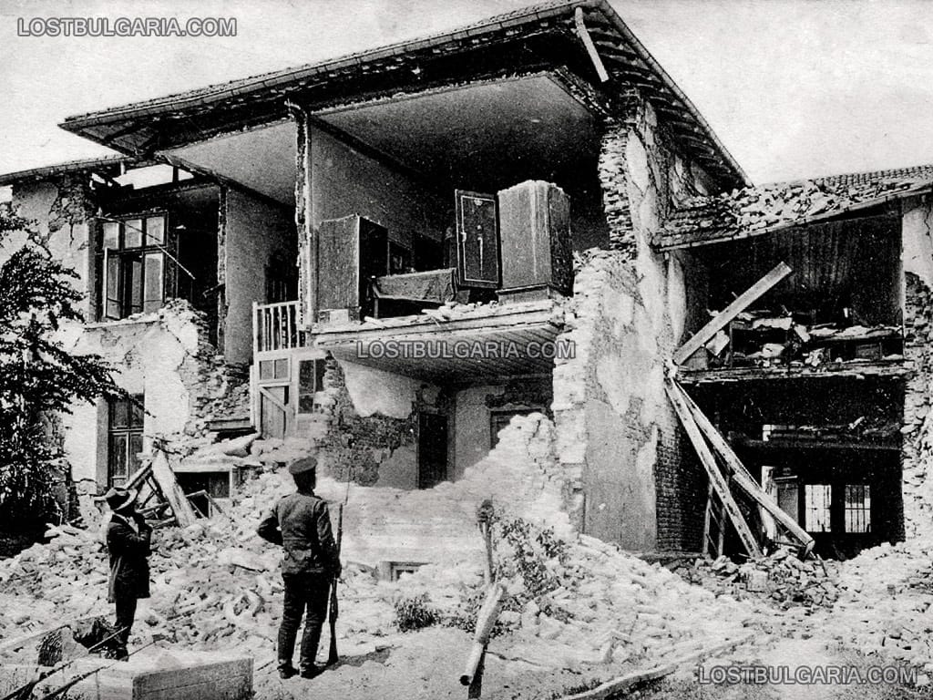
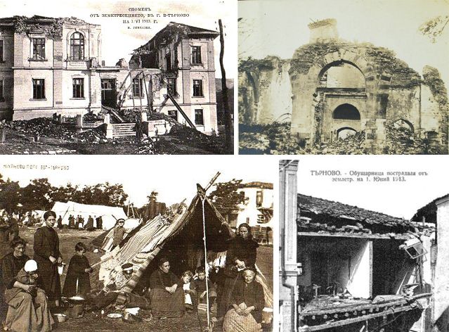
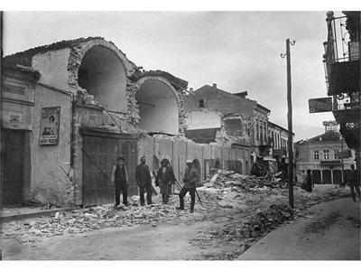
Dit is die ommuurde kerk die je op de foto nadien rechts ziet.


En de laatste foto is wel een bijzondere. De kerktoren die je ziet, staat recht achter mijn huis. Zou goed kunnen dat de foto geschoten is op de plek waar nu mijn woning staat

"For the man sound of body and serene of mind, there is no such thing as bad weather; Every day has its beauty. And storms which whip the blood, do make it pulse more vigorously."
Hier nog de foto van die kerktoren acthter mijn huis vandaag de dag. Omdat de kerk zwaar beschadigd was hebben ze hem helemaal naar beneden gehaald en opnieuw geplaatst. Niet helemaal gelijk maar je ziet de overeenkomst nog wel denk ikquote:

"For the man sound of body and serene of mind, there is no such thing as bad weather; Every day has its beauty. And storms which whip the blood, do make it pulse more vigorously."
Ziet er eigenlijk wel zo uit dat het een nieuwe flinke beving niet zou overlevenquote:
[..]
Hier nog de foto van die kerktoren acthter mijn huis vandaag de dag. Omdat de kerk zwaar beschadigd was hebben ze hem helemaal naar beneden gehaald en opnieuw geplaatst. Niet helemaal gelijk maar je ziet de overeenkomst nog wel denk ik
[ afbeelding ]
Genoeg gaat er een nieuwe beving niet overleven. Denk dat de hele stad weer in puin ligtquote:
[..]
Ziet er eigenlijk wel zo uit dat het een nieuwe flinke beving niet zou overleven
"For the man sound of body and serene of mind, there is no such thing as bad weather; Every day has its beauty. And storms which whip the blood, do make it pulse more vigorously."

Krachtige zeebeving voor kust Russisch schiereiland Kamchatka
Een krachtige zeebeving met de kracht van 6,6 op de Schaal van Richter voor de kust van het Russische schiereiland Kamchatka heeft maandagochtend geen gevaar opgeleverd voor het ontstaan van een tsunami.
Het waarschuwingssysteem van het Pacific Tsunami Warning Center voor landen rond de Stille Oceaan is daarom niet in gang gezet, meldde het centrum. Er zijn geen meldingen van schade op het schiereiland.
De zeebeving deed zich maandagmorgen tegen 07.00 uur (lokale tijd) voor op een diepte van 30 kilometer, op 235 kilometer afstand van de kustplaats Petropavlovsk op Kamchatka.
http://www.nu.nl/buitenla(...)iland-kamchatka.html
6,6 is ook niks.
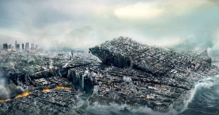
Het is wachten op een 9,9 aardbeving waarbij LA afscheurt van de rest van de USA
Het is wachten op een 9,9 aardbeving waarbij LA afscheurt van de rest van de USA
[b] Op zondag 14 november 2010 18:11 schreef liesje1979 het volgende:[/b]
Zo is daar Godshand, met zijn sarcastische toon,
Die regelmatig een topic voorziet van spot en hoon.
Zo is daar Godshand, met zijn sarcastische toon,
Die regelmatig een topic voorziet van spot en hoon.
WKN / Verwachte 'Big One' in Californië mogelijk nog zwaarder dan gedachtquote:
6,6 is ook niks.
Het is wachten op een 9,9 aardbeving waarbij LA afscheurt van de rest van de USA
Wie weet
quote:Drilling Is Making Oklahoma as Quake Prone as California
Californians have lived with the risk of a damaging earthquake for centuries. Now Oklahomans, and some Kansans, face the same threat, federal seismologists said on Monday.
In an assessment released by the United States Geological Survey, experts said the chance of a destructive temblor in the next year is as great in parts of north-central Oklahoma and southern Kansas — where oil-and-gas operations have set off man-made quakes for about five years — as it is in the shakiest parts of quake-prone California.
The warning came in the agency’s map of earthquake risks, a document that for the first time included the prospects for human-caused quakes.
“By including human-induced events, our assessment of earthquake hazards has significantly increased in parts of the U.S.,” Mark Petersen, the chief of the agency’s Natural Seismic Hazard Mapping Project, said in a news release.

Vóór het internet dacht men dat de oorzaak van domheid een gebrek aan toegang tot informatie was. Inmiddels weten we beter.


zeebeving? altijd link daar...quote:
[b]Op maandag 6 september 2010 00:28 schreef tong80 het volgende:[/b]
GVD Wat moet jij een trotse vader zijn :)
:P
GVD Wat moet jij een trotse vader zijn :)
:P
beving is redelijk diep, 6.2 is dan niet zo zwaar. Mensen vergissen zich nogal een in die logaritmische schaal, 7+ is inderdaad veel zwaarder.quote:
[..]
Jep... maar 6.2 zal niet genoeg zijn voor een tsunami verwacht ik. Heb je echt wel 7+ nodig.
[b]Op maandag 6 september 2010 00:28 schreef tong80 het volgende:[/b]
GVD Wat moet jij een trotse vader zijn :)
:P
GVD Wat moet jij een trotse vader zijn :)
:P
Bij deze niet hoorquote:
[..]
beving is redelijk diep, 6.2 is dan niet zo zwaar. Mensen vergissen zich nogal een in die logaritmische schaal, 7+ is inderdaad veel zwaarder.
10km is heel ondiep qua aardbevingsbegrippen. een 8.0 op 300 km diepte doet vermoedelijk minder schade dan een 6.0 op 10km diepte.
Zij zorgen voor de meeste schade

ik dacht dat 10km vrij diep was, weer wat geleerdquote:
[..]
Bij deze niet hoor
10km is heel ondiep qua aardbevingsbegrippen. een 8.0 op 300 km diepte doet vermoedelijk minder schade dan een 6.0 op 10km diepte.
Zij zorgen voor de meeste schade
[b]Op maandag 6 september 2010 00:28 schreef tong80 het volgende:[/b]
GVD Wat moet jij een trotse vader zijn :)
:P
GVD Wat moet jij een trotse vader zijn :)
:P
Voor onze begrippen wel... maar voor aardbevingen inderdaad niet.quote:
[..]
ik dacht dat 10km vrij diep was, weer wat geleerd
Als ik zelf een 7+ voorbij zie schuiven op de app/twit dan kijk ik meestal eerst naar de diepte. Staat daar 50 km of hoger dan is er vaak niet zoveel aan de hand. (als er een 9+ komt op 50+ dan kan dat natuurlijk wel anders worden)
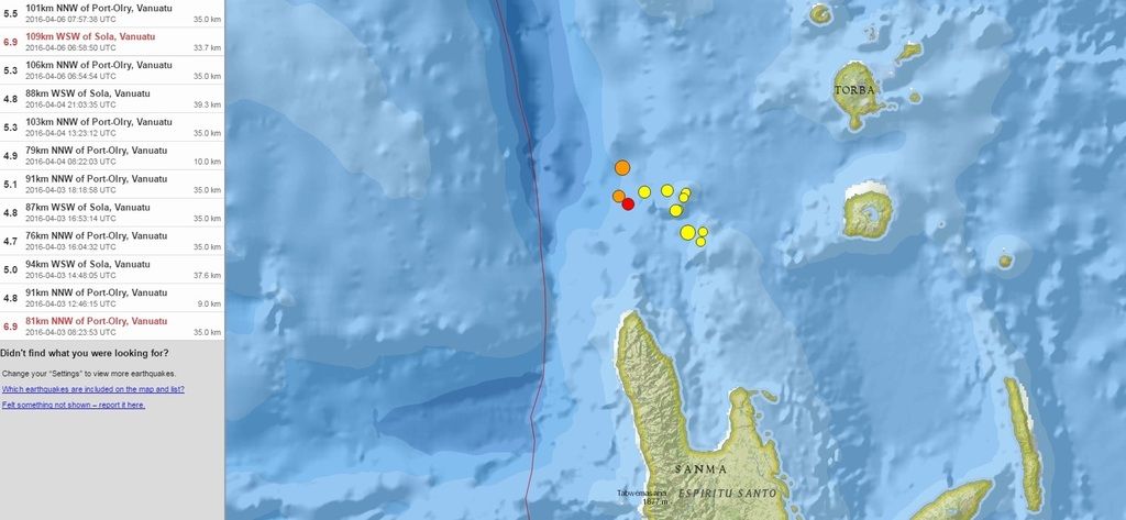
En vandaag de derde... weer een 6.9quote:
Twee 6.9 bevingen bij Vanuatu laatste week... rommelt daar weer goed.
[ afbeelding ]

Gaat dit jaar nog gebeuren...
[b] Op zondag 14 november 2010 18:11 schreef liesje1979 het volgende:[/b]
Zo is daar Godshand, met zijn sarcastische toon,
Die regelmatig een topic voorziet van spot en hoon.
Zo is daar Godshand, met zijn sarcastische toon,
Die regelmatig een topic voorziet van spot en hoon.
twitter:NewEarthquake twitterde op woensdag 13-04-2016 om 16:02:35 Preliminary: 7.1 earthquake, Myanmar. On 2016/04/13 13:55:17 UTC (7m ago, depth 125km). https://t.co/7sgOD5KDn4 reageer retweet
 Preliminary: 7.1 earthquake, Myanmar. On 2016/04/13 13:55:17 UTC (7m ago, depth 125km).


Hmmm....
6.0 tot 6.4 beving... maar op de Shindo scale van Japan gewoon een 7+ (sterkte qua trillingen)
dat is vergelijkbaar met de Kobe aardbeving
Daar kan toch aanzienlijk zware schade zijn. Bevingsdiepte 10 tot 40 km
6.0 tot 6.4 beving... maar op de Shindo scale van Japan gewoon een 7+ (sterkte qua trillingen)
dat is vergelijkbaar met de Kobe aardbeving

Daar kan toch aanzienlijk zware schade zijn. Bevingsdiepte 10 tot 40 km
quote:Earthquake Information (Earthquake Information)
Issued at 21:31 JST 14 Apr 2016
Occurred at (JST) Latitude
(degree) Longitude
(degree) Depth Magnitude Region Name
21:26 JST 14 Apr 2016 32.7N 130.8E 10 km 6.4 Kumamoto-ken Kumamoto-chiho


Shindo meet hoeveel beweging er is aan het aardoppervlak, Richter de energie van de beving.quote:Op donderdag 14 april 2016 19:51 schreef agenda het volgende:
Ziet er niet goed uit.
Wat is het verschil tussen de schaal van richter en de shindo schaal?
Shindo is een betere maat voor de impact voor mensen en gebouwen.
Vóór het internet dacht men dat de oorzaak van domheid een gebrek aan toegang tot informatie was. Inmiddels weten we beter.
Dank je wel voor de uitleg.quote:Op donderdag 14 april 2016 19:54 schreef Perrin het volgende:
[..]
Shindo meet hoeveel beweging er is aan het aardoppervlak, Richter de energie van de beving.
Shindo is een betere maat voor de impact voor mensen en gebouwen.
twitter:USGSBigQuakes twitterde op vrijdag 15-04-2016 om 00:08:30 Prelim M6.5 earthquake Vanuatu Apr-14 21:50 UTC, updates https://t.co/SkrHWzgfuw reageer retweet