WKN Weer, Klimaat en Natuurrampen
Lees alles over het onstuimige weer op onze planeet, volg orkanen en tornado's, zie hoe vulkanen uitbarsten en hoe Moeder Aarde beeft bij een aardbeving. Alles over de verwoestende kracht van onze planeet en tal van andere natuurverschijnselen.


twitter:NWSSPC twitterde op vrijdag 03-04-2015 om 18:58:08 11:58am CDT #SPC_MD 0200 concerning severe potential...tornado watch likely, http://t.co/r7I05HG26h http://t.co/R3W9PSqQpS reageer retweet
 11:58am CDT

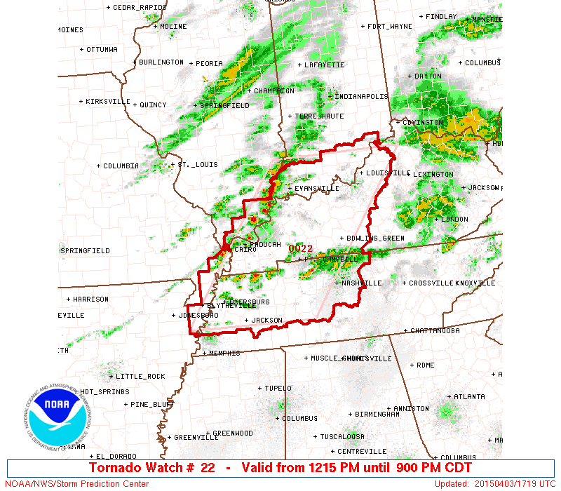
twitter:NWSSPC twitterde op vrijdag 03-04-2015 om 19:20:07 12:20pm CDT #SPC_Watch WW 22 TORNADO AR IL IN KY MO TN 031715Z - 040200Z, http://t.co/7lIyHjDdtj http://t.co/hxPVqw6pKU reageer retweet
[ Bericht 29% gewijzigd door Houtenbeen op 03-04-2015 19:23:47 ]
twitter:weatherchannel twitterde op zaterdag 04-04-2015 om 00:02:52 #Tornado warning until 5:30pm CDT for east side of #Nashville & eastern suburbs. Based on radar. Take cover. http://t.co/PB1HtgSA7Q reageer retweet


twitter:weatherchannel twitterde op zaterdag 04-04-2015 om 02:52:39 7:51pm CT: CONFIRMED #tornado located north of Moores Mill near New Market, #Alabama, moving east at 50 mph. #ALwx http://t.co/Y5aDiPtkpT reageer retweet


Alleen geen chasers daar
Eens zien wat het gaat worden...quote:Op zaterdag 4 april 2015 16:24 schreef Frutsel het volgende:
https://twitter.com/AviWxChasers/status/584357076471713794
outbreak coming up?
quote:
https://twitter.com/AviWxChasers/status/584357076471713794
outbreak coming up?
twitter:breakingweather twitterde op maandag 06-04-2015 om 00:30:38 A dangerous outbreak of severe weather will strike the Central US Wednesday & Thursday. http://t.co/1UcgSWm7cg reageer retweet
 A dangerous outbreak of severe weather will strike the Central US Wednesday & Thursday.
twitter:weatherchannel twitterde op dinsdag 07-04-2015 om 18:55:01 #TorCon of 3 today for central #Missouri; our latest forecast: http://t.co/ZQTeMs94xy #tornado #severe #storms #MOwx http://t.co/UCnOTbNdla reageer retweet

The storms on Wednesday could produce a few tornadoes that are on the ground for a considerable amount of time. Tornadoes of this nature can be especially strong and destructive.
http://www.accuweather.co(...)r-outbrea-1/45123731

http://www.accuweather.co(...)r-outbrea-1/45123731
twitter:TWCBreaking twitterde op dinsdag 07-04-2015 om 21:50:23 Tornado Warning for Spencer and Warrick Counties in IN until 3:15 PM CDT http://t.co/FvDDa6HJz0 reageer retweet
 Tornado Warning for Spencer and Warrick Counties in IN until 3:15 PM CDT
 twitter:weatherchannel twitterde op dinsdag 07-04-2015 om 21:54:37 JUST IN: Santa Claus is under a #tornado warning until 3:15pm CDT. Santa Claus, Indiana, that is. http://t.co/WrznvzclGj reageer retweet

https://tvnweather.com/live
Nu zelfs voor California
[ Bericht 4% gewijzigd door Houtenbeen op 08-04-2015 00:49:57 ]
twitter:weatherchannel twitterde op woensdag 08-04-2015 om 00:25:53 #Tornado Warning in N. CA for central Glenn County until 3:45p PDT. Seek shelter if in path! #CAwx #severe #storm http://t.co/05UAHwYH6Q reageer retweet

[ Bericht 4% gewijzigd door Houtenbeen op 08-04-2015 00:49:57 ]
twitter:weatherchannel twitterde op woensdag 08-04-2015 om 02:15:00 Greater #severe threat Wednesday with #TorCons up to 5 for E. #Kansas & N./central #Oklahoma: http://t.co/w1qUIT7Kw0 http://t.co/6IozLKrV0q reageer retweet


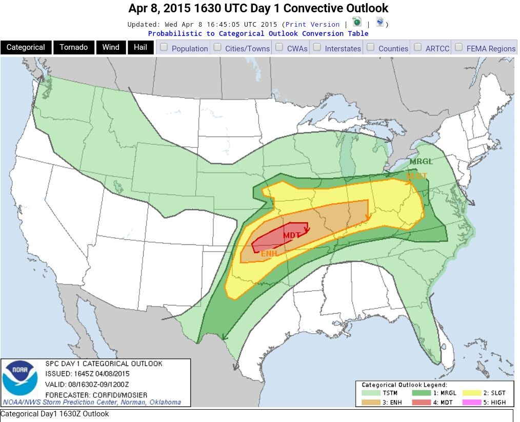
quote:SRN AND CNTRL PLAINS THROUGH THE LOWER MO VALLEY...
PARTIALLY MODIFIED GULF AIR IS IN PLACE OVER THE SRN PLAINS...AND
LOW-LEVEL LOW TO MID 60S F DEWPOINTS SHOULD CHARACTERIZE MUCH OF THE
WARM SECTOR DURING THE AFTERNOON. THE 00Z WED RAOBS INDICATE AN EML
WITH STEEP LAPSE RATES HAS ALREADY ADVECTED ABOVE MUCH OF THIS
REGION...AND DIABATIC WARMING OF THE BOUNDARY LAYER SHOULD BOOST
MLCAPE TO 2500-3500 J/KG WEDNESDAY AFTERNOON. ELEVATED STORMS MAY
DEVELOP EARLY IN THE PERIOD NORTH OF THE STALLED FRONT FROM ERN KS
INTO MO...AND SOME OF THIS ACTIVITY MAY POSE A THREAT FOR LARGE
HAIL. CURRENT INDICATIONS ARE THAT MOST OF THE WARM SECTOR WILL
REMAIN CAPPED MUCH OF THE DAY. SOME MODEL SOLUTIONS INITIATE STORMS
BY EARLY AFTERNOON FROM NRN TX INTO OK...BUT THIS ACTIVITY MIGHT BE
MID-LEVEL CONVECTION ROOTED ABOVE THE CAP AND DEVELOPING IN RESPONSE
TO THE SRN-STREAM JET STREAK.
CURRENT THINKING IS THAT SFC-BASED STORMS WILL INITIATE ALONG THE
DRYLINE-FRONT INTERSECTION OVER NCNTRL OK OR SCNTRL KS BY LATE
AFTERNOON...WHILE OTHER MORE ISOLATED ACTIVITY MAY DEVELOP FARTHER
SW FROM THE ERN TX PANHANDLE INTO WRN TX WITHIN ZONE OF DEEP MIXING
ALONG THE DRYLINE. DEEP-LAYER SHEAR PROFILES WILL STRENGTHEN TO
40-50 KT WITH APPROACH OF THE MID-LEVEL JET STREAK SUPPORTIVE OF
SUPERCELLS CAPABLE OF PRODUCING VERY LARGE HAIL. THREAT FOR
TORNADOES /A COUPLE OF WHICH COULD BE STRONG/ WILL ALSO INCREASE BY
LATE AFTERNOON INTO THE EARLY EVENING AS THE LLJ STRENGTHENS IN
ASSOCIATION WITH DEEPENING LEE LOW. ACTIVITY IS EXPECTED TO DEVELOP
NEWD THROUGH THE MID MS VALLEY AREA DURING THE EVENING WITH A
CONTINUED THREAT FOR LARGE HAIL...DAMAGING WIND AND A FEW TORNADOES.
GIVEN THE POTENTIAL FOR SIGNIFICANT SEVERE...AN UPGRADE TO MODERATE
RISK MIGHT BE NEEDED IN LATER UPDATES ONCE MORE
De torcon voor vandaag is omhoog gegaan naar 6.
twitter:jjabraham twitterde op woensdag 08-04-2015 om 18:05:24 Hey #MidMO: @DrGregForbes just raised the TOR:CON to a 6 in central MO. 60% chance of a tornado within 50 miles. Stay safe today! #CoMO reageer retweet
 Hey
Hey quote:Wednesday, April 8, 2015
Scattered severe thunderstorms in WV, central and south OH, central and south IN, central and south IL, north KY, MO, east and south-central KS, OK, except for panhandle, northwest TX near Childress, Abilene, and Wichita Falls, northwest AR. TOR:CON - 6 central and south MO; 5 southeast KS, north-central OK; 4 southwest OK; 3 rest of area above.
Wednesday Night, April 8, 2015
Severe thunderstorms in central and south IN, central and south IL, west KY, north and west AR, MO, south IA, east and south-central KS, OK except for panhandle, central TX. TOR:CON - 6 central and southwest MO and southeast KS; 5 central and northeast OK; 4 central TX; 3 rest of area.
twitter:TWCBreaking twitterde op woensdag 08-04-2015 om 22:11:09 Tornado Warning for Brown and Monroe Counties in IN until 4:45 PM EDT http://t.co/qufScW2JnY reageer retweet
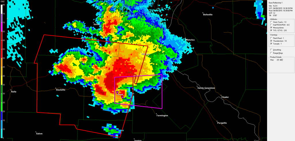
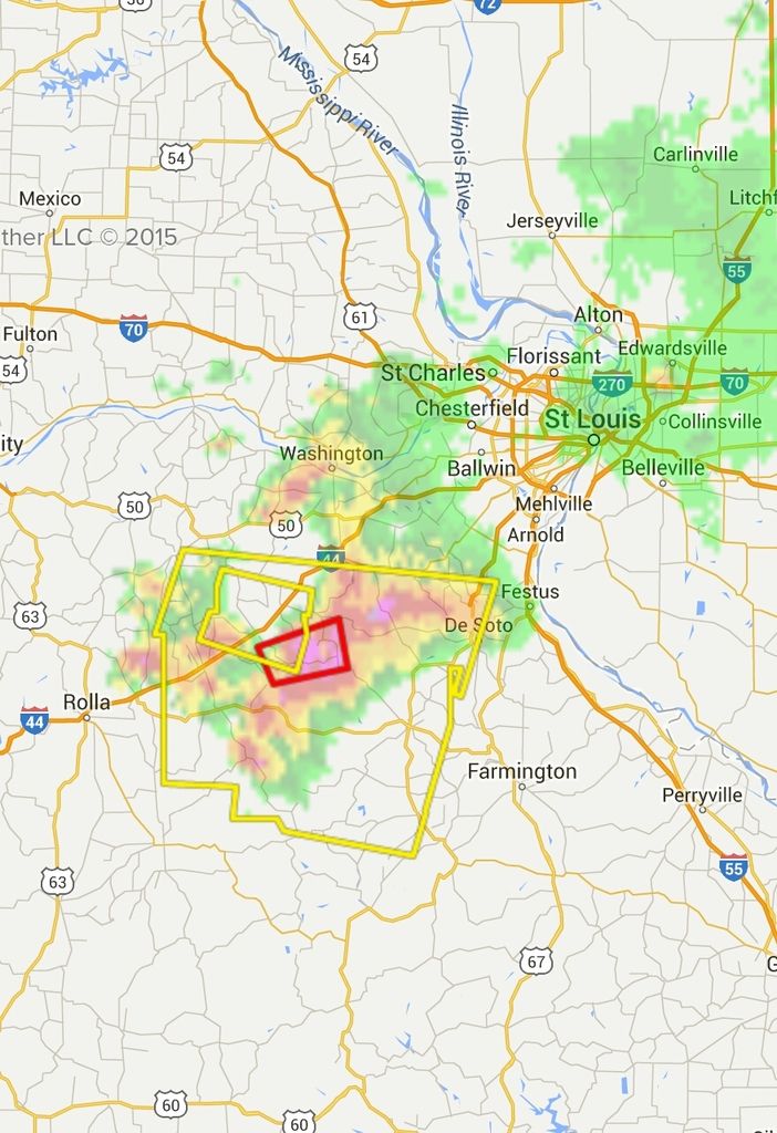
twitter:TWCBreaking twitterde op woensdag 08-04-2015 om 22:20:32 Tornado Warning for Jefferson, St. Francois and Washington Counties in MO until 3:45 PM CDT http://t.co/o2lJwnbObN reageer retweet
[ Bericht 33% gewijzigd door Houtenbeen op 08-04-2015 22:21:15 ]

Never Stop Exploring!
Life begins at the end of your comfort zone!
Follow me on Twitter: https://twitter.com/EdwinKr83 Instagram: https://www.instagram.com/edwinkr83/
Life begins at the end of your comfort zone!
Follow me on Twitter: https://twitter.com/EdwinKr83 Instagram: https://www.instagram.com/edwinkr83/
Die live map met daarop de chasers is niet actief?
*edit: aha https://tvnweather.com/live/
en
http://www.chasertv.com/
*edit: aha https://tvnweather.com/live/
en
http://www.chasertv.com/
Recht zo die gaat, braaf zo die heen.
Via hier, https://www.youtube.com/channel/UCWAN-rRJFLosqgiiIFVpkEQ , is oa Brandon Ivey te volgen. Jammer genoeg problemen met zijn auto. Op de andere stream zijn ze rustig aan het afwachten met een aantal chasers (Tony Laubach, Skip Talbot)
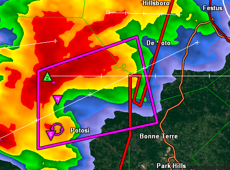
Waarschijnlijk een tornado op de grond? Lijkt wel zo op de radar:
Waarschijnlijk een tornado op de grond? Lijkt wel zo op de radar: