WKN Weer, Klimaat en Natuurrampen
Lees alles over het onstuimige weer op onze planeet, volg orkanen en tornado's, zie hoe vulkanen uitbarsten en hoe Moeder Aarde beeft bij een aardbeving. Alles over de verwoestende kracht van onze planeet en tal van andere natuurverschijnselen.


El Golfo, El Hierro, De plek waar de meeste aardbevingen zijn geregistreerd
[/quote]quote:El Hierro’s Volcanic/Seismic Past
El Hierro is situated in the most southwestern extreme of the Canaries. The island was formed after three successive eruptions, and consequent accumulations, the island emerged from the ocean as an imposing triangular pyramid crowned by a volcano more than 2,000 metres high.
The volcanic activity, principally at the convergence of the three ridges, resulted in the continual expansion of the island. A mere 50,000 years ago, as a result of seismic tremors which produced massive landslides, a giant piece of the island cracked off, crashed down into the ocean and scattered along the seabed. This landslide of more than 300km3 gave rise to the impressive amphitheatre of the El Golfo valley and at the same time caused a tsunami that most likely rose over 100 metres high and probably reached as far as the American coast.
(enkele video's zijn in de OP's van het vorige topics te vinden)
Status Vandaag de dag:
De afgelopen dagen is er wederom (net als de start van het vorige topic) grote activiteit geweest op het eiland. Er zijn weer sterke "vervormingen" zoals het omhoog komen van enkele cm's van een groot deel van het eiland. Daarbij is er ook nog een verplaatsing van een paar cm van noord en zuidkant van het eiland - weg van de plek van de "vervorming".

Zware aardbeving
Als gevolg van de vele activiteit de afgelopen jaren is ten noord-westen van het eiland een zware aardbeving geweest van 5.1
Hoeveel bevingen zijn er geweest sinds de start in 2011?
Zie het bij behorende plaatje:

disclaimer - het plaatje is voor het laatst geactualiseerd in augustus - we leven nu eind december
Links
Live webcams op het eiland El Hierro (niet alles werkt meer)
Zelfde webcams via andere link
Actuele seismische activiteit
AVCan - vulcanologiesch instituut Canarische eilanden
Spaans geografisch instituut
INVOLCAN Facebook pagina
AVCAN facebook pagina
Canariesnews
Tumbit
en op twitter kun je zoeken op #hierro, #elhierro of #viveelhierro
@noticiacanaria Wel veel ander nieuws
@canariesnews
@eruptionsblog
@teideano 1 van de onderzoekers op El Hierro
Gerelateerde topics
WKN / [Vulkanen] The ring of fire #6: Waar diverse vulkanen puffen
WKN / Aardbevingen #16
WKN / Mega tsunami door in zee vallen van eiland La Palma?
eerdere delen
WKN / [breaking] Vulkaanuitbarsting bij Canarische Eilanden
WKN / [breaking] Vulkaanuitbarsting bij Canarische Eilanden #2
WKN / [aktueel] Vulkaanuitbarsting bij Canarische Eilanden #3
WKN / Vulkaanuitbarsting bij Canarische Eilanden #4
WKN / Vulkaanuitbarsting bij Canarische Eilanden #5
[ Bericht 2% gewijzigd door bwt op 28-12-2013 14:24:37 ]
<a href="http://goo.gl/q8fhTe" target="_blank">FAQ?</a>
<a href="http://goo.gl/gYvZFq" target="_blank">Geel is een zonnige en vrolijke kleur, als hij tenminste enigszins warm is gekleurd en wat naar het oranje neigt</a>
<a href="http://goo.gl/gYvZFq" target="_blank">Geel is een zonnige en vrolijke kleur, als hij tenminste enigszins warm is gekleurd en wat naar het oranje neigt</a>
twitter:
 Inflation at El Hierro still up O_O. 6,5cm at some gps stations.
 quote:2013-12-28 13:11 UTC
The first satellite image (Modis Terra satellite) has too much clouds above yesterdays epicenter area to determine color differences in the ocean (the ocean is colored light blue on this location, but these spots are probably clouds). There is another satellite image coming shortly from the Modis Aqua satellite. So hang on to see the latest details.
Click on the link to see it in full size (your computer will need some time to load it!)

<a href="http://goo.gl/q8fhTe" target="_blank">FAQ?</a>
<a href="http://goo.gl/gYvZFq" target="_blank">Geel is een zonnige en vrolijke kleur, als hij tenminste enigszins warm is gekleurd en wat naar het oranje neigt</a>
<a href="http://goo.gl/gYvZFq" target="_blank">Geel is een zonnige en vrolijke kleur, als hij tenminste enigszins warm is gekleurd en wat naar het oranje neigt</a>
Zoals eerder gezegd is dat La Palma idd. Daar heb je de Cumbre Vieja vulkaan die voor het laatst in 1971 was uitgebarsten. In 1949 zorgde dat voor een verzakking van een deel van het eiland, dus het zaakje zou aardig instabiel kunnen zijn.quote:Op zaterdag 28 december 2013 11:37 schreef Scrummie het volgende:
Dit is toch het eiland dat een mega tsunami veroorzaakt als er wat afbreekt ofzo?
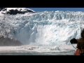
Waar je het mee zou kunnen vergelijken, op een veel kleinere schaal, is een kalvende gletsjer:
(vanaf ongeveer 1:35 begint het spectakel)
twitter:etnaboris twitterde op zaterdag 28-12-2013 om 18:32:04 @CultureVolcan @magmatters Radon is not a gas that comes from the magma, but which comes from the uppermost few meters of the soil (1/2) reageer retweet
 @CultureVolcan @
En waar is dit op gebaseerd?twitter:etnaboris twitterde op zaterdag 28-12-2013 om 18:32:45 @CultureVolcan @magmatters Radon is released when the ground is subjected to fracturing (induced, e.g., by inflation or seismicity) (2/2) reageer retweet
Nou - Hierop:
twitter:teideano twitterde op zaterdag 28-12-2013 om 02:14:39 222Rn measurements at one of our stations in El Hierro.Precursory activity b4 the earthquake? #volcano #science http://t.co/9prar7IssE reageer retweet

<a href="http://goo.gl/q8fhTe" target="_blank">FAQ?</a>
<a href="http://goo.gl/gYvZFq" target="_blank">Geel is een zonnige en vrolijke kleur, als hij tenminste enigszins warm is gekleurd en wat naar het oranje neigt</a>
<a href="http://goo.gl/gYvZFq" target="_blank">Geel is een zonnige en vrolijke kleur, als hij tenminste enigszins warm is gekleurd en wat naar het oranje neigt</a>
Aftermath van de 5.1 / 5.3 beving.
Video en plaatjes.
(gekkepoes had nog een linkje gestuurd.)
Video en plaatjes.
(gekkepoes had nog een linkje gestuurd.)
twitter:teideano twitterde op zondag 29-12-2013 om 03:03:18 http://t.co/gzWAOpC28c Amazing video of El Hierro #quake #volcano #geology #nature #wow reageer retweet

twitter:teideano twitterde op zaterdag 28-12-2013 om 02:55:54 Multiple Rockfalls at El Hierro. #volcano #earthquake #geology via Inma Guedes,http://t.co/007CcpwzCm http://t.co/oCBYhUxN71 reageer retweet

twitter:teideano twitterde op zondag 29-12-2013 om 11:52:09 Aftermath of the 5.3 quake at El Hierro. Pic from Yera Ds. #volcano #geology #nature http://t.co/riu9tyhFvj reageer retweet

twitter:teideano twitterde op zondag 29-12-2013 om 11:53:26 Aftermath of the 5.3 quake at El Hierro. Pic from Yera Ds. #volcano #geology #nature http://t.co/tftuqiR4Yb reageer retweet

<a href="http://goo.gl/q8fhTe" target="_blank">FAQ?</a>
<a href="http://goo.gl/gYvZFq" target="_blank">Geel is een zonnige en vrolijke kleur, als hij tenminste enigszins warm is gekleurd en wat naar het oranje neigt</a>
<a href="http://goo.gl/gYvZFq" target="_blank">Geel is een zonnige en vrolijke kleur, als hij tenminste enigszins warm is gekleurd en wat naar het oranje neigt</a>
Er is een website / blog die een wel erg foute titel heeft:
http://www.wunderground.c(...)no-eruption-20131228
Het gaat hier niet om el-hierro maar om de vulkaan uitbarsting van el salvador Chaparrastique vulkaan.
Van de afgelopen 15 dagen
En van de afgelopen 36 uur
[ Bericht 18% gewijzigd door bwt op 30-12-2013 14:30:23 ]
http://www.wunderground.c(...)no-eruption-20131228
Het gaat hier niet om el-hierro maar om de vulkaan uitbarsting van el salvador Chaparrastique vulkaan.
twitter:VolcanoReport twitterde op maandag 30-12-2013 om 09:51:31 El #Hierro #Volcano Crisis: New data showing changing (but still present) deformations - http://t.co/8YJ4WxbHdK http://t.co/bfjOAPmCNM reageer retweet

twitter:teideano twitterde op maandag 30-12-2013 om 11:00:14 El Hierro still inflating, no seismicity detected. Up to 8.3 cm at some sites, strange behaviour. #volcano #geology http://t.co/eQU9rI7tEx reageer retweet

Plaatje van alle bevingen tot nu toe uit de OP bijgewerkt. Laat nu ook van augustus tot nu toe zien.quote:2013-12-30 08:03 UTC
NO more earthquakes, very calm graphs but again spectacular deformation charts.
Deformations are giving a totally changed pattern this morning. The Southern areas are subsiding. The eastern central area is stabilizing BUT the western central and northern areas are inflating (western area very strong). HI10 (El Julan) has no data for the second day in a row. The changing deformation pattern shows the biggest magma movement below the island concentrating in the El Golfo area (Sabinosa to Frontera) and is an additional sign that the crisis isnt over yet.
The strongest deformation today is noted in Sabinosa (GPS station HI03) where the ground was lifted 3 cm in less than 24 hours. The station HI04 (slightly west of HI03 (see map) has however stabilized data.
This crisis will only end when the deformations are stabilizing everywhere.
Van de afgelopen 15 dagen

En van de afgelopen 36 uur

[ Bericht 18% gewijzigd door bwt op 30-12-2013 14:30:23 ]
<a href="http://goo.gl/q8fhTe" target="_blank">FAQ?</a>
<a href="http://goo.gl/gYvZFq" target="_blank">Geel is een zonnige en vrolijke kleur, als hij tenminste enigszins warm is gekleurd en wat naar het oranje neigt</a>
<a href="http://goo.gl/gYvZFq" target="_blank">Geel is een zonnige en vrolijke kleur, als hij tenminste enigszins warm is gekleurd en wat naar het oranje neigt</a>
Ben benieuwd wat de berichtgeving van vandaag zal geven.
Het lijkt er namelijk wel heel erg sterk op dat alle registratie stations weer aan het zakken zijn.
BEHALVE HI10.
Het lijkt er namelijk wel heel erg sterk op dat alle registratie stations weer aan het zakken zijn.
BEHALVE HI10.
<a href="http://goo.gl/q8fhTe" target="_blank">FAQ?</a>
<a href="http://goo.gl/gYvZFq" target="_blank">Geel is een zonnige en vrolijke kleur, als hij tenminste enigszins warm is gekleurd en wat naar het oranje neigt</a>
<a href="http://goo.gl/gYvZFq" target="_blank">Geel is een zonnige en vrolijke kleur, als hij tenminste enigszins warm is gekleurd en wat naar het oranje neigt</a>
Inderdaad:
De tremor en bevingen zijn nog niet helemaal weg hoor:
Overzicht van wat waar beeft
Afgelopen 36 uur:
Afgelopen 15 dagen
quote:2013-12-31 08:52 UTC
What we had expected last night was confirmed this morning by the new deformation data : a general subsidence (deflation) of the island (remark : a couple of signals – HI01 and HI10 – were not updated).
Frontera had a 1 day deflation of 4 cm!.
Yesterday we saw the last tremor disappear from various seismographs. Tremor is the indication that magma is moving somewhere below the island.
The 2 new earthquakes have no special meaning as they will be probably generated by deformation stress and not by magma stress or movement. This will certainly happen more the next few days.
How long will it take to the next crisis ? Nobody knows as it can happen tomorrow or next year, but scientists are convinced that more activity periods will follow.
We were once again happily surprised by the many people following this crisis via earthquake-report.com. We will continue this report also in the future. Please continue to send a comment when you see something irregular on one of the seismographs.


De tremor en bevingen zijn nog niet helemaal weg hoor:

Overzicht van wat waar beeft
Afgelopen 36 uur:

Afgelopen 15 dagen

<a href="http://goo.gl/q8fhTe" target="_blank">FAQ?</a>
<a href="http://goo.gl/gYvZFq" target="_blank">Geel is een zonnige en vrolijke kleur, als hij tenminste enigszins warm is gekleurd en wat naar het oranje neigt</a>
<a href="http://goo.gl/gYvZFq" target="_blank">Geel is een zonnige en vrolijke kleur, als hij tenminste enigszins warm is gekleurd en wat naar het oranje neigt</a>
En ja hoor, we gaan nog lekker actief het nieuwe jaar in.
quote:2014-01-01 13:23 UTC
Renewed increasing tremor is visible in the El Golfo area (TAB en TAN seismographs). Remember that we mentioned this morning that HI04 Sabinosa area GPS station had an increase of at least 2 cm during the last 24 hours.
2014-01-01 10:44 UTC
4 earthquakes since our latest update. The M2.1 at 3 km depth earthquake was located to the south of La Restinga in the Las Calmas sea
Ecxept for the HI04 GPS (Sabinosa) who shows a lifting of 2 cm, almost all the other stations stabilizes based on the new IGN deformation data.
Link to graph of HI00; HI08, HI09 and HI10
Link to graph of HI01, FRON, HI02, HI03 and HI04

<a href="http://goo.gl/q8fhTe" target="_blank">FAQ?</a>
<a href="http://goo.gl/gYvZFq" target="_blank">Geel is een zonnige en vrolijke kleur, als hij tenminste enigszins warm is gekleurd en wat naar het oranje neigt</a>
<a href="http://goo.gl/gYvZFq" target="_blank">Geel is een zonnige en vrolijke kleur, als hij tenminste enigszins warm is gekleurd en wat naar het oranje neigt</a>
1252804 01/01/2014 23:12:31 27.6679 -18.2876 17 1.9 4 SW FRONTERA.IHIquote:2014-01-02 09:00 UTC
NO new deformation data yet.
1 earthquake listed by IGN
Some tremor, who started yesterday, is still present at the Western El Golfo stations.

De beving van 6:56 lijkt een tremor en beving door elkaar - tegen de 2.0 aan. Hopelijk komt deze straks ook op de lijst te staan.

[ Bericht 5% gewijzigd door bwt op 02-01-2014 11:15:52 ]
<a href="http://goo.gl/q8fhTe" target="_blank">FAQ?</a>
<a href="http://goo.gl/gYvZFq" target="_blank">Geel is een zonnige en vrolijke kleur, als hij tenminste enigszins warm is gekleurd en wat naar het oranje neigt</a>
<a href="http://goo.gl/gYvZFq" target="_blank">Geel is een zonnige en vrolijke kleur, als hij tenminste enigszins warm is gekleurd en wat naar het oranje neigt</a>
En de rust keert weer terug.
Slechts 2 bevingen in de laatste 36 uur.
Voor de laatste 15 dagen is het nog wel iets drukker
[edit1]
De grafieken van deformatie zijn ook weer bijgewerkt.
Station HI10 die enige dagen niet werdt bijgewerkt is weer online
Overall is ere inderdaad een stabilisatie geweest - vrijwel alle stations zakten in - naar er zijn een aantal stations die nu weer een paar dagen een uplift hebben.
Klik op de plaatjes voor de grotere versie.
(voor als je wilt weten waar deze staions staan: hier dus)
[edit2]
En mijn vermoeden bevestigd
[ Bericht 32% gewijzigd door bwt op 03-01-2014 11:08:27 ]
Slechts 2 bevingen in de laatste 36 uur.

Voor de laatste 15 dagen is het nog wel iets drukker

[edit1]
De grafieken van deformatie zijn ook weer bijgewerkt.
Station HI10 die enige dagen niet werdt bijgewerkt is weer online
Overall is ere inderdaad een stabilisatie geweest - vrijwel alle stations zakten in - naar er zijn een aantal stations die nu weer een paar dagen een uplift hebben.
Klik op de plaatjes voor de grotere versie.


(voor als je wilt weten waar deze staions staan: hier dus)
[edit2]
En mijn vermoeden bevestigd
twitter:
[ Bericht 32% gewijzigd door bwt op 03-01-2014 11:08:27 ]
<a href="http://goo.gl/q8fhTe" target="_blank">FAQ?</a>
<a href="http://goo.gl/gYvZFq" target="_blank">Geel is een zonnige en vrolijke kleur, als hij tenminste enigszins warm is gekleurd en wat naar het oranje neigt</a>
<a href="http://goo.gl/gYvZFq" target="_blank">Geel is een zonnige en vrolijke kleur, als hij tenminste enigszins warm is gekleurd en wat naar het oranje neigt</a>
De stijgingen lijken weer allemaal af te zakken.
Situatie lijkt zich dus echt te stabiliseren.
[edit]
Zo is het ook duidelijk met de bevingen. Een heeeel stuk rustiger
1252988 04/01/2014 08:56:02 27.7452 -18.3208 12 2.2 mbLg W FRONTERA.IHI [+]
1252974 03/01/2014 21:31:07 27.7283 -18.2901 16 2.0 mbLg W FRONTERA.IHI [+]
1252804 01/01/2014 23:12:31 27.6679 -18.2876 17 1.9 mbLg SW FRONTERA.IHI [+]
[ Bericht 45% gewijzigd door bwt op 04-01-2014 12:37:35 ]
<a href="http://goo.gl/q8fhTe" target="_blank">FAQ?</a>
<a href="http://goo.gl/gYvZFq" target="_blank">Geel is een zonnige en vrolijke kleur, als hij tenminste enigszins warm is gekleurd en wat naar het oranje neigt</a>
<a href="http://goo.gl/gYvZFq" target="_blank">Geel is een zonnige en vrolijke kleur, als hij tenminste enigszins warm is gekleurd en wat naar het oranje neigt</a>
Gister een stevige beving met nog geen 2 minuten later een kleinere:
1252989 04/01/2014 11:38:02 27.6323 -17.9252 9 Sentido 2.8 4 SE EL PINAR.IHI
1252991 04/01/2014 11:39:46 27.6384 -17.9434 10 1.8 4 SE EL PINAR.IHI
1253005 05/01/2014 00:53:54 27.7957 -18.3175 11 2.3 4 W FRONTERA.IHI
Deze zit in het westelijke gebied van de 5.1/5.3 beving
[edit]
Ook La Restinga geeft een daling aan (check de vorige link)
[ Bericht 3% gewijzigd door bwt op 05-01-2014 16:24:19 ]


1252989 04/01/2014 11:38:02 27.6323 -17.9252 9 Sentido 2.8 4 SE EL PINAR.IHI

1252991 04/01/2014 11:39:46 27.6384 -17.9434 10 1.8 4 SE EL PINAR.IHI

1253005 05/01/2014 00:53:54 27.7957 -18.3175 11 2.3 4 W FRONTERA.IHI
Deze zit in het westelijke gebied van de 5.1/5.3 beving
Alleen meetstation HI09 (La Restinga) lijkt nog iets of wat om hoog te gaan. Alle andere lijken te dalen.quote:2014-01-03 13:25 UTC
Another special event took place very recently, 2 relatively shallow earthquakes (9 and 10 km deep) in a new area to the east of La Restinga. The first one being a strong M2.8 earthquake, the second (aftershock?) a M1.8 earthquake 1 minute and 44 seconds later. Especially the location is intriguing us.
[edit]
Ook La Restinga geeft een daling aan (check de vorige link)

[ Bericht 3% gewijzigd door bwt op 05-01-2014 16:24:19 ]
<a href="http://goo.gl/q8fhTe" target="_blank">FAQ?</a>
<a href="http://goo.gl/gYvZFq" target="_blank">Geel is een zonnige en vrolijke kleur, als hij tenminste enigszins warm is gekleurd en wat naar het oranje neigt</a>
<a href="http://goo.gl/gYvZFq" target="_blank">Geel is een zonnige en vrolijke kleur, als hij tenminste enigszins warm is gekleurd en wat naar het oranje neigt</a>
En dan de melding van vandaag...........quote:2014-01-05 20:19 UTC
Our yesterday’s update was unfortunately not published.
Todays picture is somewhat like the preceding days. Almost no earthquakes, subsidence (even strong) in some parts again (weak) lifting in other parts.
Some tremor is still present in some parts of the island (probably due to a very sensitive scale). When we see this kind of tremor, and if the weather is not the source, this is mostly followed by a weak or even stronger lifting. We are curious what the current situation will generate on tomorrow’s deformation.
The picture below is from the lighthouse seismograph. As the amplitude on every seismograph is different it is hard to say what exactly happens.
As long as the deformations (see links below) are not stabilized, we will continue to follow up the situation on a daily basis (in fact many times per day)
quote:2014-01-06 10:15 UTC
NO earthquakes, but almost all the GPS deformation data slightly up. Tremor continues to show at the same stations than yesterday but is decreasing strongly the last couple of hours.
<a href="http://goo.gl/q8fhTe" target="_blank">FAQ?</a>
<a href="http://goo.gl/gYvZFq" target="_blank">Geel is een zonnige en vrolijke kleur, als hij tenminste enigszins warm is gekleurd en wat naar het oranje neigt</a>
<a href="http://goo.gl/gYvZFq" target="_blank">Geel is een zonnige en vrolijke kleur, als hij tenminste enigszins warm is gekleurd en wat naar het oranje neigt</a>
En het jaaroverzicht komt bij iedereen in beeld - zoook bij de de onderzoekers
twitter:teideano twitterde op maandag 06-01-2014 om 16:20:37 El Hierro 2013 seismic activity. 4120 earthquakes located. #geology #science #nature Source: http://t.co/JDFqxgRY5n http://t.co/uqYeVtsBFy reageer retweet

twitter:teideano twitterde op maandag 06-01-2014 om 16:28:45 339 were at least >M3, 31 >M4, 7 >M4,5 and 1 M>5. We can say it was an interesting year. #geology #volcano #nature http://t.co/EKmzyDMZXz reageer retweet

<a href="http://goo.gl/q8fhTe" target="_blank">FAQ?</a>
<a href="http://goo.gl/gYvZFq" target="_blank">Geel is een zonnige en vrolijke kleur, als hij tenminste enigszins warm is gekleurd en wat naar het oranje neigt</a>
<a href="http://goo.gl/gYvZFq" target="_blank">Geel is een zonnige en vrolijke kleur, als hij tenminste enigszins warm is gekleurd en wat naar het oranje neigt</a>
het zwakt dus echt af.quote:2014-01-07 08:30 UTC
Vertical deformations are down all over the island again.
Seismographs are showing the same amplitude than yesterday evening although the waves have decreased already somewhat (6 to 4 meter average)
No new earthquakes.
<a href="http://goo.gl/q8fhTe" target="_blank">FAQ?</a>
<a href="http://goo.gl/gYvZFq" target="_blank">Geel is een zonnige en vrolijke kleur, als hij tenminste enigszins warm is gekleurd en wat naar het oranje neigt</a>
<a href="http://goo.gl/gYvZFq" target="_blank">Geel is een zonnige en vrolijke kleur, als hij tenminste enigszins warm is gekleurd en wat naar het oranje neigt</a>
Vulkanisch is het erg rustig.
Het weer op de canariesche eilanden gaat weer lekker....
En er komt nog meer slecht weer aan:
[ Bericht 33% gewijzigd door bwt op 09-01-2014 14:28:02 ]
Het weer op de canariesche eilanden gaat weer lekker....
twitter:teideano twitterde op donderdag 09-01-2014 om 10:19:10 #weather #nature Amazing Hailstorm at Fasnia, Tenerife, 500m a.s.l. Canary Islands http://t.co/5EydXYtNez reageer retweet

En er komt nog meer slecht weer aan:
twitter:teideano twitterde op donderdag 09-01-2014 om 14:23:07 #alertacanarias #FMACanarias #meteo La borrasca, sobre Canarias ahora mismo, preciosa situación http://t.co/dI6xmZX1kD reageer retweet

[ Bericht 33% gewijzigd door bwt op 09-01-2014 14:28:02 ]
<a href="http://goo.gl/q8fhTe" target="_blank">FAQ?</a>
<a href="http://goo.gl/gYvZFq" target="_blank">Geel is een zonnige en vrolijke kleur, als hij tenminste enigszins warm is gekleurd en wat naar het oranje neigt</a>
<a href="http://goo.gl/gYvZFq" target="_blank">Geel is een zonnige en vrolijke kleur, als hij tenminste enigszins warm is gekleurd en wat naar het oranje neigt</a>
En dan zie je dit in de grafieken:
En een paar uur later deze:
Of het nu de storm is of iets anders???
Op de andere grafieken is niets terug te vinden
[ Bericht 3% gewijzigd door bwt op 10-01-2014 10:45:57 ]

En een paar uur later deze:

Of het nu de storm is of iets anders???
Op de andere grafieken is niets terug te vinden
[ Bericht 3% gewijzigd door bwt op 10-01-2014 10:45:57 ]
<a href="http://goo.gl/q8fhTe" target="_blank">FAQ?</a>
<a href="http://goo.gl/gYvZFq" target="_blank">Geel is een zonnige en vrolijke kleur, als hij tenminste enigszins warm is gekleurd en wat naar het oranje neigt</a>
<a href="http://goo.gl/gYvZFq" target="_blank">Geel is een zonnige en vrolijke kleur, als hij tenminste enigszins warm is gekleurd en wat naar het oranje neigt</a>
quote:2014-01-12 09:38 UTC
Time to make a new update, just to say that the activity below the island has come to a standstill. Only 2 earthquakes since our latest report of earthquakes (1 of these 2 in the region of the M5.1 earthquake relatively far out in the Ocean).
The amplitude of the seismograms is back to very low levels. The increased amplitude the last couple of days was generated by a stormy sea. On some seismographs one could see clearly the tides !
Deformations show small ups and downs but are in average constant.
quote:2014-01-13 06:09 UTC
The activity on all the Canary Islands seismographs are due to the very strong earthquake out of the coast of Puerto Rico earlier today. It has NO link at all with the El Hierro activity. Thanks for reporting in the comments though.

<a href="http://goo.gl/q8fhTe" target="_blank">FAQ?</a>
<a href="http://goo.gl/gYvZFq" target="_blank">Geel is een zonnige en vrolijke kleur, als hij tenminste enigszins warm is gekleurd en wat naar het oranje neigt</a>
<a href="http://goo.gl/gYvZFq" target="_blank">Geel is een zonnige en vrolijke kleur, als hij tenminste enigszins warm is gekleurd en wat naar het oranje neigt</a>
quote:2014-01-18 20:02 UTC
We are noticing increasing tremor in the ctan and cjul seismographs this morning (Ctan and Ctab have both been stopped or hided from public viewing by IGN). We do not think that the current increase is due to bad weather or increasing waves although a slight increase in waves occurred earlier. NO additional earthquakes. We will keep an eye the following hours and days to find out eventual changes.
2014-01-18 08:55 UTC
THE news the last couple of hours at El Hierro was the report of AVCAN that a lot of pumice was collected the last 24 hours in the waters and at the beach of Arenas Blancas at the West Coast of the Island. The pumice will have to be analyzed by specialized laboratories to find a clue where it comes from. This will not be easy at all as the instruments are not showing any traces of eruptive activity at this moment besides a weak increase in tremor on a couple of seismographs (which can also have been caused by the waves).
We do not know whether the strong subsidence of some GPS stations are related to the newly found pumice.

In het avcan verhaal staan meer foto's

<a href="http://goo.gl/q8fhTe" target="_blank">FAQ?</a>
<a href="http://goo.gl/gYvZFq" target="_blank">Geel is een zonnige en vrolijke kleur, als hij tenminste enigszins warm is gekleurd en wat naar het oranje neigt</a>
<a href="http://goo.gl/gYvZFq" target="_blank">Geel is een zonnige en vrolijke kleur, als hij tenminste enigszins warm is gekleurd en wat naar het oranje neigt</a>
Nou, na druk verbouwen en verhuizen even alles na gekeken.
Het is weer/nog steeds rustig op el Hierro.
Het is weer/nog steeds rustig op el Hierro.
<a href="http://goo.gl/q8fhTe" target="_blank">FAQ?</a>
<a href="http://goo.gl/gYvZFq" target="_blank">Geel is een zonnige en vrolijke kleur, als hij tenminste enigszins warm is gekleurd en wat naar het oranje neigt</a>
<a href="http://goo.gl/gYvZFq" target="_blank">Geel is een zonnige en vrolijke kleur, als hij tenminste enigszins warm is gekleurd en wat naar het oranje neigt</a>
Ennnog meer info. Hoewel de grafieken van IGN al weer ff stil staan (sinds 21 januari) is er schijnbaar toch nog iets gaande.
De mij bekende grafieken laten het laatste stukje van die pluim niet meer zien.
(grafieken die ik bedoel: 1e en 2e)
[ Bericht 2% gewijzigd door bwt op 28-01-2014 10:48:45 ]
twitter:teideano twitterde op zaterdag 18-01-2014 om 11:26:43 Deformation at El Hierro again on the rise. The game is not over yet. #volcano #science #geology #nature http://t.co/VWJpEIuryV reageer retweet

De mij bekende grafieken laten het laatste stukje van die pluim niet meer zien.
(grafieken die ik bedoel: 1e en 2e)
[ Bericht 2% gewijzigd door bwt op 28-01-2014 10:48:45 ]
<a href="http://goo.gl/q8fhTe" target="_blank">FAQ?</a>
<a href="http://goo.gl/gYvZFq" target="_blank">Geel is een zonnige en vrolijke kleur, als hij tenminste enigszins warm is gekleurd en wat naar het oranje neigt</a>
<a href="http://goo.gl/gYvZFq" target="_blank">Geel is een zonnige en vrolijke kleur, als hij tenminste enigszins warm is gekleurd en wat naar het oranje neigt</a>
Alles is weer rustig
Grafieken (zie vorige post) werken weer en laten enige fluctuatie zien. maar niet noemenswaardg of zo
Grafieken (zie vorige post) werken weer en laten enige fluctuatie zien. maar niet noemenswaardg of zo
<a href="http://goo.gl/q8fhTe" target="_blank">FAQ?</a>
<a href="http://goo.gl/gYvZFq" target="_blank">Geel is een zonnige en vrolijke kleur, als hij tenminste enigszins warm is gekleurd en wat naar het oranje neigt</a>
<a href="http://goo.gl/gYvZFq" target="_blank">Geel is een zonnige en vrolijke kleur, als hij tenminste enigszins warm is gekleurd en wat naar het oranje neigt</a>
quote:2014-02-05 10:47 UTC
This is the seismicity below the island since our last update. A limited number of daily earthquakes after all.

Na een paar heel erg rustige dagen lijkt alles weer een beetje op te starten
<a href="http://goo.gl/q8fhTe" target="_blank">FAQ?</a>
<a href="http://goo.gl/gYvZFq" target="_blank">Geel is een zonnige en vrolijke kleur, als hij tenminste enigszins warm is gekleurd en wat naar het oranje neigt</a>
<a href="http://goo.gl/gYvZFq" target="_blank">Geel is een zonnige en vrolijke kleur, als hij tenminste enigszins warm is gekleurd en wat naar het oranje neigt</a>
En deze is 40 KM diep bij LaPalma
1257345 10/02/2014 05:56:49 28.8254 -17.7414 40 I-II 3.5 4 NE LOS SAUCES.ILP
En nee, dit is echt niet gevaarlijk. Maar wel noemens waardig.
1257345 10/02/2014 05:56:49 28.8254 -17.7414 40 I-II 3.5 4 NE LOS SAUCES.ILP

En nee, dit is echt niet gevaarlijk. Maar wel noemens waardig.
twitter:teideano twitterde op maandag 10-02-2014 om 12:09:41 Terremoto de 3,5 grados en la isla de La Palma, Canarias, sentido por parte de la población. #ciencia #naturaleza http://t.co/PSEIjjxcbQ reageer retweet
 Terremoto de 3,5 grados en la isla de La Palma, Canarias, sentido por parte de la población.
 quote:Translation: Earthquake of 3.5 degrees on the island of La Palma, Canary Islands, felt by the population
<a href="http://goo.gl/q8fhTe" target="_blank">FAQ?</a>
<a href="http://goo.gl/gYvZFq" target="_blank">Geel is een zonnige en vrolijke kleur, als hij tenminste enigszins warm is gekleurd en wat naar het oranje neigt</a>
<a href="http://goo.gl/gYvZFq" target="_blank">Geel is een zonnige en vrolijke kleur, als hij tenminste enigszins warm is gekleurd en wat naar het oranje neigt</a>
1258429 17/02/2014 06:12:32 27.8790 -18.3316 10 2.9 4 NW FRONTERA.IHI
van het 36 uur overzicht
En dan de anderen ook maar gelijk
15 daags overzicht
en 90 daags overzicht

van het 36 uur overzicht

En dan de anderen ook maar gelijk
15 daags overzicht

en 90 daags overzicht

<a href="http://goo.gl/q8fhTe" target="_blank">FAQ?</a>
<a href="http://goo.gl/gYvZFq" target="_blank">Geel is een zonnige en vrolijke kleur, als hij tenminste enigszins warm is gekleurd en wat naar het oranje neigt</a>
<a href="http://goo.gl/gYvZFq" target="_blank">Geel is een zonnige en vrolijke kleur, als hij tenminste enigszins warm is gekleurd en wat naar het oranje neigt</a>
Volgens mij beeft het el hierzo in Groningen meer dan el daarzo op El Hierro 
(maar toch wel even wat waardering voor je werk wat je in dit topic steekt)
(maar toch wel even wat waardering voor je werk wat je in dit topic steekt)
Als het niet met een hamer te repareren is, is het een elektrisch probleem.
Inderdaad, In groningen gebeurd er meer.
Maar het kan zo maar omdraaien. Heeft het eiland al vaker laten zien.
En weer een "soort van" update - van Tenerife
[ Bericht 0% gewijzigd door bwt op 18-02-2014 12:55:58 ]
Maar het kan zo maar omdraaien. Heeft het eiland al vaker laten zien.
En weer een "soort van" update - van Tenerife
twitter:teideano twitterde op maandag 17-02-2014 om 20:15:29 2,8 #quake north of Tenerife. 28,1 km deep #geology #volcano http://t.co/EJ5icmX9yQ reageer retweet

[ Bericht 0% gewijzigd door bwt op 18-02-2014 12:55:58 ]
<a href="http://goo.gl/q8fhTe" target="_blank">FAQ?</a>
<a href="http://goo.gl/gYvZFq" target="_blank">Geel is een zonnige en vrolijke kleur, als hij tenminste enigszins warm is gekleurd en wat naar het oranje neigt</a>
<a href="http://goo.gl/gYvZFq" target="_blank">Geel is een zonnige en vrolijke kleur, als hij tenminste enigszins warm is gekleurd en wat naar het oranje neigt</a>
twitter:teideano twitterde op dinsdag 25-02-2014 om 10:36:12 Last 7 days earthquakes at El Hierro island. Activity seems to be a little bit higher these days. #geology #nature http://t.co/m3amhDC7xN reageer retweet

quote:2014-02-24 10:00 UTC
After a period of calm, the volcano gods are turning themselves in their sleep. Readers Henk and Jens told us a little earlier that there was some new seismic activity at El Hierro. To be honest, everything is still weak (below M2), but the location of the earthquakes , the number and especially the seismograph makes it certainly relevant to follow it up very closely. Most earthquakes are below the middle of the Island.
The last listed earthquake is however from 05 AM this morning and the same seismicity like the below chart of CRST cannot be seen on other installed seismographs.
2014-02-24 18:16 UTC
No more seismicity after 05:00 AM this morning and only the CRST seismograph showing a lot of movement only during office or labor hours will probably mean false alert. As no other seismographs did show an serious increased tremor, we expect the picture to be the result of human interference.

[ Bericht 34% gewijzigd door bwt op 25-02-2014 15:50:12 ]
<a href="http://goo.gl/q8fhTe" target="_blank">FAQ?</a>
<a href="http://goo.gl/gYvZFq" target="_blank">Geel is een zonnige en vrolijke kleur, als hij tenminste enigszins warm is gekleurd en wat naar het oranje neigt</a>
<a href="http://goo.gl/gYvZFq" target="_blank">Geel is een zonnige en vrolijke kleur, als hij tenminste enigszins warm is gekleurd en wat naar het oranje neigt</a>
Geen deformatie sinds de laatste bevingen.
Het is in iedergeval rustig. ook op de kaartjes
En het overzicht van het aantal bevingen de afgelopen 90 dagen
[ Bericht 12% gewijzigd door bwt op 04-03-2014 13:26:38 ]
Het is in iedergeval rustig. ook op de kaartjes


En het overzicht van het aantal bevingen de afgelopen 90 dagen

[ Bericht 12% gewijzigd door bwt op 04-03-2014 13:26:38 ]
<a href="http://goo.gl/q8fhTe" target="_blank">FAQ?</a>
<a href="http://goo.gl/gYvZFq" target="_blank">Geel is een zonnige en vrolijke kleur, als hij tenminste enigszins warm is gekleurd en wat naar het oranje neigt</a>
<a href="http://goo.gl/gYvZFq" target="_blank">Geel is een zonnige en vrolijke kleur, als hij tenminste enigszins warm is gekleurd en wat naar het oranje neigt</a>
Afgelopen 30 dagen
twitter:

<a href="http://goo.gl/q8fhTe" target="_blank">FAQ?</a>
<a href="http://goo.gl/gYvZFq" target="_blank">Geel is een zonnige en vrolijke kleur, als hij tenminste enigszins warm is gekleurd en wat naar het oranje neigt</a>
<a href="http://goo.gl/gYvZFq" target="_blank">Geel is een zonnige en vrolijke kleur, als hij tenminste enigszins warm is gekleurd en wat naar het oranje neigt</a>
En het is weer even iets drukker op de grafieken (niet echt goed te zien/herkennen.....)
Hier een overzicht van bevingen:
[ Bericht 0% gewijzigd door bwt op 14-03-2014 11:37:32 ]

Hier een overzicht van bevingen:
quote:1262604 14/03/2014 08:51:55 27.8222 -17.9806 17 1.7 mbLg W VALVERDE.IHI [+]
1262599 14/03/2014 08:16:24 27.7562 -17.9492 17 1.9 mbLg E FRONTERA.IHI [+]
1262598 14/03/2014 08:12:12 27.8088 -17.9721 18 1.9 mbLg W VALVERDE.IHI [+]
1262596 14/03/2014 07:57:56 27.8148 -17.9631 18 2.0 mbLg W VALVERDE.IHI [+]
1262602 14/03/2014 07:26:19 27.7845 -17.9687 17 2.0 mbLg NE FRONTERA.IHI [+]
1262600 14/03/2014 07:22:20 27.8017 -17.9725 16 2.2 mbLg NE FRONTERA.IHI [+]
1262594 14/03/2014 07:09:59 27.7799 -17.9714 19 2.1 mbLg NE FRONTERA.IHI [+]
1262582 14/03/2014 06:17:29 27.8086 -17.9899 18 2.1 mbLg N FRONTERA.IHI [+]
1262593 14/03/2014 06:04:23 27.7580 -17.9895 18 1.8 mbLg E FRONTERA.IHI [+]
1262590 14/03/2014 05:57:17 27.7985 -17.9939 19 2.2 mbLg N FRONTERA.IHI [+]
1262588 14/03/2014 05:56:14 27.8043 -17.9925 18 2.3 mbLg N FRONTERA.IHI [+]
1262586 14/03/2014 05:46:29 27.7870 -17.9949 18 1.8 mbLg N FRONTERA.IHI [+]
1262581 14/03/2014 05:43:41 27.7824 -18.0024 19 1.9 mbLg N FRONTERA.IHI [+]
1262579 14/03/2014 05:42:57 27.7771 -17.9979 17 2.1 mbLg N FRONTERA.IHI [+]
1262580 14/03/2014 05:42:38 27.7620 -17.9857 20 1.9 mbLg NE FRONTERA.IHI [+]
1262592 14/03/2014 05:32:44 27.7817 -17.9981 16 2.1 mbLg N FRONTERA.IHI [+]
1262591 14/03/2014 05:26:52 27.8028 -17.9917 18 2.3 mbLg N FRONTERA.IHI [+]
1262589 14/03/2014 05:21:31 27.7896 -17.9925 20 1.8 mbLg N FRONTERA.IHI [+]
1262587 14/03/2014 05:16:42 27.8049 -17.9983 17 2.1 mbLg N FRONTERA.IHI [+]
1262578 14/03/2014 05:15:46 27.7861 -17.9894 20 2.2 mbLg NE FRONTERA.IHI [+]
1262577 14/03/2014 04:58:29 27.8064 -18.0018 16 1.8 mbLg N FRONTERA.IHI [+]
1262576 14/03/2014 04:35:20 27.8142 -18.0167 17 1.7 mbLg NW FRONTERA.IHI [+]
1262574 14/03/2014 04:31:43 27.8115 -18.0152 19 1.8 mbLg NW FRONTERA.IHI [+]
1262575 14/03/2014 04:27:35 27.8076 -18.0032 18 1.6 mbLg N FRONTERA.IHI [+]
1262573 14/03/2014 04:24:48 27.7749 -18.0025 18 1.5 mbLg N FRONTERA.IHI [+]
1262572 14/03/2014 04:12:08 27.7864 -18.0232 19 1.7 mbLg NW FRONTERA.IHI [
twitter:teideano twitterde op vrijdag 14-03-2014 om 10:14:22 El Hierro new seismic swarm. Epicenters in the last 9 hours. #quake #geology #volcano #science http://t.co/tJ5tw47HrM reageer retweet

twitter:teideano twitterde op vrijdag 14-03-2014 om 10:17:05 Epicenter distribution from midnight at El Hierro. #volcano #geology #quake #science http://t.co/dHHDvpgYaC reageer retweet

[ Bericht 0% gewijzigd door bwt op 14-03-2014 11:37:32 ]
<a href="http://goo.gl/q8fhTe" target="_blank">FAQ?</a>
<a href="http://goo.gl/gYvZFq" target="_blank">Geel is een zonnige en vrolijke kleur, als hij tenminste enigszins warm is gekleurd en wat naar het oranje neigt</a>
<a href="http://goo.gl/gYvZFq" target="_blank">Geel is een zonnige en vrolijke kleur, als hij tenminste enigszins warm is gekleurd en wat naar het oranje neigt</a>
En om het compleet te maken:
locaties en diepte
Laatste 3 dagen
Laatste 15 dagen:
En de laatste 90 dagen:
locaties en diepte
Laatste 3 dagen

Laatste 15 dagen:

En de laatste 90 dagen:

<a href="http://goo.gl/q8fhTe" target="_blank">FAQ?</a>
<a href="http://goo.gl/gYvZFq" target="_blank">Geel is een zonnige en vrolijke kleur, als hij tenminste enigszins warm is gekleurd en wat naar het oranje neigt</a>
<a href="http://goo.gl/gYvZFq" target="_blank">Geel is een zonnige en vrolijke kleur, als hij tenminste enigszins warm is gekleurd en wat naar het oranje neigt</a>

twitter:teideano twitterde op vrijdag 14-03-2014 om 10:17:05 Epicenter distribution from midnight at El Hierro. #volcano #geology #quake #science http://t.co/dHHDvpgYaC reageer retweet
Bevingen blijven aanhouden....
Mijn plaatjes van hierboven zijn bijgewerkt
Mijn plaatjes van hierboven zijn bijgewerkt
quote:1262705 14/03/2014 14:46:01 27.7771 -17.9757 19 1.8 mbLg NE FRONTERA.IHI [+]
1262682 14/03/2014 13:47:41 27.7995 -17.9640 19 1.7 mbLg W VALVERDE.IHI [+]
1262680 14/03/2014 13:34:24 27.7939 -17.9707 18 1.5 mbLg NE FRONTERA.IHI [+]
1262679 14/03/2014 13:26:31 27.7359 -17.9750 19 1.5 mbLg N EL PINAR.IHI [+]
1262669 14/03/2014 12:58:13 27.7612 -17.9527 21 1.7 mbLg E FRONTERA.IHI [+]
1262662 14/03/2014 12:11:43 27.8124 -17.9714 19 1.8 mbLg W VALVERDE.IHI [+]
1262660 14/03/2014 12:07:19 27.7763 -17.9799 19 1.7 mbLg NE FRONTERA.IHI [+]
1262655 14/03/2014 12:00:38 27.7525 -17.9741 20 1.5 mbLg E FRONTERA.IHI [+]
1262647 14/03/2014 11:43:50 27.7583 -17.9711 19 1.9 mbLg E FRONTERA.IHI [+]
1262648 14/03/2014 11:31:28 27.7623 -17.9647 19 1.6 mbLg E FRONTERA.IHI [+]
1262643 14/03/2014 11:18:52 27.8364 -17.9925 17 1.8 mbLg NW VALVERDE.IHI [+]
1262637 14/03/2014 11:10:36 27.7399 -17.9637 20 2.3 mbLg NE EL PINAR.IHI [+]
1262636 14/03/2014 11:03:36 27.7562 -17.9641 19 1.5 mbLg E FRONTERA.IHI [+]
1262634 14/03/2014 10:44:54 27.8048 -17.9808 17 1.5 mbLg NE FRONTERA.IHI [+]
1262633 14/03/2014 10:33:28 27.8082 -17.9770 21 1.8 mbLg NE FRONTERA.IHI [+]
1262632 14/03/2014 10:28:15 27.8196 -17.9709 19 1.8 mbLg W VALVERDE.IHI [+]
1262627 14/03/2014 10:25:04 27.8129 -17.9807 22 1.5 mbLg NE FRONTERA.IHI [+]
1262619 14/03/2014 10:04:25 27.7472 -17.9990 24 2.0 mbLg S FRONTERA.IHI [+]
1262615 14/03/2014 09:45:11 27.8462 -18.0090 19 1.8 mbLg N FRONTERA.IHI [+]
1262608 14/03/2014 09:37:08 27.8229 -17.9705 17 1.5 mbLg NW VALVERDE.IHI [+]
<a href="http://goo.gl/q8fhTe" target="_blank">FAQ?</a>
<a href="http://goo.gl/gYvZFq" target="_blank">Geel is een zonnige en vrolijke kleur, als hij tenminste enigszins warm is gekleurd en wat naar het oranje neigt</a>
<a href="http://goo.gl/gYvZFq" target="_blank">Geel is een zonnige en vrolijke kleur, als hij tenminste enigszins warm is gekleurd en wat naar het oranje neigt</a>
Het zet goed door...
De lijst met bevingen is te groot om te gaan posten. max is een enkele 2.3 meeste rond de 1.6
Valt nog mee. Daar is het eigenlijk nog te vroeg voor om iets zinnigs over te zeggen.
[ Bericht 34% gewijzigd door bwt op 15-03-2014 17:43:09 ]

De lijst met bevingen is te groot om te gaan posten. max is een enkele 2.3 meeste rond de 1.6
En hoe zit het dan met de beweging van het eiland?twitter:teideano twitterde op zaterdag 15-03-2014 om 08:39:40 Ongoing seismic swarm at El Hierro. ~200 quakes since yesterday. #volcano #science #geology #quake http://t.co/FgPHVFgRIP reageer retweet
Valt nog mee. Daar is het eigenlijk nog te vroeg voor om iets zinnigs over te zeggen.
[ Bericht 34% gewijzigd door bwt op 15-03-2014 17:43:09 ]
<a href="http://goo.gl/q8fhTe" target="_blank">FAQ?</a>
<a href="http://goo.gl/gYvZFq" target="_blank">Geel is een zonnige en vrolijke kleur, als hij tenminste enigszins warm is gekleurd en wat naar het oranje neigt</a>
<a href="http://goo.gl/gYvZFq" target="_blank">Geel is een zonnige en vrolijke kleur, als hij tenminste enigszins warm is gekleurd en wat naar het oranje neigt</a>

Nu op dit moment een docu hier over op ngc!
| Wordfeud: marcel-o |plug.dj/uptempo |<-- draai zelf je platen
Het verplaatst zich wel een beetje
De laatste gegevens van deformatie laten zien dat het noordelijke deel inderdaad weer aan het stijgen is.
Check de pagina's voor de grafiekjes
Op Earthquakereport spreken ze wel van een grotere tussenposes tussen de bevingen.
[ Bericht 10% gewijzigd door bwt op 16-03-2014 18:10:44 ]


Gezien de hoeveelheid bevingen kon het ook haast niet anders.twitter:canariesnews twitterde op zondag 16-03-2014 om 11:02:32 New article posted! Over 260 earthquakes in 48 hours on El Hierro Read more at http://t.co/o6zDRmNtLU http://t.co/N0ZLRtdTFb reageer retweet
 New article posted! Over 260 earthquakes in 48 hours on El Hierro Read more at
 De laatste gegevens van deformatie laten zien dat het noordelijke deel inderdaad weer aan het stijgen is.
Check de pagina's voor de grafiekjes
Op Earthquakereport spreken ze wel van een grotere tussenposes tussen de bevingen.
quote:2014-03-16 14:00 UTC
A bunch of new earthquakes after this new Magma intrusion. No tremor on the seismographs though (earthquakes are still too deep and are mainly below the central-north of the Island (in between Frontera and Valverda). This is an entirely new activity area for the last many years. The frequency of earthquakes is further decreasing.
[ Bericht 10% gewijzigd door bwt op 16-03-2014 18:10:44 ]
<a href="http://goo.gl/q8fhTe" target="_blank">FAQ?</a>
<a href="http://goo.gl/gYvZFq" target="_blank">Geel is een zonnige en vrolijke kleur, als hij tenminste enigszins warm is gekleurd en wat naar het oranje neigt</a>
<a href="http://goo.gl/gYvZFq" target="_blank">Geel is een zonnige en vrolijke kleur, als hij tenminste enigszins warm is gekleurd en wat naar het oranje neigt</a>
De druk lijkt er af.
Bijna geen rood meer (recente bevingen)
Aantal bevingen per dag voor maart
Deformatie laat al weer een teruggang zien
[ Bericht 17% gewijzigd door bwt op 17-03-2014 14:23:49 ]
Hoeveelheid bevingen is bijna naar 0quote:1263340 17/03/2014 03:53:28 28.7298 -16.8891 30 2.1 mbLg ATLÁNTICO-CANARIAS [+]
1263295 16/03/2014 20:57:36 27.7961 -17.9508 17 2.0 mbLg W VALVERDE.IHI [+]
1263280 16/03/2014 17:18:38 27.7564 -17.9441 19 1.6 mbLg E FRONTERA.IHI [+]
1263278 16/03/2014 13:47:11 27.7975 -17.9574 18 1.7 mbLg W VALVERDE.IHI [+]
1263271 16/03/2014 12:14:14 27.8002 -17.9414 18 1.6 mbLg W VALVERDE.IHI [+]
Bijna geen rood meer (recente bevingen)

Aantal bevingen per dag voor maart

Deformatie laat al weer een teruggang zien

[ Bericht 17% gewijzigd door bwt op 17-03-2014 14:23:49 ]
<a href="http://goo.gl/q8fhTe" target="_blank">FAQ?</a>
<a href="http://goo.gl/gYvZFq" target="_blank">Geel is een zonnige en vrolijke kleur, als hij tenminste enigszins warm is gekleurd en wat naar het oranje neigt</a>
<a href="http://goo.gl/gYvZFq" target="_blank">Geel is een zonnige en vrolijke kleur, als hij tenminste enigszins warm is gekleurd en wat naar het oranje neigt</a>
En voor je het in de gaten hebt is het al weer voorbij.
De laatste restjes ebben weg.
Ook de deformatie lijkt geheel tot staan te zijn gekomen

De laatste restjes ebben weg.
Ook de deformatie lijkt geheel tot staan te zijn gekomen
<a href="http://goo.gl/q8fhTe" target="_blank">FAQ?</a>
<a href="http://goo.gl/gYvZFq" target="_blank">Geel is een zonnige en vrolijke kleur, als hij tenminste enigszins warm is gekleurd en wat naar het oranje neigt</a>
<a href="http://goo.gl/gYvZFq" target="_blank">Geel is een zonnige en vrolijke kleur, als hij tenminste enigszins warm is gekleurd en wat naar het oranje neigt</a>
Slechts 1 genoteerde beving per dag.
Daar-in-tegen is het wel wat drukker op tenerife.
[ Bericht 64% gewijzigd door bwt op 26-03-2014 15:18:05 ]
De laatste 30 dagen op El Hierroquote:1264966 26/03/2014 04:15:36 27.7737 -18.1341 17 1.6 mbLg W FRONTERA.IHI [+]
1264838 25/03/2014 06:13:06 27.6976 -18.1524 21 2.0 mbLg SW FRONTERA.IHI [+]
1264562 24/03/2014 01:14:31 27.7850 -17.9515 18 2.0 mbLg SW VALVERDE.IHI [+]
1264554 23/03/2014 20:23:24 27.7623 -18.3089 12 2.1 mbLg W FRONTERA.IHI [+]
1264494 23/03/2014 04:46:08 27.7675 -17.9418 19 2.0 mbLg SW VALVERDE.IHI [+]
1264441 22/03/2014 23:16:31 27.7288 -17.9371 18 1.8 mbLg NE EL PINAR.IHI [+]
1263870 20/03/2014 02:16:22 27.7803 -17.9477 17 2.1 mbLg SW VALVERDE.IHI [+]
1263851 19/03/2014 13:56:35 27.7104 -17.9506 18 1.8 mbLg E EL PINAR.IHI [+]
1263698 18/03/2014 21:03:44 27.7457 -17.9698 21 1.7 mbLg SE FRONTERA.IHI [+]
twitter:

Daar-in-tegen is het wel wat drukker op tenerife.
twitter:teideano twitterde op woensdag 26-03-2014 om 15:03:57 Last 30 days #quake info. #tenerife #geology #nature #volcano http://t.co/uVh6hlTP72 reageer retweet

[ Bericht 64% gewijzigd door bwt op 26-03-2014 15:18:05 ]
<a href="http://goo.gl/q8fhTe" target="_blank">FAQ?</a>
<a href="http://goo.gl/gYvZFq" target="_blank">Geel is een zonnige en vrolijke kleur, als hij tenminste enigszins warm is gekleurd en wat naar het oranje neigt</a>
<a href="http://goo.gl/gYvZFq" target="_blank">Geel is een zonnige en vrolijke kleur, als hij tenminste enigszins warm is gekleurd en wat naar het oranje neigt</a>
Laatste 3 dagenquote:2014-03-31 22:38 UTC
Hard to believe that the once so active island has been almost asleep for almost 2 weeks. Below the seismicity during that period. No fear that we would stop our reporting on what happens on the island, we will continue until a new eruption happens

Laatste 15 dagen

<a href="http://goo.gl/q8fhTe" target="_blank">FAQ?</a>
<a href="http://goo.gl/gYvZFq" target="_blank">Geel is een zonnige en vrolijke kleur, als hij tenminste enigszins warm is gekleurd en wat naar het oranje neigt</a>
<a href="http://goo.gl/gYvZFq" target="_blank">Geel is een zonnige en vrolijke kleur, als hij tenminste enigszins warm is gekleurd en wat naar het oranje neigt</a>
Na het nieuw van de beving bij Chili dacht ik - eens checken of het is af te lezen op de grafieken van El Hierro.
En ja hoor - iets voor 12 uur begint het
En na 12 uur is het echt goed zichtbaar:
Als je kijkt naar de volgende post:
NWS / Aardbeving (8.2) en tsunami bij kust Chili
Dan zie je dat de waterhoogte tussen 23:48 en 23:49 verandert.
Om 23:58 zijn de effecten te zien op de grafieken vna El Hierro.
De schok golven in 10 minuten van Chili naar Canarische eilanden. 7800 KM (grof geschat)
(tijden zijn standaard in GMT)
En er speelt weer iets onder de oppervlakte
[ Bericht 13% gewijzigd door bwt op 02-04-2014 16:08:00 ]
En ja hoor - iets voor 12 uur begint het

En na 12 uur is het echt goed zichtbaar:

Als je kijkt naar de volgende post:
NWS / Aardbeving (8.2) en tsunami bij kust Chili
Dan zie je dat de waterhoogte tussen 23:48 en 23:49 verandert.
Om 23:58 zijn de effecten te zien op de grafieken vna El Hierro.
De schok golven in 10 minuten van Chili naar Canarische eilanden. 7800 KM (grof geschat)
(tijden zijn standaard in GMT)
En er speelt weer iets onder de oppervlakte
twitter:teideano twitterde op woensdag 02-04-2014 om 16:02:23 Uplift seems to resume at El Hierro, but no seismicity yet, interesting. #geology #volcano #science http://t.co/rFuaTKG5k0 reageer retweet

[ Bericht 13% gewijzigd door bwt op 02-04-2014 16:08:00 ]
<a href="http://goo.gl/q8fhTe" target="_blank">FAQ?</a>
<a href="http://goo.gl/gYvZFq" target="_blank">Geel is een zonnige en vrolijke kleur, als hij tenminste enigszins warm is gekleurd en wat naar het oranje neigt</a>
<a href="http://goo.gl/gYvZFq" target="_blank">Geel is een zonnige en vrolijke kleur, als hij tenminste enigszins warm is gekleurd en wat naar het oranje neigt</a>
In de officieel gepubliceerde grafieken is het niet te zien. (laatste deel vorige post)
quote:2014-04-05 15:41 UTC
The seismicity of the last couple of days. Nothing unusual has been noticed in the earthquake pattern.

<a href="http://goo.gl/q8fhTe" target="_blank">FAQ?</a>
<a href="http://goo.gl/gYvZFq" target="_blank">Geel is een zonnige en vrolijke kleur, als hij tenminste enigszins warm is gekleurd en wat naar het oranje neigt</a>
<a href="http://goo.gl/gYvZFq" target="_blank">Geel is een zonnige en vrolijke kleur, als hij tenminste enigszins warm is gekleurd en wat naar het oranje neigt</a>
Een tweet over helium emissies (gerelateerd aan bevingen/erupties) in Yellowstone en daarin een vergelijking met de El Hierro eruptie.twitter:eruptionsblog twitterde op woensdag 09-04-2014 om 01:20:13 Curious how we can use helium to look at magma at places like Yellowstone? I explain what it means: http://t.co/pAWAWXlDFS reageer retweet
 Curious how we can use helium to look at magma at places like Yellowstone? I explain what it means:
 En de Canarische eilanden zijn weer in de prijzen gevallen bij de NASA
Vorig jaar was het El Hierro met de verkleuring van het water
http://earthobservatory.nasa.gov/TournamentEarth/
(klik voor grote versie)quote:The second annual Tournament: Earth has come to an end, and the winner is a familiar face. In 2013, a submarine volcano off of the Canary Islands took the first championship. This year, the entire island chain got in on the action. Trailing the Canaries, the #2 seed in the art bracket, romped through the tournament in 2014. The image showed interesting wind and wave patterns in sunglint on the lee side of the islands. The Canary Islands have a lot of fans!
Your 2014 Tournament: Earth Winner - Trailing the Canaries
The play of light on water can reveal overlooked details and nuances to photographers and artists on Earth. The same thing can happen when looking from space.
2014

2013

[ Bericht 21% gewijzigd door bwt op 09-04-2014 15:15:58 ]
<a href="http://goo.gl/q8fhTe" target="_blank">FAQ?</a>
<a href="http://goo.gl/gYvZFq" target="_blank">Geel is een zonnige en vrolijke kleur, als hij tenminste enigszins warm is gekleurd en wat naar het oranje neigt</a>
<a href="http://goo.gl/gYvZFq" target="_blank">Geel is een zonnige en vrolijke kleur, als hij tenminste enigszins warm is gekleurd en wat naar het oranje neigt</a>
Na een paar dagen redelijke stilte is het een fractie drukker geworden
quote:1269451 14/04/2014 04:40:30 27.7817 -17.9544 20 1.5 mbLg SW VALVERDE.IHI [+]
1269324 13/04/2014 17:47:34 27.7037 -18.0341 11 1.7 mbLg W EL PINAR.IHI [+]
1269322 13/04/2014 16:24:21 27.7042 -18.0287 11 2.1 mbLg W EL PINAR.IHI [+]
1269206 13/04/2014 13:40:13 27.6482 -18.0256 12 1.8 mbLg SW EL PINAR.IHI [+]
1268976 13/04/2014 03:38:36 27.7396 -17.9399 22 1.8 mbLg NE EL PINAR.IHI [+]
<a href="http://goo.gl/q8fhTe" target="_blank">FAQ?</a>
<a href="http://goo.gl/gYvZFq" target="_blank">Geel is een zonnige en vrolijke kleur, als hij tenminste enigszins warm is gekleurd en wat naar het oranje neigt</a>
<a href="http://goo.gl/gYvZFq" target="_blank">Geel is een zonnige en vrolijke kleur, als hij tenminste enigszins warm is gekleurd en wat naar het oranje neigt</a>
Op bezoek geweest?quote:
Ter plaatse voel je er helemaal niets van overigens...
<a href="http://goo.gl/q8fhTe" target="_blank">FAQ?</a>
<a href="http://goo.gl/gYvZFq" target="_blank">Geel is een zonnige en vrolijke kleur, als hij tenminste enigszins warm is gekleurd en wat naar het oranje neigt</a>
<a href="http://goo.gl/gYvZFq" target="_blank">Geel is een zonnige en vrolijke kleur, als hij tenminste enigszins warm is gekleurd en wat naar het oranje neigt</a>
cool.
<a href="http://goo.gl/q8fhTe" target="_blank">FAQ?</a>
<a href="http://goo.gl/gYvZFq" target="_blank">Geel is een zonnige en vrolijke kleur, als hij tenminste enigszins warm is gekleurd en wat naar het oranje neigt</a>
<a href="http://goo.gl/gYvZFq" target="_blank">Geel is een zonnige en vrolijke kleur, als hij tenminste enigszins warm is gekleurd en wat naar het oranje neigt</a>
Als ik wiki mag geloven begin je pas iets te merken bij 3 op de schaal van richter. Boven de alleen 2 in gunstige omstandighedenquote:
Ter plaatse voel je er helemaal niets van overigens...
Daarom hebben ze ook de kolom "Int. Máx." oftewel "sentido" bij de bevingen. Oftewel "gevoeld"
Meestal staat er niets bij bij een aantal minder lichte vaak "I" en bij de zwaardere "II" of "III".
Dit zetten ze er bij als de bewoners melden dat ze een beving gevoeld hebben.
Daar is ook een formulier voor op de IGN site.
Zal straks eens opzoeken als die site het weer doet. (helaas niet gevonden)
[ Bericht 9% gewijzigd door bwt op 15-04-2014 15:45:04 ]
Meestal staat er niets bij bij een aantal minder lichte vaak "I" en bij de zwaardere "II" of "III".
Dit zetten ze er bij als de bewoners melden dat ze een beving gevoeld hebben.
Daar is ook een formulier voor op de IGN site.
Zal straks eens opzoeken als die site het weer doet. (helaas niet gevonden)
quote:1269742 15/04/2014 10:59:22 27.7368 -18.0300 12 1.6 mbLg SW FRONTERA.IHI [+]
1269737 15/04/2014 10:48:44 27.7152 -18.0313 13 1.8 mbLg W EL PINAR.IHI [+]
[ Bericht 9% gewijzigd door bwt op 15-04-2014 15:45:04 ]
<a href="http://goo.gl/q8fhTe" target="_blank">FAQ?</a>
<a href="http://goo.gl/gYvZFq" target="_blank">Geel is een zonnige en vrolijke kleur, als hij tenminste enigszins warm is gekleurd en wat naar het oranje neigt</a>
<a href="http://goo.gl/gYvZFq" target="_blank">Geel is een zonnige en vrolijke kleur, als hij tenminste enigszins warm is gekleurd en wat naar het oranje neigt</a>
Hey
Misschien heeft Peter er nog iets van mee gekregen?quote:1270071 17/04/2014 07:12:14 27.7518 -18.2876 13 1.9 mbLg W FRONTERA.IHI [+]
1270037 17/04/2014 05:09:14 27.7174 -18.0496 12 1.8 mbLg SW FRONTERA.IHI [+]
1270024 17/04/2014 02:28:42 27.7412 -18.2918 18 Sentido 3.3 mbLg W FRONTERA.IHI [+]
1269939 16/04/2014 17:23:46 27.7406 -18.0169 12 1.7 mbLg SW FRONTERA.IHI [+]
1269938 16/04/2014 16:26:15 27.7248 -17.9134 20 1.6 mbLg E EL PINAR.IHI [+]
1269845 16/04/2014 08:51:10 27.7140 -18.0390 11 1.5 mbLg W EL PINAR.IHI [+]
<a href="http://goo.gl/q8fhTe" target="_blank">FAQ?</a>
<a href="http://goo.gl/gYvZFq" target="_blank">Geel is een zonnige en vrolijke kleur, als hij tenminste enigszins warm is gekleurd en wat naar het oranje neigt</a>
<a href="http://goo.gl/gYvZFq" target="_blank">Geel is een zonnige en vrolijke kleur, als hij tenminste enigszins warm is gekleurd en wat naar het oranje neigt</a>
De 3.3 steekt er goed bovenuit.

<a href="http://goo.gl/q8fhTe" target="_blank">FAQ?</a>
<a href="http://goo.gl/gYvZFq" target="_blank">Geel is een zonnige en vrolijke kleur, als hij tenminste enigszins warm is gekleurd en wat naar het oranje neigt</a>
<a href="http://goo.gl/gYvZFq" target="_blank">Geel is een zonnige en vrolijke kleur, als hij tenminste enigszins warm is gekleurd en wat naar het oranje neigt</a>
1271843 26/04/2014 23:45:48 27.7181 -17.9896 11 II 2.1 4 NW EL PINAR.IHI
1 gevoelde beving midden op het eiland

1 gevoelde beving midden op het eiland

<a href="http://goo.gl/q8fhTe" target="_blank">FAQ?</a>
<a href="http://goo.gl/gYvZFq" target="_blank">Geel is een zonnige en vrolijke kleur, als hij tenminste enigszins warm is gekleurd en wat naar het oranje neigt</a>
<a href="http://goo.gl/gYvZFq" target="_blank">Geel is een zonnige en vrolijke kleur, als hij tenminste enigszins warm is gekleurd en wat naar het oranje neigt</a>
de 6.9 beving van Griekenland is goed te zien op de canariesche grafieken.
Verder is het al weer een tijdje erg rustig op el Hierro

Verder is het al weer een tijdje erg rustig op el Hierro
<a href="http://goo.gl/q8fhTe" target="_blank">FAQ?</a>
<a href="http://goo.gl/gYvZFq" target="_blank">Geel is een zonnige en vrolijke kleur, als hij tenminste enigszins warm is gekleurd en wat naar het oranje neigt</a>
<a href="http://goo.gl/gYvZFq" target="_blank">Geel is een zonnige en vrolijke kleur, als hij tenminste enigszins warm is gekleurd en wat naar het oranje neigt</a>
Vandaag mooi stukje op weer.nl over het weer van de canarische eilanden.
Verder is er niets te melden
Verder is er niets te melden
<a href="http://goo.gl/q8fhTe" target="_blank">FAQ?</a>
<a href="http://goo.gl/gYvZFq" target="_blank">Geel is een zonnige en vrolijke kleur, als hij tenminste enigszins warm is gekleurd en wat naar het oranje neigt</a>
<a href="http://goo.gl/gYvZFq" target="_blank">Geel is een zonnige en vrolijke kleur, als hij tenminste enigszins warm is gekleurd en wat naar het oranje neigt</a>
twitter:teideano twitterde op woensdag 18-06-2014 om 08:45:52 Small seismic swarm at Tenerife island. #geology #volcano #quake @GeoTenerife http://t.co/COpVWZSftP reageer retweet

En het overzicht van de bevingen:
Klein deel is van El-Hierro
En he toverzicht van de afgelopen 30 dagen voor Tenerife:quote:1280369 18/06/2014 02:39:16 28.1706 -16.5794 2 1.5 mbLg N GRANADILLA DE ABONA.ITF [+]
1280364 18/06/2014 02:38:21 28.1772 -16.5877 2 1.6 mbLg NE VILAFLOR.ITF [+]
1280361 18/06/2014 02:37:28 28.2183 -16.7216 1.5 mbLg E GUÍA DE ISORA.ITF [+]
1280367 18/06/2014 02:30:20 28.1508 -16.6339 3 1.6 mbLg S VILAFLOR.ITF [+]
1280356 17/06/2014 20:47:13 27.7437 -18.1194 27 1.5 mbLg W FRONTERA.IHI [+]
1280239 17/06/2014 10:26:50 28.2488 -16.2583 31 2.0 mbLg ATLÁNTICO-CANARIAS [+]
1280034 15/06/2014 18:19:56 28.2859 -16.5474 3 1.9 mbLg NW FASNIA.ITF [+]
1279906 14/06/2014 04:25:11 27.7887 -18.2320 16 1.6 mbLg W FRONTERA.IHI [+]
1279289 11/06/2014 03:31:15 27.7166 -18.0477 11 1.7 mbLg SW FRONTERA.IHI [+]
twitter:teideano twitterde op woensdag 18-06-2014 om 15:35:43 Last 30 days seismic activity at Tenerife island. #nature #volcano #geology #quake @GeoTenerife http://t.co/GtNZOpn6Ki reageer retweet

[ Bericht 14% gewijzigd door bwt op 18-06-2014 15:39:12 ]
<a href="http://goo.gl/q8fhTe" target="_blank">FAQ?</a>
<a href="http://goo.gl/gYvZFq" target="_blank">Geel is een zonnige en vrolijke kleur, als hij tenminste enigszins warm is gekleurd en wat naar het oranje neigt</a>
<a href="http://goo.gl/gYvZFq" target="_blank">Geel is een zonnige en vrolijke kleur, als hij tenminste enigszins warm is gekleurd en wat naar het oranje neigt</a>
Na een grote tijd zonder bevingen zitten we inmiddels weer op 1 (boven de 1,5) per dag
1282216 28/06/2014 08:12:25 27.7151 -18.0873 11 1.6 mbLg SW FRONTERA.IHI [+]
1282050 27/06/2014 05:34:56 27.7609 -18.1264 10 1.5 mbLg W FRONTERA.IHI [+]
1281984 26/06/2014 11:55:05 27.6331 -18.0377 17 1.9 mbLg SW EL PINAR.IHI [+]
1281005 22/06/2014 21:53:31 27.6579 -18.0858 12 1.9 mbLg SW EL PINAR.IHI [+]
[ Bericht 12% gewijzigd door bwt op 29-06-2014 13:20:13 ]
<a href="http://goo.gl/q8fhTe" target="_blank">FAQ?</a>
<a href="http://goo.gl/gYvZFq" target="_blank">Geel is een zonnige en vrolijke kleur, als hij tenminste enigszins warm is gekleurd en wat naar het oranje neigt</a>
<a href="http://goo.gl/gYvZFq" target="_blank">Geel is een zonnige en vrolijke kleur, als hij tenminste enigszins warm is gekleurd en wat naar het oranje neigt</a>

Nee, Deze is van de 7,2 op de sandwich islands (een hele rits met bevingen in een beperkt gebied)
[ Bericht 2% gewijzigd door bwt op 30-06-2014 14:02:55 ]
<a href="http://goo.gl/q8fhTe" target="_blank">FAQ?</a>
<a href="http://goo.gl/gYvZFq" target="_blank">Geel is een zonnige en vrolijke kleur, als hij tenminste enigszins warm is gekleurd en wat naar het oranje neigt</a>
<a href="http://goo.gl/gYvZFq" target="_blank">Geel is een zonnige en vrolijke kleur, als hij tenminste enigszins warm is gekleurd en wat naar het oranje neigt</a>
Gister terug na 2 weken vakantie op Lanzarote. Niets gemerkt van bevingen 
Zonder wrijving geen glans
Je merkt op El Hierro zelf ook erg weinig. Pas boven de 2.5 is er een kans dat je het voelt. Laat staan op de andere canarische eilanden.
<a href="http://goo.gl/q8fhTe" target="_blank">FAQ?</a>
<a href="http://goo.gl/gYvZFq" target="_blank">Geel is een zonnige en vrolijke kleur, als hij tenminste enigszins warm is gekleurd en wat naar het oranje neigt</a>
<a href="http://goo.gl/gYvZFq" target="_blank">Geel is een zonnige en vrolijke kleur, als hij tenminste enigszins warm is gekleurd en wat naar het oranje neigt</a>
Daar zal niet veel mee gebeuren. Teide is een oude vulkaan.quote:Op dinsdag 1 juli 2014 18:42 schreef quirina het volgende:
Ik zit nog steeds te wachten of die vulkaan op Tenerife wat gaat doen.
Eerder dat je op de "Cumbre Vieja" van La Palma zit te wachten. tot die de helft van het eiland in zee stort. over 10.000 jaar of zo.
Nee, El Hierro is het meest actief.
Gister weer 3 bevingen van boven de 1.5
1282711 02/07/2014 21:31:31 27.7151 -18.0610 11 1.9 mbLg SW FRONTERA.IHI [+]
1282703 02/07/2014 12:01:36 27.7562 -18.0059 14 2.0 mbLg W FRONTERA.IHI [+]
1282628 02/07/2014 07:34:53 27.7276 -18.0652 12 1.7 mbLg SW FRONTERA.IHI [+]
<a href="http://goo.gl/q8fhTe" target="_blank">FAQ?</a>
<a href="http://goo.gl/gYvZFq" target="_blank">Geel is een zonnige en vrolijke kleur, als hij tenminste enigszins warm is gekleurd en wat naar het oranje neigt</a>
<a href="http://goo.gl/gYvZFq" target="_blank">Geel is een zonnige en vrolijke kleur, als hij tenminste enigszins warm is gekleurd en wat naar het oranje neigt</a>
twitter:teideano twitterde op vrijdag 04-07-2014 om 08:35:47 a wall of clouds descends towards the road between Cumbre Nueva and Cumbre Vieja volcanoes in La Palma. #nature http://t.co/Q1OUAgbrMJ reageer retweet

<a href="http://goo.gl/q8fhTe" target="_blank">FAQ?</a>
<a href="http://goo.gl/gYvZFq" target="_blank">Geel is een zonnige en vrolijke kleur, als hij tenminste enigszins warm is gekleurd en wat naar het oranje neigt</a>
<a href="http://goo.gl/gYvZFq" target="_blank">Geel is een zonnige en vrolijke kleur, als hij tenminste enigszins warm is gekleurd en wat naar het oranje neigt</a>
doe maar niet, ik zit er nuquote:
Ik zit nog steeds te wachten of die vulkaan op Tenerife wat gaat doen.
De Teide kan wel weer actief worden hoor. Het is een slapende vulkaan en ik begreep dat ie zo eens in de 100 jaar vuur gaat spugen. Laatste was in 1909 ofzo, dus t kan wel weer elk moment gebeuren.
Juist nu charmed_angel op Tenerife zit
Juist nu charmed_angel op Tenerife zit
Dat om de 100 jaar is niet echt een "zeker iets
De laatste erupties
1492
1704
1705
1706
1798
1909
En ja, ergens ver weg in de toekomst verwacht men dat er een enome explosie mogelijk zou zijn.
Maar dat zal niet in onze generatie zijn.
De laatste erupties
1492
1704
1705
1706
1798
1909
En ja, ergens ver weg in de toekomst verwacht men dat er een enome explosie mogelijk zou zijn.
Maar dat zal niet in onze generatie zijn.
<a href="http://goo.gl/q8fhTe" target="_blank">FAQ?</a>
<a href="http://goo.gl/gYvZFq" target="_blank">Geel is een zonnige en vrolijke kleur, als hij tenminste enigszins warm is gekleurd en wat naar het oranje neigt</a>
<a href="http://goo.gl/gYvZFq" target="_blank">Geel is een zonnige en vrolijke kleur, als hij tenminste enigszins warm is gekleurd en wat naar het oranje neigt</a>


Dit is de 7.1 6.9 schokgolf van Mexico/guatemala
[ Bericht 15% gewijzigd door bwt op 07-07-2014 21:37:41 ]
<a href="http://goo.gl/q8fhTe" target="_blank">FAQ?</a>
<a href="http://goo.gl/gYvZFq" target="_blank">Geel is een zonnige en vrolijke kleur, als hij tenminste enigszins warm is gekleurd en wat naar het oranje neigt</a>
<a href="http://goo.gl/gYvZFq" target="_blank">Geel is een zonnige en vrolijke kleur, als hij tenminste enigszins warm is gekleurd en wat naar het oranje neigt</a>
Ow dus ik kan met een gerust hart emigreren naar tenerifequote:
Dat om de 100 jaar is niet echt een "zeker iets
De laatste erupties
1492
1704
1705
1706
1798
1909
En ja, ergens ver weg in de toekomst verwacht men dat er een enome explosie mogelijk zou zijn.
Maar dat zal niet in onze generatie zijn.
En het overzicht van de afgelopen 90 dagen (3 maanden dus)quote:2014-07-028 11:09 UTC
Nothing spectacular the last couple of weeks. If a sudden revival would happen we will jump in with a new information stream of course.

<a href="http://goo.gl/q8fhTe" target="_blank">FAQ?</a>
<a href="http://goo.gl/gYvZFq" target="_blank">Geel is een zonnige en vrolijke kleur, als hij tenminste enigszins warm is gekleurd en wat naar het oranje neigt</a>
<a href="http://goo.gl/gYvZFq" target="_blank">Geel is een zonnige en vrolijke kleur, als hij tenminste enigszins warm is gekleurd en wat naar het oranje neigt</a>
't is rustig.
Wel 1 opvallende maar niet gevoeld door de bevolking vanwege de afstand tot het eiland.
1287539 01/08/2014 11:32:33 27.8158 -18.1962 25 2.9 mbLg NW FRONTERA.IHI
Wel 1 opvallende maar niet gevoeld door de bevolking vanwege de afstand tot het eiland.

1287539 01/08/2014 11:32:33 27.8158 -18.1962 25 2.9 mbLg NW FRONTERA.IHI

<a href="http://goo.gl/q8fhTe" target="_blank">FAQ?</a>
<a href="http://goo.gl/gYvZFq" target="_blank">Geel is een zonnige en vrolijke kleur, als hij tenminste enigszins warm is gekleurd en wat naar het oranje neigt</a>
<a href="http://goo.gl/gYvZFq" target="_blank">Geel is een zonnige en vrolijke kleur, als hij tenminste enigszins warm is gekleurd en wat naar het oranje neigt</a>
En vandaag een paar achter elkaar voor de verandering.
1288945 08/08/2014 08:22:51 27.7458 -18.0207 13 2.1 mbLg SW FRONTERA.IHI [+]
1288946 08/08/2014 08:22:45 27.7085 -18.0325 11 1.5 mbLg W EL PINAR.IHI [+]
1288944 08/08/2014 08:22:12 27.7549 -18.0169 12 1.8 mbLg W FRONTERA.IHI [+]
1288934 08/08/2014 08:15:17 27.7414 -18.0203 14 1.7 mbLg SW FRONTERA.IHI [+]
1288932 08/08/2014 08:12:26 27.7147 -18.0250 14 2.2 mbLg W EL PINAR.IHI [+]
[edit]
plaatje er bij van de afgelopen 3 dagen
[ Bericht 13% gewijzigd door bwt op 08-08-2014 16:11:07 ]
1288945 08/08/2014 08:22:51 27.7458 -18.0207 13 2.1 mbLg SW FRONTERA.IHI [+]
1288946 08/08/2014 08:22:45 27.7085 -18.0325 11 1.5 mbLg W EL PINAR.IHI [+]
1288944 08/08/2014 08:22:12 27.7549 -18.0169 12 1.8 mbLg W FRONTERA.IHI [+]
1288934 08/08/2014 08:15:17 27.7414 -18.0203 14 1.7 mbLg SW FRONTERA.IHI [+]
1288932 08/08/2014 08:12:26 27.7147 -18.0250 14 2.2 mbLg W EL PINAR.IHI [+]
[edit]
plaatje er bij van de afgelopen 3 dagen

[ Bericht 13% gewijzigd door bwt op 08-08-2014 16:11:07 ]
<a href="http://goo.gl/q8fhTe" target="_blank">FAQ?</a>
<a href="http://goo.gl/gYvZFq" target="_blank">Geel is een zonnige en vrolijke kleur, als hij tenminste enigszins warm is gekleurd en wat naar het oranje neigt</a>
<a href="http://goo.gl/gYvZFq" target="_blank">Geel is een zonnige en vrolijke kleur, als hij tenminste enigszins warm is gekleurd en wat naar het oranje neigt</a>
Het is gewoonweg rustig
aantal bevingen per dag in augustus.

aantal bevingen per dag in augustus.
<a href="http://goo.gl/q8fhTe" target="_blank">FAQ?</a>
<a href="http://goo.gl/gYvZFq" target="_blank">Geel is een zonnige en vrolijke kleur, als hij tenminste enigszins warm is gekleurd en wat naar het oranje neigt</a>
<a href="http://goo.gl/gYvZFq" target="_blank">Geel is een zonnige en vrolijke kleur, als hij tenminste enigszins warm is gekleurd en wat naar het oranje neigt</a>
Er komt wel een stevige mini tropische storm aan richting het zuiden van de canarische eilanden.
twitter:sacanarias twitterde op donderdag 21-08-2014 om 09:25:16 @teideano Ojito con el tiempo para la semana q viene xq podría aparecer un miniciclón tropical al sur de Canarias http://t.co/5nJt5JTlGv reageer retweet
 @teideano Ojito con el tiempo para la semana q viene xq podría aparecer un miniciclón tropical al sur de Canarias
<a href="http://goo.gl/q8fhTe" target="_blank">FAQ?</a>
<a href="http://goo.gl/gYvZFq" target="_blank">Geel is een zonnige en vrolijke kleur, als hij tenminste enigszins warm is gekleurd en wat naar het oranje neigt</a>
<a href="http://goo.gl/gYvZFq" target="_blank">Geel is een zonnige en vrolijke kleur, als hij tenminste enigszins warm is gekleurd en wat naar het oranje neigt</a>
twitter:astro_reid twitterde op vrijdag 22-08-2014 om 13:57:36 Do these little African #volcanoes seed North American hurricanes? http://t.co/CMYIz4fee7 reageer retweet
 Do these little African
Ik heb geen idee of dit zo'n zandstorm is.quote:
Kan best.
Maar zel meer een volgende tropische storm kunnen worden zoals de tweet zegt.
<a href="http://goo.gl/q8fhTe" target="_blank">FAQ?</a>
<a href="http://goo.gl/gYvZFq" target="_blank">Geel is een zonnige en vrolijke kleur, als hij tenminste enigszins warm is gekleurd en wat naar het oranje neigt</a>
<a href="http://goo.gl/gYvZFq" target="_blank">Geel is een zonnige en vrolijke kleur, als hij tenminste enigszins warm is gekleurd en wat naar het oranje neigt</a>
Nou, het is wel heel erg rustig....
De afgelopen 15 dagen
[ Bericht 19% gewijzigd door bwt op 27-08-2014 13:32:02 (plaatje ergens anders opgeslagen) ]
De afgelopen 15 dagen

[ Bericht 19% gewijzigd door bwt op 27-08-2014 13:32:02 (plaatje ergens anders opgeslagen) ]
<a href="http://goo.gl/q8fhTe" target="_blank">FAQ?</a>
<a href="http://goo.gl/gYvZFq" target="_blank">Geel is een zonnige en vrolijke kleur, als hij tenminste enigszins warm is gekleurd en wat naar het oranje neigt</a>
<a href="http://goo.gl/gYvZFq" target="_blank">Geel is een zonnige en vrolijke kleur, als hij tenminste enigszins warm is gekleurd en wat naar het oranje neigt</a>

Als de druk weg is van IJsland zal de magma wel weer deze kant op komenquote:
 Op
Op
<a href="http://goo.gl/q8fhTe" target="_blank">FAQ?</a>
<a href="http://goo.gl/gYvZFq" target="_blank">Geel is een zonnige en vrolijke kleur, als hij tenminste enigszins warm is gekleurd en wat naar het oranje neigt</a>
<a href="http://goo.gl/gYvZFq" target="_blank">Geel is een zonnige en vrolijke kleur, als hij tenminste enigszins warm is gekleurd en wat naar het oranje neigt</a>
quote:2014-09-03 23:01 UTC
This evening people on the island felt an earthquake since long time. A M3.8 off the coast at the western side of the island was responsible for this. NO specific tremor on the graphs. Depth 16 km is still very deep.


<a href="http://goo.gl/q8fhTe" target="_blank">FAQ?</a>
<a href="http://goo.gl/gYvZFq" target="_blank">Geel is een zonnige en vrolijke kleur, als hij tenminste enigszins warm is gekleurd en wat naar het oranje neigt</a>
<a href="http://goo.gl/gYvZFq" target="_blank">Geel is een zonnige en vrolijke kleur, als hij tenminste enigszins warm is gekleurd en wat naar het oranje neigt</a>
Het is erg rustig
quote:1296806 22/09/2014 11:37:49 27.8256 -17.7880 16 1.8 mbLg E VALVERDE.IHI [+]
1296766 22/09/2014 10:23:37 27.7347 -18.0214 11 2.0 mbLg SW FRONTERA.IHI [+]
1296537 21/09/2014 01:33:29 27.8148 -18.0285 36 2.0 mbLg NW FRONTERA.IHI [+]
1296528 21/09/2014 00:58:49 27.8006 -18.0513 36 2.1 mbLg NW FRONTERA.IHI [+]
1296398 19/09/2014 13:14:34 27.7457 -18.2974 15 2.2 mbLg W FRONTERA.IHI [+]
1296194 18/09/2014 09:26:48 27.7132 -18.0534 12 1.6 mbLg SW FRONTERA.IHI [+]
1295402 14/09/2014 19:24:53 27.6871 -18.0911 9 1.6 mbLg W EL PINAR.IHI [+]
<a href="http://goo.gl/q8fhTe" target="_blank">FAQ?</a>
<a href="http://goo.gl/gYvZFq" target="_blank">Geel is een zonnige en vrolijke kleur, als hij tenminste enigszins warm is gekleurd en wat naar het oranje neigt</a>
<a href="http://goo.gl/gYvZFq" target="_blank">Geel is een zonnige en vrolijke kleur, als hij tenminste enigszins warm is gekleurd en wat naar het oranje neigt</a>
(Tijdelijk?) Iets meer activiteit?
Aan de grond deformaties is in iedergeval niets te zien.
Laatste 15 dagenquote:1299169 06/10/2014 01:33:05 27.7024 -18.0283 11 2.2 mbLg W EL PINAR.IHI [+]
1299157 06/10/2014 00:35:36 27.7168 -18.0162 9 1.6 mbLg W EL PINAR.IHI [+]
1299155 06/10/2014 00:20:52 27.7288 -18.0166 11 1.5 mbLg SW FRONTERA.IHI [+]
1299152 05/10/2014 23:46:36 27.7310 -18.0210 12 1.7 mbLg SW FRONTERA.IHI [+]
1299151 05/10/2014 23:40:54 27.7283 -18.0170 11 2.0 mbLg SW FRONTERA.IHI [+]
1299141 05/10/2014 19:41:42 27.7157 -18.0338 11 1.5 mbLg W EL PINAR.IHI [+]
1299023 04/10/2014 06:39:42 27.7080 -18.0575 22 2.5 mbLg W EL PINAR.IHI [+]
1298730 03/10/2014 02:11:50 27.7055 -18.0811 14 1.5 mbLg SW FRONTERA.IHI [+]
1298727 03/10/2014 01:41:28 27.7054 -18.0294 13 1.6 mbLg W EL PINAR.IHI [+]

Aan de grond deformaties is in iedergeval niets te zien.
<a href="http://goo.gl/q8fhTe" target="_blank">FAQ?</a>
<a href="http://goo.gl/gYvZFq" target="_blank">Geel is een zonnige en vrolijke kleur, als hij tenminste enigszins warm is gekleurd en wat naar het oranje neigt</a>
<a href="http://goo.gl/gYvZFq" target="_blank">Geel is een zonnige en vrolijke kleur, als hij tenminste enigszins warm is gekleurd en wat naar het oranje neigt</a>
Omdat het zo lekker rustig is:
twitter:teideano twitterde op dinsdag 14-10-2014 om 14:00:02 3 years ago we were working at the El hierro #volcano eruption @GeoTenerife #science #ocean #nature http://t.co/vmzjTEUDFi reageer retweet
 3 years ago we were working at the El hierro
<a href="http://goo.gl/q8fhTe" target="_blank">FAQ?</a>
<a href="http://goo.gl/gYvZFq" target="_blank">Geel is een zonnige en vrolijke kleur, als hij tenminste enigszins warm is gekleurd en wat naar het oranje neigt</a>
<a href="http://goo.gl/gYvZFq" target="_blank">Geel is een zonnige en vrolijke kleur, als hij tenminste enigszins warm is gekleurd en wat naar het oranje neigt</a>
twitter:geotinerfe twitterde op woensdag 15-10-2014 om 21:52:42 Today, III Anniversary of submarine eruption of El Hierro, prov/ Tenerife. @GeoTenerife Pic: uclm.es http://t.co/RBPZH9iYes reageer retweet
 Today, III Anniversary of submarine eruption of El Hierro, prov/ Tenerife. @
<a href="http://goo.gl/q8fhTe" target="_blank">FAQ?</a>
<a href="http://goo.gl/gYvZFq" target="_blank">Geel is een zonnige en vrolijke kleur, als hij tenminste enigszins warm is gekleurd en wat naar het oranje neigt</a>
<a href="http://goo.gl/gYvZFq" target="_blank">Geel is een zonnige en vrolijke kleur, als hij tenminste enigszins warm is gekleurd en wat naar het oranje neigt</a>
Er trekt momenteel een "klein"stormpje over de canarische eilanden.
twitter:teideano twitterde op zondag 19-10-2014 om 11:25:07 Powerful low close to the Canary islands leaves thousands of lightning. #weather #meteo #canarias #alertalluvias http://t.co/Gj1sLOlyDl reageer retweet

twitter:teideano twitterde op zondag 19-10-2014 om 11:05:38 Noche "toledana" en Canarias, con miles de rayos en apenas unas horas. #Alertalluvias #meteo #eltiempo.Y lo que falta http://t.co/2zvlq7khxA reageer retweet

<a href="http://goo.gl/q8fhTe" target="_blank">FAQ?</a>
<a href="http://goo.gl/gYvZFq" target="_blank">Geel is een zonnige en vrolijke kleur, als hij tenminste enigszins warm is gekleurd en wat naar het oranje neigt</a>
<a href="http://goo.gl/gYvZFq" target="_blank">Geel is een zonnige en vrolijke kleur, als hij tenminste enigszins warm is gekleurd en wat naar het oranje neigt</a>
En toch nog een beetje activiteit.
1301165 18/10/2014 11:18:20 27.6970 -18.0281 15 2.6 4 W EL PINAR.IHI
1301165 18/10/2014 11:18:20 27.6970 -18.0281 15 2.6 4 W EL PINAR.IHI


<a href="http://goo.gl/q8fhTe" target="_blank">FAQ?</a>
<a href="http://goo.gl/gYvZFq" target="_blank">Geel is een zonnige en vrolijke kleur, als hij tenminste enigszins warm is gekleurd en wat naar het oranje neigt</a>
<a href="http://goo.gl/gYvZFq" target="_blank">Geel is een zonnige en vrolijke kleur, als hij tenminste enigszins warm is gekleurd en wat naar het oranje neigt</a>
oh Wow..quote:
Er trekt momenteel een "klein"stormpje over de canarische eilanden.[ afbeelding ]twitter:teideano twitterde op zondag 19-10-2014 om 11:25:07 Powerful low close to the Canary islands leaves thousands of lightning. #weather #meteo #canarias #alertalluvias http://t.co/Gj1sLOlyDl reageer retweet[ afbeelding ]twitter:teideano twitterde op zondag 19-10-2014 om 11:05:38 Noche "toledana" en Canarias, con miles de rayos en apenas unas horas. #Alertalluvias #meteo #eltiempo.Y lo que falta http://t.co/2zvlq7khxA reageer retweet
Zal flink wat overstromingen hebben veroorzaakt.
Al dat water wat de bergen af stroomt.
Zal wel groen worden daar nu
Benieuwd naar beelden er van..
| Wordfeud: marcel-o |plug.dj/uptempo |<-- draai zelf je platen
<a href="http://goo.gl/q8fhTe" target="_blank">FAQ?</a>
<a href="http://goo.gl/gYvZFq" target="_blank">Geel is een zonnige en vrolijke kleur, als hij tenminste enigszins warm is gekleurd en wat naar het oranje neigt</a>
<a href="http://goo.gl/gYvZFq" target="_blank">Geel is een zonnige en vrolijke kleur, als hij tenminste enigszins warm is gekleurd en wat naar het oranje neigt</a>
Niet direct op El Hierro. maar wel in de buurt van de canarische eilanden.....
4.2 ten westen van de eilanden.
En er is de 22e ook nog enige activiteit geweest.
1301831 22/10/2014 23:01:39 27.7185 -18.0336 12 II 2.5 4 SW FRONTERA.IHI
[ Bericht 6% gewijzigd door bwt op 25-10-2014 15:02:50 ]
4.2 ten westen van de eilanden.
twitter:sacanarias twitterde op zaterdag 25-10-2014 om 09:40:12 @moisesgrillo @teideano @MayerTrujillo Terremoto de 4.2Mb al oeste de Canarias esta madrugada http://t.co/S6UWXWWZVF http://t.co/PFAohaIfTM reageer retweet


En er is de 22e ook nog enige activiteit geweest.
1301831 22/10/2014 23:01:39 27.7185 -18.0336 12 II 2.5 4 SW FRONTERA.IHI

[ Bericht 6% gewijzigd door bwt op 25-10-2014 15:02:50 ]
<a href="http://goo.gl/q8fhTe" target="_blank">FAQ?</a>
<a href="http://goo.gl/gYvZFq" target="_blank">Geel is een zonnige en vrolijke kleur, als hij tenminste enigszins warm is gekleurd en wat naar het oranje neigt</a>
<a href="http://goo.gl/gYvZFq" target="_blank">Geel is een zonnige en vrolijke kleur, als hij tenminste enigszins warm is gekleurd en wat naar het oranje neigt</a>
Het is gewoon rustig
quote:1304593 02/11/2014 18:32:03 27.7115 -18.0204 15 2.0 mbLg W EL PINAR.IHI [+]
1304565 02/11/2014 16:57:46 27.6941 -18.0624 7 1.7 mbLg W EL PINAR.IHI [+]
1303624 30/10/2014 19:57:49 27.7452 -18.1061 11 1.7 mbLg W FRONTERA.IHI [+]
1303107 29/10/2014 11:29:43 27.7175 -18.0009 11 2.3 mbLg NW EL PINAR.IHI [+]
1302504 27/10/2014 10:33:17 27.7305 -18.0213 12 1.6 mbLg SW FRONTERA.IHI [+]
1302283 25/10/2014 03:38:48 27.7889 -18.0944 9 1.5 mbLg NW FRONTERA.IHI [+]
<a href="http://goo.gl/q8fhTe" target="_blank">FAQ?</a>
<a href="http://goo.gl/gYvZFq" target="_blank">Geel is een zonnige en vrolijke kleur, als hij tenminste enigszins warm is gekleurd en wat naar het oranje neigt</a>
<a href="http://goo.gl/gYvZFq" target="_blank">Geel is een zonnige en vrolijke kleur, als hij tenminste enigszins warm is gekleurd en wat naar het oranje neigt</a>
Gewoon erg rustig
quote:1305425 10/11/2014 04:39:27 27.7126 -18.0446 13 1.5 mbLg W EL PINAR.IHI [+]
1305411 09/11/2014 21:10:24 27.6924 -18.0241 12 1.9 mbLg SW EL PINAR.IHI [+]
1305303 08/11/2014 06:04:28 27.6885 -18.3527 1.5 mbLg W FRONTERA.IHI [+]
1305139 07/11/2014 05:38:27 27.7004 -18.0249 12 1.6 mbLg W EL PINAR.IHI [+]
1304593 02/11/2014 18:32:03 27.7115 -18.0204 15 2.0 mbLg W EL PINAR.IHI [+]
1304565 02/11/2014 16:57:46 27.6941 -18.0624 7 1.7 mbLg W EL PINAR.IHI [+]
<a href="http://goo.gl/q8fhTe" target="_blank">FAQ?</a>
<a href="http://goo.gl/gYvZFq" target="_blank">Geel is een zonnige en vrolijke kleur, als hij tenminste enigszins warm is gekleurd en wat naar het oranje neigt</a>
<a href="http://goo.gl/gYvZFq" target="_blank">Geel is een zonnige en vrolijke kleur, als hij tenminste enigszins warm is gekleurd en wat naar het oranje neigt</a>
quote:1306506 15/11/2014 15:47:20 27.7506 -18.0033 14 1.7 mbLg SW FRONTERA.IHI [+]
1306497 15/11/2014 09:40:55 27.7786 -18.3097 17 2.0 mbLg W FRONTERA.IHI [+]
1306310 14/11/2014 02:53:50 27.7088 -18.0219 13 1.7 mbLg W EL PINAR.IHI [+]
1306307 14/11/2014 02:37:45 27.7114 -18.0119 11 2.3 mbLg W EL PINAR.IHI [+]
<a href="http://goo.gl/q8fhTe" target="_blank">FAQ?</a>
<a href="http://goo.gl/gYvZFq" target="_blank">Geel is een zonnige en vrolijke kleur, als hij tenminste enigszins warm is gekleurd en wat naar het oranje neigt</a>
<a href="http://goo.gl/gYvZFq" target="_blank">Geel is een zonnige en vrolijke kleur, als hij tenminste enigszins warm is gekleurd en wat naar het oranje neigt</a>
Oh dit is wel een boeiend topic om te volgen. Vorig jaar rond deze tijd op La Oalma geweest. En rondgelopen op San Antonio en de caldera de la taburiente. Het ding was eind jaren 70 nog uitgebarsten en daar waren een hoop toffe dingen over te lezen in het bezoekerscentrum.
Is daar nog wat activiteit gezien?
Is daar nog wat activiteit gezien?
I solemnly swear i'm up to no good
die heb ik niet echt in de gaten. Geloof niet dat het daar actief is.
op deze pagina vind je de bevingen van de laatste 10 dagen. La palma zit niet echt er tussen. Behalve deze dan.
op deze pagina vind je de bevingen van de laatste 10 dagen. La palma zit niet echt er tussen. Behalve deze dan.
<a href="http://goo.gl/q8fhTe" target="_blank">FAQ?</a>
<a href="http://goo.gl/gYvZFq" target="_blank">Geel is een zonnige en vrolijke kleur, als hij tenminste enigszins warm is gekleurd en wat naar het oranje neigt</a>
<a href="http://goo.gl/gYvZFq" target="_blank">Geel is een zonnige en vrolijke kleur, als hij tenminste enigszins warm is gekleurd en wat naar het oranje neigt</a>
Ah dat is ook nog niet echt in de buurt. Anyhow ik vond het wel interessantquote:
die heb ik niet echt in de gaten. Geloof niet dat het daar actief is.
op deze pagina vind je de bevingen van de laatste 10 dagen. La palma zit niet echt er tussen. Behalve deze dan.
I solemnly swear i'm up to no good
Slechts 2 meldingen in de afgelopen 15 dagen
1308420 29/11/2014 10:34:14 27.7057 -18.0168 11 2.4 mbLg W EL PINAR.IHI [+]
1308297 27/11/2014 16:29:21 27.7393 -18.0482 13 1.5 mbLg SW FRONTERA.IHI [+]
1308420 29/11/2014 10:34:14 27.7057 -18.0168 11 2.4 mbLg W EL PINAR.IHI [+]
1308297 27/11/2014 16:29:21 27.7393 -18.0482 13 1.5 mbLg SW FRONTERA.IHI [+]
<a href="http://goo.gl/q8fhTe" target="_blank">FAQ?</a>
<a href="http://goo.gl/gYvZFq" target="_blank">Geel is een zonnige en vrolijke kleur, als hij tenminste enigszins warm is gekleurd en wat naar het oranje neigt</a>
<a href="http://goo.gl/gYvZFq" target="_blank">Geel is een zonnige en vrolijke kleur, als hij tenminste enigszins warm is gekleurd en wat naar het oranje neigt</a>
Er gebeurt niet veel rond el Hierro.
rond de gehele canarische eilanden is het wel iets drukker.
rond de gehele canarische eilanden is het wel iets drukker.
quote:1310064 14/12/2014 06:44:37 28.1929 -15.0062 30 2.1 mbLg ATLÁNTICO-CANARIAS [+]
1310035 13/12/2014 18:53:20 27.7445 -18.0236 14 1.6 mbLg SW FRONTERA.IHI [+]
1310008 13/12/2014 07:33:20 28.2596 -16.5498 13 1.7 mbLg W FASNIA.ITF [+]
1309879 12/12/2014 01:05:06 28.1769 -16.1788 25 1.8 mbLg ATLÁNTICO-CANARIAS [+]
1309749 10/12/2014 23:44:17 28.1494 -16.2050 24 2.0 mbLg ATLÁNTICO-CANARIAS [+]
1309059 05/12/2014 11:25:55 27.7245 -18.0389 13 1.7 mbLg SW FRONTERA.IHI [+]
<a href="http://goo.gl/q8fhTe" target="_blank">FAQ?</a>
<a href="http://goo.gl/gYvZFq" target="_blank">Geel is een zonnige en vrolijke kleur, als hij tenminste enigszins warm is gekleurd en wat naar het oranje neigt</a>
<a href="http://goo.gl/gYvZFq" target="_blank">Geel is een zonnige en vrolijke kleur, als hij tenminste enigszins warm is gekleurd en wat naar het oranje neigt</a>
't is rustig.
Er zijn slechte een paar bevingen geweest waarvan er 1 is gevoeld
1311134 23/12/2014 03:43:54 27.7013 -18.0291 13 Sentido 2.4 mbLg W EL PINAR.IHI [+]
Er zijn slechte een paar bevingen geweest waarvan er 1 is gevoeld
1311134 23/12/2014 03:43:54 27.7013 -18.0291 13 Sentido 2.4 mbLg W EL PINAR.IHI [+]
<a href="http://goo.gl/q8fhTe" target="_blank">FAQ?</a>
<a href="http://goo.gl/gYvZFq" target="_blank">Geel is een zonnige en vrolijke kleur, als hij tenminste enigszins warm is gekleurd en wat naar het oranje neigt</a>
<a href="http://goo.gl/gYvZFq" target="_blank">Geel is een zonnige en vrolijke kleur, als hij tenminste enigszins warm is gekleurd en wat naar het oranje neigt</a>
Wow. Een hele reeks bevingen tussen Tenerife en Grand Canaria binnen een half uur.
1313388 12/01/2015 22:21:09 28.1485 -16.1943 46 2.2 mb ATLÁNTICO-CANARIAS [+]
1313390 12/01/2015 22:19:08 28.0960 -16.1933 39 2.6 mb ATLÁNTICO-CANARIAS [+]
1313389 12/01/2015 22:18:06 28.0812 -16.2030 36 2.7 mb ATLÁNTICO-CANARIAS [+]
1313387 12/01/2015 22:17:36 28.1236 -16.2056 38 2.3 mb ATLÁNTICO-CANARIAS [+]
1313386 12/01/2015 22:16:14 28.1556 -16.1986 42 2.7 mb ATLÁNTICO-CANARIAS [+]
1313391 12/01/2015 22:15:38 28.0674 -16.2363 40 2.8 mb ATLÁNTICO-CANARIAS [+]
1313385 12/01/2015 22:15:05 28.1500 -16.1944 42 2.7 mb ATLÁNTICO-CANARIAS [+]
1313384 12/01/2015 22:13:55 28.1361 -16.2056 41 2.9 mb ATLÁNTICO-CANARIAS [+]
1313379 12/01/2015 22:13:04 28.1213 -16.2316 45 2.8 mb ATLÁNTICO-CANARIAS [+]
1313392 12/01/2015 22:06:04 28.0540 -16.1789 34 2.7 mb ATLÁNTICO-CANARIAS [+]
1313395 12/01/2015 21:59:35 28.1127 -16.1777 31 2.3 mb ATLÁNTICO-CANARIAS [+]
[ Bericht 19% gewijzigd door bwt op 13-01-2015 14:56:38 ]
1313388 12/01/2015 22:21:09 28.1485 -16.1943 46 2.2 mb ATLÁNTICO-CANARIAS [+]
1313390 12/01/2015 22:19:08 28.0960 -16.1933 39 2.6 mb ATLÁNTICO-CANARIAS [+]
1313389 12/01/2015 22:18:06 28.0812 -16.2030 36 2.7 mb ATLÁNTICO-CANARIAS [+]
1313387 12/01/2015 22:17:36 28.1236 -16.2056 38 2.3 mb ATLÁNTICO-CANARIAS [+]
1313386 12/01/2015 22:16:14 28.1556 -16.1986 42 2.7 mb ATLÁNTICO-CANARIAS [+]
1313391 12/01/2015 22:15:38 28.0674 -16.2363 40 2.8 mb ATLÁNTICO-CANARIAS [+]
1313385 12/01/2015 22:15:05 28.1500 -16.1944 42 2.7 mb ATLÁNTICO-CANARIAS [+]
1313384 12/01/2015 22:13:55 28.1361 -16.2056 41 2.9 mb ATLÁNTICO-CANARIAS [+]
1313379 12/01/2015 22:13:04 28.1213 -16.2316 45 2.8 mb ATLÁNTICO-CANARIAS [+]
1313392 12/01/2015 22:06:04 28.0540 -16.1789 34 2.7 mb ATLÁNTICO-CANARIAS [+]
1313395 12/01/2015 21:59:35 28.1127 -16.1777 31 2.3 mb ATLÁNTICO-CANARIAS [+]


[ Bericht 19% gewijzigd door bwt op 13-01-2015 14:56:38 ]
<a href="http://goo.gl/q8fhTe" target="_blank">FAQ?</a>
<a href="http://goo.gl/gYvZFq" target="_blank">Geel is een zonnige en vrolijke kleur, als hij tenminste enigszins warm is gekleurd en wat naar het oranje neigt</a>
<a href="http://goo.gl/gYvZFq" target="_blank">Geel is een zonnige en vrolijke kleur, als hij tenminste enigszins warm is gekleurd en wat naar het oranje neigt</a>
1314630 24/01/2015 07:54:13 27.7098 -18.0240 13 Sentido 2.6 mbLg W EL PINAR.IHI [+]
1314626 24/01/2015 07:53:52 27.7727 -18.0050 13 2.2 mbLg NW FRONTERA.IHI [+]
1314626 24/01/2015 07:53:52 27.7727 -18.0050 13 2.2 mbLg NW FRONTERA.IHI [+]
<a href="http://goo.gl/q8fhTe" target="_blank">FAQ?</a>
<a href="http://goo.gl/gYvZFq" target="_blank">Geel is een zonnige en vrolijke kleur, als hij tenminste enigszins warm is gekleurd en wat naar het oranje neigt</a>
<a href="http://goo.gl/gYvZFq" target="_blank">Geel is een zonnige en vrolijke kleur, als hij tenminste enigszins warm is gekleurd en wat naar het oranje neigt</a>
Tijdens de uitbarsting - inmiddels al weer een paar jaar geleden - is er veel onderzoek geweest.
Onderstaande tweet geeft een link naar iets meer info.
Thermische foto en de bij behorende "gewone" foto.
Onderstaande tweet geeft een link naar iets meer info.
Thermische foto en de bij behorende "gewone" foto.
twitter:GeoTenerife twitterde op zondag 08-02-2015 om 23:29:00 Our friends @involcan collaborate in study of volume magma emitted during submarine eruption http://t.co/Ph1snpSvtK http://t.co/BTAFYsQAyJ reageer retweet
 Our friends @
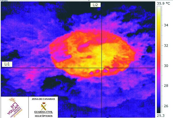
<a href="http://goo.gl/q8fhTe" target="_blank">FAQ?</a>
<a href="http://goo.gl/gYvZFq" target="_blank">Geel is een zonnige en vrolijke kleur, als hij tenminste enigszins warm is gekleurd en wat naar het oranje neigt</a>
<a href="http://goo.gl/gYvZFq" target="_blank">Geel is een zonnige en vrolijke kleur, als hij tenminste enigszins warm is gekleurd en wat naar het oranje neigt</a>
't is gewoon erg rustig
Wel 2 bevingen op/naast een bekende locatie - wel erg diep 11-12 KM diep.
1317605 17/02/2015 03:28:25 27.6262 -17.9670 11 2.5 4 S EL PINAR.IHI
1317646 17/02/2015 09:47:13 27.6254 -17.9631 12 2.0 4 S EL PINAR.IHI
[ Bericht 7% gewijzigd door bwt op 17-02-2015 15:57:05 ]
Wel 2 bevingen op/naast een bekende locatie - wel erg diep 11-12 KM diep.
1317605 17/02/2015 03:28:25 27.6262 -17.9670 11 2.5 4 S EL PINAR.IHI


1317646 17/02/2015 09:47:13 27.6254 -17.9631 12 2.0 4 S EL PINAR.IHI

[ Bericht 7% gewijzigd door bwt op 17-02-2015 15:57:05 ]
<a href="http://goo.gl/q8fhTe" target="_blank">FAQ?</a>
<a href="http://goo.gl/gYvZFq" target="_blank">Geel is een zonnige en vrolijke kleur, als hij tenminste enigszins warm is gekleurd en wat naar het oranje neigt</a>
<a href="http://goo.gl/gYvZFq" target="_blank">Geel is een zonnige en vrolijke kleur, als hij tenminste enigszins warm is gekleurd en wat naar het oranje neigt</a>
Ondertussen op een ander canarisch eiland:
twitter:teideano twitterde op vrijdag 20-02-2015 om 10:05:48 @geotenerife @geotinerfe #Teide #volcano this morning. Fumaroles are clearly visible. via @involcan http://t.co/adiaQHdfsl reageer retweet
 @geotenerife @
<a href="http://goo.gl/q8fhTe" target="_blank">FAQ?</a>
<a href="http://goo.gl/gYvZFq" target="_blank">Geel is een zonnige en vrolijke kleur, als hij tenminste enigszins warm is gekleurd en wat naar het oranje neigt</a>
<a href="http://goo.gl/gYvZFq" target="_blank">Geel is een zonnige en vrolijke kleur, als hij tenminste enigszins warm is gekleurd en wat naar het oranje neigt</a>
1323296 29/03/2015 05:48:18 27.6673 -18.0974 19 Sentido 3.1 4 SW EL PINAR.IHItwitter:sacanarias twitterde op zondag 29-03-2015 om 09:01:26 @teideano Temblor de 3.1 MBlg sentido esta madrugada al sudoeste de la isla de El Hierro bajo mar de Las Calmas http://t.co/vmHPoSvCYA reageer retweet


[ Bericht 9% gewijzigd door bwt op 29-03-2015 12:08:39 ]
<a href="http://goo.gl/q8fhTe" target="_blank">FAQ?</a>
<a href="http://goo.gl/gYvZFq" target="_blank">Geel is een zonnige en vrolijke kleur, als hij tenminste enigszins warm is gekleurd en wat naar het oranje neigt</a>
<a href="http://goo.gl/gYvZFq" target="_blank">Geel is een zonnige en vrolijke kleur, als hij tenminste enigszins warm is gekleurd en wat naar het oranje neigt</a>
En aan de rand van Gran Canaria:
1324452 07/04/2015 23:53:12 27.9655 -15.3880 23 Sentido 2.6 4 SE TELDE.IGC
1324452 07/04/2015 23:53:12 27.9655 -15.3880 23 Sentido 2.6 4 SE TELDE.IGC


<a href="http://goo.gl/q8fhTe" target="_blank">FAQ?</a>
<a href="http://goo.gl/gYvZFq" target="_blank">Geel is een zonnige en vrolijke kleur, als hij tenminste enigszins warm is gekleurd en wat naar het oranje neigt</a>
<a href="http://goo.gl/gYvZFq" target="_blank">Geel is een zonnige en vrolijke kleur, als hij tenminste enigszins warm is gekleurd en wat naar het oranje neigt</a>

iets hogere activiteit.
Zal vast weer zeer tijdelijk zijn.
1325141 14/04/2015 07:06:07 27.7103 -18.1861 25 1.8 mbLg W FRONTERA.IHI [+]
1325079 13/04/2015 21:28:24 27.7693 -18.1871 27 2.0 mbLg W FRONTERA.IHI [+]
1325075 13/04/2015 17:45:30 27.7934 -18.1872 26 1.7 mbLg W FRONTERA.IHI [+]
1325074 13/04/2015 16:25:46 27.8004 -18.1190 24 2.1 mbLg NW FRONTERA.IHI [+]
1325055 13/04/2015 15:12:01 27.6723 -18.0808 22 1.5 mbLg SW EL PINAR.IHI [+]
1325052 13/04/2015 14:22:00 27.8034 -18.1413 28 2.1 mbLg NW FRONTERA.IHI [+]
1324958 12/04/2015 16:20:03 27.7301 -17.9925 13 1.6 mbLg NW EL PINAR.IHI [+]
<a href="http://goo.gl/q8fhTe" target="_blank">FAQ?</a>
<a href="http://goo.gl/gYvZFq" target="_blank">Geel is een zonnige en vrolijke kleur, als hij tenminste enigszins warm is gekleurd en wat naar het oranje neigt</a>
<a href="http://goo.gl/gYvZFq" target="_blank">Geel is een zonnige en vrolijke kleur, als hij tenminste enigszins warm is gekleurd en wat naar het oranje neigt</a>
twitter:canariesnews twitterde op dinsdag 14-04-2015 om 11:07:27 New post El Hierro shakes again, view it in full here http://t.co/1di7yJ2p05 http://t.co/Khg3x9qmzG reageer retweet
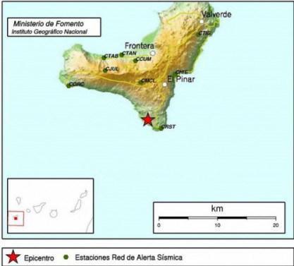
Ehhh,
Welke 2.7 hebben ze het eigenlijk over?
Vorige week is alleen de beving bij gran canaria geweest.
Ik kan hem nergens terug vinden.
In het nieuws bericht melden ze wel dat deze lichter is dan de recente 3+
gevonden:
1324423 07/04/2015 15:58:04 27.6650 -18.0441 11 2.7 4 SW EL PINAR.IHI

[ Bericht 14% gewijzigd door bwt op 14-04-2015 15:03:23 ]
<a href="http://goo.gl/q8fhTe" target="_blank">FAQ?</a>
<a href="http://goo.gl/gYvZFq" target="_blank">Geel is een zonnige en vrolijke kleur, als hij tenminste enigszins warm is gekleurd en wat naar het oranje neigt</a>
<a href="http://goo.gl/gYvZFq" target="_blank">Geel is een zonnige en vrolijke kleur, als hij tenminste enigszins warm is gekleurd en wat naar het oranje neigt</a>
Het is niet veel. Maar lijkt enigsinds te groeien qua hoeveelheid.
1325417 16/04/2015 06:39:42 27.7833 -18.1570 29 2.2 mbLg W FRONTERA.IHI [+]
1325410 16/04/2015 02:39:03 27.7634 -18.1526 28 2.0 mbLg W FRONTERA.IHI [+]
1325362 15/04/2015 10:32:19 27.7892 -18.1552 26 1.9 mbLg W FRONTERA.IHI [+]
1325286 14/04/2015 23:41:19 27.8977 -18.0733 1.8 mbLg NW FRONTERA.IHI [+]
1325216 14/04/2015 10:33:06 27.7505 -18.1740 31 2.0 mbLg W FRONTERA.IHI [+]
1325141 14/04/2015 07:06:07 27.7103 -18.1861 25 1.8 mbLg W FRONTERA.IHI [+]
<a href="http://goo.gl/q8fhTe" target="_blank">FAQ?</a>
<a href="http://goo.gl/gYvZFq" target="_blank">Geel is een zonnige en vrolijke kleur, als hij tenminste enigszins warm is gekleurd en wat naar het oranje neigt</a>
<a href="http://goo.gl/gYvZFq" target="_blank">Geel is een zonnige en vrolijke kleur, als hij tenminste enigszins warm is gekleurd en wat naar het oranje neigt</a>
En bevingen op Tenerife:
1326966 28/04/2015 07:08:22 28.3388 -16.4202 29 2.1 mbLg W ARAFO.ITF [+]
1326956 28/04/2015 06:28:00 28.3356 -16.4114 30 2.2 mbLg SE ARAFO.ITF [+]
1326951 28/04/2015 06:21:59 28.3332 -16.4044 30 1.9 mbLg SE ARAFO.ITF [+]
1326980 28/04/2015 06:19:14 28.3392 -16.4127 30 1.5 mbLg E ARAFO.ITF [+]
1326947 28/04/2015 06:14:08 28.3360 -16.4014 30 1.7 mbLg E ARAFO.ITF [+]
1326954 28/04/2015 04:55:44 28.3299 -16.3941 30 1.5 mbLg NE GÜÍMAR.ITF [+]
twitter:involcan twitterde op dinsdag 28-04-2015 om 10:53:25 Enjambre sísmico de la isla de #tenerife en la zona del Valle de Güimar. Seismic swarm at the Güimar Valley http://t.co/IYnQ8pbAdw reageer retweet
 Enjambre sísmico de la isla de
1326966 28/04/2015 07:08:22 28.3388 -16.4202 29 2.1 mbLg W ARAFO.ITF [+]
1326956 28/04/2015 06:28:00 28.3356 -16.4114 30 2.2 mbLg SE ARAFO.ITF [+]
1326951 28/04/2015 06:21:59 28.3332 -16.4044 30 1.9 mbLg SE ARAFO.ITF [+]
1326980 28/04/2015 06:19:14 28.3392 -16.4127 30 1.5 mbLg E ARAFO.ITF [+]
1326947 28/04/2015 06:14:08 28.3360 -16.4014 30 1.7 mbLg E ARAFO.ITF [+]
1326954 28/04/2015 04:55:44 28.3299 -16.3941 30 1.5 mbLg NE GÜÍMAR.ITF [+]
<a href="http://goo.gl/q8fhTe" target="_blank">FAQ?</a>
<a href="http://goo.gl/gYvZFq" target="_blank">Geel is een zonnige en vrolijke kleur, als hij tenminste enigszins warm is gekleurd en wat naar het oranje neigt</a>
<a href="http://goo.gl/gYvZFq" target="_blank">Geel is een zonnige en vrolijke kleur, als hij tenminste enigszins warm is gekleurd en wat naar het oranje neigt</a>
Bevingen zijn er met grote regelmaat.quote:bericht van tyron
Dat er nu een kleine swarm is geweest betekend dat de "stress" in het gesteente in meerdere kleine bevingen is ontladen ipv 1 enkele.
(quote er in zorgt voor meer duidelijkheid bij volgende posten....)
[ Bericht 18% gewijzigd door bwt op 28-04-2015 13:40:30 ]
<a href="http://goo.gl/q8fhTe" target="_blank">FAQ?</a>
<a href="http://goo.gl/gYvZFq" target="_blank">Geel is een zonnige en vrolijke kleur, als hij tenminste enigszins warm is gekleurd en wat naar het oranje neigt</a>
<a href="http://goo.gl/gYvZFq" target="_blank">Geel is een zonnige en vrolijke kleur, als hij tenminste enigszins warm is gekleurd en wat naar het oranje neigt</a>
wat is eigenlijk de oorzaak van de bevingen op de Canarische eilanden? De vulkanische activiteit?
In Baden-Badener Badeseen kann man Baden-Badener baden sehen.
De canarische eilanden zijn allemaal vulkanische eilanden.quote:
wat is eigenlijk de oorzaak van de bevingen op de Canarische eilanden? De vulkanische activiteit?
De meningen verschillen of dat het wel of niet komt door een vulkanische hotspot.
Op vrijwel alle eilanden kun je nog met regelmaat iets van activiteit terug zien Zie een paar posts hier voor (foto van de hoogste berg van Spanje "el Teide" waarbij er "Fumaroles" gespot zijn aan de top.
<a href="http://goo.gl/q8fhTe" target="_blank">FAQ?</a>
<a href="http://goo.gl/gYvZFq" target="_blank">Geel is een zonnige en vrolijke kleur, als hij tenminste enigszins warm is gekleurd en wat naar het oranje neigt</a>
<a href="http://goo.gl/gYvZFq" target="_blank">Geel is een zonnige en vrolijke kleur, als hij tenminste enigszins warm is gekleurd en wat naar het oranje neigt</a>
Wanneer kwam er dan rook uit de Teide? Is alweer een tijd geleden of niet?quote:
[..]
De canarische eilanden zijn allemaal vulkanische eilanden.
De meningen verschillen of dat het wel of niet komt door een vulkanische hotspot.
Op vrijwel alle eilanden kun je nog met regelmaat iets van activiteit terug zien Zie een paar posts hier voor (foto van de hoogste berg van Spanje "el Teide" waarbij er "Fumaroles" gespot zijn aan de top.
Check mijn linkjes in de postquote:
[..]
Wanneer kwam er dan rook uit de Teide? Is alweer een tijd geleden of niet?
Niet veel. Zelden eigenlijk.quote:
Laatste tijd zijn er wel wat meer bevingen geweest tussen Gran Canaria en Tenerife.
Maar niet dat ik denk dat er iets achter gezocht moet worden.
Gok dat het stress in het gesteente zal zijn.
<a href="http://goo.gl/q8fhTe" target="_blank">FAQ?</a>
<a href="http://goo.gl/gYvZFq" target="_blank">Geel is een zonnige en vrolijke kleur, als hij tenminste enigszins warm is gekleurd en wat naar het oranje neigt</a>
<a href="http://goo.gl/gYvZFq" target="_blank">Geel is een zonnige en vrolijke kleur, als hij tenminste enigszins warm is gekleurd en wat naar het oranje neigt</a>
En zo af en toe komt er nog 1 langs die gevoeld wordt.
1327493 01/05/2015 21:45:08 27.7178 -17.9541 13 Sentido 2.7 4 NE EL PINAR.IHI
1327493 01/05/2015 21:45:08 27.7178 -17.9541 13 Sentido 2.7 4 NE EL PINAR.IHI

<a href="http://goo.gl/q8fhTe" target="_blank">FAQ?</a>
<a href="http://goo.gl/gYvZFq" target="_blank">Geel is een zonnige en vrolijke kleur, als hij tenminste enigszins warm is gekleurd en wat naar het oranje neigt</a>
<a href="http://goo.gl/gYvZFq" target="_blank">Geel is een zonnige en vrolijke kleur, als hij tenminste enigszins warm is gekleurd en wat naar het oranje neigt</a>
En een beetje info over de canarische eilanden die onder water liggen.
En er zou een lichte ondiepe beving onder de Teide geweest zijn.
Nog niets van gezien op grafiek en of lijsten
De laatste bekende is van 1-6-2015
1332352 01/06/2015 22:34:38 28.3279 -16.3896 30 2.8 4 NE GÜÍMAR.ITF
twitter:GeoTenerife twitterde op dinsdag 02-06-2015 om 19:32:34 Older string of Canary Islands below sea date back 100m years, say IGME via @cienciacanaria. http://t.co/8pYR6eDOov http://t.co/kcLdJeOSi5 reageer retweet

En er zou een lichte ondiepe beving onder de Teide geweest zijn.
twitter:sacanarias twitterde op woensdag 03-06-2015 om 07:18:30 @involcan De nuevo un pequeño temblor muy somero bajo el Teide en la isla de Tenerife en esta madrugada. http://t.co/JoDGb2dvq0 reageer retweet

Nog niets van gezien op grafiek en of lijsten
De laatste bekende is van 1-6-2015
1332352 01/06/2015 22:34:38 28.3279 -16.3896 30 2.8 4 NE GÜÍMAR.ITF

<a href="http://goo.gl/q8fhTe" target="_blank">FAQ?</a>
<a href="http://goo.gl/gYvZFq" target="_blank">Geel is een zonnige en vrolijke kleur, als hij tenminste enigszins warm is gekleurd en wat naar het oranje neigt</a>
<a href="http://goo.gl/gYvZFq" target="_blank">Geel is een zonnige en vrolijke kleur, als hij tenminste enigszins warm is gekleurd en wat naar het oranje neigt</a>
1 enkele beving:
1334294 14/06/2015 00:05:13 27.6810 -18.0838 18 2.6 4 W EL PINAR.IHI
Maar het is drukker rond de rest van de eilanden
1334296 14/06/2015 05:35:27 28.9365 -18.2686 89 1.8 mb ATLÁNTICO-CANARIAS [+]
1334291 13/06/2015 15:20:58 27.9537 -16.1771 1.5 mbLg ATLÁNTICO-CANARIAS [+]
1334287 13/06/2015 15:18:02 27.9981 -16.1713 30 2.7 mbLg ATLÁNTICO-CANARIAS [+]
1333793 10/06/2015 12:47:24 28.5809 -16.4768 1.9 mbLg NW EL SAUZAL.ITF [+]
1333165 07/06/2015 06:01:29 28.1616 -16.8711 8 1.8 mbLg SW GUÍA DE ISORA.ITF [+]
1333112 05/06/2015 17:18:52 28.0915 -16.1775 22 2.1 mbLg ATLÁNTICO-CANARIAS [+]
1334294 14/06/2015 00:05:13 27.6810 -18.0838 18 2.6 4 W EL PINAR.IHI

Maar het is drukker rond de rest van de eilanden
1334296 14/06/2015 05:35:27 28.9365 -18.2686 89 1.8 mb ATLÁNTICO-CANARIAS [+]
1334291 13/06/2015 15:20:58 27.9537 -16.1771 1.5 mbLg ATLÁNTICO-CANARIAS [+]
1334287 13/06/2015 15:18:02 27.9981 -16.1713 30 2.7 mbLg ATLÁNTICO-CANARIAS [+]
1333793 10/06/2015 12:47:24 28.5809 -16.4768 1.9 mbLg NW EL SAUZAL.ITF [+]
1333165 07/06/2015 06:01:29 28.1616 -16.8711 8 1.8 mbLg SW GUÍA DE ISORA.ITF [+]
1333112 05/06/2015 17:18:52 28.0915 -16.1775 22 2.1 mbLg ATLÁNTICO-CANARIAS [+]
<a href="http://goo.gl/q8fhTe" target="_blank">FAQ?</a>
<a href="http://goo.gl/gYvZFq" target="_blank">Geel is een zonnige en vrolijke kleur, als hij tenminste enigszins warm is gekleurd en wat naar het oranje neigt</a>
<a href="http://goo.gl/gYvZFq" target="_blank">Geel is een zonnige en vrolijke kleur, als hij tenminste enigszins warm is gekleurd en wat naar het oranje neigt</a>
La Palma - caldera de taburiente
https://twitter.com/HRobi(...)396590948352/video/1
En check de video in de tweettwitter:HRobinson1502 twitterde op zondag 14-06-2015 om 18:11:37 #BubblingSpring #DissolvedGasses Caldera de Taburienta @GeoTenerife @GESUofG @UofGSciEngGrads http://t.co/Yz8TiYQAwO reageer retweet

https://twitter.com/HRobi(...)396590948352/video/1
<a href="http://goo.gl/q8fhTe" target="_blank">FAQ?</a>
<a href="http://goo.gl/gYvZFq" target="_blank">Geel is een zonnige en vrolijke kleur, als hij tenminste enigszins warm is gekleurd en wat naar het oranje neigt</a>
<a href="http://goo.gl/gYvZFq" target="_blank">Geel is een zonnige en vrolijke kleur, als hij tenminste enigszins warm is gekleurd en wat naar het oranje neigt</a>
Kokend water?quote:
La Palma - caldera de taburienteEn check de video in de tweettwitter:HRobinson1502 twitterde op zondag 14-06-2015 om 18:11:37 #BubblingSpring #DissolvedGasses Caldera de Taburienta @GeoTenerife @GESUofG @UofGSciEngGrads http://t.co/Yz8TiYQAwO reageer retweet
https://twitter.com/HRobi(...)396590948352/video/1
#DissolvedGasses staat erbij, en ik zie geen stoomquote:
In Baden-Badener Badeseen kann man Baden-Badener baden sehen.
't is Lekker rustig
1337327 17/07/2015 18:08:45 27.7454 -18.0184 10 2.3 mbLg SW FRONTERA.IHI [+]
1337177 15/07/2015 20:26:22 27.7254 -18.0041 17 1.7 mbLg NW EL PINAR.IHI [+]
1336931 11/07/2015 14:40:22 27.9011 -18.2165 2.3 mbLg NW FRONTERA.IHI [+]
1337327 17/07/2015 18:08:45 27.7454 -18.0184 10 2.3 mbLg SW FRONTERA.IHI [+]
1337177 15/07/2015 20:26:22 27.7254 -18.0041 17 1.7 mbLg NW EL PINAR.IHI [+]
1336931 11/07/2015 14:40:22 27.9011 -18.2165 2.3 mbLg NW FRONTERA.IHI [+]
<a href="http://goo.gl/q8fhTe" target="_blank">FAQ?</a>
<a href="http://goo.gl/gYvZFq" target="_blank">Geel is een zonnige en vrolijke kleur, als hij tenminste enigszins warm is gekleurd en wat naar het oranje neigt</a>
<a href="http://goo.gl/gYvZFq" target="_blank">Geel is een zonnige en vrolijke kleur, als hij tenminste enigszins warm is gekleurd en wat naar het oranje neigt</a>
Ben ik ff druk bezig zijn er een paar bevingen die gevoeld zijn.
tussen tenerife en gran canaria
1338076 28/07/2015 00:13:50 28.0947 -16.2329 33 I-II 3.2 4 ATLÁNTICO-CANARIAS
En op el Hierro
1338237 29/07/2015 17:38:39 27.7207 -17.9742 2 II 2.1 4 NE EL PINAR.IHI
tussen tenerife en gran canaria
1338076 28/07/2015 00:13:50 28.0947 -16.2329 33 I-II 3.2 4 ATLÁNTICO-CANARIAS

En op el Hierro
1338237 29/07/2015 17:38:39 27.7207 -17.9742 2 II 2.1 4 NE EL PINAR.IHI

<a href="http://goo.gl/q8fhTe" target="_blank">FAQ?</a>
<a href="http://goo.gl/gYvZFq" target="_blank">Geel is een zonnige en vrolijke kleur, als hij tenminste enigszins warm is gekleurd en wat naar het oranje neigt</a>
<a href="http://goo.gl/gYvZFq" target="_blank">Geel is een zonnige en vrolijke kleur, als hij tenminste enigszins warm is gekleurd en wat naar het oranje neigt</a>
Het is nu een keer erg actief op Tenerife
Report: (google translate)
twitter:involcan twitterde op maandag 03-10-2016 om 02:04:10 Son ya 98 los sismos localizados en el enjambre sísmico del día de hoy en Tenerife https://t.co/n0kGVPkODR reageer retweet
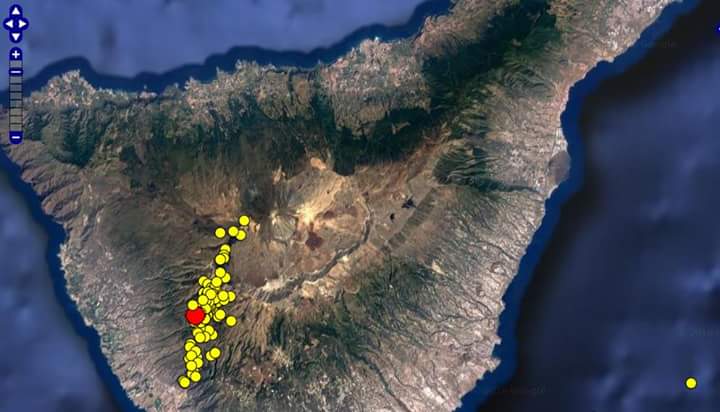
Report: (google translate)
quote:Report on the seismic swarm October 2
After the passage of the night and the absence of earthquakes, it can terminate the episode seismic swarm registered yesterday on the island of Tenerife. Seismic swarm that responds to the common activity of an active volcano, but in the case of the island of Tenerife are rare, which requires monitoring.
Recall that a seismic swarm is the occurrence of a set of seismic events in a specific area over a relatively short period of time without there being associated with a major earthquake.
The rest of analysis of data from the INVOLCAN, at this time the report is as follows:
GPS stations : No deformation is attributable to this episode of anomalous seismicity. This lack of deformation may be because there is an injection of magma underground, which would make this episode of seismicity could be related to the hydrothermal system of the volcano, and not with a magmatic intrusion. We continue analyzing and observing the signals received during the day.
Gases : INVOLCAN Two teams are already in the area for a campaign swarm estimation (not visible) diffuse emission of carbon dioxide. In this regard it should be noted that the INVOLCAN 2015 registered a relative increase in CO2 emissions compared to previous years in the Northwest Ridge, without these values become extremely high.
Although this episode may be classified as abnormal, should not be cause for social alarm, because in any case there is a sequence of "action-reaction". A large number of seismic swarms appear and disappear without bringing other activity, but they are a clear example of the dynamics of an active system like Tenerife.
We will continue producing reports during the day.
<a href="http://goo.gl/q8fhTe" target="_blank">FAQ?</a>
<a href="http://goo.gl/gYvZFq" target="_blank">Geel is een zonnige en vrolijke kleur, als hij tenminste enigszins warm is gekleurd en wat naar het oranje neigt</a>
<a href="http://goo.gl/gYvZFq" target="_blank">Geel is een zonnige en vrolijke kleur, als hij tenminste enigszins warm is gekleurd en wat naar het oranje neigt</a>
Inderdaad
Niet veel zinnigs van te maken
Niet veel zinnigs van te maken
twitter:involcan twitterde op maandag 03-10-2016 om 17:21:18 Así ha evolucionado la sismicidad registrada en Tenerife y alrededores desde enero de 2012. https://t.co/xMp8uDG7Oo reageer retweet

<a href="http://goo.gl/q8fhTe" target="_blank">FAQ?</a>
<a href="http://goo.gl/gYvZFq" target="_blank">Geel is een zonnige en vrolijke kleur, als hij tenminste enigszins warm is gekleurd en wat naar het oranje neigt</a>
<a href="http://goo.gl/gYvZFq" target="_blank">Geel is een zonnige en vrolijke kleur, als hij tenminste enigszins warm is gekleurd en wat naar het oranje neigt</a>
Denk dat dat wel een hele mooie omschijving is.
<a href="http://goo.gl/q8fhTe" target="_blank">FAQ?</a>
<a href="http://goo.gl/gYvZFq" target="_blank">Geel is een zonnige en vrolijke kleur, als hij tenminste enigszins warm is gekleurd en wat naar het oranje neigt</a>
<a href="http://goo.gl/gYvZFq" target="_blank">Geel is een zonnige en vrolijke kleur, als hij tenminste enigszins warm is gekleurd en wat naar het oranje neigt</a>
quote:bron
IGN has located far 96 events between 14:30 pm and 19:00 pm (local time) yesterday, October 2, whose epicentral interim solutions are placed in an area between the towns of Guia de Isora , Vilaflor and Adeje. The maximum recorded magnitude of the swarm is 1 mbLg. No anomalous values recorded on the island of Tenerife in the deformation monitoring stations and geochemistry. At the moment it is reviewing and verifying the activity localized nature.
To track the activity in Tenerife is available page

http://www.ign.es/ign/res(...)/TE_SIS_eventos.html
--------------
bron
quote:Analysis Report seismic signals swarm of October 2
REPORT ON SEISMIC SWARM OF OCTOBER 02
Below are the most significant findings of the report prepared by Dr. Luca D'Auria, Head of the Functional Unit of Volcanology Volcanic Seismology Institute of the Canary Islands (INVOLCAN) on the seismic swarm Sunday October 2, 2016 are broken down into registered the island of Tenerife by the National seismic Network after thorough analysis of seismic signals.
• The spectral characteristics, distributions between events and magnitude that clearly reflect events swarm of 2 October 2016 can be reasonably classified as seismic-volcanic events long period.
• The estimated number of seismic events reported in the national seismic catalog could be underestimated. An estimate based on the spectrograms reflects the number of seismic events could have been higher than 400 events.
• After 17:58 hours individual seismic events merge into a continuous stream of seismic events lasting at least until 19:35 hours.
• The hipocentral distribution (distribution of outbreaks or depths of seismic events) is likely to be a "device" due to the geometry of the sparse seismic network of the IGN and the small amplitude of events to evaluate these processes. Seismic events are more likely clustered in a small volume.
• The depths of seismic events should be reviewed, since it could be significantly more superficial than those reported by IGN.
• The spectra shows similarities with the spectra of long-period events and tremor observed in Tenerife during the crisis sismovolcánico 2004. They also share characteristics observed in other active volcanoes in the world.
Again, we must insist on the absence of a sequence of "action-reaction" to this phenomenon as well as the need to avoid falling into unfounded alarms. The appearance of these phenomena can be as abrupt as its disappearance, without thereby an activity otherwise occur. The INVOLCAN continue to conduct relevant research for further communication depending on the signals that go recording.
This entry was posted in News on October 4, 2016.
[ Bericht 27% gewijzigd door bwt op 04-10-2016 13:18:05 ]
<a href="http://goo.gl/q8fhTe" target="_blank">FAQ?</a>
<a href="http://goo.gl/gYvZFq" target="_blank">Geel is een zonnige en vrolijke kleur, als hij tenminste enigszins warm is gekleurd en wat naar het oranje neigt</a>
<a href="http://goo.gl/gYvZFq" target="_blank">Geel is een zonnige en vrolijke kleur, als hij tenminste enigszins warm is gekleurd en wat naar het oranje neigt</a>
quote:Canary Islands volcano blow up could be as EXPLOSIVE as monster Iceland eruption
THE huge volcano eruption that threatens to wreak havoc across the Canary Islands could be as bad as the notorious Iceland blow up, experts have warned.
If Mount Tiede in Tenerife explodes, it will be on a similar scale to the Eyjafallajokull eruption in 2010.
Experts Harri Geiger and Abigail Baker, from Sweden's University of Uppsala, also revealed watching the magma migration – where the hot lava develops in the chamber – is key to detecting any signs of an explosion.
Mr Geiger said: "The emergence of shallow pockets of magma probably plays an important role in the eruptive style of the volcano and therefore should be considered in order to mitigate risks.
"We believe that these findings have implications for volcanoes in Iceland, Cape Verde and the Canary islands.
"Magma is stored at the bottom of the crust and there are also shallow magma chambers in the upper part of the crust.
"These shallow cavities seem to migrate in times of volcanic inactivity and can play a crucial role in the eruption process.
"There are also migrations to shallower waters where magma increases its explosive potential.
"A longer time between eruptions increases the likelihood of the next eruption to be more explosive, very similar to the eruption of Eyjafjallajökull in Iceland in 2010."
As many as 5,000 passenger flights were affected when the monstrous Icelandic volcano erupted.
Fears grew earlier this year that an Icelandic volcano was set to blow its top.
Ms Baker added: "Our message to the monitoring team is that they should focus on the seismic signals of magma migration from about 20 kilometres deep because such signals are very likely to precede eruptions.”
This comes as the Canary Islands government called for an emergency meeting when 100 quakes shook the island of Tenerife in just four hours.
Spanish geologists feared the 12,000ft volcano was on the verge of exploding.
The Volcanology Institute of the Canary Islands (Involcan) deployed a team on site who described the "seismic swarm" of carbon dioxide in the atmosphere as "abnormal for the area".
Alberto Bernabé, Tourism Minister for the Tenerife Island Government, said: "The entities in Spain and the Canary Islands which are responsible for monitoring the volcanic activity of the archipelago have pointed out that the series of micro earthquakes recorded on Sunday October 2, indiscernible by the population due to its low magnitude, do not entail any risks to residents and the tourists who are spending their holidays on the island.
The National Geographic Institute (IGN) has informed that the tremors were not due to any seismic activity but to low intensity tectonic movements.
"Furthermore, the Involcan has specified that the seismic activity could be related to the hydrothermal system of the volcano, and not to a magmatic intrusion, which, in any case, would be a 'common situation which should not frighten anybody'."
It last blew up in 1909 but seismic activity began to sizzle when a rift opened in the north-east side of the volcano in 2003.
Woepsquote:
 Op
Op Tja, geologisch gezien in wat er op tussen 1730 en 1736 Lanzarote gebeurde vanmorgen vroeg geweest.
In Baden-Badener Badeseen kann man Baden-Badener baden sehen.
euh...van deze post snap ik ff nietsquote:
[..]
Woeps
Tja, geologisch gezien in wat er op tussen 1730 en 1736 Lanzarote gebeurde vanmorgen vroeg geweest.
Bijna 300 jaar geleden vond een enorme vulkaanuitbarsting daar plaats.quote:
[..]
euh...van deze post snap ik ff niets
In Baden-Badener Badeseen kann man Baden-Badener baden sehen.
Ja dat wist ik maar dan nog snapte ik je zin nietquote:
[..]
Bijna 300 jaar geleden vond een enorme vulkaanuitbarsting daar plaats.
Zelfde hotspot, is geologisch gezien pas geleden, zou dus zomaar nog een keer kunnen gebeurenquote:
[..]
Ja dat wist ik maar dan nog snapte ik je zin niet
In Baden-Badener Badeseen kann man Baden-Badener baden sehen.
Dat zou me niets verbazen inderdaad gezien de historie en de geologie van die eilandketenquote:
[..]
Zelfde hotspot, is geologisch gezien pas geleden, zou dus zomaar nog een keer kunnen gebeuren
Maar
Daar wordt ik niet wijs uitquote:Woeps
Tja, geologisch gezien in wat er op tussen 1730 en 1736 Lanzarote gebeurde vanmorgen vroeg geweest.
Op een geologische tijdschaal is het nog geeneens gisteren.quote:
[..]
Dat zou me niets verbazen inderdaad gezien de historie en de geologie van die eilandketen
Maar
[..]
Daar wordt ik niet wijs uit
In Baden-Badener Badeseen kann man Baden-Badener baden sehen.
twitter:teideano twitterde op vrijdag 10-02-2017 om 22:58:41 10 earthquakes this week at #Tenerife island. The new info chart is already available. https://t.co/vLjLEk9CbG reageer retweet
Dat zou hee nasty zijn idd .. Maar de natuur houdt verder geen rekening met ons..quote:
[..]
Moest ff goed lezen om te zien dat Tiede niet een Krakatoa gaat doen.

Dat gebeurt als La Palma de plomp in zakt.quote:Op zaterdag 11 februari 2017 23:08 schreef Gutz het volgende:
Ff goed schudden daar en ze hebben in New York natte voetjes