WKN Weer, Klimaat en Natuurrampen
Lees alles over het onstuimige weer op onze planeet, volg orkanen en tornado's, zie hoe vulkanen uitbarsten en hoe Moeder Aarde beeft bij een aardbeving. Alles over de verwoestende kracht van onze planeet en tal van andere natuurverschijnselen.


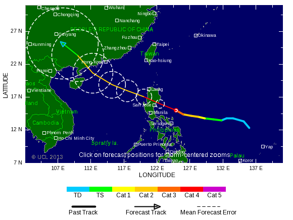
De storm in de west pacific heeft de naam UTOR gekregen en trekt richting de Filipijnen. TSR laat de tyfoon nu over het noordelijke deel van de Filipijnen trekken en daarna richting China en Vietnam.


http://www.euronews.com/2(...)kes-the-philippines/quote:The most powerful typhoon to hit the Philippines this year has triggered floods and landslides, smashed hundreds of homes and disrupted power and communication links.
Typhoon Utor, packing winds of 150 kilometres per hour near its centre and gusts of up to 185 kph, made landfall on the northern island of Luzon.
The national disaster agency said a man clearing a clogged drain was killed when a landslide buried him in mountainous Benguet province and dozens of people – mostly fishermen – are missing.
The typhoon has also badly damaged rice, corn and coconut crops.
The coastal town of Casiguran in Aurora province, 343 kilometres northeast of the capital Manila, suffered the worst damage, after the typhoon set off landslides that blocked its only access road.
“About 90 percent of our agriculture was destroyed or damaged,” Aurora governor Gerardo Noveras told ANC television, adding that the full extent of damage was still unknown.
Losing strength the typhoon moved out over the South China Sea and was expected to hit about 300 kilometres southwest of Hong Kong.
On average 20 typhoons hit the Philippines every year.
http://newsinfo.inquirer.(...)ssing-in-philippinesquote:MANILA, Philippines—A powerful typhoon battered the northern Philippines on Monday, toppling power lines and dumping heavy rain across cities and food-growing plains. The storm left at least two people dead and 44 missing.
Typhoon Utor (local name: Labuyo), described as the strongest globally this year, slammed ashore in mountainous eastern Aurora province with sustained winds of 175 kilometers (109 miles) per hour and gusts of up to 210 kph (130 mph).
Footage from ABS-CBN TV network showed a woman swept away by a raging river in neighboring Isabela province. The woman waved her hands for help as she struggled to hang on to debris while being buffeted by huge waves in the muddy waters. It was not known what happened to her.
“She has not been found, so she is missing,” said Norma Talosig, a regional civil defense director. She said the woman lived alone in a low-lying area and had refused to be evacuated.
Talosig said that in northern Nueva Vizcaya province, a 53-year-old farmer drowned while trying to rescue his water buffalo from a swift-moving flood. The animal survived.
In mountainous Benguet province, a 22-year-old man died on the way to a hospital after he was pulled from a landslide that hit a canal he was clearing, said regional civil defense official Andrew Alex Uy.
8-foot waves
The typhoon triggered waves of up to 2.5 meters (eight feet) and left scores of fishermen missing.
In northern Pangasinan province, 25 fishermen on three boats failed to return home, said provincial police spokesman Senior Inspector Ryan Manongdo.
Eighteen other fishermen from the eastern provinces of Catanduanes and Camarines Norte also were unaccounted for. Authorities were hoping they took shelter in coves and nearby islands, said Office of Civil Defense regional director Bernardo Alejandro IV.
“I hope they’re just waiting for the typhoon to pass and will show up as soon as the weather clears,” he said. A higher number of missing had been reported earlier, but some of the fishermen have returned home.
As of late Monday, Utor picked up speed as it continued to move away from the country. Government forecaster Joey Figuracion said the typhoon was 230 kilometers (140 miles) northwest of northern Ilocos Sur province’s coast, and moving to the northwest.
It was forecast to reach southern China on Wednesday.
Office of Civil Defense Administrator Eduardo del Rosario said 1,895 people from three regions had to be evacuated to shelters, with 673 houses damaged.
Utor, the Marshellese word for a squall line, was the 12th of about 20 storms and typhoons expected to lash the Philippines this year.—Teresa Cerojano with Joeal Calupitan, Hrvoje Hranjski and Jim Gomez

Het is nu alweer een cat 3 en gaat weer een cat 4 worden. Nu is China aan de beurt.quote:Op maandag 12 augustus 2013 12:32 schreef Frutsel het volgende:
[..]
Landfall cat.4...
dan denk je: Big Trouble...

[ Bericht 8% gewijzigd door #ANONIEM op 13-08-2013 07:27:51 ]
Vier doden en 36.000 ontheemden na doortocht tyfoon Utor op Filipijnen
Op de Filipijnen zijn na de doortocht van tyfoon Utor vier doden geteld. Meer dan 36.000 Filipino's moesten hun woonst verlaten, zo liet de civiele bescherming weten.
Met rukwinden tot 160 kilometer per uur (en uitschieters van zelfs 195 km/u) was de wervelstorm ongemeen krachtig. Elf mensen, onder wie negen vissers, zijn nog vermist. De totale schade die Utor op de Filipijnen heeft aangericht, wordt geschat op 1,2 miljoen euro.
De tyfoon is nu onderweg naar Zuidoost-China.
http://www.hln.be/hln/nl/(...)-op-Filipijnen.dhtml
Canadese model komt met een groot systeem voor de kust van Texas.
Het lijkt er op dat het op langere termijn drukker gaat worden boven de atlantische oceaan.
Het lijkt er op dat het op langere termijn drukker gaat worden boven de atlantische oceaan.


Intensiteit lijkt per run ook toe te nemen. Landfall schuift langzaam aan westelijker, nu dus op NW van de GOM (texas/mexico) waar het gisteren meer N van de GOM (new orleans) was.

Nu al een groot deel van de Caribische zee gevuld met onweersbuien. Dit gebied trekt de Golf van Mexico binnen. De vraag blijft waar het heen gaat. GFS zegt meer richting Florida en CMC gaat voor Mexico/Texas.


Wat gaat dit worden? Systeem duikt via Mexico de Golf van Mexico in en daarna richting de staat Louisiana..

Ziet er op de SSD in ieder geval een stuk beter als vanochtend. Het is afwachten wat het systeem gaat doen zodra hij over de Yucatan komt.
Dat is afwachten.. Geen model die duidelijkheid geeft.quote:
Ziet er op de SSD in ieder geval een stuk beter als vanochtend. Het is afwachten wat het systeem gaat doen zodra hij over de Yucatan komt.
Ziet er nu wel indrukwekkend uit.