WKN Weer, Klimaat en Natuurrampen
Lees alles over het onstuimige weer op onze planeet, volg orkanen en tornado's, zie hoe vulkanen uitbarsten en hoe Moeder Aarde beeft bij een aardbeving. Alles over de verwoestende kracht van onze planeet en tal van andere natuurverschijnselen.


Nog ver weg. De eerste storm in de Pacific (oost)??
[ Bericht 0% gewijzigd door #ANONIEM op 06-05-2012 22:07:06 ]

[ Bericht 0% gewijzigd door #ANONIEM op 06-05-2012 22:07:06 ]

quote:Signs of tropical activity in Caribbean later this month
While an area is being watched in the Eastern Pacific for tropical development early this week, the Caribbean could show some signs of life later this month.
A broad area of low pressure is expected to form very slowly in the area around Central America and the western Caribbean.
Folks living in the region around Central America to Cuba, Jamaica, The Bahamas and South Florida should not be overly concerned at this point.
Chances are this system will never become strong or well organized.
However, it could spread a swath of downpours over the region. Even a weak, disorganized system can produce clusters of heavy, gusty thunderstorms, which would be a problem for pleasure boaters, beach goers and fishing interests.
According to Tropical Weather Expert Dan Kottlowski, "This is likely to end up like about a dozen or so systems during the season that do not reach tropical storm status."
"The system will not have any tropical waves coming in from the east to give it a jump start, but a non-tropical feature arriving from the northwest next week may just help create a broad area of low pressure or gyre," Kottlowski added.
We are in a neutral phase of the El Nino Southern Oscillation (ENSO). This is the fluctuation of sea surface temperatures in the tropical Pacific Ocean.
When the tropical Pacific surface water is warmer than average, it is considered an El Nino, When it is cooler than average it is considered La Nina.
During an El Nino, (warm water phase) air tends to rise over the tropical Pacific Ocean, supporting the formation of tropical cyclones. Correspondingly, air tends to sink over the Atlantic, working against the formation of tropical cyclones.
It tends to work just the opposite during a La Nina phase of the ENSO.
"Since we are in a neutral phase, we should not expect any substantial interference or gain at this point of the season by the ENSO," Kottlowski said.
The start of the Atlantic hurricane season is not until June 1, but tropical storms have formed as early as January and February with hurricanes as early as March.

80% inmiddels voor de invest daarroquote:Op zondag 6 mei 2012 22:06 schreef aloa het volgende:
Nog ver weg. De eerste storm in de Pacific (oost)??
quote:Azoren low pressure system unlikely to develop
The hybrid low pressure system with both tropical and extratropical characteristics that formed Saturday over the far Eastern Atlantic, about 450 miles southwest of the southern Azores Islands (Invest 92L), has weakened considerably, and is unlikely to become Subtropical Storm Alberto. Wind shear has increased to a very high 25 - 40 knots over 92L today, causing a marked deterioration of the heavy thunderstorm activity. Also not helping is the fact 92L is over cold ocean waters of 68°F (20°C.) This is well below the 26°C usually needed for a tropical storm to form. Satellite estimates of 92L's winds were 35 mph at 7:45 am EDT Monday, according to NOAA/NESDIS. NHC estimated that 92L had top winds of 40 mph at 8 am EDT Monday, down 10 mph from Saturday's peak. Wind shear is expected to remain very high and water temperatures will cool as 92L moves northeast towards the Azores Islands on Tuesday and Wednesday, and the chances of the storm developing into a subtropical or tropical cyclone are near zero percent.

En ook al bij de oostkust...is dit een voorbode van wat nog gaat komen?quote:Op zaterdag 19 mei 2012 23:39 schreef SoldMayor het volgende:
Zo kijk dit dan eens.
[ afbeelding ]
Vroege start dus van het seizoen.
Wie weet.quote:Op zondag 20 mei 2012 09:29 schreef aloa het volgende:
[..]
En ook al bij de oostkust...is dit een voorbode van wat nog gaat komen?
Het begint vroeg en meteen ook opvallend druk.
In de oost pacific nu al storm nummer 2 van het seizoen.
Opvallende koers, en opvallend sterk voor deze tijd. Mogelijk gevaar.
Veder is Alberto wat aan het dolle voor de oost kust van Amerika.
En 03W is er ook al:
In de oost pacific nu al storm nummer 2 van het seizoen.

Opvallende koers, en opvallend sterk voor deze tijd. Mogelijk gevaar.
Veder is Alberto wat aan het dolle voor de oost kust van Amerika.
En 03W is er ook al:

Oost Pacific seizoen begint begin mei dus dat is nog niet zo uitzonderlijk vind ik.
Ziet er wel naar uit dat "Bud" een orkaan wordt
Ziet er wel naar uit dat "Bud" een orkaan wordt
Bud is een 3tje geworden.quote:
Oost Pacific seizoen begint begin mei dus dat is nog niet zo uitzonderlijk vind ik.
Ziet er wel naar uit dat "Bud" een orkaan wordt
Edit: 2 nu.

Tijdens Alberto zat ik in Miami Beach, daar heeft het in de ochtend en begin van de middag toch even flink gewaaid en geregend. In de middag klaarde het ineens heel snel op, binnen 15/20min. was er bijna geen wind meer.quote:Op maandag 28 mei 2012 16:26 schreef devzero het volgende:
Beryl is iets van 150 KM ten oosten van hier en ik merk er niet zo heel veel van.
Orkaanseizoen zal minder actief zijn dan normaal
Het vandaag begonnen orkaanseizoen 2012 in het Noord-Atlantisch gebied zal "minder actief" zijn dan normaal met slechts één tot drie grote orkanen, zo heeft de Amerikaanse weerdienst NOAA voorspeld.
Ondanks de voorspelling dat het orkaanseizoen minder actief zal zijn dan de voorbije jaren, beklemtoont administrateur Jane Lubchenco dat het voor elkeen die in orkaangebieden woont of vakantie neemt, vitaal is zich voor te bereiden.
Zij herinnerde daarbij aan de orkaan Andrew die twintig jaar geleden het zuiden van Florida verwoestte tijdens een seizoen waarin tot op die dag nog maar zes stormen waren ontstaan.
Tot 30 november verwacht de NOAA negen tot vijftien tropische stormen (waarbij de wind de 62 km per uur overschrijdt). Daarvan kunnen er zich vier tot acht ontwikkelen tot orkanen met windsnelheden van minstens 120 km per uur. Eén tot drie kunnen een orkaan van de categorie drie worden, met windsnelheden van meer dan 178 km per uur.
Het gemiddelde van de laatste dertig jaar voor het Noord-Atlantisch gebied is twaalf tropische stormen, zes orkanen en drie zware orkanen, aldus nog de weerdienst.
Bron: HLN
oud nieuws

Carlotta bij de oost pacific is aan het ontploffen. Watertemperatuur is nu ongeveer 29 graden, maar de koers gaat richting water boven de 30 graden.


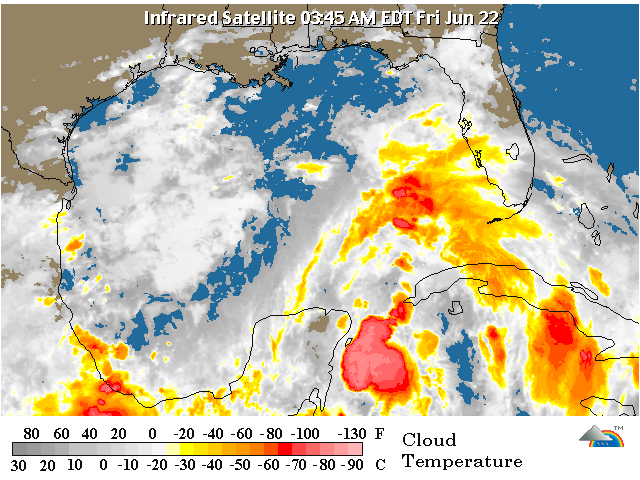
twitter:breakingweather twitterde op donderdag 21-06-2012 om 13:46:27 RT @henry_margusity: We should have a storm in the Gulf of Mexico by the end of the weekend or early next week. reageer retweet
 RT @
RT @
Geloof er niets van. Deze depressie is er "al" een tijdje en er gebeurt niets mee en zal ook weer verdwijnen.quote:twitter:breakingweather twitterde op donderdag 21-06-2012 om 13:46:27 RT @henry_margusity: We should have a storm in the Gulf of Mexico by the end of the weekend or early next week. reageer retweet
quote:1. A BROAD AREA OF LOW PRESSURE OVER THE SOUTH-CENTRAL GULF OF MEXICO
IS PRODUCING A LARGE AREA OF CLOUDINESS... SHOWERS...AND
THUNDERSTORMS THAT EXTENDS FROM THE NORTHWESTERN CARIBBEAN SEA
NORTHWARD INTO THE SOUTHEASTERN GULF OF MEXICO AND FLORIDA.
STRONG UPPER-LEVEL WINDS OVER THE GULF OF MEXICO ARE EXPECTED TO
DIMINISH IN A DAY OR SO...AND SOME GRADUAL DEVELOPMENT OF THIS
SYSTEM IS POSSIBLE AS THE DISTURBANCE MOVES SLOWLY NORTHWARD TOWARD
THE CENTRAL GULF OF MEXICO. THIS SYSTEM HAS A MEDIUM CHANCE...30
PERCENT...OF BECOMING A TROPICAL CYCLONE DURING THE NEXT 48 HOURS.
REGARDLESS OF DEVELOPMENT...HEAVY RAINS AND LOCALIZED FLOODING ARE
POSSIBLE ACROSS THE YUCATAN PENINSULA...WESTERN CUBA...AND SOUTHERN
FLORIDA THROUGH SATURDAY.