WKN Weer, Klimaat en Natuurrampen
Lees alles over het onstuimige weer op onze planeet, volg orkanen en tornado's, zie hoe vulkanen uitbarsten en hoe Moeder Aarde beeft bij een aardbeving. Alles over de verwoestende kracht van onze planeet en tal van andere natuurverschijnselen.


GFS laat hem meer richting land trekken inderdaad.quote:Op vrijdag 27 januari 2012 14:16 schreef Frutsel het volgende:
'Iggy' lijkt ietwat meer langs de kust te trekken dan gisteren of vergis ik mij?


quote:IGGY leaves 16 dead in Indonesia
At least 16 people were confirmed killed and more than 2,300 houses damaged in torrential rains and strong winds that lashed much of Indonesia over the past few days.
Sutopo Purwo Nugroho, a spokesman for the National Disaster Mitigation Agency (BNPB), said on Sunday that most of those killed were struck by trees felled by severe winds.
“Fourteen people were crushed by falling trees,” the spokesman said. “In total, 60 people were injured.”
He added that more than 2,300 houses in 35 districts and cities across Java and Bali had been damaged in the last four days due to heavy winds and rain whipped up by Tropical Cyclone Iggy, churning just south of Bali and the Nusa Tenggara island chain.
“But now Tropical Cyclone Iggy has weakened and is moving away from Indonesia,” he said.
Elsewhere in the country, at least two other people were confirmed killed as a result of the foul weather.
In Bali, the heavy rains caused a massive landslide on Saturday in the Taman Ayun Temple area, a popular tourist spot, killing an 18-month-old baby.
Ketut Parwa, the head of the Bali Search and Rescue Agency, said the child had been asleep with her mother at a food stall in the temple’s parking lot when the disaster struck at 11 p.m. They had gone to the food stall to take shelter from the rain.
Parwa said the 12-meter-high precipice on which the food stall was located suddenly gave way, burying the child in tons of mud. The mother managed to escape. Rescuers recovered the child’s body on Sunday evening.
In Lebak district, Banten, authorities recovered the body of a boy who had been swept away and drowned in a river. They are continuing their search for a friend who was with him.
Irna, an official with the local search team, said the victims, both 14-year-old students at an Islamic boarding school, went missing on Friday while swimming in the rain-swollen Ciberang River. One of the bodies was recovered later that day and given to the family for burial.
“We’ve combed a four-kilometer stretch of the river over the past two days, but we still haven’t been able to find the second boy,” Irna said.
“We’re having great difficulty in our search because of the strong current in the river.”
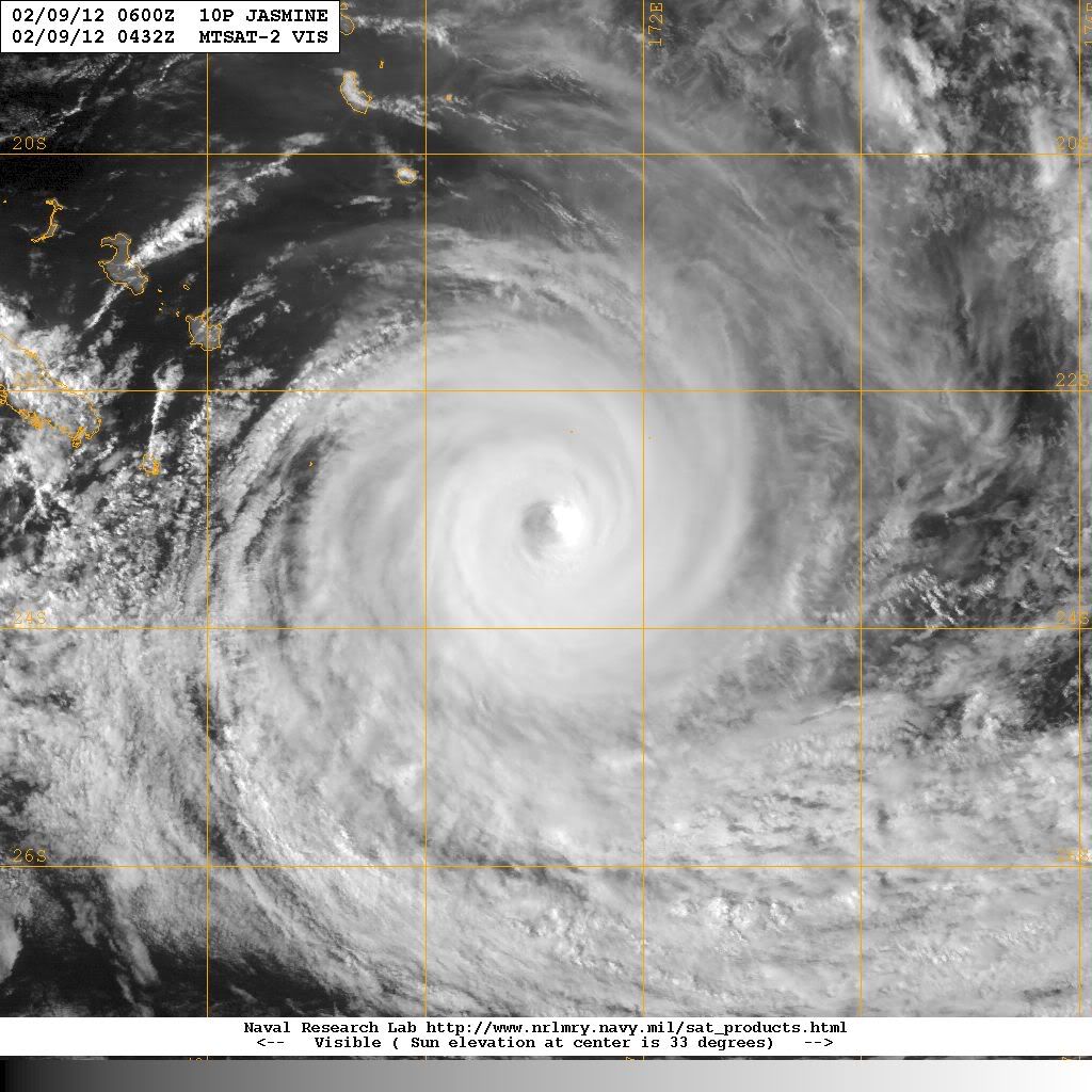
Nasa's hurricane pagequote:SO INDIAN OCEAN - We're watching another low near Madagascar, now that Funso fizzled. This low is near 16.8S 44.2E, 210 nm northwest of ANTANANARIVO, MADAGASCAR. The low-level center is partially exposed, and its grazing the coast of Cape Saint Andre Region and is moving back into the warm Mozambique Channel. It has a medium chance for becoming a tropical depression.
Maar goed dat die cycloon van de kust wegtrekt...
Evacuaties vanwege overstromingen in noordoosten van Australië
Ze kunnen geen 2e Yasi gebruiken daar nu
Evacuaties vanwege overstromingen in noordoosten van Australië
Ze kunnen geen 2e Yasi gebruiken daar nu


Dat zou wat zijn zeg... subtropische storm in februari daarroquote:Tropics Trying to Come Alive in the Gulf of Mexico
The calendar says it's early February, but that is not stopping the tropics from trying to come alive in the south-central Gulf of Mexico.
The area of concern is a cluster of showers and thunderstorms spinning in the southern Gulf of Mexico, near the Yucatan Peninsula.
This broad area of low pressure has not only put the AccuWeather.com Hurricane Center on alert, but prompted the National Hurricane Center in Miami, Fla., to state, "this area is being closely monitored for possible further development."
Tropical season in the Atlantic Basin is not confined to the months spanning June to November, but rather when the conditions are conducive.
Some of those key ingredients needed for the development of at least a subtropical depression (a system with partial tropical characteristics) are currently trying to come together in the south-central Gulf of Mexico.
Water temperatures in the south-central Gulf of Mexico are near 80 degrees, the threshold for tropical development.
While not absent, the wind shear (disruptive winds high in the atmosphere) present is not strong enough to totally inhibit development.
If a subtropical depression or storm were to take shape (acquiring the name "Alberto" from the 2012 list), the AccuWeather.com Hurricane Center feels it would track into South Florida later Monday into Monday night.
Torrential rain causing flooding in low-lying and poor-drainage areas would be the main concern, even if development fails to take place.
Evident by the radar from Key West, Fla., downpours will continue to get pushed into South Florida well ahead of the actual low's center.
The formation of a tropical storm in February is rare, but has occurred once before in history. The Groundhog Day Tropical Storm from 1952 developed in the northwestern Caribbean before tracking across South Florida.


Zal wel een puinhoop worden in Madagascar.quote:
Aloa bedankt
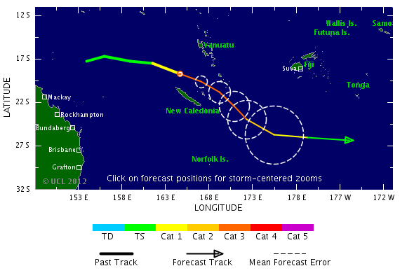
Cat 4 orkaan nadert Madagascar
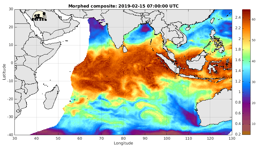
Die andere krul bij Indonesie is deze invest. Of het wat gaat worden is afwachten.


Het zou trouwens zeer zeldzaam zijn als een orkaan vanaf de 90e breedtegraad helemaal weet te overleven tot aan Madagascar.
Ze kunnen het soms lang volhouden. Maar de meeste zakken dan weer richting het zuiden en verdwijnen.quote:
Het zou trouwens zeer zeldzaam zijn als een orkaan vanaf de 90e breedtegraad helemaal weet te overleven tot aan Madagascar.
Tropische storm voor Madagascar
Na Giovanna, waarbij meer dan 30 mensen zijn omgekomen en 250.000 mensen dakloos zijn geworden, staat Madagascar weer een nieuwe storm te wachten. Het systeem ligt nu aan de oostkant van het eiland en zal over de noordkant van het eiland trekken, waarna het zich verder lijkt te ontwikkelen in het kanaal van Mozambique. Madagascar en Mozambique krijgen hierdoor te maken met zeer veel neerslag wat overstromingen e.d. kan veroorzaken.
Volgens GFS ligt het systeem op dinsdag tussen Madagascar en Mozambique en zal daar, net als Giovanna enkele dagen rond blijven tollen. Op onderstaande kaartje is nog een ander systeem te zien ten oosten van Madagascar, maar het lijkt erop dat deze niet voor veel problemen gaat zorgen. Deze gaat wel een hogere categorie worden.
Na Giovanna, waarbij meer dan 30 mensen zijn omgekomen en 250.000 mensen dakloos zijn geworden, staat Madagascar weer een nieuwe storm te wachten. Het systeem ligt nu aan de oostkant van het eiland en zal over de noordkant van het eiland trekken, waarna het zich verder lijkt te ontwikkelen in het kanaal van Mozambique. Madagascar en Mozambique krijgen hierdoor te maken met zeer veel neerslag wat overstromingen e.d. kan veroorzaken.

Volgens GFS ligt het systeem op dinsdag tussen Madagascar en Mozambique en zal daar, net als Giovanna enkele dagen rond blijven tollen. Op onderstaande kaartje is nog een ander systeem te zien ten oosten van Madagascar, maar het lijkt erop dat deze niet voor veel problemen gaat zorgen. Deze gaat wel een hogere categorie worden.