WKN Weer, Klimaat en Natuurrampen
Lees alles over het onstuimige weer op onze planeet, volg orkanen en tornado's, zie hoe vulkanen uitbarsten en hoe Moeder Aarde beeft bij een aardbeving. Alles over de verwoestende kracht van onze planeet en tal van andere natuurverschijnselen.


De sensor is het al enige tijd aan het begeven. vandaar dat er afentoe stukjes missen
1117893 21/12/2011 02:46:19 27.6497 -18.0390 18 2.0 4 SW EL PINAR.IHI
[ Bericht 20% gewijzigd door bwt op 21-12-2011 12:07:04 ]


1117893 21/12/2011 02:46:19 27.6497 -18.0390 18 2.0 4 SW EL PINAR.IHI
quote:Update 20/12 23:55 UTC
- Harmonic tremor is growing again since the last couple of hours
- At 18:26 UTC a weak M 0.9 earthquake happened at a depth of 11 km below the El Golfo beach area
Update 20/12 23:43 UTC
- Joke has a talk with Maria José Blanco from IGN during the morning hours. Here is synopsis of the answers Joke got on her many questions :
- the current emissions are mainly gas emissions
- gas is part of the erupting magma and while magma is flowing down along the volcano slope, the gas finds his way to the surface
- sometimes the emission of gas is mixed with ashes, but we havent seen or analyzed the ash in the current new vents. We hope to get some samples today as the Salvamar Adhara is out to collect material. At the time of writing this update, no additional details are known.
- escaping gas can also trigger the tremors
- the main emitted gas component is CO². We are anxious to see what will happen with the Involcan CO² statistics as we see a lot of gas coming out of the vents. Since the end of November the measured CO² values are almost constantly decreasing.
- i can also tell you that a new bathymetry mission of the Sarmiento da Gamboa is on its way and will start on Thursday. The Sarmiento will probably only work at night. Joke jokes that we will certainly tell this to our readers as we want to avoid another hoax lava eruption : ) . (ER : we also remind our readers that the harmonic tremor graph will probably show drumbeats caused by the instruments of the Sarmiento).
Oftewel: de tremors zijn een stuk zwakker waardoor de kleine bevingen nu ook gedetecteerd kunnen worden.quote:As a weak sismito in Frontera afternoon, just below CTAN almost certainly now the IGN maps showing where all the seismic stations on the island, every detail of quality. As the tremor is down, can see and recognize in the smaller earthquakes simogramas since they are not shielded. (Enrique).
1117890 20/12/2011 18:26:14 27.7645 -18.0580 11 0.9 4 W FRONTERA.IHI
[bron]
quote:NOTE AVCAN 394 - EARTHQUAKE ACTIVITY-VOLCANIC - HIERRO ISLAND - DECEMBER 21 2011-10:30 h peninsular - seismic-volcanic activity continues to moderate-low, with seismicity located in the Gulf, the Julan and mar de las Calmas. Continue an important sign of volcanic tremor in the Restinga area, with an amplitude that has been fluctuating since the last part, with some smaller explosions than other days, possibly hydromagmatic. No new earthquakes located. Days ago 1. Yesterday 1. Today van 2. A total of 11,939 earthquakes are located in El Hierro by IGN from 9:00 am of July 19, 2011.

[ Bericht 20% gewijzigd door bwt op 21-12-2011 12:07:04 ]
<a href="http://goo.gl/q8fhTe" target="_blank">FAQ?</a>
<a href="http://goo.gl/gYvZFq" target="_blank">Geel is een zonnige en vrolijke kleur, als hij tenminste enigszins warm is gekleurd en wat naar het oranje neigt</a>
<a href="http://goo.gl/gYvZFq" target="_blank">Geel is een zonnige en vrolijke kleur, als hij tenminste enigszins warm is gekleurd en wat naar het oranje neigt</a>
quote:Update 21/12 – 11:13 UTC
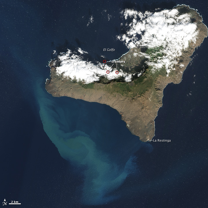
- 4 out of the last 6 earthquakes we have noticed the last couple of days are occurring at “unusual” depths. Also the 2 earthquakes from earlier today happened at 17.9 km (below land) and 13.1 km (Las Calmas sea) (for details zie hierboven). Just like AVCAN, we also think that these 2 earthquakes occurred in the vicinity of the feeder lava tubes who are connecting the El Golfo area with the Las Calmas sea vent. We are very curious to look at todays satellite picture (will take a few more hours) to find out if other vents have opened, as we cannot see any activity on the webcams.
- The GPS deformation graph which we can see on the IGN website shows NO significant increase but NO significant decrease neither.
quote:Update 21/12 13:52 UTC
As promised before, our attention this afternoon was also going to the NASA Modis satellite picture. We have mounted 3 pictures under each other, each one showing the stain in another way.
Picture 1 is the visual picture as extracted from the Modis satellite picture of today (lucky that El Hierro was cloud free today)
Picture 2 is the same picture color enhanced but also with the current vent patch (which we made white)
Picture 3 is the same picture color reduced
If you click on the picture a full size version of the extract can be seen.
The NASA modis picture is courtesy NASA Earth Data
plaatje 2 en 3 op earthquacke report te vinden

[ Bericht 37% gewijzigd door bwt op 21-12-2011 15:19:11 ]
<a href="http://goo.gl/q8fhTe" target="_blank">FAQ?</a>
<a href="http://goo.gl/gYvZFq" target="_blank">Geel is een zonnige en vrolijke kleur, als hij tenminste enigszins warm is gekleurd en wat naar het oranje neigt</a>
<a href="http://goo.gl/gYvZFq" target="_blank">Geel is een zonnige en vrolijke kleur, als hij tenminste enigszins warm is gekleurd en wat naar het oranje neigt</a>

Je moet me even helpen in deze, wat is VICINITY?
Ik kan toch aardig Engels, maar soms weet ik het niet.......
Ik kan toch aardig Engels, maar soms weet ik het niet.......
in de nabijheid vanquote:Op woensdag 21 december 2011 19:14 schreef 1boefje het volgende:
Je moet me even helpen in deze, wat is VICINITY?
Ik kan toch aardig Engels, maar soms weet ik het niet.......
quote:Eruptive PROCESS EL HIERRO STILL ACTIVE SIGN AS SHOWN IN THE TREMOR OF THE LAST DAYS.
12/21/2011 ... 18:23 - Ministry of Economy, Finance and Security
IGN has confirmed the location of two earthquakes since Sunday December 18
The National Geographic Institute (IGN) has confirmed the direction of the Civil Protection Plan for Volcanic Risk (PEVOLCA) that shows the signal as the tremor associated with the eruption, the eruptive process in El Hierro is still active. Based on these data, last Sunday, December 18, the signal decreased slightly presenting tremor few intermittent pulses, while on Monday increased very slightly since the beginning of the day until 8:00 am when he held constant, present virtually pulses. On Tuesday, the tremor signal decreased slightly since the beginning of the day until 10:00 hours remaining stable until the night that showed a slight increase.
As for earthquakes during the last three days two movements have been found, none of them felt by the population. The first occurred on Monday, December 19th at 4:09 pm with a magnitude of 2.0 on the Richter scale and 19 kilometers deep. The second, recorded on Tuesday, at 18:26 hours, reached a magnitude of 0.9 and was located at a depth of 11 kilometers.
Deformations
Control stations of the deformation maintain the same pattern of recent days, following in general the same trend of stability in the horizontal components. For its part, the pattern in the vertical components is deflation at the stations south of the island and stability in the rest.
On the spot, during the day on Sunday, it was not easily distinguishable due to the intense surge since the issue seemed weaker. The head could be seen, although less clearly than in previous days, surrounded by a blue-green area.
On Monday, the head of the stain was clearly visible in the morning as a lighter area that was driven by surface currents, while on Tuesday, due to strong winds and the sea state, the head could not be visualized appreciating slightly more surface area affected by the eruption.

1118048 22/12/2011 09:11:07 27.6898 -18.0816 26 2.8 4 W EL PINAR.IHI

Hey, het valt me op dat de tremor afneemt en dat er om 9:11 een stevige beving is geweest van 2.8 (kan nog gecorrieerd worden)

Lichte streep is overduidelijk - maar geen spike in de blauwe balk er boven.
[ Bericht 5% gewijzigd door bwt op 22-12-2011 11:12:16 ]
<a href="http://goo.gl/q8fhTe" target="_blank">FAQ?</a>
<a href="http://goo.gl/gYvZFq" target="_blank">Geel is een zonnige en vrolijke kleur, als hij tenminste enigszins warm is gekleurd en wat naar het oranje neigt</a>
<a href="http://goo.gl/gYvZFq" target="_blank">Geel is een zonnige en vrolijke kleur, als hij tenminste enigszins warm is gekleurd en wat naar het oranje neigt</a>
Dus de regelmatige bevingen worden wat minder en rustiger, maar opeens zijn er af en toe uitschieters. Houdt dit weer in dat er magma naar boven komt?
Wat zegt dit?
Wat zegt dit?
quote:NOTE AVCAN 395 - EARTHQUAKE ACTIVITY-VOLCANIC - HIERRO ISLAND - DECEMBER 22 2011-13:00 h peninsular - seismic-volcanic activity continues to moderate-high, with seismicity located in the Gulf, the Julan and the Sea of las calmas. Continue an important sign of volcanic tremor in the Restinga area, with an amplitude that is increasing with slight fluctuations since the last part with a few more explosions than other days, possibly hydromagmatic. The magnitude between 2.8 and 2.2. New earthquakes 2. 22 and 26km depth. Days ago 1. Yesterday 3. Today they 1. A total of 11,941 earthquakes are located in El Hierro by IGN from 9:00 am of July 19, 2011.
Na een weekje rust zijn er nu juist weer meer bevingen met 2.2 (niet voelbaar) en 2.8 (voelbaar)quote:
Dus de regelmatige bevingen worden wat minder en rustiger, maar opeens zijn er af en toe uitschieters. Houdt dit weer in dat er magma naar boven komt?
Wat zegt dit?
De tremors zijn juist weer erg grillig - sterker of zwakker wisselt elkaar af.
<a href="http://goo.gl/q8fhTe" target="_blank">FAQ?</a>
<a href="http://goo.gl/gYvZFq" target="_blank">Geel is een zonnige en vrolijke kleur, als hij tenminste enigszins warm is gekleurd en wat naar het oranje neigt</a>
<a href="http://goo.gl/gYvZFq" target="_blank">Geel is een zonnige en vrolijke kleur, als hij tenminste enigszins warm is gekleurd en wat naar het oranje neigt</a>
Op 15-12 zakte de tremors erg snel in en kwam erg langzaam weer terug.quote:
Maar wat betekend deze verandering dan?
Of weet niemand dat?

Het leek daardoor dat de vulkaan zijn laatste adem aan het uitblazen was. Ook omdat de aardbevingen vrijwewl geheel weg vielen.
Maar de tremors pakten langzaam weer wat op en het bleef regelmatig schommelen.
En nu komen er langzzaam aan ook weer meer en zwaardere aardbevingen.
Je zou dan ook verwachten dat de activiteit weer toeneemt.
Maar zoals altijd met vulkanen - ze zijn onvoorspelbaar.
<a href="http://goo.gl/q8fhTe" target="_blank">FAQ?</a>
<a href="http://goo.gl/gYvZFq" target="_blank">Geel is een zonnige en vrolijke kleur, als hij tenminste enigszins warm is gekleurd en wat naar het oranje neigt</a>
<a href="http://goo.gl/gYvZFq" target="_blank">Geel is een zonnige en vrolijke kleur, als hij tenminste enigszins warm is gekleurd en wat naar het oranje neigt</a>
goede eilanden, slechte eilanden? 
Inorbit: zeg dat dan typluie triangeljosti
Beauregard: Een beetje FOK!ker laat het brood door z'n moeder smeren.
Ecosia
ek's 'n flash drive, jy's 'n floppy
Beauregard: Een beetje FOK!ker laat het brood door z'n moeder smeren.
Ecosia
ek's 'n flash drive, jy's 'n floppy
quote:Op donderdag 22 december 2011 16:37 schreef Jumparound het volgende:
goede eilanden, slechte eilanden?
Weer een mooie foto van vandaag
En de tremors van vandaag nemen vanaf 15.00 (locale tijd) weer toe lijkt het.

En de tremors van vandaag nemen vanaf 15.00 (locale tijd) weer toe lijkt het.
<a href="http://goo.gl/q8fhTe" target="_blank">FAQ?</a>
<a href="http://goo.gl/gYvZFq" target="_blank">Geel is een zonnige en vrolijke kleur, als hij tenminste enigszins warm is gekleurd en wat naar het oranje neigt</a>
<a href="http://goo.gl/gYvZFq" target="_blank">Geel is een zonnige en vrolijke kleur, als hij tenminste enigszins warm is gekleurd en wat naar het oranje neigt</a>
De stevige tremor schommelingen zetten door.
Ook 2 bevingen geregistreerd van 1.6
1118245 23/12/2011 04:09:20 27.6770 -18.0363 15 1.6 mbLg SW EL PINAR.IHI [+]
1118240 23/12/2011 02:16:39 27.8948 -18.0807 16 1.6 mbLg NW FRONTERA.IHI [+]
[ Bericht 24% gewijzigd door bwt op 23-12-2011 16:00:42 ]

Ook 2 bevingen geregistreerd van 1.6
1118245 23/12/2011 04:09:20 27.6770 -18.0363 15 1.6 mbLg SW EL PINAR.IHI [+]
1118240 23/12/2011 02:16:39 27.8948 -18.0807 16 1.6 mbLg NW FRONTERA.IHI [+]
quote:NOTE AVCAN 396 - EARTHQUAKE ACTIVITY-VOLCANIC - HIERRO ISLAND - DECEMBER 23 2011-11:30 h peninsular - seismic-volcanic activity continues to moderate, localized seismicity in the Gulf and the coastal area of Julan to Tacorón Creek. Continue an important sign of volcanic tremor in the Restinga area, with an amplitude that is increasing with slight variations in maximum and minimum intensity approx every 6 hours since the last part with a few more explosions than other days, possibly hydromagmatic. The magnitude of 1.6. New earthquakes 2. 15 and 16km depth. Before yesterday 3. Yesterday 1. Today van 2. A total of 11,943 earthquakes are located in El Hierro by IGN from 9:00 am of July 19, 2011.
quote:More about volcanic seismology from the OVSICORI:
"The seismic signals originating from volcanic areas, are unique to each volcano and will depend on the activity that counts and that is why many researchers have studied different seismic signals can be recorded in a volcano. Some of them and Minakami, Latter, Chouet, McNut, Koyanagi, White and others have contributed according to their experiences in different active volcanoes and with the advancement in technology in the classification of volcanic earthquakes. "(John Vincent)
quote:Update 23/12 14:00 UTC
Todays NASA Modis satellite image (from max. a couple of hours ago) shows a very strange picture from the stain and the emission vent. The left white patch is the main vent emission point and small stain. The right white patch at the smallest point of the stain maybe a small remaining cloud patch from the bigger cloud range below it.
en de originele versie


[ Bericht 24% gewijzigd door bwt op 23-12-2011 16:00:42 ]
<a href="http://goo.gl/q8fhTe" target="_blank">FAQ?</a>
<a href="http://goo.gl/gYvZFq" target="_blank">Geel is een zonnige en vrolijke kleur, als hij tenminste enigszins warm is gekleurd en wat naar het oranje neigt</a>
<a href="http://goo.gl/gYvZFq" target="_blank">Geel is een zonnige en vrolijke kleur, als hij tenminste enigszins warm is gekleurd en wat naar het oranje neigt</a>
Vandaag - van piek tot piek met de tremors:een uur of 5.00 tot een uur of 20.00.
Het is allemaal afwachten.
foto earthquacke report
Prettige feestadgen allemaal.
[ Bericht 30% gewijzigd door bwt op 24-12-2011 23:52:53 ]

Eigenlijk gebeurt er momenteel geen bal.quote:NOTE AVCAN 397 - EARTHQUAKE ACTIVITY-VOLCANIC - HIERRO ISLAND - DECEMBER 24 2011-10:00 h peninsular - seismic-volcanic activity continues to moderate-low, without seismicity localized, but with some weaknesses detected event (23:06 h yesterday, 00: 13, 05.20, and 6:23 h). Continue an important sign of volcanic tremor in the Restinga area, with an amplitude that is increasing (15%) since the last part, with some explosions, possibly hydromagmatic. No new earthquakes located. Days ago 1. Yesterday 2. Now go 0. A total of 11,943 earthquakes are located in El Hierro by IGN from 9:00 am of July 19, 2011.
Today shows the deformation, especially the HI04 that maintains tendency to deform (Withdraws from la Frontera) and HI03 does not move. FRON also seems that maintains the trend on TN03 and MAZO IZAN (walks).
Het is allemaal afwachten.
foto earthquacke report
Prettige feestadgen allemaal.
[ Bericht 30% gewijzigd door bwt op 24-12-2011 23:52:53 ]
<a href="http://goo.gl/q8fhTe" target="_blank">FAQ?</a>
<a href="http://goo.gl/gYvZFq" target="_blank">Geel is een zonnige en vrolijke kleur, als hij tenminste enigszins warm is gekleurd en wat naar het oranje neigt</a>
<a href="http://goo.gl/gYvZFq" target="_blank">Geel is een zonnige en vrolijke kleur, als hij tenminste enigszins warm is gekleurd en wat naar het oranje neigt</a>

De top vande vulkaan lijkt 15-20 meter ingestort te zijn, maar dat schijnt normaal te zijn voor vulkanen die aan het groeien zijn. Het zachtere materiaal zakt in elkaar door de druk van hogere lagen.
En nog een 1.6 beving boven Fronteraquote:Important Update 25/12 – 09:23 UTC
- IGN reported a new M 1.6 earthquake at a depth of 21 km at 01:14. Epicenter in the El Golfo bay
CISC (Unidad de Tecnología Marina del Consejo Superior de Investigaciones Científicas) has reported yesterday that the top of the main vent has collapsed 15 to 20 meter. The new depth was obtained during a bathymetry mission by the research vessel Sarmiento de Gamboa. The acoustic image was made last Thursday and Friday (when we saw the Sarmiento de Gamboa going up and down on the stain) .The white line on the image is the sea floor. The orange tones are reflecting the erupted magma. The suspended material that we can see in the stain and on the emission vents is colored brown (ER: hard to see but on top). The orange colored magma is flowing down along the slopes of the cone.
Last time, the depth of the cone was measured as 140 to 150 meter by the Ramon Margalef. Taking into account the new acoustic study, we can conclude that the depth is now in between 155 and 170 meter, still far away from a Surtseyan eruption.
1118557 25/12/2011 01:14:41 27.7884 -18.0525 21 1.6 4 NW FRONTERA.IHI

De tremors vvan vandaag zijn wel erg gelijkmatig (en saai?)

quote:NOTE AVCAN 398 - EARTHQUAKE ACTIVITY-VOLCANIC - HIERRO ISLAND - DECEMBER 26 25 2011-10:00 h peninsular - seismic-volcanic activity continues to moderate, without seismicity located with seismicity located in the Gulf and some weak events detected. Continued volcanic tremor signal important in Restinga area, with an amplitude that is increasing (5%) since the last part, after midnight on something and then has vueto up with some explosions, possibly hydromagmatic. The magnitude between 1.6 and 0.9. New earthquakes 2. 15 and 21km depth .. Before yesterday 2. Yesterday 1. Today they 1. A total of 11,945 earthquakes are located in El Hierro by IGN from 9:00 am of July 19, 2011.
[ Bericht 3% gewijzigd door bwt op 26-12-2011 09:59:41 ]
<a href="http://goo.gl/q8fhTe" target="_blank">FAQ?</a>
<a href="http://goo.gl/gYvZFq" target="_blank">Geel is een zonnige en vrolijke kleur, als hij tenminste enigszins warm is gekleurd en wat naar het oranje neigt</a>
<a href="http://goo.gl/gYvZFq" target="_blank">Geel is een zonnige en vrolijke kleur, als hij tenminste enigszins warm is gekleurd en wat naar het oranje neigt</a>
Ik geloof dat de meet apparatuur op el Hierro kapot is.
Er is geen signaal meer. - Zal wel na kerst gefixt worden....
[ Bericht 25% gewijzigd door bwt op 26-12-2011 12:57:56 ]
Er is geen signaal meer. - Zal wel na kerst gefixt worden....

quote:SURFACE AREA IN THE cone of el Hierro volcan has decreased from 15 to 20 M.
24/12/2011 ... 15:47 - Ministry of Economy, Finance and Security
This is a normal process in the formation of volcanic cones that balance adjustments volcanic structure
The Sarmiento de Gamboa oceanographic ship a new acoustic image capture in the area of the eruption
The Marine Technology Unit of the CSIC has informed the direction of the Civil Protection Plan for Volcanic Risk (PEVOLCA) that according to barimétrico recognition by the Sarmiento de Gamboa research vessel the most superficial of the volcanic cone on the island of El Hierro has experienced a small decrease of about 15 to 20 meters. This process, they say, is common in the formation of volcanic cones that undergo rapid growth and a series of adjustments that rebalance the volcanic structure.
In addition, the Marine Technology Unit of the CSIC has provided the direction of an acoustic image PEVOLCA obtained yesterday with one of the Sarmiento de Gamboa fishfinders showing what was happening at the time of image capture in the area the eruption.
In the image, comparable with ultrasound, the white profile corresponds to the relief and topography in the area of the volcano, while orange tones reflect the material being ejected from the volcano.
Also, in the time when the measurement was made, the emission from the volcano reached the surface. Some of the materials were suspended in the superficial zone correspond to the color brown stain is observed on the surface. For its part, the material of orange, it falls from the surface on the flanks of the volcano and the whole area of the eruption.
Tremor and seismicity
On the other hand, the National Geographic Institute (IGN) has confirmed to the direction of PEVOLCA in the day yesterday tremor signal remained at the same values of the previous days although presenting greater variability of long period during the day, no pulses.
As for earthquakes, it is noteworthy that in the day yesterday there were two earthquakes with a magnitude of 1.6 degrees, none of them felt by the population. The first, at 2:16 hours was found in the area of the Gulf and 16 kilometers deep, while the second was recorded at 4:09 hours southwest of El Pinar at a depth of 15 kilometers.
In total, from July 19 11 934 events were located on the island of El Hierro.
Deformations
The control stations maintained a stable pattern deformation in the horizontal COMPONENTS and a tendency towards stability in the vertical throughout the island
With respect to the spot, on the morning of yesterday appreciated the greenish stain extending to the south and no header. During the afternoon there was bubbling in the downtown area and stain issuer extending around to the southeast.
In addition, the report of the flight mission conducted in 103 SASEMAR yesterday afternoon, indicated the detection of a circular well-defined focus in the broadcast area without observing material or surface water vapor. The IR sensor detected an anomaly of 2.2 ° C in the emission from the sea in the background.
Acoustic image of the eruptive process =>
PDF van gister geplaatst plaatje
quote:NOTE AVCAN 399 - EARTHQUAKE ACTIVITY-VOLCANIC - HIERRO ISLAND - DECEMBER 26 2011-11:00 h peninsular - seismic-volcanic activity continues to moderate-low, with weak seismicity located in the Gulf and some weak events detected. Continued volcanic tremor signal important in Restinga area, with an amplitude similar since the last part (no signal since yesterday after 22:00 h, just looks a bit from 7:00 to 9:00 h) with some explosions, possibly hydromagmatic. The magnitude of only 0.6 earthquake. New earthquakes 1. 12km depth. Before yesterday 2. Yesterday 1. Today they 1. A total of 11,947 earthquakes are located in El Hierro by IGN from 9:00 am of July 19, 2011.
[ Bericht 25% gewijzigd door bwt op 26-12-2011 12:57:56 ]
<a href="http://goo.gl/q8fhTe" target="_blank">FAQ?</a>
<a href="http://goo.gl/gYvZFq" target="_blank">Geel is een zonnige en vrolijke kleur, als hij tenminste enigszins warm is gekleurd en wat naar het oranje neigt</a>
<a href="http://goo.gl/gYvZFq" target="_blank">Geel is een zonnige en vrolijke kleur, als hij tenminste enigszins warm is gekleurd en wat naar het oranje neigt</a>

Tremors nemen weer toe.
Nieuwe NASA foto. met verhaal
quote:NOTE 400 AVCAN - EARTHQUAKE ACTIVITY-VOLCANIC - HIERRO ISLAND - DECEMBER 27 2011-10:30 h peninsular - seismic-volcanic activity continues to moderate-low, without seismicity localized, but with some weaknesses detected event (1:13 and 3:28 a.m.) . Continue an important sign of volcanic tremor in the Restinga area, with an amplitude that is on the rise since yesterday at 19:00 h (40%) since the last part, with some explosions, possibly hydromagmatic, especially increasing from midnight. No new earthquakes located. Days ago 1. Yesterday 1. Now go 0. A total of 11,947 earthquakes are located in El Hierro by IGN from 9:00 am of July 19, 2011.
In the spectrogram can clearly see the earthquake of 3:28 pm

[ Bericht 5% gewijzigd door bwt op 27-12-2011 12:23:14 ]
<a href="http://goo.gl/q8fhTe" target="_blank">FAQ?</a>
<a href="http://goo.gl/gYvZFq" target="_blank">Geel is een zonnige en vrolijke kleur, als hij tenminste enigszins warm is gekleurd en wat naar het oranje neigt</a>
<a href="http://goo.gl/gYvZFq" target="_blank">Geel is een zonnige en vrolijke kleur, als hij tenminste enigszins warm is gekleurd en wat naar het oranje neigt</a>
quote:


[ Bericht 1% gewijzigd door bwt op 27-12-2011 19:37:09 ]
<a href="http://goo.gl/q8fhTe" target="_blank">FAQ?</a>
<a href="http://goo.gl/gYvZFq" target="_blank">Geel is een zonnige en vrolijke kleur, als hij tenminste enigszins warm is gekleurd en wat naar het oranje neigt</a>
<a href="http://goo.gl/gYvZFq" target="_blank">Geel is een zonnige en vrolijke kleur, als hij tenminste enigszins warm is gekleurd en wat naar het oranje neigt</a>
en een veel zwakkere bevingquote:Earthquake of 6.5 in the middle of the Siberian plate in a place where normal is not very powerful so this seismicity. It shows a teleseismic at all stations on line of the Canary Islands, except the CHIE that shielded by the tremor signal, which continues to rise, now is three times stronger in amplitude than yesterday when it began to climb 19:00 pm o'clock
M 6.5 - SOUTHWESTERN SIBERIA, RUSSIA - 27/12/2011 15:21 UTC
[bron]
1119077 27/12/2011 21:22:13 27.7850 -18.0459 21 1.8 4 NW FRONTERA.IHI

<a href="http://goo.gl/q8fhTe" target="_blank">FAQ?</a>
<a href="http://goo.gl/gYvZFq" target="_blank">Geel is een zonnige en vrolijke kleur, als hij tenminste enigszins warm is gekleurd en wat naar het oranje neigt</a>
<a href="http://goo.gl/gYvZFq" target="_blank">Geel is een zonnige en vrolijke kleur, als hij tenminste enigszins warm is gekleurd en wat naar het oranje neigt</a>
jeeej! We gaan weer verder 
Inorbit: zeg dat dan typluie triangeljosti
Beauregard: Een beetje FOK!ker laat het brood door z'n moeder smeren.
Ecosia
ek's 'n flash drive, jy's 'n floppy
Beauregard: Een beetje FOK!ker laat het brood door z'n moeder smeren.
Ecosia
ek's 'n flash drive, jy's 'n floppy
Echt geen idee wat die vulkaan van plan is
Vreemde pieken zitten er in.
AVCAN heeft het ook over drumbeats.

quote:Update 28/12 – 08:05 UTC
- 1 hour later it looks like we had a vent collapse as the tremor is getting gradually back again
Update 28/12 – 07:05 UTC
- After some really turbulent harmonic tremor in between 05:00 and 06:00, harmonic tremor came almost to a halt. We do think that the eruption subsided a lot the last several days but that the current decrease has to be linked to a vent collapse. If this is the case the harmonic tremor will gradually pick up gain as the magma finds his way out.


quote:NOTE AVCAN 401 - EARTHQUAKE ACTIVITY-VOLCANIC - HIERRO ISLAND - DECEMBER 28 2011-10:30 h peninsular - seismic-volcanic activity continues to moderate, localized seismicity in el Golfo and Mar de las Calmas and some weak events detected. Continued volcanic tremor signal important in Restinga area, still strong until between 5:00 and 6:00 madrugaga has been made to hydromagmatic stronger explosions, 3 or 4, by interaction with water which have had to change the morphology of the outlet duct, or open another mouth, cleared completely, and making it flow smoothly, which has led to the fall of the tremor. After an hour with low tremor, has been again giving small cyclic explosions, the so-called Drumbeats .. these if they are .. with very short bursts at a mean time interval (such as half a minute or so). As for earthquakes, the magnitude was between 1.8 and 0.8. New earthquakes 3. Depth at 9, 12 and 21km. Days ago 1. Yesterday 2. Today they 1. A total of 11,950 earthquakes are located in El Hierro by IGN from 9:00 am of July 19, 2011.

Vreemde pieken zitten er in.
AVCAN heeft het ook over drumbeats.
<a href="http://goo.gl/q8fhTe" target="_blank">FAQ?</a>
<a href="http://goo.gl/gYvZFq" target="_blank">Geel is een zonnige en vrolijke kleur, als hij tenminste enigszins warm is gekleurd en wat naar het oranje neigt</a>
<a href="http://goo.gl/gYvZFq" target="_blank">Geel is een zonnige en vrolijke kleur, als hij tenminste enigszins warm is gekleurd en wat naar het oranje neigt</a>
ik denk, niet gehinderd door enige vorm van kennis, dat het nog wel een poosje gaat duren. De aanloop is zo lang geweest met zoveel opbouw (als je kijkt naar het aantal aardbevingen) dat het me stug lijkt dat het met een paar weken is afgelopen.
Ook wat hier boven staat over een vent collaps klinkt aannemelijk. Maar als er weer lichte ondiepe aardbevingen zijn lijkt het me dat er weer drukopbouw is...
maar ik ben een leek. Dus whatever ;-)
Ik blijf het nog wel even volgen
Ook wat hier boven staat over een vent collaps klinkt aannemelijk. Maar als er weer lichte ondiepe aardbevingen zijn lijkt het me dat er weer drukopbouw is...
maar ik ben een leek. Dus whatever ;-)
Ik blijf het nog wel even volgen
Inorbit: zeg dat dan typluie triangeljosti
Beauregard: Een beetje FOK!ker laat het brood door z'n moeder smeren.
Ecosia
ek's 'n flash drive, jy's 'n floppy
Beauregard: Een beetje FOK!ker laat het brood door z'n moeder smeren.
Ecosia
ek's 'n flash drive, jy's 'n floppy
Gister zijn de tremors zo goed als weg gevallen waardoor verschillende sites melden dat de vulcanische activiteit voorbij was.
Maar na 16:40 is er weer een kleine tremor die langzaam aan aan het groeien is.
[ Bericht 64% gewijzigd door bwt op 29-12-2011 08:27:07 ]
Maar na 16:40 is er weer een kleine tremor die langzaam aan aan het groeien is.

Oftewel - de vulkaan krijgt het steeds moeilijker om z'n lava uit te stoten omdat deze sneller afkoelt dan dat er nieuwe aangevoerd kan worden.quote:A personal opinion: I have the impression that the submarine volcano has released the final raspberry after a long deposition.
What I say of raspberry crackling under final.
And here's a theory that has upset the balance water-magma-pressure gases and it has penetrated the fissure running fast to cause evaporation and the resulting "bloat" as volcanic farts.
The result would be the crystallization of magma near the crack sealing and practice the same, preventing movements "peristaltic" of magma that no longer runs and therefore the tremor.
However, the digestion is not over ... would expect an increase in bowel sounds in the form of seismicity, and who knows ...
Turns out, the specific heat of water is 4 times greater than that of basaltic magma in mass, although the basalt is three times denser than water, the water still has greater cooling capacity comparing volumes. Therefore, it may have been broken as well preventing thermal equilibrium crystallization of basalt. But ... does not mean that the magma continues to have no end pressure ... simply does not flow as before because the water cools more quickly the volume of magma produced than before ...
That pressure, residual, could still have enough force to cause the opening of a crack after an event after shooting? Is it in the salty sea or land would be where the magma cools both the lack of water?
Counter-theory and opinions are welcome, the discussion comes the light.
(JR)
[bron]
[ Bericht 64% gewijzigd door bwt op 29-12-2011 08:27:07 ]
<a href="http://goo.gl/q8fhTe" target="_blank">FAQ?</a>
<a href="http://goo.gl/gYvZFq" target="_blank">Geel is een zonnige en vrolijke kleur, als hij tenminste enigszins warm is gekleurd en wat naar het oranje neigt</a>
<a href="http://goo.gl/gYvZFq" target="_blank">Geel is een zonnige en vrolijke kleur, als hij tenminste enigszins warm is gekleurd en wat naar het oranje neigt</a>