WKN Weer, Klimaat en Natuurrampen
Lees alles over het onstuimige weer op onze planeet, volg orkanen en tornado's, zie hoe vulkanen uitbarsten en hoe Moeder Aarde beeft bij een aardbeving. Alles over de verwoestende kracht van onze planeet en tal van andere natuurverschijnselen.


Lurkerquote:Op donderdag 17 november 2011 20:43 schreef MaryMouse het volgende:
[..]zegt de grootste spammer in dit topic
Dan spreek ik je daarquote:Op donderdag 17 november 2011 20:42 schreef Drassss het volgende:
[..]
Tja wat voor tips ( misschien handig per pm anders is het een afschuwelijke spam in dit topic)?
Beste tip is trouwens om níet onder een viaduct te schuilen als een tornado langs raast. Plat in een greppel lig je veiliger.
You better lose yourself in the music
The moment, you own it, you better never let it go
The moment, you own it, you better never let it go

Vandaag weer een klein gebied in Oklahoma & Arkansas met slight risk.
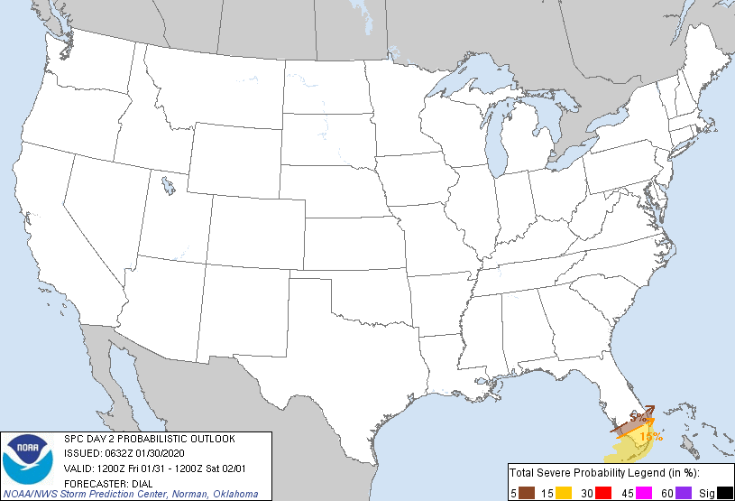
Morgen zijn de verwachting nog wat slechter voor Oklahoma, Arkansas & Texas (max 5% kans op tornado's):
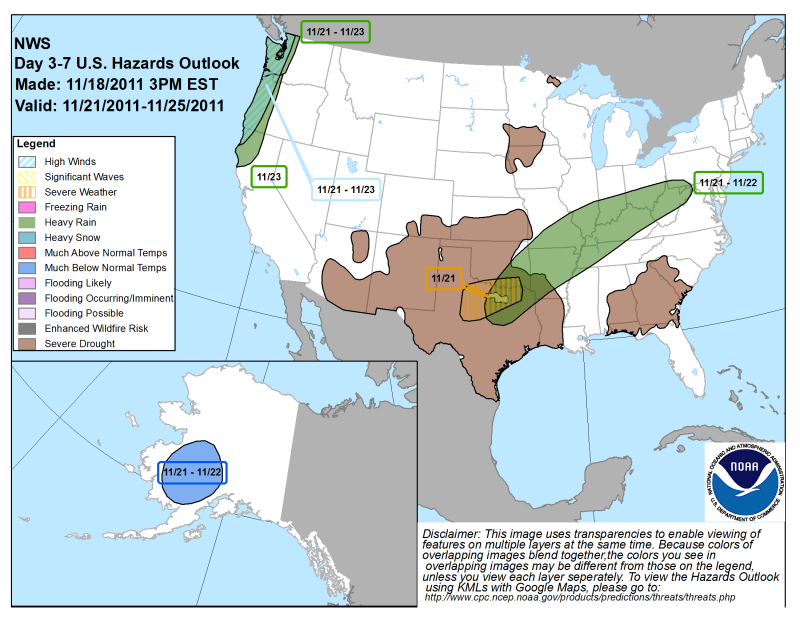
Overmorgen trekt het allemaal naar het oosten (kaartje uitgedrukt in slecht weer):
Morgen zijn de verwachting nog wat slechter voor Oklahoma, Arkansas & Texas (max 5% kans op tornado's):

Overmorgen trekt het allemaal naar het oosten (kaartje uitgedrukt in slecht weer):
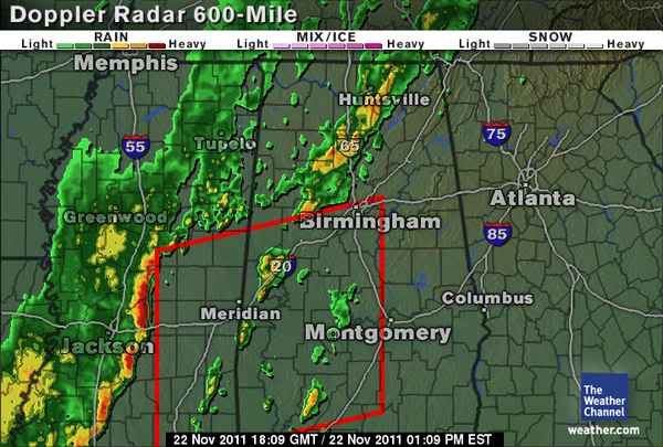


quote:MESOSCALE DISCUSSION 2390
NWS STORM PREDICTION CENTER NORMAN OK
1122 AM CST THU DEC 22 2011
AREAS AFFECTED...SERN MS / SWRN AL
CONCERNING...TORNADO WATCH 899...
VALID 221722Z - 221815Z
THE SEVERE WEATHER THREAT FOR TORNADO WATCH 899 CONTINUES.
TORNADO RISK WILL LOCALLY BE MAXIMIZED AS/IF STORMS MATURE INTO
SUPERCELLS AS THEY MOVE NEWD FROM SERN MS/FAR SWRN AL INTO SWRN AL.
SUPERCELLS THAT DEVELOP AHEAD OF APPROACHING SQUALL LINE WILL POSE
THE GREATEST RISK FOR TORNADO/S.
MESOSCALE ANALYSIS PLACES AN INCREASINGLY MOIST/DESTABILIZING WARM
SECTOR ACROSS SERN MS INTO THE SWRN QUARTER OF AL. TEMPS IN THE LOW
70S WITH UPPER 60S DEWPOINTS WILL OFFSET A MARGINAL LAPSE RATE
PROFILE AS STORMS DEVELOP/MOVE NEWD THE NEXT FEW HOURS. KMOB VAD
SHOWS 350 MS/S2 0-1 KM SRH WITHIN A STRONGLY SUPPORTIVE SUPERCELL
WIND PROFILE. GIVEN MODESTLY IMPROVING THERMODYNAMIC SETUP
COINCIDENT WITH THE DIURNAL CYCLE...EXPECTING A LOCALIZED HIGHER
THREAT FOR A TORNADO OR TWO /PERHAPS SIGNIFICANT/ WITH ANY
LONG-LIVED SUPERCELLS THAT DEVELOP/PERSIST AHEAD OF ADVANCING SQUALL
LINE THE NEXT FEW HOURS ACROSS SWRN AL.

Houston we've got a problemtwitter:txstormchasers twitterde op maandag 09-01-2012 om 15:59:16 #TORNADO WARNING for Harris County until 9:45 AM. This DOES INCLUDE THE CITY OF HOUSTON. #txwx #severe reageer retweet

Damn dat gaat nog steeds lekker he daar 
<a href="https://www.youtube.com/channel/UCPueUwKfPaGH7v48LZlltkg" rel="nofollow" target="_blank">WSDokkum Youtube</a>

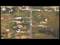
quote:Strong storms spin tornado, flood streets
Strong storms pounded the Houston area on Monday, flooding streets, spawning a tornado and dropping hail.
Severe thunderstorm warnings, flash flood warnings and flood advisories remain issued for southeast Texas counties.
"Whenever a thunderstorm is strong enough to produce hail, it's strong enough to produce a tornado. They almost go hand-in-hand" KPRC chief meteorologist Frank Billingsley said. "These heavy rains continue to push across Houston and into the east at 25 mph. Four inches of rain has been common south of Interstate 10. Although there's not much behind this system, we're going to continue to deal with this until 1 o'clock."
Fort Bend County was hit the hardest.
Sugar Land recorded the most rain with 6.20 inches as of noon. Katy had 4.36 inches. Pearland logged 3.88 inches and Houston had 4.20 inches of rain.
"We've got a lot of lightning with this system and that's also a big danger," KPRC meteorologist Anthony Yanez said. "There's a lot of heavy rain."
A tornado touched down in Fort Bend County along FM 1093 and FM 723 shortly after 9:30 a.m. The Sheriff's Office said power lines and trees were down in the area.
Beverly Moore heard the tornado approach her house on FM 723.
"All the doors in the house were trying to open and shut. It sounded like a train going through, so we hid in the closet," she said. "It was definitely a tornado. We hid for about 15 minutes."
"We've heard of roof damage in a neighborhood," said a spokesman with the Fort Bend County Sheriff's Office. "There's been quite a bit of flooding. There's been some hail but we haven't heard anything about injuries."
Several homes in the Kingsbridge Place neighborhood in Fort Bend County were severely damaged by the storms.
Bricks, wood and shingles were torn off houses and garage doors were twisted and bent.
"I was actually sleeping when it all happened," one of the residents said. "All you hear is it starts raining harder and you can feel the wind pushing inside the house. Then the door flies open and the ceiling starts leaking."
A neighbor said they did not know what was happening.
"We thought it was like an earthquake or tornado," he said. "At my house, a piece of wood came through the wall. The wall didn't collapse, but a piece of wood came right through it. We're lucky to be alive."
The Richmond Fire Department helped residents evacuate around Third Street as water crept into houses.
"We've had reports of water in homes," said Alan Spears with the Fort Bend County Office of Emergency Management. "We had some boat evacuations going on.
A funnel cloud was spotted on Highway 99 shortly after 9 a.m., but there were no reports of it touching down.
Afternoon pre-kindergarten classes were canceled for the Lamar Consolidated Independent School District.
The floodwaters were receding in the area of Highway 6 and Bissonnet about 11 a.m., but it was still knee-high in the middle of some area streets.
High water was reported on freeways across the city. There were at least 15 locations where water impeded freeway traffic at midday.
The main lanes of state Highway 288 near Holly Hall were impassible and drivers tried to turn around in the median, but they did not get very far because the other side of the road was also flooded.
Officials recommend drivers stay off the roads unless absolutely necessary.
"It only takes about 6 inches (of water) to knock a person over," said Michael Walter of the Houston Office of Emergency Management. "It only takes about 2 feet of water to wash away an SUV."

twitter:reedtimmerTVN twitterde op maandag 09-01-2012 om 20:47:01 MAJOR flooding in the Houston area! Andy Gabrielson and Mike Scantlin sent me this photo near the intersection... http://t.co/sKP3CUiE reageer retweet
 MAJOR flooding in the Houston area! Andy Gabrielson and Mike Scantlin sent me this photo near the intersection...
You better lose yourself in the music
The moment, you own it, you better never let it go
The moment, you own it, you better never let it go
In Houston is die flat geimplodeerd toch?quote:Op maandag 9 januari 2012 16:01 schreef Frutsel het volgende:
Houston we've got a problemtwitter:txstormchasers twitterde op maandag 09-01-2012 om 15:59:16 #TORNADO WARNING for Harris County until 9:45 AM. This DOES INCLUDE THE CITY OF HOUSTON. #txwx #severe reageer retweet
"We meet every day at the same cafe, six-thirty and no one knows she'll be there."
Ik heb er nog geen nieuwsartikelen over kunnen vinden.quote:
[..]
In Houston is die flat geimplodeerd toch?
Hier wel twee video's van de overstromingen.
You better lose yourself in the music
The moment, you own it, you better never let it go
The moment, you own it, you better never let it go
quote:Tornado damages Mall of the Mainland in Texas City
Damage from a tornado closed the Mall of the Mainland in Texas City this afternoon. A twister hit the shopping center around 1:30 p.m. Shortly thereafter, the Texas City fire marshal evacuated the building. "We had a report of a tornado that hit the mall," said Texas City Fire Chief Joe Gorman. "They are pretty busy out there trying to secure the property." It is unclear whether there were any injuries, but employees and shoppers were ordered out of the shopping center. "The structural integrity of the building has been compromised from the tornado hit and we are making sure people are out of the mall," Gorman added. Michael Pariza, president of Boxer Retail, which manages the property, said company officials are assessing the damage. "It appears a large windstorm/tornado - not sure which - hit the mall. It damaged some skylights, tore off a roll up gate in one of the loading docks and damaged part of the roof – the tilt arcade space adjacent to the movie theater." The Mall of the Mainland is anchored by Macy's, Sears and Palais Royale department stores. Tenants also include a theatre along with roughly 50 other smaller shops.


quote:Storms injure 15 in North Carolina
At least 15 people were injured and at least 60 buildings damaged when a possible tornado struck in western North Carolina, the National Weather Service said Thursday.
The storms struck in Rutherford and Burke counties late Wednesday afternoon as a cold front moved through the western Carolinas, meteorologist Neil Dixon with the weather service office in Greer, S.C., said.
Ten people were hurt in Ellenboro in Rutherford County, sheriff's Sgt. Dwayne Wright said. Two of the injuries were serious, but Wright did not know the extent of the injuries.
At least 10 buildings were damaged in a 3-square-mile residential area, but Wright said officials expected to get a better count on the damage during surveys Thursday.
Some people initially were trapped in their homes.
"Everybody's out that we know of," Wright said. "As far as we know, everybody has been accounted for."
A woman in Ellenboro told WCNC-TV that a neighbor's roof ended up in her front yard.
Midwest Snow Storm Turns Deadly
Ik denk dat ik morgen wat later op m'n werk verschijn. Er wordt nogal wat sneeuw verwacht.
Ik denk dat ik morgen wat later op m'n werk verschijn. Er wordt nogal wat sneeuw verwacht.

Patience is not one of my virtues, neither is memory. Or patience for that matter.
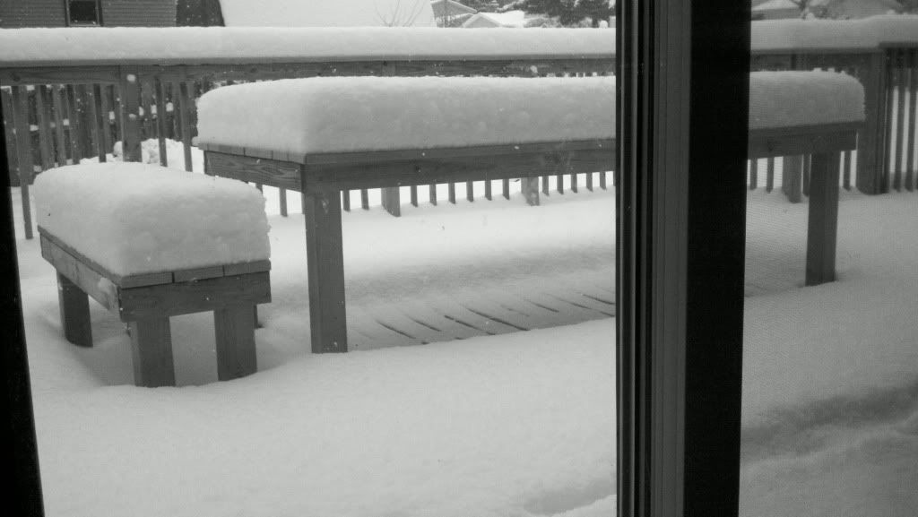
Dat was vanochtend. Er is ondertussen nog een cm of 20 bijgekomen.
Patience is not one of my virtues, neither is memory. Or patience for that matter.
Hier ongeveer. Lake effect, altijd leuke weersverrassingen.quote:
Alaska maar ff eigen topic gegeven
Sneeuwmuren van tien meter hoog in Alaska
waar zit jij Popolon?
Patience is not one of my virtues, neither is memory. Or patience for that matter.
Lijkt me een toffe locatie... Nooit geweest helaas. Volgens mij kan het in Chicago aardig spokenquote:
[..]
Hier ongeveer. Lake effect, altijd leuke weersverrassingen.
Ik moet zeggen dat ik direct moest denken aan het spel RailRoad Tycoon 2 waarbij ik standaard begon met een treinverbinding tussen Chicago en Detroit
quote:Reed Timmer: Meteorologist and Extreme Storm Chaser
New tornado warning just southwest of Nashville, TN. Should move south of the metro. Very strong rotation and moving rapidly east at 65 mph. Hickman, Maury, and Williamson Counties.

quote:THE NATIONAL WEATHER SERVICE IN NASHVILLE HAS ISSUED A
* TORNADO WARNING FOR... SOUTHERN DAVIDSON COUNTY IN MIDDLE TENNESSEE... NORTHWESTERN RUTHERFORD COUNTY IN MIDDLE TENNESSEE... NORTHEASTERN WILLIAMSON COUNTY IN MIDDLE TENNESSEE...
* UNTIL 130 PM CST
* AT 1255 PM CST... NATIONAL WEATHER SERVICE DOPPLER RADAR INDICATED A SEVERE THUNDERSTORM CAPABLE OF PRODUCING A TORNADO. THIS DANGEROUS STORM WAS LOCATED 5 MILES SOUTHWEST OF FOREST HILLS... OR 8 MILES NORTHWEST OF FRANKLIN... AND MOVING EAST AT 50 MPH.
* LOCATIONS IMPACTED INCLUDE... BELLE MEADE... FOREST HILLS... BRENTWOOD... OAK HILL... LA VERGNE AND BERRY HILL.
PRECAUTIONARY/PREPAREDNESS ACTIONS...
THIS LINE OF THUNDERSTORMS IS CAPABLE OF PRODUCING TORNADOES AND WIDESPREAD SIGNIFICANT WIND DAMAGE. DO NOT WAIT TO SEE OR HEAR THE TORNADO. FOR YOUR PROTECTION MOVE TO AN INTERIOR ROOM ON THE LOWEST FLOOR OF YOUR HOME OR BUSINESS