WKN Weer, Klimaat en Natuurrampen
Lees alles over het onstuimige weer op onze planeet, volg orkanen en tornado's, zie hoe vulkanen uitbarsten en hoe Moeder Aarde beeft bij een aardbeving. Alles over de verwoestende kracht van onze planeet en tal van andere natuurverschijnselen.


quote:Op donderdag 27 oktober 2011 10:10 schreef Keiichi het volgende:
Ik had vanacht gedroomd dat er onder El Hierro een gigantische magmakamer zou zitten en dat het een geluk is dat er voor de kust maar zo'n kleine uitbarsting is
misschien heb je een ander bericht ook gelezen en de zaken snachts gemengd?
Zoals deze
Scientists worry about fast inflating new (super)volcano in Bolivia
Nope, eerste keer dat ik dat bericht zie.
Ik denk eerder dat m'n kop iets met die 3d image van alle aarbevingen mee probeerde te doen. De grootte kwam iets meer daarmee over
Ik denk eerder dat m'n kop iets met die 3d image van alle aarbevingen mee probeerde te doen. De grootte kwam iets meer daarmee over
quote:Scientists detect that there is magma beneath El Hierro
The research vessel 'Ramon Margalef' plunge the two robots to take the first real images of cone 100 meters in the sea of las Calmas
CMM Researcher National Geographic Institute (IGN) Joan Martí said yesterday that have proven "very clearly" that magma remains under El Hierro 20 to 25 meters deep and said that the eruption is still ongoing. The researcher was speaking at a press conference within the research vessel Ramón Margalef, robots that immerses today Liropus 2000 and a photogrammetric sled to take the first real images of the eruptive fissure and cone height of 100 meters in Las Calmas.
Marti said that the eruption began in the north and the magma traveled 12 kilometers beneath the island he found out south of La Restinga. The expert noted that "the gas outlet and the seismic signal indicates that the eruption continues," and virtually ruled out a similar eruption in Frontera, where earthquakes are occurring in the last hours, but "continue to monitor." IGN investigator considered "surprising" that the volcano is behaving like a subaerial eruption, despite being underwater.
The two robots that will try today take pictures and videos of the volcano El Hierro from the vessel Ramón Margalef. This was announced by Juan Acosta, a researcher at the Spanish Institute of Oceanography (IEO). Apparently, the turbidity of the water over the mouth of the eruption, the exit of materials, will be difficult to obtain these first real images of the cone, so that scientists plan to begin in El Golfo and gradually get closer the main focus.
The Ministry of Science and Innovation released on Tuesday showed a cartographic approach, in addition to the eruptive fissure, a cone-ups, 100 meters high, with a mouth width of 120 meters, 300 meters deep. "Drawing on the bathymetry (depth map) of this area, conducted in 1998, the Navy Hydrographic Institute and the IEO, we see that in this area I had before was a valley, a valley, where there is now a cone height of 100 meters, "said Acosta.
Joan Martí recommended a new bathymetry within a time to check for changes in morphology of the building. "These structures are very unstable, as they grow, collapse, and will be watched to see what state they are," he said.
Francisco Sanchez of the IEO, added that it is fortunate to have reached a stage where the eruption is not "excessively violent" because it allowed them to pass "just above" the mouth and make the corresponding measurements.
Without oxygen
Joan Martí also revealed that the dead fish may have suffered a shock as it has been found that in the area of the spot had "zero oxygen", which is called anoxia.
quote:El Hierro : Volcano cone has 12 Mln Cu Mt capacity
Scientists from the oceanographic research vessel 'Ramon Margalef' have completed their mapping of the seabed surrounding the volcanic eruption on El Hierro, and are prpearing to deploy their research submarine to relay images of the fissure to the surface for further analysis.
The underwater cone, which was discovered on Monday, has an estimated capacity of 12 Million cubic meters and could produce a volume of 40 Million Cubic Meters of magma, and with a flow of lava over several Km with a volume of 2 Million Cubic Meters - a significant amount given that the eruption only began on the 9th Oct.
The new cone lies some 300 meters below the surface and has a base diameter of 700 meters, a height of 100 meters and with a crater width of about 120 meters. The lava becomes solid once it comes into contact with the cool seawater, forming a crust on the surface, but remaining liquid inside, and moving slowly across the seabed until the inside of the trail eventually cools and solidifies.
The role of the reserach scientists on the surface is to gather the information and relay it to the PEVOLCA commitee and the National Geograhic Institite (IGN).
Further analysis will follow in 3 phases : the remotely operated submarine will take high resolution images of the eruption; a Sled will be used to take further images from different altitudes and angles; and finally, the water / gas colum eminating from the eruption will be analysed. The results of which are expected to be known by early next week.
An interesting post on Youtube this morning (if you have 15 mins to spare ! ) which probably explains why so many North Americans are concerned about the current situation in the Canary Islands (Tumbit Note : Notice that the clips jump between discussing predictions on both El Hierro AND La Palma) >>>


[ Bericht 15% gewijzigd door bwt op 27-10-2011 15:26:39 ]
<a href="http://goo.gl/q8fhTe" target="_blank">FAQ?</a>
<a href="http://goo.gl/gYvZFq" target="_blank">Geel is een zonnige en vrolijke kleur, als hij tenminste enigszins warm is gekleurd en wat naar het oranje neigt</a>
<a href="http://goo.gl/gYvZFq" target="_blank">Geel is een zonnige en vrolijke kleur, als hij tenminste enigszins warm is gekleurd en wat naar het oranje neigt</a>
quote:Hello
Although I have no university degree, i have been educated in the field in 1965 by the great Haroun Tazieff, I started to carry his bag and all I learned was coming from Haroun. I am following volcanoes for more then 45 years and I am now in El Hierro … and I am following day by day the evolution of the seismicity of the volcano island
Earthquake-Report.com wrote earlier:
“Most people in El Hierro were happy to hear that the new crater was finally found and appear to be too happy with the birth of new baby”
But what are they talking about ! … this crater has been around for decades and it is located 3/4 miles south-south-west of La Restinga and rises from a depth of more or less -370 meter. I have given the location of this crater already in an article i wrote on 28/09/2011.
The new crater is located 2 km from the south-west coast of El Hierro at a depth of 150 meters … the water temperature is above 60°C and the Ramon Margalef can unfortunately NOT use his ROV in water at temperatures above 30°C (risk of destruction or important damage) …
The volcano presented by the Ramon Margalef is not the new volcano. The other parts of the picture are not showing signs of an recent eruption … In addition, the new vent culminates at a very shallow depth of 70 m. Contrary to what a lot of people and scientists are telling i have to stress that the Jacuzzi is still working. Also small geysers, stage 2 of an eruption surtseyenne, are appearing …
I am here on the island and i can see this from my viewing point …
Finally, from a volcanic point of view, it is normal that the earthquakes are shifting towards El Julan and El Golfo. Depth close to 20 km, they show that the magma is travelling towards the eruptive vent / fissure … the GPS data and seismograms are in constant evolution n and the ground at El Golfo, El Julan and in the Sea of Las calmas …
quote:A surtseyenne type eruption : What risks to El Hierro?
In addition to the volcanic tremor perpetuates an underwater eruption since 10 October 2011 to 04 17 pm Universal Time, the Instituto Nacional Geográfico - IGN - recorded from October 17 A 01 H 29 Universal Time on October 18, 2011 57 to 00 h Universal Time, 8 new seismic events in the Sea of Las Calma - including 5 in the basal zone eruption in the south-west of La Restinga, and 3 in the West - with a magnitude between 1.5 mbLg and 2.5 and hypocenter ranging between 12 and 30 km focal depth, off the coast of South-East of the island-volcano El Hierro.
On October 17, 2011, following three earthquakes of magnitude greater than 2.0 mbLg:
- The first 07 to 07 h Universal Time, latitude and longitude 27.6873 ° N 18.0374 ° W, 13 km deep hypocenter, magnitude mbLg 2.1;
- The second 55 to 12 h Universal Time, latitude and longitude 27.6645 ° N 18.0448 °, west 16 km deep hypocenter, magnitude mbLg 2.5;
- The third 12 to 18 h Universal Time, latitude and longitude 27.6629 ° N 18.0758 ° W, 18 km deep hypocenter, magnitude mbLg 2.2;
the spectrogram, a major significant change in the volcanic tremor and, consequently, in the eruptive process, has suddenly packed 12 to 19 hours Universal Time.
Two theories can be made:
- A new eruptive vent opened, within the perimeter defined by five seismic hazard cited above, between 150 and 300 meters deep, on the northwest flank of the volcano underwater peaked at 4 / 5 km southwest of La Restinga to -370 meters;
- The volcanic cone of the vent had appeared off the coast of Puerto Naos, 150 meters deep, is close to the ocean level.
In the first case, clear signs, in a few hours, will confirm or deny. But if a new fissure has really opened the first signs that indicate, will be on the one hand, a gradual decrease of volcanic tremor accompanied by a deflation of the ground - no doubt, then, that some scientists interpret it, not as the opening of a new vent, but the underwater volcanic eruption gradually draws to a close, unless a temporary lull, it was nevertheless not be excluded if périclitent volcanic swarms - and, secondly, the gradual disappearance of the hot spot and the resurgence of progressive giant bubbles become less frequent over time.
In the second, the vent was opened to very shallow - 150 meters - the magma flows, pillow lavas forming, it could be no doubt that the volcanic edifice is being built near reaching the surface. Since October 16, giant gas bubbles occur every 15 minutes, overlooking the eruption site. These were the beginnings of a hot spot visible from Puerto Naos and Punta de la Restinga. And high boiling points out that the top part of the new building is sub-flush and the appearance of a plume cyprissoîde, surtseyenne herald an eruption could be imminent.
What risks as part of an eruption surtseyenne?
Surtseyenne type eruption is a type of volcanic eruption that occurs in shallow seas or lakes within 100 meters. It was observed for the first time, Capelinhos, the Azores, from 1957 to 1958, but the emergence of Surtsey, south of Iceland between 1963 and 1967, which gave it its name. These eruptions are eruptions hydromagmatic interacting with violent explosions, more violent than if they occurred on land, caused by andesitic or basaltic magma at a temperature of 1200 ° C, in contact with the shallow water environment or surface water, frequently less than 20 ° C. Water expands and turns into steam, and in contact with the magma, its expansion releases energy that quenches and shatters. It explodes and creates plumes of ash, steam and slag.
The explosive expansion of steam occurs near the surface in an open vent where water pressures and temperatures are relatively low, and where energy can be dispersed during eruptions of variable intensity , repeated at intervals of several minutes that can last many months. Explosions superficial provoquenr collapse of walls at the top of the vent pipe and developing a funnel-shaped
The activity builds hydromagmatic téphraïques surfaces of several square kilometers in the first few months. When the sea water can no longer reach the eruptive vent and lava, the eruption becomes Hawaiian or Strombolian type. The explosions and offshore create plumes of ash and steam that rise to over 4 / 5 kilometers, or 8 to 10 km altitude, and clouds of several hundred meters high of tephra. It results in the formation of tuff rings and pyroclastic cones.
While the surtseyennes eruption generate spectacular explosions that are much less dangerous than leaving to assume their appearance. The coasts of the Atlantic Ocean recellent many cones surtseyens such as Monte Brasil in Terceira, and Monte Guia, Faial, Azores, El Golfo, Lanzarote, and Taco, in Tenerife, Canary Islands ...


<a href="http://goo.gl/q8fhTe" target="_blank">FAQ?</a>
<a href="http://goo.gl/gYvZFq" target="_blank">Geel is een zonnige en vrolijke kleur, als hij tenminste enigszins warm is gekleurd en wat naar het oranje neigt</a>
<a href="http://goo.gl/gYvZFq" target="_blank">Geel is een zonnige en vrolijke kleur, als hij tenminste enigszins warm is gekleurd en wat naar het oranje neigt</a>

quote:27/10/2011 @ 16:36 So far today there have been 26 earthquakes on El Hierro measuring over 1.5° on the Richter scale, two of them have been over 3° at 06:27 and 14:02.
<a href="http://goo.gl/q8fhTe" target="_blank">FAQ?</a>
<a href="http://goo.gl/gYvZFq" target="_blank">Geel is een zonnige en vrolijke kleur, als hij tenminste enigszins warm is gekleurd en wat naar het oranje neigt</a>
<a href="http://goo.gl/gYvZFq" target="_blank">Geel is een zonnige en vrolijke kleur, als hij tenminste enigszins warm is gekleurd en wat naar het oranje neigt</a>

Alle recente bevingen zitten wel erg diep.

<a href="http://goo.gl/q8fhTe" target="_blank">FAQ?</a>
<a href="http://goo.gl/gYvZFq" target="_blank">Geel is een zonnige en vrolijke kleur, als hij tenminste enigszins warm is gekleurd en wat naar het oranje neigt</a>
<a href="http://goo.gl/gYvZFq" target="_blank">Geel is een zonnige en vrolijke kleur, als hij tenminste enigszins warm is gekleurd en wat naar het oranje neigt</a>
quote:28/10/2011 @ 09:19 – New 3D video released by the Ministerio de Ciencia e Innovación showing shape and form of the underwater volcano on El Hierro.
<a href="http://goo.gl/q8fhTe" target="_blank">FAQ?</a>
<a href="http://goo.gl/gYvZFq" target="_blank">Geel is een zonnige en vrolijke kleur, als hij tenminste enigszins warm is gekleurd en wat naar het oranje neigt</a>
<a href="http://goo.gl/gYvZFq" target="_blank">Geel is een zonnige en vrolijke kleur, als hij tenminste enigszins warm is gekleurd en wat naar het oranje neigt</a>


3.3
Bevingen gaan gewoon door.
Zou er echt een uitbartsing zijn/komen in zee boven Frontera?
Nieuwe NASA Foto van El Hierro en andere vulkanen.

[ Bericht 21% gewijzigd door bwt op 28-10-2011 16:50:44 ]
<a href="http://goo.gl/q8fhTe" target="_blank">FAQ?</a>
<a href="http://goo.gl/gYvZFq" target="_blank">Geel is een zonnige en vrolijke kleur, als hij tenminste enigszins warm is gekleurd en wat naar het oranje neigt</a>
<a href="http://goo.gl/gYvZFq" target="_blank">Geel is een zonnige en vrolijke kleur, als hij tenminste enigszins warm is gekleurd en wat naar het oranje neigt</a>
Hier een beter/scherper plaatje dan hierboven
https://twitter.com/#!/teideano/status/130062213326180353
https://twitter.com/#!/teideano/status/130062213326180353
<a href="http://goo.gl/q8fhTe" target="_blank">FAQ?</a>
<a href="http://goo.gl/gYvZFq" target="_blank">Geel is een zonnige en vrolijke kleur, als hij tenminste enigszins warm is gekleurd en wat naar het oranje neigt</a>
<a href="http://goo.gl/gYvZFq" target="_blank">Geel is een zonnige en vrolijke kleur, als hij tenminste enigszins warm is gekleurd en wat naar het oranje neigt</a>
3.6=>
29/10/2011 15:04:48 27.8154 -18.0343 23 III 3.6 4 NW FRONTERA.
Een beste ...
29/10/2011 15:04:48 27.8154 -18.0343 23 III 3.6 4 NW FRONTERA.
Een beste ...
Crazy as Always...met vleugels natuurlijk..;-0
Stevige inderdaad.
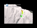
Tot nu to vandaag 139 geregistreerde bevingen
Verspreiding aardbevingen laatste 2 dagen.
[ Bericht 31% gewijzigd door bwt op 29-10-2011 19:13:56 ]
Tot nu to vandaag 139 geregistreerde bevingen


Verspreiding aardbevingen laatste 2 dagen.

[ Bericht 31% gewijzigd door bwt op 29-10-2011 19:13:56 ]
<a href="http://goo.gl/q8fhTe" target="_blank">FAQ?</a>
<a href="http://goo.gl/gYvZFq" target="_blank">Geel is een zonnige en vrolijke kleur, als hij tenminste enigszins warm is gekleurd en wat naar het oranje neigt</a>
<a href="http://goo.gl/gYvZFq" target="_blank">Geel is een zonnige en vrolijke kleur, als hij tenminste enigszins warm is gekleurd en wat naar het oranje neigt</a>
hmm.. Ik vlieg later deze week naar Lanzarote. Moet ik me zorgen gaan maken? (ben een geologische leek, dus snap de helft in deze thread niet)
We privileged few, who won the lottery of birth against all odds, how dare we whine at our inevitable return to that prior state from which the vast majority have never stirred?
Lanzarote ligt compleet aan de andere kant van het archipel, je hoeft je echt geen zorgen te maken. Dit is het type lava dat geen (grote) explosies geeft.


<a href="http://goo.gl/q8fhTe" target="_blank">FAQ?</a>
<a href="http://goo.gl/gYvZFq" target="_blank">Geel is een zonnige en vrolijke kleur, als hij tenminste enigszins warm is gekleurd en wat naar het oranje neigt</a>
<a href="http://goo.gl/gYvZFq" target="_blank">Geel is een zonnige en vrolijke kleur, als hij tenminste enigszins warm is gekleurd en wat naar het oranje neigt</a>
quote:El Hierro update : Sat 29th October
Seismic activity on the Island of El Hierro intensified yesterday, with a total of 63 earthquakes being recorded by the National Geographic Institute (IGN), with an average depth of 20km and magnitudes of up to 3.3 on the richter scale, off the North-West coast of the Island.
Of the 63 quakes, 4 were recorded above 3.0, 27 between 2.0 and 3.0 with the remainder being below 2.0.
Over the past week dozens of similar quakes have been recorded in the same area - the opposite side of the Island to where the volcanoi eruption is being observed off the coast of La Restinga.
So far today the IGN has recorded 32 earthquakes, mainly around the El Golfo area, with the largest one being recorded this morning with a 3.3 magnitude.
The movements could indicate a likely change in magma flows deep underground, but scientists are still unable to say if this will result in a change of eruptive phase to the existing underwater volcano, or if a further eruption may occur.
Thel Ramon Margalef Oceanographic research ship is continuing to monitor the situation and has surveyed the underwater eruption off the south coast of the island tocheck for any changes in activity. A new Volcanic crater was discovered earlier this week 300mt below the surface measuring some 100mt high, with a cone diameter of 700mt and a crater width of 120mt. Geologists estimate that it has a cubic capacity of 12 Million Meters and could potentially produce as much as 40 Million cubic meters of magma.
Underwater lave flows have now reached 7km - the magma solidifies on the outside as it comes into contact with the cold seawater, but remains liquid and continues to flow at it's core.

<a href="http://goo.gl/q8fhTe" target="_blank">FAQ?</a>
<a href="http://goo.gl/gYvZFq" target="_blank">Geel is een zonnige en vrolijke kleur, als hij tenminste enigszins warm is gekleurd en wat naar het oranje neigt</a>
<a href="http://goo.gl/gYvZFq" target="_blank">Geel is een zonnige en vrolijke kleur, als hij tenminste enigszins warm is gekleurd en wat naar het oranje neigt</a>
Bevingen concentreren zich wel erg sterk op 1 kleine regio
<a href="http://goo.gl/q8fhTe" target="_blank">FAQ?</a>
<a href="http://goo.gl/gYvZFq" target="_blank">Geel is een zonnige en vrolijke kleur, als hij tenminste enigszins warm is gekleurd en wat naar het oranje neigt</a>
<a href="http://goo.gl/gYvZFq" target="_blank">Geel is een zonnige en vrolijke kleur, als hij tenminste enigszins warm is gekleurd en wat naar het oranje neigt</a>
Important Update 30/10 – 07:53 UTC
- Based on all what follows Earthquake-Report.com predicts that PEVOLCA will meet very soon. Main reason : The increasing strength of the earthquakes.
- The strongest earthquake since October 8 (a M 4.4 quake at the time), now a Magnitude 3.9 quake, occurred at 07:46 this morning in the El Golfo bay. Its epicenter was close to the Frontera coast line. The 4.4 earthquake on October 8 was the start of a number of events like the beginning of harmonic tremor and the start of the green stain (eruption) soon after. The depth is still a secure 22 km. Some scientists are linking however the magma area below the El Golfo to the still continuing eruption to the south of La Restinga. These are however speculations who cannot be proofed.
- At earthquake-report.com we do not consider quakes up to Magnitude 5 as dangerous for houses, although indirect damage can be triggered by rockfall and landslides in mountainous areas like El Hierro. Authorities will certainly follow up the El Hierro landscape scars when the quakes get again to Magnitudes 4 to 5. This will be a major concern for the El Hierro authorities from now on.
- Harmonic tremor remains the same as during recent days. This may change fundamentally if the quakes continue and are getting more powerful.
- Since midnight UTC IGN listed 11 earthquakes and only 2 of them were lower then 2! The last 3 quakes had values of 3.2, 3.9 and 3.0.
- Authorities have closed the Los Roquillos tunnel out of fear of Rockfall for the 3 to 4 magnitude quakes in the beginning of the month and have reopened him last week due to the pressure of the population. Will authorities close the tunnel again ? We do not think that they will take such a decision very soon as technicians have improved some parts of the tunnel. The concern among scientists and PEVOLCA must grow though.
- Joke reported yesterday that the Frontera population reacted completely different to the earthquakes than the El Pinar and La Restinga people. More indifferently and certainly not as alerted as them.
- Those people wanting to follow the discussions among specialized volcano amateur followers can click on this link. We can warmly advise it. A lot of scenarios are being discussed.
http://www.jonfr.com/volcano/?p=1716
Er is idd wat aan het handje daaro in El Hierro. Dussss......wachten op bevestiging.quote:The current tremor data now suggests that a new vent or vents have opened or are about to open up just outside north-west coast of El Hierro volcano. The depth where the main earthquakes have been taking place is about 100 to 300 meters (but might be more). So far the largest earthquakes to take place in this area was a ML3.9 with the depth of 22 km. What is important in this is not the fact that the earthquakes are at great depth. But also the fact that a more shallow might not take place. As that was not the case when the eruption started in El Hierro on 10 October, 2011. It is unlikely that there is going to be any shallow earthquake activity before a new eruption vents opens up. As that was not the case on the 10 October, 2011 from what I can remember.
I am not sure how strong earthquake this area can make. But I am guessing that it might well be in the upper Mb5.5+ range. The earthquakes that are now taking place are due to magma injection. Not a tectonic one. There is a difference between the two. But this rifting in El Hierro might trigger a earthquake close to El Hierro Island in near future, that earthquake would be a tectonic one. Not a earthquake created by magma movements.
So far the new vents are still unconfirmed. But there are signs in the harmonic tremor data that new eruption vents might be opening up or have already opened up. But at this moment I am waiting for a confirmation on this actually taking place. That is going to take a few hours, given the experience so far.
Crazy as Always...met vleugels natuurlijk..;-0

Die was inderdaad langdurig.

<a href="http://goo.gl/q8fhTe" target="_blank">FAQ?</a>
<a href="http://goo.gl/gYvZFq" target="_blank">Geel is een zonnige en vrolijke kleur, als hij tenminste enigszins warm is gekleurd en wat naar het oranje neigt</a>
<a href="http://goo.gl/gYvZFq" target="_blank">Geel is een zonnige en vrolijke kleur, als hij tenminste enigszins warm is gekleurd en wat naar het oranje neigt</a>
