WKN Weer, Klimaat en Natuurrampen
Lees alles over het onstuimige weer op onze planeet, volg orkanen en tornado's, zie hoe vulkanen uitbarsten en hoe Moeder Aarde beeft bij een aardbeving. Alles over de verwoestende kracht van onze planeet en tal van andere natuurverschijnselen.


Update 02/10 22:12 UTC : After a period of relative calm the stronger earthquakes started again around Sunday noon (UTC). We have observed 18 volcanic earthquakes of equal or more of Magnitude 2. The strongest one measured 3.7 ML. 5 earthquakes exceeded ML 3.0. NO change in the depth of the hypocenters. The Canary Island authorities have no real news, they just stated that the "Yellow Alert" is maintained. This situation can go on for many days even many weeks. Earthquake-report.com will keep an eye on what happens and will report it in this article if something significant develops.
[ Bericht 6% gewijzigd door blids op 03-10-2011 14:15:45 ]

[ Bericht 6% gewijzigd door blids op 03-10-2011 14:15:45 ]
En waarop baseren ze dat dan?quote:Op zondag 2 oktober 2011 23:12 schreef Keiichi het volgende:
De aardbevingen die er zijn, lijken in zuidelijke richting te trekken.
-edit-
Er zijn trouwens wel een hoop mensen die denken dat El Hierror net zo'n landslide kan veroorzaken als ze denken dat op La Palma zou gebeuren
Inorbit: zeg dat dan typluie triangeljosti
Beauregard: Een beetje FOK!ker laat het brood door z'n moeder smeren.
Ecosia
ek's 'n flash drive, jy's 'n floppy
Beauregard: Een beetje FOK!ker laat het brood door z'n moeder smeren.
Ecosia
ek's 'n flash drive, jy's 'n floppy
Verleden misschien?quote:
[breaking] Vulkaanuitbarsting op Canarische Eilanden op komst?
Al vaker aardverschuivingen geweest daar. Ook met tsunami
quote:2011-10-03 10:54:15.31hr 32min ago 27.64 N 18.07 W 17 2.8 CANARY ISLANDS, SPAIN REGION
2011-10-03 10:27:49.61hr 58min ago 27.63 N 18.07 W 14 2.7 CANARY ISLANDS, SPAIN REGION
2011-10-03 10:14:43.42hr 12min ago 27.63 N 18.08 W 15 3.4 CANARY ISLANDS, SPAIN REGION
Nee helaas. Ik ben overledenquote:
 Op
Op Mijn Spaans is bar slecht, dus de pers volgen levert niet veel op. Al is het natuurlijk ook zo dat ALS er iets groots zou gebeuren, dat ook wel groots in het nieuws komt. Niets van dat al.
29 graden, cocktails, zon, palmen, strand. Geen aardbevingen
Acquisitie n.a.v. deze post wordt niet op prijs gesteld.
Don't you see going to heaven is just in the thought that you might?
As an on-line radio program grows longer, the probability of a German song approaches 1.
Don't you see going to heaven is just in the thought that you might?
As an on-line radio program grows longer, the probability of a German song approaches 1.
Magma on the move in El Hierro, Canary Islands
Update 3 October 2011
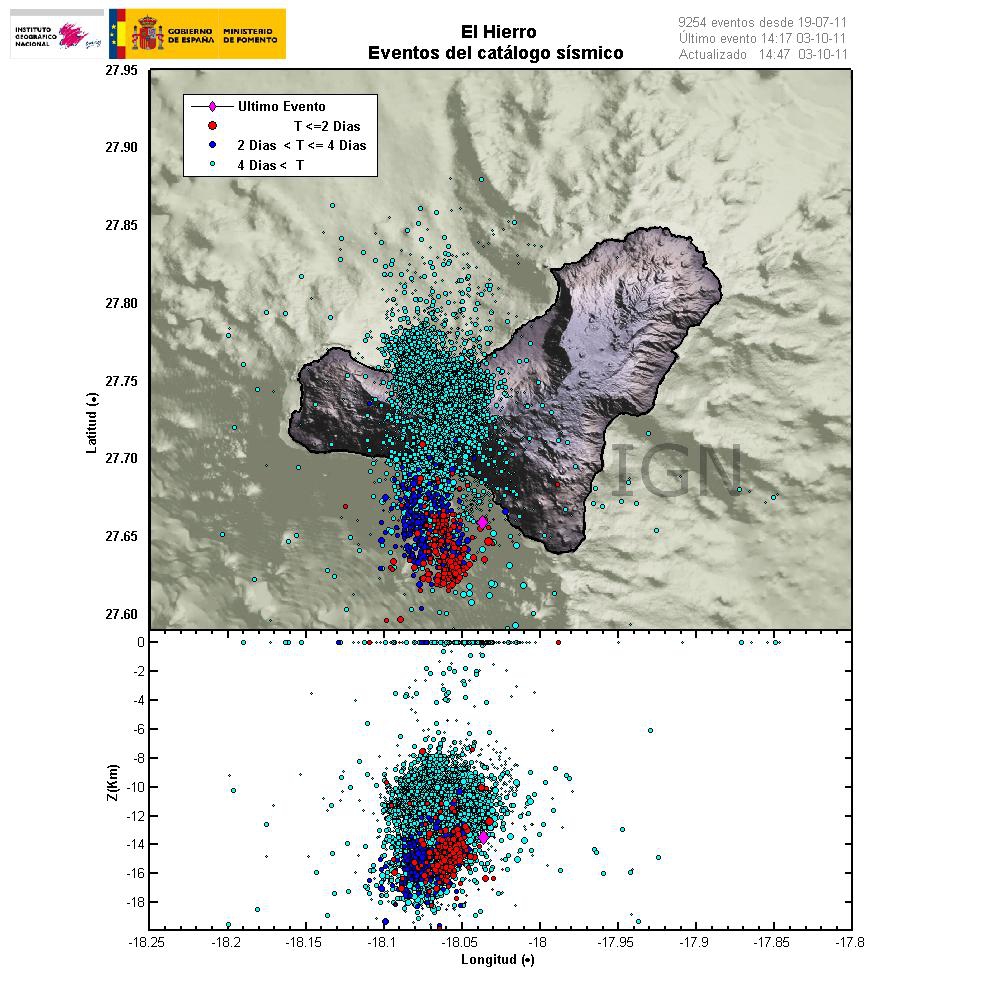
This is happening faster then I expected. But it seems that magma is now on the move upwards in El Hierro volcano in Canary Islands. This is evident by the earthquake patterns that are emerging from the volcano. Given the earthquake locations, most likely place for a eruption to take place is out on the ocean based on that. But sometimes magma can find different pathways up the surface without a lot of warning.
Latest earthquake map from Instituto Geográfico Nacional that shows clearly the earthquake pattern since the dike intrusion did start in El Hierro. Copyright of this picture belongs to Instituto Geográfico Nacional.
At the moment it is impossible to know when and where a eruption might start. It depends on many factors. But it is now clear that magma is on the move upwards. So far the magma seems to be around 10 km up in the earth crust under El Hierro. So it is clear that the magma is on the way up and most likely preparing for a eruption.
[ Bericht 0% gewijzigd door blids op 03-10-2011 20:38:40 ]
Update 3 October 2011
This is happening faster then I expected. But it seems that magma is now on the move upwards in El Hierro volcano in Canary Islands. This is evident by the earthquake patterns that are emerging from the volcano. Given the earthquake locations, most likely place for a eruption to take place is out on the ocean based on that. But sometimes magma can find different pathways up the surface without a lot of warning.
Latest earthquake map from Instituto Geográfico Nacional that shows clearly the earthquake pattern since the dike intrusion did start in El Hierro. Copyright of this picture belongs to Instituto Geográfico Nacional.
At the moment it is impossible to know when and where a eruption might start. It depends on many factors. But it is now clear that magma is on the move upwards. So far the magma seems to be around 10 km up in the earth crust under El Hierro. So it is clear that the magma is on the way up and most likely preparing for a eruption.
[ Bericht 0% gewijzigd door blids op 03-10-2011 20:38:40 ]
dat met tsunami haal ik er niet uit. Alleen dat er heel veel materiaalt de zee in schuift...quote:
[..]
Verleden misschien?
[breaking] Vulkaanuitbarsting op Canarische Eilanden op komst?
Al vaker aardverschuivingen geweest daar. Ook met tsunami
[..]
Inorbit: zeg dat dan typluie triangeljosti
Beauregard: Een beetje FOK!ker laat het brood door z'n moeder smeren.
Ecosia
ek's 'n flash drive, jy's 'n floppy
Beauregard: Een beetje FOK!ker laat het brood door z'n moeder smeren.
Ecosia
ek's 'n flash drive, jy's 'n floppy
Wanneer er veel materiaal de zee in zou schuiven heb je natuurlijk wel een tsunami te pakken. De vraag is dan alleen hoeveel volume verplaatst zou worden.quote:Op dinsdag 4 oktober 2011 07:03 schreef Jumparound het volgende:
[..]
dat met tsunami haal ik er niet uit. Alleen dat er heel veel materiaalt de zee in schuift...
Ik heb wel een andere vraag in een stukje hierboven staat dat de magma aan het bewegen is. Maar zitten er dan zulke grote open ruimtes in vulkanen dat daar de magma zo doorheen kan stromen?
Dat is onzin, de vraag is niet hoveel, maar HOE het materiaal de zee in schuift.quote:
[..]
Wanneer er veel materiaal de zee in zou schuiven heb je natuurlijk wel een tsunami te pakken. De vraag is dan alleen hoeveel volume verplaatst zou worden.
Ik heb wel een andere vraag in een stukje hierboven staat dat de magma aan het bewegen is. Maar zitten er dan zulke grote open ruimtes in vulkanen dat daar de magma zo doorheen kan stromen?
Jou stelling is het zelfde als "een zeebeving veroorzaakt altijd een tsunami" Iets wat niet waar is.
Je moet een bepaalde hoek hebben waaronder een groot volume in zee stort. En het materiaal moet een zekere compacte (?) waarde hebben,Er kan wel 28 km3 puin in zee storten, maar als dat over een aantal weken gebeurd.....
naja, dat bedoel ik dus
Inorbit: zeg dat dan typluie triangeljosti
Beauregard: Een beetje FOK!ker laat het brood door z'n moeder smeren.
Ecosia
ek's 'n flash drive, jy's 'n floppy
Beauregard: Een beetje FOK!ker laat het brood door z'n moeder smeren.
Ecosia
ek's 'n flash drive, jy's 'n floppy
daar lijkt het idd op... maar hoe snel stijgt dat spul? 100 meter per dag? dan hebben we over 100 dagen een uitbarsting ;-)quote:
Inorbit: zeg dat dan typluie triangeljosti
Beauregard: Een beetje FOK!ker laat het brood door z'n moeder smeren.
Ecosia
ek's 'n flash drive, jy's 'n floppy
Beauregard: Een beetje FOK!ker laat het brood door z'n moeder smeren.
Ecosia
ek's 'n flash drive, jy's 'n floppy

Energie stijgt nog steeds. Blijkbaar is grafiekje de druk die naar boven word opgebouwd (zoals Jumparound al zei, thanks nog). Op een ander forum word gezegd dat Mount St. Helens ging bij een druk van tussen de 10 en 16 (dacht ik).
quote:Magma on the move in El Hierro, Canary Islands
This is happening faster then I expected. But it seems that magma is now on the move upwards in El Hierro volcano in Canary Islands. This is evident by the earthquake patterns that are emerging from the volcano. Given the earthquake locations, most likely place for a eruption to take place is out on the ocean based on that. But sometimes magma can find different pathways up the surface without a lot of warning.
Latest earthquake map from Instituto Geográfico Nacional that shows clearly the earthquake pattern since the dike intrusion did start in El Hierro. Copyright of this picture belongs to Instituto Geográfico Nacional.
At the moment it is impossible to know when and where a eruption might start. It depends on many factors. But it is now clear that magma is on the move upwards. So far the magma seems to be around 10 km up in the earth crust under El Hierro. So it is clear that the magma is on the way up and most likely preparing for a eruption.

Volgens mij is het een opsommige van alle aarbeving.quote:
[ afbeelding ]
Energie stijgt nog steeds. Blijkbaar is grafiekje de druk die naar boven word opgebouwd (zoals Jumparound al zei, thanks nog). Op een ander forum word gezegd dat Mount St. Helens ging bij een druk van tussen de 10 en 16 (dacht ik).
Een aardbeving van 2.0 zou gelijk staan aan een energie-release van 63 MJ. Een van 3.0 al aan 360 MJ
http://en.wikipedia.org/wiki/Richter_magnitude_scale
hij telt idd "events" 9400 nu...
lijkt er op dat het een totaal aan vrijgekomen energie is.
hoewel google het vertaald als "totaal opgeslagen energie"
lijkt er op dat het een totaal aan vrijgekomen energie is.
hoewel google het vertaald als "totaal opgeslagen energie"
Inorbit: zeg dat dan typluie triangeljosti
Beauregard: Een beetje FOK!ker laat het brood door z'n moeder smeren.
Ecosia
ek's 'n flash drive, jy's 'n floppy
Beauregard: Een beetje FOK!ker laat het brood door z'n moeder smeren.
Ecosia
ek's 'n flash drive, jy's 'n floppy
Ik heb een docu gezien over die "waarschijnlijke" landslide.quote:
De aardbevingen die er zijn, lijken in zuidelijke richting te trekken.
-edit-
Er zijn trouwens wel een hoop mensen die denken dat El Hierror net zo'n landslide kan veroorzaken als ze denken dat op La Palma zou gebeuren
Zou komen omdat de bodem poreus zou zijn in de zuidelijke helft van la palma.
Die poreusheid is in de loop van de eeuwen gevuld met water. Met een beetje warmte en druk kan het daar breken en de zee in gaan.
Maar ik meen dat alleen La Palma zo poreus was.
<a href="http://goo.gl/q8fhTe" target="_blank">FAQ?</a>
<a href="http://goo.gl/gYvZFq" target="_blank">Geel is een zonnige en vrolijke kleur, als hij tenminste enigszins warm is gekleurd en wat naar het oranje neigt</a>
<a href="http://goo.gl/gYvZFq" target="_blank">Geel is een zonnige en vrolijke kleur, als hij tenminste enigszins warm is gekleurd en wat naar het oranje neigt</a>
quote:35mm deformation at El Hierro
The Instituto Geografico Nacional (IGN) has reported surface deformations exceeding 35mm on the Spanish island of El Hierro, where residents have been alert for a possible volcanic eruption. The number of earthquakes recorded since July 17 on the smallest of The Canary Islands exceeded 9250 on Tuesday morning. IGN confirmed on Monday that 1172 earthquakes were recorded last week, the majority of which were located in the sea to the SW of the 280-sqkm island. 52 of the earthquakes were felt by the local population, estimated to be approximately 10,000. A further 10 earthquakes, exceeding 3.0 magnitude on the Richter Scale, were felt during Monday and early on Tuesday. Hierro, a shield volcano, has had a single historic eruption from the Volcan de Lomo Negro vent in 1793. The eruption lasted approximately one month and produced lava flows. The recent surge in the number and intensity of earthquakes prompted officials from the IGN and The Canary Islands Government to raise the alert level for the Hierro volcano to ‘Yellow’ late last month.
Seismologists say the majority of the earthquake activity has shifted from El Golfo in the island’s northwest to beneath the Las Calmas Sea in the south. However, magma is now on the move upwards while the depth of earthquakes has become increasingly shallow in recent days with most being recorded at a depth of 10 to 14 kilometres. Movement of magma towards the surface signifies that a volcanic eruption is likely to happen, but the timing of such remains unclear. Volcanologist Juan Carlos Carracedo last week suggested that an eruption on El Hierro would “not be a major surprise”. He explained: “It is the youngest of the Canary Islands. There is a ball of magma which is rising to the surface and it is stationed at the limit of the earth’s crust. At the moment we do not know if that ball of magna will break the crust and cause an eruption.” IGN Director, María José Blanco said that any eruption on El Hierro would most likely have a “low explosion value”.
A dramatic rise in recorded earthquakes on El Hierro last Tuesday prompted officials to evacuate some local residents, shut El Hierro’s main tunnel, and close local schools. The Spanish Civil Guard (Guardia Civil) advised almost 50 residents of the municipality of La Frontera to leave their homes because of landslide fears. Two units of the Spanish military’s emergency intervention unit (EMU) were also placed on standby to depart the nearby island of Tenerife to assist in the possible evacuation of hundreds of other El Hierro residents. Meanwhile, the island’s main tunnel (Tunel del Golfo), which links Frontera to Valverde, was shut forcing motorists to travel across the 280-sq-km island via a mountain road. The Cabildo de El Hierro also ordered the closure of schools on Wednesday.
quote:El Hierro scientist:'More worried about earthquakes'
The Scientist in charge of the team studying the seismic activity on the Canary Island of El Hierro, Nemesio Pérez, has told the press how is is more concerned about earthquakes on the tiny island than he is of any Volcano eruption "Usually in the Canaries, they have not been that explosive, just trickles of lava. There are victims when there are earthquakes, which is why I am more concerned about the earthquakes rather than the eventual eruption."
Perez, who is the scientific coordinator of the Canaries Institute of Volcanology (Involcan) continued : "Spain has a seismic alert system comparable to that of a third-world country," he says. "Predicting volcanic activity has three components: tremors, gas emissions and deformations. But in Spain, attention is only paid to the first stage."
He told reporters how any volcanic eruption would not be rare, but the uncertainty stems from the fact that in El Hierro there isn't just one major volcano but around 500 vents on the island. As such, no one can be sure where the lava will flow if there does end up being an eruption.
The problem that this causes is that it is impossible to monitor and cordon off each and evert vent, but each one could still produce potentially fatal toxic fumes.
The Island residents have actually felt around 60 of the 9'000 recorded earthquakes over the past two months, however the frequency and strength has increased over the past two weeks.
Update 02/10 – 22:12 UTC : During a meeting of the Canary Islands government with the Spanish government (Civil Defense) in Madrid earlier this morning was decided that the present "Yellow Alert" status will be maintained.
The meeting also decided that the local government should meet with the scientists of the seismological and volcano agency ING one of the coming days to discuss the risk on landslides, which could be triggered by the seismic activity (the reason for the evacuation).
The evacuated people are eager to return to their houses but the local government and authorities have informed them that the landslide risk is still too high. Yesterday 2 tremors were felt by the locals. The seismic activity goes up and down. Today only 2 tremors have exceeded magnitude 2 (13 hours time). Yesterday, in 24 hours we counted 11 tremors M 2 or more. On October 3 : 34 and on October 2 : 26.
Additionally the tremors, as said earlier, are moving to the south.
(Our) conclusion - it looks good at the moment, but the current conditions should continue for a while before the evacuation will be lifted. The authorities, who are still at the scene with a lot of Civil Defense, Rescue and Aid personnel are not wanting to take any risk. Another good sign is that the deformation remains at 35 mm for many days in a row.
quote:El Hierro Authorities to Educate Residents on Volcano
The Authorities on the tiny island of El Hierro have taken the decision to interact and communicate with the local residents with regards to the situation surrounding the recent earthquake swarms.
The various municipalities, together with the regional government of the Canary Islands, the National Geographic Institute and Volcanic Institute of the Canary Islands, have jointly launched the educational campaign titled " El Hierro : Living with our Volcano "
A half-hour talk will be given to the public entitled "What to do if there is a volcanic eruption" in the Island's main town, Valverde, tomorrow afternoon, which will also run alongside an educational workshop for children titled " Playing with Volcanoes ".
The regional minister for security and emergencies, Maria de Carmen Morales, told the press : "It shows the information we have published in a recent leaflet on volcanic activity, how residents can keep informed of the situation, how to make an emergency plan, and how to act before, during and after an earthquake. These issues will be useful not just now but will help us protect the Island and the residents in the future "
The National Geographic Institute (IGN) confirmed earlier today that a total of 18 earthquakes have now been felt in El Hierro, that have had a magnitude greater or equal to 3.0 on the Richter scale and intensity III and IV.
The lastest count shows 9'342 Earthquakes since the recent swarm began on July 17th, with some 1'128 of them being in the last 7 days.
Read further news stories about the El Hierro Volcano by clicking the link HERE .
<a href="http://goo.gl/q8fhTe" target="_blank">FAQ?</a>
<a href="http://goo.gl/gYvZFq" target="_blank">Geel is een zonnige en vrolijke kleur, als hij tenminste enigszins warm is gekleurd en wat naar het oranje neigt</a>
<a href="http://goo.gl/gYvZFq" target="_blank">Geel is een zonnige en vrolijke kleur, als hij tenminste enigszins warm is gekleurd en wat naar het oranje neigt</a>
Op http://www.avcan.org is veel actuele info te vinden. oa. de sysmografische data in realtime (F5 voor verversen)
[ Bericht 0% gewijzigd door bwt op 08-10-2011 14:09:22 ]
[ Bericht 0% gewijzigd door bwt op 08-10-2011 14:09:22 ]
<a href="http://goo.gl/q8fhTe" target="_blank">FAQ?</a>
<a href="http://goo.gl/gYvZFq" target="_blank">Geel is een zonnige en vrolijke kleur, als hij tenminste enigszins warm is gekleurd en wat naar het oranje neigt</a>
<a href="http://goo.gl/gYvZFq" target="_blank">Geel is een zonnige en vrolijke kleur, als hij tenminste enigszins warm is gekleurd en wat naar het oranje neigt</a>
Zeker toeval dat ze het nu publiceren of staat er in de nabije toekomst iets te gebeuren?quote:Vulkaanuitbarsting Tenerife helpt aardverschuivingen te begrijpen
AMSTERDAM - De ontdekking van een grote vulkaanuitbarsting op Tenerife van 733.000 jaar geleden werpt nieuw licht op aardverschuivingen. Zo is men in de toekomst mogelijk beter voorbereid op de gevolgen van dit soort grote catastrofes.
Vulkanologen van de Universiteit van Leicester ontdekten op het Canarische eiland Tenerife een aardverschuiving ten gevolge van een grote vulkaanuitbarsting waarbij een deel van de zijkant van de vulkaan de zee in verdween.
Ze publiceerden hun bevindingen in de oktober-editie van het tijdschrift Geology.
Bijzonder
Het is bijzonder dat niet vrijwel de hele aardverschuiving door de uitbarsting de zee in verdwenen is. "Het is een van de best bewaarde en toegankelijke voorbeelden van zo’n ontzagwekkend fenomeen, omdat het puin van zulke aardverschuivingen zich meestal over de oceaanbodem verspreid en daardoor ontoegankelijk voor verdere studie", verklaart Dr. Branney, een van de onderzoekers.
Het achtergebleven puin en gruis op Tenerife bevat onder andere blokken van snel afgekoeld stollingsgesteente. Radioactieve mineralen in de gestolde lava maakten het voor de onderzoekers makkelijk om zeer precies de datum van de uitbarsting te bepalen.
Klimaatverandering
Klimaatverandering wordt vaak aangewezen als reden voor aardverschuivingen op eilanden in de oceaan. Dat was nu niet het geval. Een groeiende koepel van hete lava duwde van binnenuit de zijkant van de vulkaan naar buiten toe.
Zulke gebeurtenissen zijn niet ongewoon, maar komen zeer onregelmatig voor. Ze begrijpen is daarom van belang omdat de effecten duizenden kilometers verderop grote problemen kunnen veroorzaken.
Verre van rustig....quote:2011-10-06 12:27:35.131min ago 27.67 N 18.04 W 13 3.1 CANARY ISLANDS, SPAIN REGION
2011-10-06 10:47:31.92hr 11min ago 27.69 N 18.04 W 14 2.8 CANARY ISLANDS, SPAIN REGION
2011-10-06 10:38:24.52hr 21min ago 27.67 N 18.04 W 12 2.5 CANARY ISLANDS, SPAIN REGION
2011-10-06 10:35:53.02hr 23min ago 27.66 N 18.02 W 14 2.7 CANARY ISLANDS, SPAIN REGION
2011-10-06 10:30:10.72hr 29min ago 27.68 N 18.03 W 16 2.5 CANARY ISLANDS, SPAIN REGION
2011-10-06 10:28:05.02hr 31min ago 27.67 N 18.03 W 12 2.6 CANARY ISLANDS, SPAIN REGION
2011-10-06 10:24:34.72hr 34min ago 27.69 N 18.03 W 16 2.5 CANARY ISLANDS, SPAIN REGION
2011-10-06 10:21:02.02hr 38min ago 27.69 N 18.02 W 16 2.5 CANARY ISLANDS, SPAIN REGION
2011-10-06 10:16:11.02hr 43min ago 27.68 N 18.03 W 16 2.6 CANARY ISLANDS, SPAIN REGION
2011-10-06 06:34:04.36hr 25min ago 27.69 N 18.05 W 13 2.6 CANARY ISLANDS, SPAIN REGION
2011-10-06 05:43:12.37hr 16min ago 27.69 N 18.04 W 12 2.8 CANARY ISLANDS, SPAIN REGION
2011-10-06 05:03:17.07hr 56min ago 27.67 N 18.04 W 12 3.2 CANARY ISLANDS, SPAIN REGION
is ook erg goed te zien op de seismogr. data van mijn vorige post.
<a href="http://goo.gl/q8fhTe" target="_blank">FAQ?</a>
<a href="http://goo.gl/gYvZFq" target="_blank">Geel is een zonnige en vrolijke kleur, als hij tenminste enigszins warm is gekleurd en wat naar het oranje neigt</a>
<a href="http://goo.gl/gYvZFq" target="_blank">Geel is een zonnige en vrolijke kleur, als hij tenminste enigszins warm is gekleurd en wat naar het oranje neigt</a>
True... Happy Hour tussen tien en elfquote:
is ook erg goed te zien op de seismogr. data van mijn vorige post.
