WKN Weer, Klimaat en Natuurrampen
Lees alles over het onstuimige weer op onze planeet, volg orkanen en tornado's, zie hoe vulkanen uitbarsten en hoe Moeder Aarde beeft bij een aardbeving. Alles over de verwoestende kracht van onze planeet en tal van andere natuurverschijnselen.


Gaat Irene nog iets worden, moeten vrijdag vliegen vanuit Orlando
04-08-11, 02-02-12, 20-06-14, 13-08-15
Mogelijk vormt die zich vanacht of morgen. En zal dan wss. richting Florida trekken. Maar of je vrijdag er dan last van hebt... i don't no.quote:Op zondag 21 augustus 2011 00:19 schreef Re het volgende:
Gaat Irene nog iets worden, moeten vrijdag vliegen vanuit Orlando
Ik ben benieuwd ja, zag dat als het boven de eilanden langs gaat hij donderdag avond al aan land komt. Spannend dus, gaat nu trouwens aardig tekeer in Tampa Bay waar we nu zitten 
04-08-11, 02-02-12, 20-06-14, 13-08-15

Nouja dit is pas de eerste verwachting. Waarschijnlijk zal die wel sterker gaan worden.quote:
Bij de eerste verwachting wordt altijd een beetje voorzichtig gedaan.
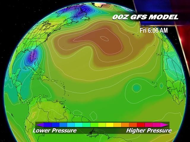

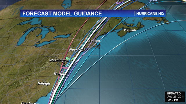
GFS en EMCWF laten Irene aan de oostkant van Florida verder richting het noorden trekken (langs de oostkust)
[ Bericht 1% gewijzigd door #ANONIEM op 21-08-2011 18:29:55 ]
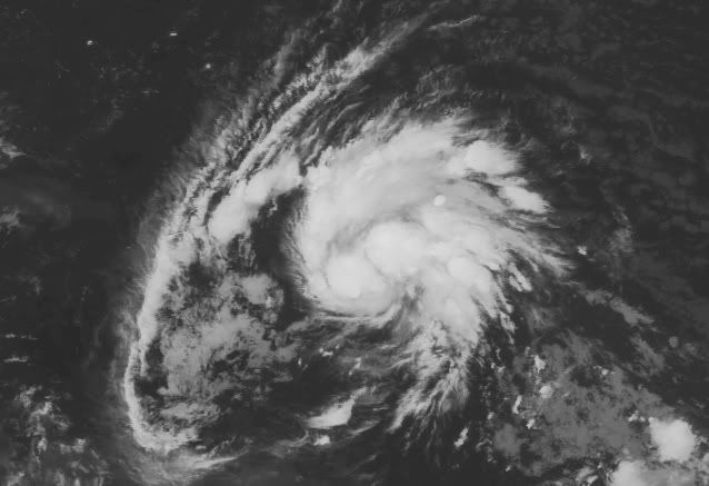
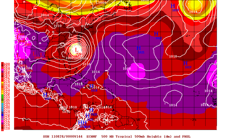
Cat1 is vanaf 119 km/uurquote:Het Atlantisch-Caribische orkanenseizoen begint geleidelijk wat meer smoel te krijgen. Tijdens de afgelopen 24 uur trok de 8ste tropische storm van het seizoen, Harvey, met regen van betekenis via Belize Mexico binnen. Het systeem is inmiddels afgezwakt tot een tropische depressie maar ter hoogte van het Caribische eiland Antigua bevindt zich inmiddels ‘numero 9’: Irene. Deze tropische storm trekt de komende dagen onder meer over het eiland Hispaniola (Dominicaanse Republiek/Haïti) en kan, uitgroeiend tot een orkaan van de eerste klasse, later een bedreiging vormen voor de Amerikaanse staat Florida.
Irene wordt mogelijk de eerste orkaan van het seizoen (gemiddelde windsnelheden vanaf 188 119km/uur): de voorgangers(ters) stelden niet veel voor. Arlene openende rond de maandwisseling (juni/juli) het seizoen met zware regen in delen van Mexico. Ook Don (zuiden van Texas) en Emily (onder meer Hispaniola) veroorzaakten regen van betekenis maar Bret, Cindy, Franklin en Gert waren kortstondig actief op de Atlantische Oceaan en spraken absoluut niet tot de verbeelding.
Jan Visser
[ Bericht 1% gewijzigd door #ANONIEM op 21-08-2011 18:29:55 ]
http://www.cnn.com/2011/W(...)l.weather/index.htmlquote:Tropical Storm Irene hits Puerto Rico
(CNN) -- Tropical Storm Irene made landfall along the east coast of Puerto Rico early Monday, lashing the island with winds up to 71 mph, the National Hurricane Center in Miami reported.
The storm was moving west-northwest at 15 mph (24 kph) and is expected to move near or over the Dominican Republic Monday afternoon or evening, forecasters said. It is expected to weaken as it does.
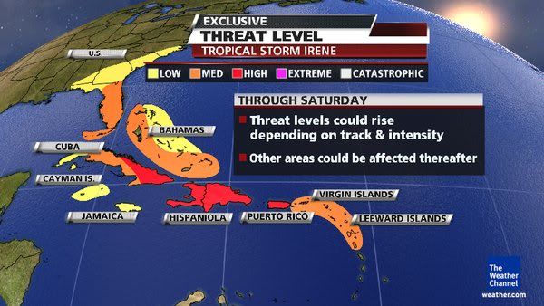
Rainfall amounts up 5 to 10 inches are expected across Puerto Rico, the Virgin Islands, the Dominican Republic, Haiti, the southeastern Bahamas and the Turks and Caicos Islands, the hurricane center said. Isolated maximum amounts of up to 20 inches are possible.
Hurricane warnings are in effect for Puerto Rico and the Dominican Republic and a hurricane watch is in effect for the central Bahamas and all of the U.S. Virgin Islands.
A tropical storm warning is in effect for the U.S. and British Virgin Islands, Haiti, southeastern Bahamas and the Turks and Caicos Islands.
The Christian aid group World Vision is prepositioning supplies and mobilizing its staff to fan out across camps in Haiti Monday, to help residents prepare for Irene.
"We are concerned that vulnerable families still living in temporary camps won't treat this storm as a serious threat, after Tropical Storm Emily didn't hit Port-au-Prince as predicted," warned World Vision's Meg Sattler in Port-au-Prince. "If flooding hits, people living in unsafe housing will be the worst affected. Heavy rain has the potential to worsen sanitation conditions in camps, which, with cholera still so prevalent in Haiti, is a major concern."
Meanwhile, the storm known as Harvey was near landfall in the southwestern Gulf of Mexcio. The system continued unleashing heavy rainfall early Monday.
At 2 a.m. ET Sunday, Harvey was almost onshore near Veracruz, Mexico, packing top winds of about 35 mph. The storm could dump another two to four inches of rain over southeastern Mexico, with some areas seeing as much as 10 inches, forecasters said.
Harvey struck the coast of Belize Sunday as a tropical storm, with top winds near 60 mph.


Orkaan Irene wordt zwaarder
Orkaan Irene zal de komende uren over de Bahama's heen gaan trekken en vervolgens zijn koers voort zetten richting de oostkust van de Verenigde Staten. Op het moment van schrijven is Orkaan Irene al categorie 3 op de Saffir-Simpson schaal, daarbij worden nu windsnelheden tot 195 kilometer per uur waargenomen. De verwachting is dat Irene de komende periode alleen maar in kracht toe zal gaan nemen en tegen de tijd zij de oostkust bereikt een heuse categorie 4 zal zijn!
De Saffir-Simpson schaal is een classificatie die in de meteorologie wordt gebruikt om de kracht van orkanen te bepalen. Deze schaal loopt op van categorie 1 t/m categorie 5. Als de windsnelheden meer dan 119km/h behalen dan mogen we spreken van een categorie 1 orkaan. Deze Safir-Simpson schaal is handig om te gebruiken, omdat men zich dan kan voorbereiden op de gevolgen die hen te wachten staat zodra de orkaan overtrekt.
Het is ook niet de eerste keer dat de Bahama's te maken krijgen met een orkaan. Voorgaande jaren hebben ze hier ook al mee te maken gehad, maar nu kunnen ze zich wel er beter op voorbereiden.
De komende dagen zal Irene in kracht toenemen, de verwachting is dat donderdag of vrijdag Irene kennis zal maken met de oostkust van de Verenigde Staten. Wel is het zo dat de berekeningen telkens weer veranderen. Daarom houden wij haar goed in de gaten, omdat zij nog van koers kan gaan veranderen.
Bron: Meteo-Info