WKN Weer, Klimaat en Natuurrampen
Lees alles over het onstuimige weer op onze planeet, volg orkanen en tornado's, zie hoe vulkanen uitbarsten en hoe Moeder Aarde beeft bij een aardbeving. Alles over de verwoestende kracht van onze planeet en tal van andere natuurverschijnselen.


Stevig huisje danquote:Op donderdag 8 september 2011 14:05 schreef aloa het volgende:
[..]
idd. Foto van Ike, waar nog 1 huis rechtovereind staat, de rest is plat.
[ afbeelding ]
<a href="https://www.youtube.com/channel/UCPueUwKfPaGH7v48LZlltkg" rel="nofollow" target="_blank">WSDokkum Youtube</a>

Die huisjes stonden op palen en deze stond waarschijnlijk hoger dan de rest. (hoog genoeg voor de stormsurge.)quote:
Toen had ik nog geen internet..quote:Op donderdag 8 september 2011 15:37 schreef Frutsel het volgende:
Andrew... dat kan ik me nog wel herinneren
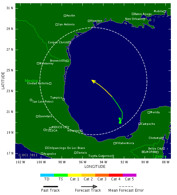
De koers van Nate is weer bijgesteld en gaat nu meer in de richting van Texas. Een aantal modellen gaan nu mee met GFS en een aantal laten Nate nog richting Mexico gaan.
[ Bericht 0% gewijzigd door #ANONIEM op 08-09-2011 19:48:33 ]
[ Bericht 0% gewijzigd door #ANONIEM op 08-09-2011 19:48:33 ]
Tropical Storm Nate
Tropical Storm Nate formed in the southern Gulf of Mexico yesterday afternoon after the Hurricane Hunters found a well-defined surface circulation and 45 mph surface winds. Nate is the 14th named storm this year, and comes three days before the climatological half-way point of the Atlantic hurricane season, September 10. A typical hurricane season has just 10 - 11 named storms, so we've already had 35% more than a whole season's worth of storms before reaching the season's half-way point. At this rate, 2011 will see 28 named storms, equaling the all-time record set in 2005. Nate's formation date of September 7 puts 2011 in 2nd place for earliest date of arrival of the season's 14th storm. Only 2005 had an earlier formation date of the season's 14th named storm (September 6, when Hurricane Nate got named.) Third place is now held jointly by 1936 and 1933, which got their 14th storm of the season on September 10.
Latest visible satellite loops show that Nate's low-level center is exposed to view, due to northeasterly upper-level winds that are creating a moderate 10 knots of wind shear. This shear is keeping all of Nate's heavy thunderstorms pushed to the south side of the center. Sustained winds at Buoy 42055, about 100 miles to the northwest of the suspected center of Nate, were north at 31 mph at 6:50 am CDT this morning. We haven't had a hurricane hunter aircraft in the storm since yesterday afternoon, and the next plane is due to arrive near 2 pm this afternoon. Water vapor satellite loops show that here is a large area of very dry air from Texas to the north of Nate, and this dry air is probably interfering with the storm's development.
Up until last night's 8 pm EDT runs of the computer models, the models were in general agreement that Nate would meander in the Bay of Campeche for several days, until a ridge of high pressure built in to the north of the storm, forcing it westwards to a landfall in Mexico. However, the latest 2 am EDT run by the GFS model predicts that Nate may gain enough latitude to escape being forced westwards by the ridge, and instead move northwards to make a landfall along the U.S. Gulf Coast. The GFDL, which uses the GFS for its initial conditions, is also on board with this idea, as is the HWRF model, to a lesser degree. The 2 am EDT run of the NOGAPS model did not go along with this idea, though. We will have to wait until the NOAA jet makes its first mission to sample the steering currents in the Gulf of Mexico to get a better idea on how probable this northern path might be; their first flight will be tonight, and the data will make it into the 8 pm models runs that will be available first thing Friday morning. As far as intensity goes, the very dry air to Nate's north should begin being less of a problem for it by Friday, when the upper level winds shift more to blow from the southeast, and the shear drops to the low range, 5 - 10 knots. Since the storm is moving very slowly, it will upwell cooler waters from the depths that will slow intensification, though. The earliest Nate would become a hurricane is probably on Saturday.
Wunderground
[ Bericht 0% gewijzigd door #ANONIEM op 08-09-2011 20:18:38 ]
Maria volgt ongeveer hetzelfde pad als Irene. Tropische storm waarschuwing voor de bovenwindse eilanden. Het is de vraag wat de koers gaat worden na de Bahama's. GFS laat haar nog wel in kracht toenemen en uiteindelijk voor de oostkust afbuigen. Maar dat is nog lang niet zeker.

Wow... Nate is snel aan kracht toegenomen en is al bijna een cat 1 orkaan.
Volgens de verwachting gaat hij nu draaien en bijna recht omhoog richting de VS als een cat. 2
Volgens de verwachting gaat hij nu draaien en bijna recht omhoog richting de VS als een cat. 2
Idem..... Discovery kan er programma's mee vullen.quote:
Andrew... dat kan ik me nog wel herinneren
Wilma was prachtig om te volgen..... die was bijna zo groot als de golf zelf (overdreven).
"I would like to thank everyone for all the kind wishes on a speedy recovery for me. I am doing better this afternoon but I still have at least another day I have to spend in the hospital"quote:
hoop dat crazymother.tv nog wat gaat doen, wat een hoop actieve stormen ineens, wow
Hij had iets van een longontsteking opgelopen
<hr>
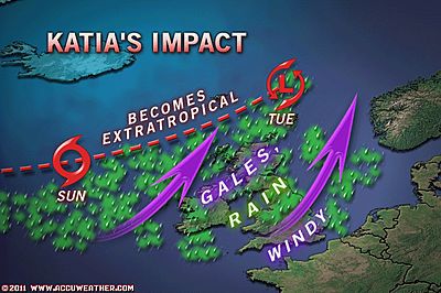
Katia to Target Northwest Europe After Passing Canada
The U.K. and parts of Northwest Europe will feel the wrath of Katia by the start of next week.
Hurricane Katia will sweep across the North Atlantic Ocean Saturday, then clip the British Archipelago as it becomes a powerful extratropical storm Sunday to Tuesday.
Katia's gales and slashing rain will overspread Ireland and Scotland late Sunday and early Monday, persisting through Tuesday. Hurricane gusts will be possible, with the greatest threat along northern shores and over hills.
Strong winds with gale-force gusts will also whip England and Wales, where some rain will also fall.
On the European mainland, northernmost France through the Netherlands and Denmark will be windswept with some rain owing to Katia. But western Norway will fare worse, having gales and drenching rain early next week.
Prior to crossing the cold waters of the North Atlantic, Katia will pass well to the east of Nova Scotia and Newfoundland, Canada during Friday.
While rough seas will affect these areas the strongest winds and rainfall should stay to the east, thanks to a strong jet stream from the west over head.
Accuweather
The U.K. and parts of Northwest Europe will feel the wrath of Katia by the start of next week.
Hurricane Katia will sweep across the North Atlantic Ocean Saturday, then clip the British Archipelago as it becomes a powerful extratropical storm Sunday to Tuesday.
Katia's gales and slashing rain will overspread Ireland and Scotland late Sunday and early Monday, persisting through Tuesday. Hurricane gusts will be possible, with the greatest threat along northern shores and over hills.
Strong winds with gale-force gusts will also whip England and Wales, where some rain will also fall.
On the European mainland, northernmost France through the Netherlands and Denmark will be windswept with some rain owing to Katia. But western Norway will fare worse, having gales and drenching rain early next week.
Prior to crossing the cold waters of the North Atlantic, Katia will pass well to the east of Nova Scotia and Newfoundland, Canada during Friday.

While rough seas will affect these areas the strongest winds and rainfall should stay to the east, thanks to a strong jet stream from the west over head.
Accuweather
Maria is wel een groot systeem. Gaat later nog activeren naar orkaan.
Puerto Rico, Dominicaanse Republiek (Haiti?) en de bovenwindse eilanden gaan flink wat neerslag krijgen.
Puerto Rico, Dominicaanse Republiek (Haiti?) en de bovenwindse eilanden gaan flink wat neerslag krijgen.
Hehe die gaat recht over mijn huisquote:
En daar is Nate ook alweer:
[ afbeelding ]
Ceterum censeo Turciam delendam esse.
Katia is nog erg goed zichtbaar vind ik, terwijl ze al zover noordelijk ligtquote:
Maria is wel een groot systeem. Gaat later nog activeren naar orkaan.
Puerto Rico, Dominicaanse Republiek (Haiti?) en de bovenwindse eilanden gaan flink wat neerslag krijgen.
[ afbeelding ]
Katia is onderweg naar Europa. Maandag gaan vooral Schotland en Ierland een flinke klap krijgen van minimaal een windkracht 10. Ook Nederland gaat veel wind krijgen, maar dat zal waarschijnlijk niet meer dan kracht 8 worden.quote:
[..]
Katia is nog erg goed zichtbaar vind ik, terwijl ze al zover noordelijk ligt

Bagger, ik wil windkracht 12!quote:
[..]
Katia is onderweg naar Europa. Maandag gaan vooral Schotland en Ierland een flinke klap krijgen van minimaal een windkracht 10. Ook Nederland gaat veel wind krijgen, maar dat zal waarschijnlijk niet meer dan kracht 8 worden.
|| FOK!Stok || tatatatatataatatatattaaaaapiediedieuwtididipieuwpidibididi She said I'll throw myself away pididididum They're just photos after all! || Den Helder || Winnaar VBL Wijndal-award 2020: beste AZ-user! || Mijn concertstatistieken ||
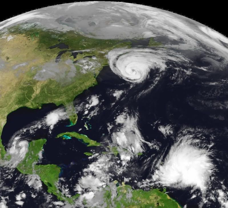
http://www.wunderground.c(...)t.html?entrynum=1925quote:Hurricane Katia
Hurricane Katia brushed by Newfoundland, Canada this morning, and is now racing east-northeast at 52 mph into the open Atlantic. With water temperatures 19°C (66°F) underneath it, Katia has lost its tropical characteristics, and has transitioned to a powerful extratropical storm. Extratropical Storm Katia will continue east-northeastward towards Europe, and on Monday, the storm will pass very close to northern British Isles. The offshore waters of Northern Ireland and Western Scotland can expect storm-force winds of 50 - 60 mph on Monday as Katia roars past to the north. The storm will bring 2 - 4 inches of rain to the coast, and likely cause significant tree damage and power failures.
Vermisten olieplatform teruggevonden
In de Golf van Mexico zijn drie dagen nadat ze in een reddingsboot van hun olieplatform waren gevlucht, zeven van de tien vermiste medewerkers levend teruggevonden. Van twee anderen zijn de lichamen gevonden. Eén persoon blijft nog vermist.
Donderdagmiddag raasde tropische storm Nate langs hun platform, dat daardoor beschadigd raakte. De mannen vroegen om hulp en verlieten het platform in hun reddingsboot.
Helikopters
Het hele weekend werd naar ze gezocht met helikopters, boten en vliegtuigen. Zondagmiddag werden ze ontdekt en per helikopter naar het ziekenhuis overgebracht. Of de twee overleden medewerkers ook in de reddingsboot zaten, is niet bekendgemaakt.
Naar de vermiste medewerker wordt nog steeds gezocht.
nos
Orkaan Katia bereikt Schotse kust
Orkaan Katia is aangekomen in Schotland. De Schotten krijgen te maken met de staart van de orkaan. Al kunnen de restanten van zo'n orkaan nog erg hevig zijn. Dat bewijzen de eerste beelden van Katia die inbeukt op de kust.
Met windsnelheden tot 110 kilometer per uur is Katia nog sterk genoeg om bomen te ontwortelen. Er gelden waarschuwingen voor Schotland, Noord-Ierland en het noorden van Engeland. Daarnaast brengt de storm ook veel regen mee die voor overstromingen kan zorgen. In de Verenigde Staten was Katia goed voor golven die tot zeven meter hoog waren.
Stormen als Katia zijn niet abnormaal voor het Verenigd Koninkrijk. In deze tijd van het jaar wordt de regio wel vaker getroffen door het uiteinde van een tropische storm. (gb)
hln
Flinke golven

Orkaan Katia is aangekomen in Schotland. De Schotten krijgen te maken met de staart van de orkaan. Al kunnen de restanten van zo'n orkaan nog erg hevig zijn. Dat bewijzen de eerste beelden van Katia die inbeukt op de kust.

Met windsnelheden tot 110 kilometer per uur is Katia nog sterk genoeg om bomen te ontwortelen. Er gelden waarschuwingen voor Schotland, Noord-Ierland en het noorden van Engeland. Daarnaast brengt de storm ook veel regen mee die voor overstromingen kan zorgen. In de Verenigde Staten was Katia goed voor golven die tot zeven meter hoog waren.
Stormen als Katia zijn niet abnormaal voor het Verenigd Koninkrijk. In deze tijd van het jaar wordt de regio wel vaker getroffen door het uiteinde van een tropische storm. (gb)

hln
Flinke golven


