WKN Weer, Klimaat en Natuurrampen
Lees alles over het onstuimige weer op onze planeet, volg orkanen en tornado's, zie hoe vulkanen uitbarsten en hoe Moeder Aarde beeft bij een aardbeving. Alles over de verwoestende kracht van onze planeet en tal van andere natuurverschijnselen.


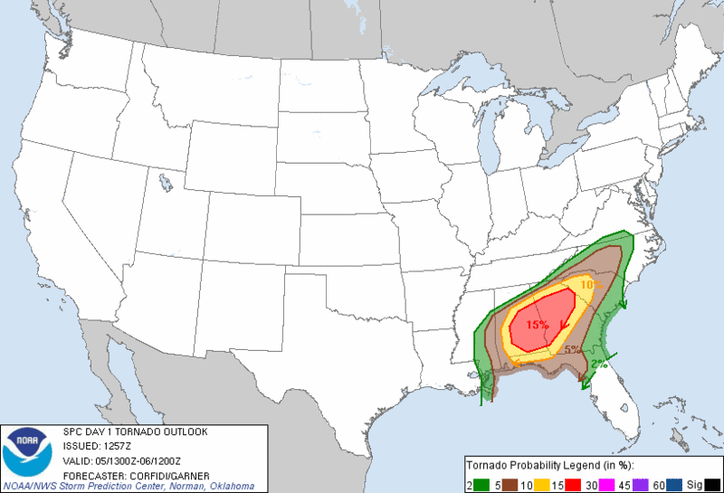
Moderate risk.
[ Bericht 42% gewijzigd door #ANONIEM op 05-09-2011 16:48:10 ]
Nieuw orkaangevaar (Lee) voor de V.S.?quote:LATER TODAY...AND CONTINUING TNGT THROUGH EARLY TUE...EMBEDDED
ROTATING STRUCTURES/LEWPS MAY POSE A THREAT FOR MORE ISOLD TORNADOES
AND LOCALLY DMGG WIND GUSTS ALONG THE AFOREMENTIONED FRONTOGENETIC
ZONE AS THAT FEATURE DEVELOPS ENEWD FROM NRN GA INTO WRN AND CNTRL
PARTS OF THE CAROLINAS.
[ Bericht 42% gewijzigd door #ANONIEM op 05-09-2011 16:48:10 ]

Accuweatherquote:A tornado formed sometime around 3:30 p.m. EDT, just west of Ocean City, Md., on Thursday.
The tornado moved partly over Isle of Wight Bay, before heading out to sea. It moved very quickly and had already reached the ocean by 5 p.m. EDT.
A strong cold front moving through Maryland fired up a line of thunderstorms that could have produced tornados without warning, according to WBAL-TV.
The tornado went across the island on 75th Street as it moved from the bay to the ocean.
Reports from across the area have stated the tornado left "considerable damage" in its path. A condominium on 75th street hardest hit, with roof and window damage.
"This tornado moved very quickly eastward," said AccuWeather.com Expert Meteorologist Frank Strait. "It formed very close to Ocean Pines, Maryland."
When a tornado moves over a body of water it becomes a "waterspout." While damage reports have been made, Strait says this tornado wasn't all that strong.
"The circulation was obviously very small and not supercellular in nature," added Strait.

Accuweatherquote:While filming one tornado near Wakita, Okla., on Saturday evening, Youtube user JordanHenion captured a second tornado forming.
The first tornado has a well-defined funnel that can be seen on the left-hand side of the image for most of the video. The SPC storm report (below) for Sept. 17, 2011 shows the report for this tornado, which was located 10 miles west of Milford, Okla., about one mile west of Redhill Road along State Highway 11.
If you look to the right of the first tornado, you can start to see a horizontal rotation form as the video continues (funnel clouds and tornadoes are visible due to water vapor). By the end of the video the roll becomes better defined and is forced into a vertical position by a strong updraft, touching down as a rope tornado.
Fortunately, it appears that these tornadoes were over an open field and no damage was reported with them.
A storm system was sitting over southeastern Colorado on Saturday evening acting as a trigger for thunderstorms. A violent clash of humid air surging in from the Gulf of Mexico and dry air flowing in from the Desert Southwest set the stage for violent thunderstorms across western Oklahoma and northern Texas.

Aflevering 1 Stormchasers 2011
http://networkedblogs.com/nAvYW
Aflevering 2 Stormchasers 2011
http://microstation-trend(...)son-5-episode-2.html
Uiteraard kan ik niks aan de spam doen die op de sites te vinden is...
http://networkedblogs.com/nAvYW
Aflevering 2 Stormchasers 2011
http://microstation-trend(...)son-5-episode-2.html
Uiteraard kan ik niks aan de spam doen die op de sites te vinden is...
Nog 4/5 maanden wachten voor een nieuw seizoenquote:Op dinsdag 11 oktober 2011 14:42 schreef _Flea_ het volgende:
Afgelopen week seizoen 4 gekeken. Man, wat een bazenserie! En wat een natuurgeweld.
Seizoen 5 is net begonnenquote:
[..]
Nog 4/5 maanden wachten voor een nieuw seizoen
Hmmz daar moet ik vanavond maar even naar kijken 
<a href="https://www.youtube.com/channel/UCPueUwKfPaGH7v48LZlltkg" rel="nofollow" target="_blank">WSDokkum Youtube</a>

You better lose yourself in the music
The moment, you own it, you better never let it go
The moment, you own it, you better never let it go
29 september 2011 San Antonio, Texas, US
Het begon opeens te betrekken en ik moest ff een foto maken van de lucht
Het begon opeens te betrekken en ik moest ff een foto maken van de lucht

<hr>
Aflevering 5 Stormchasers 2011
Aflevering 6 Stormchasers 2011
http://eztvstream.com/sto(...)-6-too-close-to-home

Aflevering 6 Stormchasers 2011
http://eztvstream.com/sto(...)-6-too-close-to-home
Heftig.quote:
Aflevering 5 Stormchasers 2011
Aflevering 6 Stormchasers 2011
http://eztvstream.com/sto(...)-6-too-close-to-home
Vooral het einde met de tornado van Joplin.
vanavond aflevering 6 van stormchasers maar eens downloaden... gisteren was ie nog niet beschikbaar helaas.
* I intend to live forever, so far so good! *
Klopt.. ik kijk ze vaak in één ruk uit... was al benieuwd wat oa de Joplin tornado zou brengen voor deze geweldige serie. Zoveel vernietiging en doden daarquote:
vanavond aflevering 6 van stormchasers maar eens downloaden... gisteren was ie nog niet beschikbaar helaas.

quote:Outbreak severe weather possible next week
As storm systems, jet stream energy and temperature contrast converge over the middle of the nation next week, an outbreak of severe weather is possible from Texas and the southern Plains to the Southeast and the Ohio Valley.
The weather pattern next week will favor building warmth over much of the eastern half of the nation with a flow of humid air developing off the Gulf of Mexico over the South Central states.
Meanwhile, a potent storm system is forecast to travel from Texas to the Great Lakes during the middle of the week.
If the currently growing dip in the jet stream in the West were to lunge toward the Mississippi Valley around the same time, we could be looking at damaging thunderstorms including tornadoes in part of an area hit hard by violent weather during the spring.
It is too early to give much detail on the situation. However, it appears the size of the threat area for severe thunderstorms at this time would be rather large and stretch from central Texas to south-central Kansas, eastward to the Florida Panhandle to the Ohio Valley.