WKN Weer, Klimaat en Natuurrampen
Lees alles over het onstuimige weer op onze planeet, volg orkanen en tornado's, zie hoe vulkanen uitbarsten en hoe Moeder Aarde beeft bij een aardbeving. Alles over de verwoestende kracht van onze planeet en tal van andere natuurverschijnselen.


Gaat lekker in de vulkanen wereld.
2012 komt nu wel heel dichtbij hehe
Neh we moeten het maar lekker in de gaten houden, vulkanen zijn leuk om te zien maar de bijwerkingen daarvan zijn een heel stuk minder
2012 komt nu wel heel dichtbij hehe
Neh we moeten het maar lekker in de gaten houden, vulkanen zijn leuk om te zien maar de bijwerkingen daarvan zijn een heel stuk minder
<a href="https://www.youtube.com/channel/UCPueUwKfPaGH7v48LZlltkg" rel="nofollow" target="_blank">WSDokkum Youtube</a>
http://www.ct.ingv.it/index.php?option=com_wrapper&view=wrapper&Itemid=201
Tremoren Etna. Explanation please??
Tremoren Etna. Explanation please??
Crazy as Always...met vleugels natuurlijk..;-0
Ach, Etna is altijd bezig. Niet echt een spannende vulkaan.quote:Op woensdag 28 september 2011 18:34 schreef zenkelly het volgende:
http://www.ct.ingv.it/index.php?option=com_wrapper&view=wrapper&Itemid=201
Tremoren Etna. Explanation please??
Op El Hierro staat er ook 1 op ploffen.
If it has a grass wicket, play cricket! (Nee, dit slaat niet op het spelletje!)
Lullo scrotum ejaculatio est.
Hattrick: Ladderzatsquad (208243)
Lullo scrotum ejaculatio est.
Hattrick: Ladderzatsquad (208243)
Zie Vulkaanuitbarsting op Canarische Eilanden op komst?quote:
Op El Hierro staat er ook 1 op ploffen.
bzzzzzzz
Etna heeft ook een eigen topic 
Uitbarsting Etna
Maar het is jammer dat zaken als Ali B en Patricia P belangrijker zijn op andere delen van Fok dan dat nieuwsberichten uit dit deel eens wat meer aandacht krijgen. Maar ja, je went er aan.
[ Bericht 11% gewijzigd door Frutsel op 29-09-2011 10:05:37 ]
Uitbarsting Etna
Maar het is jammer dat zaken als Ali B en Patricia P belangrijker zijn op andere delen van Fok dan dat nieuwsberichten uit dit deel eens wat meer aandacht krijgen. Maar ja, je went er aan.
[ Bericht 11% gewijzigd door Frutsel op 29-09-2011 10:05:37 ]
quote:Vulkaanuitbarsting Tenerife helpt aardverschuivingen te begrijpen
AMSTERDAM - De ontdekking van een grote vulkaanuitbarsting op Tenerife van 733.000 jaar geleden werpt nieuw licht op aardverschuivingen. Zo is men in de toekomst mogelijk beter voorbereid op de gevolgen van dit soort grote catastrofes.
Vulkanologen van de Universiteit van Leicester ontdekten op het Canarische eiland Tenerife een aardverschuiving ten gevolge van een grote vulkaanuitbarsting waarbij een deel van de zijkant van de vulkaan de zee in verdween.
Ze publiceerden hun bevindingen in de oktober-editie van het tijdschrift Geology.
Bijzonder
Het is bijzonder dat niet vrijwel de hele aardverschuiving door de uitbarsting de zee in verdwenen is. "Het is een van de best bewaarde en toegankelijke voorbeelden van zo’n ontzagwekkend fenomeen, omdat het puin van zulke aardverschuivingen zich meestal over de oceaanbodem verspreid en daardoor ontoegankelijk voor verdere studie", verklaart Dr. Branney, een van de onderzoekers.
Het achtergebleven puin en gruis op Tenerife bevat onder andere blokken van snel afgekoeld stollingsgesteente. Radioactieve mineralen in de gestolde lava maakten het voor de onderzoekers makkelijk om zeer precies de datum van de uitbarsting te bepalen.
Klimaatverandering
Klimaatverandering wordt vaak aangewezen als reden voor aardverschuivingen op eilanden in de oceaan. Dat was nu niet het geval. Een groeiende koepel van hete lava duwde van binnenuit de zijkant van de vulkaan naar buiten toe.
Zulke gebeurtenissen zijn niet ongewoon, maar komen zeer onregelmatig voor. Ze begrijpen is daarom van belang omdat de effecten duizenden kilometers verderop grote problemen kunnen veroorzaken.
quote:Zes Indonesische vulkanen op verscherpt toezicht
JAKARTA - Hoewel inmiddels zes vulkanen onder scherp toezicht staan vanwege hun verhoogde activiteit, heeft het Nationaal Agentschap Rampen BNPB laten weten dat op dit moment er geen noodzaak is tot het evacueren van inwoners.
Een woordvoerder van BNPN, Sutopo Purwo Nugroho zei zondag dat er zes vulkanen op een verhoogde alarm-status staan op dit moment; de Tambora vulkaan in West Nusa Tenggara, de Anak Ranaka in Oost Nusa Tenggara, de Papandayan in West Java, de Karangetang en Lokon in Noord Sulawesi en de Anak Krakatau in de Sunda Straat.
"Deze vulkanen staan op dit moment op alarm-status drie op een schaal van vier. Dit betekent dat ze vulkanisch zo actief zijn dat dit zou kunnen leiden tot een uitbarsting of een ramp," aldus Nugroho via SMS aan de Jakarta Post.
Nugroho voegde toe dat de Anak Krakatau vulkaan op dit moment zo'n 5.000 trillingen per dag liet registreren. Er is een twee kilometer grote zone rond de top van de vulkaan als onveilig bestempeld. De vulkanen worden de klok rond geobserveerd door instrumenten en personen.

quote:Swarm of earthquakes around Mt.Rainier
SEATTLE -- It may not amount to much, like so many times before, but seismologists are paying close attention to a recent swarm of earthquakes on Mount Rainier.
Data from the Pacific Northwest Seismic Network show at least seven earthquakes in the last two weeks around the mountain.
One of the strongest was last Friday, when a 3.4 magnitude quake struck in the afternoon near Ashford. Earlier that day, a 2.9 magnitude quake shook beneath Mount Rainier.
Thousands of tiny quakes preceed the erruption of Mt. St. Helens seven years ago as magma was being pushed upward from deep below. As they were then, scientists say these quakes are also shallow, but not necessarily a warning sign of anything immediate.
"It helps seeing these types of events over, in my case, decades," said University of Washington seismologist Steve Malone.
Seismologists are also watching Eastern Washington, where there have been at least four earthquakes in the last few days around a small area on the Columbia River just north of Richland.
Coincidentally, a 3.4 magnitude quake struck that area the same day as the Ashford quake near Mount Rainier. However, scientists say the two swarms are not connected.
"We just have to pay attention," said Malone. "Just keep watching it."
Valt allemaal mee 
Mt. Rainier Earthquakes: When the “News” isn’t News
http://www.wired.com/wire(...)-the-news-isnt-news/
Mocht hij nog niet genoemd zijn dit is een erg interessante blog:
http://www.wired.com/wiredscience/eruptions
Mt. Rainier Earthquakes: When the “News” isn’t News
http://www.wired.com/wire(...)-the-news-isnt-news/
Mocht hij nog niet genoemd zijn dit is een erg interessante blog:
http://www.wired.com/wiredscience/eruptions

Had het net ook gelezen inderdaad.
Maar goed, daar is dit 'centrale' topic ook voor... alles wat gemeld wordt over vulkanen, kan hier in...
Als het echt slim wordt, krijgt Rainier wel een eigen topic
Maar goed, daar is dit 'centrale' topic ook voor... alles wat gemeld wordt over vulkanen, kan hier in...
Als het echt slim wordt, krijgt Rainier wel een eigen topic

quote:Earthquakeswarm at Mauna Kea Hawaii
After yesterday’s post on the “swarm” at Rainier (which apparently rubbed a lot of people the wrong way), I was hesitant to post on the news coming from Mauna Kea right away, but if you’re looking for a real swarm of earthquakes at a volcano, look no further (see below). Since early yesterday (Hawaii time), the volcano has experienced at least 38 earthquakes, some as large at M4.5, all centered NW of the main summit of Mauna Kea, all at depths between 14-19 km (see below), all below the crust under the Big Island. This is what a suspicious swarm looks like, where we have a strong focus of seismicity at depth under an active volcano – the question now is how persistent will this swarm be. More likely than not, these earthquakes will lead to nothing – and HVO says these earthquakes are “most likely caused by structural adjustments within the Earth’s crust due to the heavy load of Mauna Kea”. Remember, Mauna Kea is a huge point weight on the crust and upper mantle below Hawai’i, towering over 4,200 m / 13,800 feet above sea level, thus about 9,000-10,000 m above the seafloor, so a lot of stress can accumulate from the mass of the volcano. This means earthquakes are likely common as that stress builds.
Remember, Kilauea and Mauna Loa are not the only active volcanoes on the Big Island of Hawai’i. Haulalai last erupted as recently as 1801, while Mauna Kea, the 2nd oldest shield volcano on the island last erupted only ~4,470 years ago. For argument’s sake (not that this swarm looks to be leading to any eruption), Mauna Kea is located on the back side of the active plume head for Hawai’i – so we think the “hotspot” is located under Kilauea. However, even after the plate has passed over the hotspot, volcanism can continue for some time – the “post-shield” phase of the volcano. In the very small likelihood that these earthquakes under Mauna Kea are leading to a new eruption, it is likely to be a small eruption of alkalic basalt (as opposed to the tholeiitic basalt at Kilauea – these terms just refer to the extent of melting that occurred to form the magma). Interestingly, most of the recent activity at Mauna Kea has been on the NE or S flanks, not the NW. Mauna Kea has felt swarms before, so this by no means something is in the works. However, considering the astronomical infrasructure at the summit of Mauna Kea, it needs to be watched closely. Even this increased seismicity can’t be good for highly sophisticated telescopes such as those on Mauna Kea.

quote:Rapidly Inflating Volcano Creates Growing Mystery
Should anyone ever decide to make a show called "CSI: Geology," a group of scientists studying a mysterious and rapidly inflating South American volcano have got the perfect storyline.
Researchers from several universities are essentially working as geological detectives, using a suite of tools to piece together the restive peak's past in order to understand what it is doing now, and better diagnose what may lie ahead.
It's a mystery they've yet to solve.
Uturuncu is a nearly 20,000-foot-high (6,000 meters) volcano in southwest Bolivia. Scientists recently discovered the volcano is inflating with astonishing speed.
"I call this 'volcano forensics,' because we're using so many different techniques to understand this phenomenon," said Oregon State University professor Shan de Silva, a volcanologist on the research team.
Researchers realized about five years ago that the area below and around Uturuncu is steadily rising — blowing up like a giant balloon under a wide disc of land some 43 miles (70 kilometers) across. Satellite data revealed the region was inflating by 1 to 2 centimeters (less than an inch) per year and had been doing so for at least 20 years, when satellite observations began.
"It's one of the fastest uplifting volcanic areas on Earth," de Silva told OurAmazingPlanet."What we're trying to do is understand why there is this rapid inflation, and from there we'll try to understand what it's going to lead to."
The peak is perched like a party hat at the center of the inflating area. "It's very circular. It's like a big bull's-eye," said Jonathan Perkins, a graduate student at the University of California, Santa Cruz, who recently presented work on the mountain at this year's Geological Society of America meeting in Minneapolis.
Scientists figured out from the inflation rate that the pocket of magma beneath the volcano was growing by about 27 cubic feet (1 cubic meter) per second.
"That's about 10 times faster than the standard rate of magma chamber growth you see for large volcanic systems," Perkins told OurAmazingPlanet.
However, no need to flee just yet, the scientists said.
"It's not a volcano that we think is going to erupt at any moment, but it certainly is interesting, because the area was thought to be essentially dead," de Silva said.
Uber-Uturuncu?
Uturuncu is surrounded by one of the most dense concentrations of supervolcanoes on the planet, all of which fell silent some 1 million years ago.
Supervolcanoes get their name because they erupt with such power that they typically spew out 1,000 times more material, in sheer volume, than a volcano like Mount St. Helens. Modern human civilization has never witnessed such an event. The planet's most recent supervolcanic eruption happened about 74,000 years ago in Indonesia.
"These eruptions are thought to have not only a local and regional impact, but potentially a global impact," de Silva said.
Uturuncu itself is in the same class as Mount St. Helens in Washington state, but its aggressive rise could indicate that a new supervolcano is on the way. Or not.
De Silva said it appears that local volcanoes hoard magma for about 300,000 years before they blow — and Uturuncu last erupted about 300,000 years ago.
"So that's why it's important to know how long this has been going on," he said.
To find an answer, scientists needed data that stretch back thousands of years — but they had only 20 years of satellite data.
Volcano rap sheet
"So that's where we come in as geomorphologists — to look for clues in the landscape to learn about the long-term topographic evolution of the volcano," Perkins said.
Perkins and colleagues used ancient lakes, now largely dry, along the volcano's flanks to hunt for signs of rising action.
"Lakes are great, because waves from lakes will carve shorelines into bedrock, which make lines," Perkins said.
If the angle of those lines shifted over thousands of years — if the summit of the mountain rose, it would gradually lift one side of the lake — it would indicate the peak had been rising for quite some time, or at least provide a better idea of when the movement began.
The local conditions, largely untouched by erosion or the reach of lush plant and animal life, lend themselves to geological detective work, Perkins noted.
"It's a really sparse, otherworldly landscape," Perkins said. "Everything is so well preserved. There's no biology to get in the way of your observations."
Perkins said that surveys conducted on the lakes last autumn didn't indicate long-term inflation. However, tilting lakes are only one indicator of volcano growth, he said.
De Silva said the geological detective team is working to combine data from a number of sources — seismic data, GPS data, even minute variations in gravity — to pin down when and why the mountain awoke from its 300,000-year-long slumber, and better predict its next big move.
On the brink: Tremors increase at Anak Krakatau to 5,000 a day
Posted on October 22, 2011 by The Extinction Protocol
October 22, 2011 – SUMATRA, Indonesia –Several earthquakes have struck near south Sumatra of the 5.0 and 5.1 magnitude range today- making a tense situation on the volcanically-dotted archipelago potentially even more volatile. The Anak Krakatau volcano is showing signs of increased seismic activity. Authorities fear the volcano is building towards an eruption that could dwarf the one which occurred in 2007. Indonesia’s Volcanology and Geological Disasters Mitigation Center reported the numbers of seismic tremors now registering from the volcano have exceeded 5,000 a day. There are also reports of a gaseous mist which has seeped from the volcano and have enshrouded it in a yellowish haze- something that has never been observed at the volcano before. Anak Krakatau was placed on orange (level 3) status alert on September 30, 2011. –The Extinction Protocol
http://theextinctionproto(...)katau-to-5000-a-day/
Thx! Krakatau heeft trouwens ook een eigen topicquote:
On the brink: Tremors increase at Anak Krakatau to 5,000 a day
Posted on October 22, 2011 by The Extinction Protocol
October 22, 2011 – SUMATRA, Indonesia –Several earthquakes have struck near south Sumatra of the 5.0 and 5.1 magnitude range today- making a tense situation on the volcanically-dotted archipelago potentially even more volatile. The Anak Krakatau volcano is showing signs of increased seismic activity. Authorities fear the volcano is building towards an eruption that could dwarf the one which occurred in 2007. Indonesia’s Volcanology and Geological Disasters Mitigation Center reported the numbers of seismic tremors now registering from the volcano have exceeded 5,000 a day. There are also reports of a gaseous mist which has seeped from the volcano and have enshrouded it in a yellowish haze- something that has never been observed at the volcano before. Anak Krakatau was placed on orange (level 3) status alert on September 30, 2011. –The Extinction Protocol
http://theextinctionproto(...)katau-to-5000-a-day/
Hudson Volcano active after 20 years
The National Service of Geology and Mining (SERNAGEOMIN) – Volcano Observatory of the Southern Andes (OVDAS), announced that from the early hours of last night there has been increased seismic activity related to the Hudson volcano. At 19:08 local time, an earthquake Volcano-tectonic (VT), magnitude (ML) equal to 4.6 located 7 km to the NW edge of the caldera, at a depth of 19 km, which was followed by the occurrence of a seismic swarm starting at 21:49 hrs, includes more than 100 seismic events recorded until the time of this report, whose depths range from 15 to 25 km. It notes that 15 events recorded magnitudes (ML) greater than 3.0 and three (3) of these magnitudes (ML) greater than 4.0, all characterized by having more to do with broken rock (VT) at 00: local 20 hours today, Wednesday, October 26, an earthquake associated with fluid movement and characterized by very low frequency (long period – VLP), located in the same area at a depth of 15 km, with a magnitude (ML) equal to 4.3. The seismic swarm continues at the time of issuance of this report with less intensity. The preceding activity indicates that the volcanic system has experienced changes in their dynamics, possibly associated magmatic activity at depth, which in the future the system can lead to imbalance.
Pre-eruption: The Chilean authorities decided to raise the alert level to red and preventive evacuations in an area of 40 kilometers around Mount Hudson. The column emission from the eruption reached 1 km in height. The information was confirmed this afternoon from Vice President Rodrigo Hinzpeter Onemi, from where he said he “cannot rule out an eruption,” so it was decided to evacuate people living in that radius.” An over-flight of the area showed a column of smoke and gases out of the cone of the Hudson. In addition, there were some signs of an avalanche in the vicinity. –Diarioandino
Hudson’s explosive history: “Large eruptions around 4750 BCE and 1890 BCE are believed to have been of Volcanic Explosivity Index VEI 6; these are probably responsible for the large caldera. The 4750 BCE eruption may have wiped out many if not all groups of early man living in central Patagonia at that time, based on evidence from the Los Toldos archaeological site. Before 1970, little was known about the mountain. Minor eruptive activity began in 1970 and melted parts of the glacier, raising river water levels and leading to the identification of the caldera. In August-September 1971, a moderate eruption (VEI 3) located in the northwest area of the caldera sent ash into the air and caused lahars from the melting of a large portion of the glacier. The lahars killed five people; many more were evacuated. It’s last eruption in August to October 1991 was a large plinian eruption with a VEI of 5, that ejected 4.3 km3 bulk volume (2.7 cubic km of dense rock equivalent material). Parts of the glacier melted and ran down the mountain as mud flows. Due to the remoteness of the area, no humans were killed but hundreds of people were evacuated from the vicinity. Ash fell on Chile and Argentina as well as in the South Atlantic Ocean and on the Falkland Islands. In addition to the ash, a large amount of sulfur dioxide gas and aerosols were ejected in the eruption. These contributed to those already in the atmosphere from the even larger Mount Pinatubo eruption earlier in the year and helped cause a worldwide cooling effect over the following years. Ozone was also depleted, with the Antarctic ozone hole growing to its largest levels ever recorded in 1992 and 1993.

The National Service of Geology and Mining (SERNAGEOMIN) – Volcano Observatory of the Southern Andes (OVDAS), announced that from the early hours of last night there has been increased seismic activity related to the Hudson volcano. At 19:08 local time, an earthquake Volcano-tectonic (VT), magnitude (ML) equal to 4.6 located 7 km to the NW edge of the caldera, at a depth of 19 km, which was followed by the occurrence of a seismic swarm starting at 21:49 hrs, includes more than 100 seismic events recorded until the time of this report, whose depths range from 15 to 25 km. It notes that 15 events recorded magnitudes (ML) greater than 3.0 and three (3) of these magnitudes (ML) greater than 4.0, all characterized by having more to do with broken rock (VT) at 00: local 20 hours today, Wednesday, October 26, an earthquake associated with fluid movement and characterized by very low frequency (long period – VLP), located in the same area at a depth of 15 km, with a magnitude (ML) equal to 4.3. The seismic swarm continues at the time of issuance of this report with less intensity. The preceding activity indicates that the volcanic system has experienced changes in their dynamics, possibly associated magmatic activity at depth, which in the future the system can lead to imbalance.
Pre-eruption: The Chilean authorities decided to raise the alert level to red and preventive evacuations in an area of 40 kilometers around Mount Hudson. The column emission from the eruption reached 1 km in height. The information was confirmed this afternoon from Vice President Rodrigo Hinzpeter Onemi, from where he said he “cannot rule out an eruption,” so it was decided to evacuate people living in that radius.” An over-flight of the area showed a column of smoke and gases out of the cone of the Hudson. In addition, there were some signs of an avalanche in the vicinity. –Diarioandino

Hudson’s explosive history: “Large eruptions around 4750 BCE and 1890 BCE are believed to have been of Volcanic Explosivity Index VEI 6; these are probably responsible for the large caldera. The 4750 BCE eruption may have wiped out many if not all groups of early man living in central Patagonia at that time, based on evidence from the Los Toldos archaeological site. Before 1970, little was known about the mountain. Minor eruptive activity began in 1970 and melted parts of the glacier, raising river water levels and leading to the identification of the caldera. In August-September 1971, a moderate eruption (VEI 3) located in the northwest area of the caldera sent ash into the air and caused lahars from the melting of a large portion of the glacier. The lahars killed five people; many more were evacuated. It’s last eruption in August to October 1991 was a large plinian eruption with a VEI of 5, that ejected 4.3 km3 bulk volume (2.7 cubic km of dense rock equivalent material). Parts of the glacier melted and ran down the mountain as mud flows. Due to the remoteness of the area, no humans were killed but hundreds of people were evacuated from the vicinity. Ash fell on Chile and Argentina as well as in the South Atlantic Ocean and on the Falkland Islands. In addition to the ash, a large amount of sulfur dioxide gas and aerosols were ejected in the eruption. These contributed to those already in the atmosphere from the even larger Mount Pinatubo eruption earlier in the year and helped cause a worldwide cooling effect over the following years. Ozone was also depleted, with the Antarctic ozone hole growing to its largest levels ever recorded in 1992 and 1993.
quote:Nyamuragira volcano erupts
November 7, 2011 – DRC, AFRICA – The Nyamulagira volcano located 22 km from the city of Goma, capital of the province of North Kivu, in eastern DRC, has been erupting since Sunday around 8:30 p.m., a said Monday the Goma Volcano Observatory. According to volcanologists, the people of Goma, are not directly threatened by the eruption of this volcano because the lava flows are directed towards the Virunga National Park (Virunga National Park). . However, had he added, people should be held in compliance with the rules of hygiene to protect against such volcanic ash released by the volcano. During the last eruption of this volcano in January 2010, the lava had burned over 11 hectares of the forest of the Virunga Park, which extends over 790,000 ha. To the World Heritage Site by UNESCO since 1979, the Virunga National Park is home to various species of mammals (hippos, gorillas …), reptiles and birds. The eruptions of Nyamulagira May 2004 and November 2006 had made the most active volcano in Africa. Nyamulagira and Nyiragongo volcanoes are two of eight active volcanoes that make up the Virunga chain, located in the Virunga National Park in eastern DRC. In January 2002, a lava flow of Nyiragongo volcano had destroyed 80% of the border city of Rwanda. Le Nyamulagira volcano erupts at intervals of about 2 years in contrast to Nyiragongo is unpredictable


quote:The erupting Nyamulagira (also known as Nyamuragira) volcano reddens the sky on Sunday in the Democratic Republic of the Congo. (See an interactive cutaway of the Nyamulagira volcanic region.)
Nyamulagira, which generally erupts every two years, rumbled to life at 8:06 p.m., spewing lava, smoke, and ash throughout Virunga National Park. The volcano sits within the park, about 25 miles (40 kilometers) north of the city of Goma (map).
The park's communications officer, LuAnne Cadd, first got a phone call about the event from rangers, who'd heard noises like gunshots, she said.
Cadd immediately went outside to take pictures of the nighttime spectacle, which was occurring an estimated 6 to 12 miles (10 to 20 kilometers) west of park headquarters in Rumanbago, she said. (See a park map.)
"What's quite astonishing is how bright it is, how it lights up the sky with a red glow, and the sound. We can hear the dull roar of it, especially at night in our tents," she told National Geographic News via email.
"I'm actually looking at it while I'm talking to you—it's so amazing, just a monstrous fountain" of lava, Cadd said.
"It's mesmerizing and hard to pull your eyes away from it."
Experts say the volcano could continue erupting for weeks and even months, Cadd added.

The Hick from French Lick
The camera always points both ways. In expressing the subject, you also express yourself.
The camera always points both ways. In expressing the subject, you also express yourself.
quote:Seismic activity beneath Santorini volcano continues to be slightly above normal levels.
Beginning since July this year, an there is elevated activity in a SW-NE trending zone passing through Nea Kameni and the submarine Kolumbos volcano NE of Santorini.
The alignment (also known as the Kameni and Kolumbus lines) is a ca. 2 km wide zone parallel to a tectonic horst and graben structure of the crystalline basement of the area. Most of the known volcanic vents of Santorini during the past 2 million years were located on this alignment, more precisely either on its southern boundary (Kameni line) or on its northern boundary (Kolumbus line).
Lacking other data sources, the information visible on the location and number of earthquakes is too weak, other than to vaguely speculate that the current earthquake activity around Santorini could be a precursor to new activity from this volcano. Santorini's last eruption was in 1950.


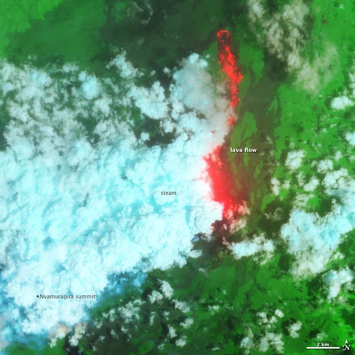
http://earthobservatory.nasa.gov/IOTD/view.php?id=76405quote:n November 6, 2011, after more than a year of relative peace, the Nyamuragira volcano in the Democratic Republic of Congo surged to life. Lava has erupted spectacularly from a fissure low on one of the volcano's flanks and spilled northward, away from populated areas. Nyamuragira is a shield volcano and one of Africa's most active.
For more than a week, cloud cover mostly obscured the view from space until the Advanced Land Imager on NASA’s EO-1 satellite captured images on November 12, 2011. This false-color view combines shortwave infrared, near infrared, and green light. Fresh lava is bright red, an indication that it was active at the time the satellite flew overhead. Billowing, blue-tinged steam clouds rise above the superheated fissure and lava-bathed landscape. In the full-size, wider view (available by link just below the image), the lava lake at nearby Nyiragongo volcano (to the south) glows red through the cloud cover.
A blogger and ranger from Virgunga National Park wrote:
...We hiked a bit further until we came to a section where the vegetation ended and the ground was covered in small pebbles of weightless lava gravel. The thundering roar of the volcano was incredible and the heat of the 100-meter column of lava clearly tangible...The eruption site is truly amazing. It’s located on a flat area, but the sides have been building up around the crack over the last week...The lava has a low silica content resulting in lava with a low viscosity (very fluid), which in turn results in the amazing lava fountain.
Ground-based video of the eruption is available here from the Virunga National Park. Wider satellite views of the landscape around the eruption on November 8 and November 16 are available online through the LANCE/EOSDIS MODIS Rapid Response Team.

quote:Popocatepetl volcano triggers plume 7km high
Amecameca • The Popocatepetl volcano registered an explosion that caused a plume height of 7 kilometers with emission of ash, gas and steam from the crater, and land movement could be felt in Amecameca and even the neighboring municipality of Tlalmanalco .
Civil Protection Director Amecameca, Javier Alonso Meneses said that due to the explosion at 12:02 on Sunday, was ejected incandescent material fell to 8 miles away in parts of Canada Nexpayantla, Amecameca, which originated a fire, which is being stifled by rescue workers.
Relief Corps of the town maintain communication with officials of the eight delegations of the municipality to inform them about the event and avoid panic situations.
Alonso Meneses said that according to the National Center for Disaster Prevention (Cenapred), another more severe scenario, there could be similar events, but said that is informing the public about precautionary measures to be undertaken.
People living in nearby areas felt a vibration after the crash.
Early reports indicate that the explosion was caused by the magnitude of the cone was covered. The fumalora is directed towards the area of Puebla.
quote:Fuego spews ash
The Guatemalan geophysical survey SERNAGEOMIN reports increasing explosive activity from Fuego volcano, one of the country's most active volcanoes. Fuego was observed producing ash clouds reaching 1500-2000 m above the summit crater (at ca. 3600 m altitude) which drifted SW and reached up to 20 km distance where they produced some ash fall, reported in the communities of Panimaché, Morelia, Sangre de Cristo, and Santa Sofía.
The explosions were accompanied by moderate to strong booming noises and shock waves that could be felt in up to 15 km distance. Near-constant rock avalanches are observed on the upper slopes beneath the summit crater, some of which reach the vegetated areas.