WKN Weer, Klimaat en Natuurrampen
Lees alles over het onstuimige weer op onze planeet, volg orkanen en tornado's, zie hoe vulkanen uitbarsten en hoe Moeder Aarde beeft bij een aardbeving. Alles over de verwoestende kracht van onze planeet en tal van andere natuurverschijnselen.


Welkom! Hier alweer het volgende deel in de reeks Hurricane Season! Alle informatie over het ontstaan van nieuwe orkanen in 2011 vind je hier. En natuurlijk volgen we ze allemaal op de voet! Voor zowel Atlantische, Indische als Pacifische stormen kan je hier terecht
Algemene Info
Met de term 'Hurricane Season' bedoelden we in eerste instantie de periode van 1 juni tot 30 november. Deze periode wordt in de Atlantische Oceaan en de Golf van Mexico gezien als het orkaanseizoen. Echter komen deze gewelddadige stormen overal in de wereld voor en met name in Azië zorgen ze jaarlijks voor duizenden slachtoffers en tienduizenden daklozen. Echter horen we vaak erg weinig over de stormen in Azië en juist meer over die in de VS en de Caribbean.
In de laatste jaren zijn Tropische Stormen meer en meer in de media gekomen. Het lijkt ook alsof ze meer en meer slachtoffers maken. Een documentaire over Hurricane Andrew uit 1992, heeft diepe indruk gemaakt en ook zullen kenners orkanen Floyd, Gilbert, Stan en Ivan zich zeker nog herinneren. De catastrofe die "Katrina" met zich meebracht ging de hele wereld over. En dan praten we eigenlijk alleen over de Atlantische stormen en lijken we te vergeten dat er in 2007 meer dan 4000 doden vielen in Bangladesh door orkaan Sidr en orkaan Nargis zorgde voor 80.000 doden in Myanmar alleen al.
Hoewel het Atlantische seizoen pas officieel in juni begint zijn er op andere plekken in de wereld zeker meer orkanen te vinden in de komende maanden. We zullen ook deze dus zeker gaan bespreken. Waarschijnlijk zal de kern van de discussie en de posts gaan over de periode 1 juni tot 30 november. T.z.t. zal er ook wel een NWS-topic worden geopend als een orkaan ook uitgebreid in het nieuws komt.
Orkanen: Hoe ontstaan ze eigenlijk?
Op de site van Wikipedia kan je in het Nederlands nalezen hoe ze ontstaan en wat de belangrijkste energiebron is voor hun verwoestende kracht: het warme zeewater

Ook de BBC heeft er een interessante en leuke animatie over gemaakt.
Ook wordt er op LiveScience in het engels prima uitgelegd hoe ze ontstaan en zich ontwikkelen
Indeling, Kracht en Stormvloed
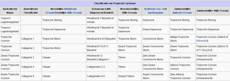
De stormen worden ingedeeld op 'categorie'. Vaak zijn het eerst tropische stormen" (Tropical Depression, Tropical Storms), die overgaan tot Orkaanstatus (Hurricanes/Tyfoons) Ze worden ingedeeld op windsnelheden via de Saffir-Simpson Schaal.
Door de enorme windkracht van een orkaan wordt het zeewater opgestuwd. Dit zeewater wordt als het ware vooruit geblazen, voor de storm uit. Hoe zwaarder de orkaan des te meer zeewater vooruit wordt geduwd. De stormvloed wordt dan ook gemeten bovenop de reguliere golfslag. Je kan het enigszins vergelijken met een muur van water (tsunami) die vooruit wordt geduwd.
Tropische Depressie: windsnelheden van 38 tot 61 km/u
Tropische Storm: windsnelheden van 62 tot 118 km/u
Orkaan 1e categorie: windsnelheden van 119 tot 153 km/u en een stormvloed van 1 tot 1,5 meter boven normaal
Orkaan 2e categorie: windsnelheden van 154 tot 177 km/u en een stormvloed van 1,5 tot 2,5 meter boven normaal
Orkaan 3e categorie: windsnelhden van 178 tot 209 km/u en een stormvloed van 2,5 tot 3,7 meter boven normaal
Orkaan 4e categorie: windsnelheden van 210-249 km/u en een stormvloed van 3,8 tot 5,5 meter boven normaal
Orkaan 5e categorie: windsnelheden > 250 km/u en een stormvloed van meer dan 5,5 meter boven normaal
Onderstaand schema geeft de kracht en benaming van orkanen overal ter wereld weer
TIP: Interactief (film)overzicht van de krachten van orkanen n.a.v. de schaal van Simpson
Waarom hebben orkanen namen?
De Tropische Depressies worden overal ter wereld in de gaten gehouden en zodra de depressies uitgroeien tot orkaan of cycloon, wordt er een naam aan de storm gegeven. Sinds 1950 krijgen ze namen op alfabetische volgorde (met uitzondering van de letters Q, U, X, Y en Z). Mocht een orkaan vernietigend hebben huisgehouden zoals Floyd, Gilbert en bijv. Katrina, dan zal die naam worden vervangen. Soms komt het ook voor dat alle letters van het alfabet gebruikt zijn in één seizoen (zoals 2005), dan zal een volgende storm Alpha gaan heten, gevolgd door Beta etc etc. Voor het orkanenseizoen 2010 zijn de namen als volgt:
Atlantische Stormen 2011
Arlene, Bret, Cindy, Don, Emily, Franklin, Gert, Harvey, Irene, Jose, Katia, Lee, Maria, Nate, Ophelia, Philippe, Rina, Sean, Tammy, Vince, Whitney
In het Noordoosten van de Pacific ontstaan ook orkanen. Deze orkanen zorgen vaak voor overlast in Midden-Amerika en delen van Mexico.
Oost Pacifische Stormen 2011
Adrian, Beatriz, Calvin, Dora, Eugene, Fernanda, Greg, Hilary, Irwin, Jova, Kenneth, Lidia, Max, Norma, Otis, Pilar, Ramon, Selma, Todd, Veronica, Wiley, Xina, York, Zelda
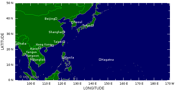
Verder zijn er dan nog de stormen in het Noordenwesten, Midden en Zuiden van de Pacific. Daar worden ze tyfoons en/of cyclonen genoemd. Vooral de stormen in het Noord/Westen komen vaak in het nieuws omdat ze Japan, de Filippijnen, Taiwan en China vaak teisteren, maar ook geheel Zuid Oost Azië kunnen treffen. Ook in de Indische oceaan komen ze voor, daar zijn vaak Bangladesh en Myanmar aan de beurt, maar soms ook India, Pakistan of zelfs Oman.
Meer informatie over de namen van orkanen vind je hier.
Leuk hoor allemaal, maar wanneer zijn die orkaanseizoenen nou precies?
ATLANTISCHE OCEAAN: 1 juni t/m 30 november
NOORD OOST PACIFIC:Begin mei t/m begin november, met piek in augustus/september
NOORD WEST PACIFIC: Begin juli t/m eind november, maar eigenlijk hele jaar door activiteit.
NOORD INDISCHE OCEAAN: april t/m december met pieken in mei en november
ZUID INDISCHE + WEST AUSTRALISCHE OCEAAN: oktober t/m mei met pieken in februari en april
ZUID WEST PACIFIC + OOST AUSTRALISCHE OCEAAN: oktober tot eind april met piek in februari.
Over het algemeen is Mei de rustigste maand en September de zwaarste.
En? Zijn er al verwachtingen en/of voorspellingen voor 2011?
Begin december kwamen de eerste voorspellingen voor 2011 naar buiten. Ze verwachten wederom een zeer actief seizoen. 50 jaar orkaangeschiedenis heeft een zogenaamd gemiddeld orkaanseizoen gecreëerd. Namelijk: 9,6 stormen met naam, 5,9 groeit uit tot orkaan en 2,3 worden superorkanen (cat 4 of 5) Volgens de december verwachting krijgen we 17 tropische stormen in de Atlantische Oceaan. Negen groeien daarvan uit tot orkaan en vijf daarvan zullen superorkanen worden. Er is een kans van 73% dat één van deze 5 superorkanen de kust van de VS zal gaan treffen. Deze voorspelling kan je hier nog eens nalezen.
Waait het nou echt zo hard bij zo'n orkaan?
Oude Delen
2004 - Deel 1 en Deel 2
2005 - Deel 1 en Deel 2
2006 - Deel 1 en Deel 2
2007 - Deel 1, Deel 2, Deel 3 en Deel 4
2008 - Deel 1 en Deel 2
2009 - Deel 1 en Deel 2
2010 - Deel 1 , Deel 2 . Deel 3 en Deel 4
2011 - Deel 1
Enkele Links
1. National Hurricane Centre
2. Carribean Storm Network
3. Hurricanezone
4. Hurricane Track
5. Website met satelietbeelden van de Caribbean en de rest van Amerika
6. Intellicast: Geavanceerde satellietfoto's en gifs van aktuele stormen
7. Tropical Weather Underground
8. Tropical Storm Risico's van dit moment
9. Wikipedia Hurricanes/Tyfonen in het algemeen
10. Alle stormen ter wereld van de laatste jaren in overzicht
11. The StormTrack
12. Orkanensite in de Filipijnen
13. Atlantische Orkanensite
14. Actuele orkanen in Australië en De orkaanindeling in Australië
15. Tropische weersite omgeving Australië
16. Mooie site over Orkanen aan de VS kusten
17. Website van NASA over Hurricanes
18. Windrapporten wereldwijd
19. Storm2k - Amerikaans weerforum
Opmerkelijke Wikipedia-Links
-- Hurricane Katrina 2005
-- Cyclone Nargis 2008
-- Hurricane Season 2011 - Wikipedia
-- Hurricane Season 2010 - Wikipedia
-- Hurricane Season 2009 - Wikipedia
-- Hurricane Season 2008 - Wikipedia
-- Hurricane Season 2007 - Wikipedia
-- Hurricane Season 2006 - Wikipedia
-- Hurricane Season 2005 - Wikipedia
-- Hurricane Season 2004 - Wikipedia
Actuele Weerradar in Golf van Mexico

Actuele Water temperatuur.

=====================
Heb je informatie over orkanen of wil je gewoon alle orkanen van 2011 volgen, volg dan dit topic
[ Bericht 0% gewijzigd door Frutsel op 11-08-2011 11:23:54 ]

quote:Op zaterdag 25 juni 2011 12:38 schreef aloa het volgende:
Volgens Vietnamese media zijn er inmiddels 13 doden, 4 vermisten en 60 gewonden in Vietnam. Veel huizen zijn beschadigd en enkele zijn ingestort. Op sommige plaatsen is meer dan 300 mm regen gevallen. Ook zijn enkele vissersboten beschadigd.
Rijstvelden in Vietnam staan onder water.
De storm kan zelfs voor overlast gaan zorgen in Thailand.
]
 ]
]
Storm eist 16 doden in Vietnam
Zware stormen en regenval hebben de afgelopen dagen in het noorden van Vietnam aan zestien mensen het leven gekost. Twaalf van hen werden getroffen door de bliksem terwijl ze aan het werk waren in rivieren. Dat melden de autoriteiten vandaag.
Vier anderen zijn vermist en 63 zijn gewond geraakt bij de onweders die sinds woensdag huishouden in het land. Volgens de autoriteiten zijn honderden huizen verwoest. De storm is vandaag enigszins gaan liggen.
Het regenseizoen in Vietnam kan nog duren tot eind oktober. Elk jaar vallen er in het land honderden slachtoffers. (afp/adv)
hln

quote:Negen doden door tyfoon in ZuidKorea
\Negen mensen zijn maandag dood aangetroffen en drie anderen zijn vermist na de doortocht van tyfoon Meari in Zuid-Korea. Dat melden de reddingsdiensten.
De storm is nu op weg naar Noord-Korea. Vorige week eiste de tyfoon ook al 30 mensenlevens op de Filipijnen en in Vietnam. (belga/jv)
Ik ben erg benieuwd hoe dit orkaanseizoen zal gaan uitpakken. Kijkende naar het bizarre tornadoseizoen in de VS, zou je haast zeggen dat het met de orkanen ook een geweld wordt.
's Avonds een man, overdags rustig an
Gebied in de Atlantic is nu 30%.. kans is wel aanwezig dat dit wat gaat worden. Vooral Mexico krijgt hier mee te maken.


Tropical Storm Arlene Churns Toward Mexico
Tropical Storm Arlene formed Tuesday evening in the southwest Gulf of Mexico. It is churning toward Mexico with an expected landfall on Thursday. At this time, it is not forecast to become a hurricane.
Outside of some welcome rainfall in far South Texas, Arlene will have no major impacts on the United States.
Heavy rains, flash flooding and mudslides will be the main dangers in Mexico. Below you will find a collection of Arlene maps including our current threat level graphic along with images displaying the current storm information, projected path and tropical storm advisories.


Arlene
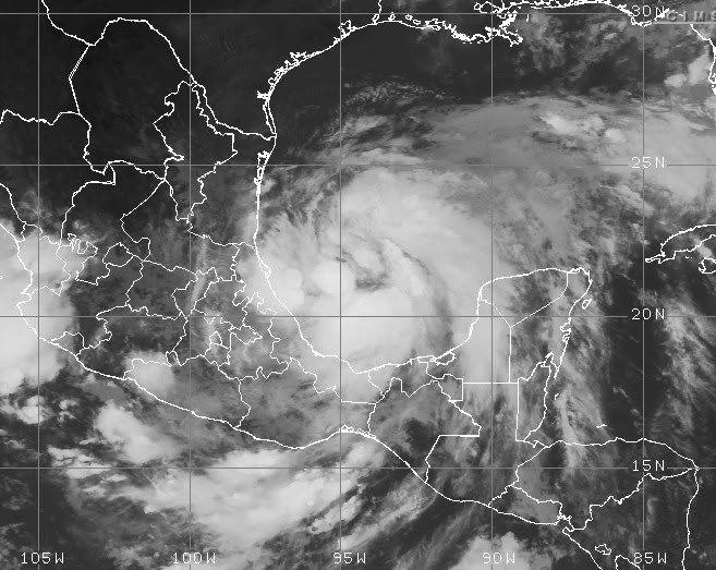
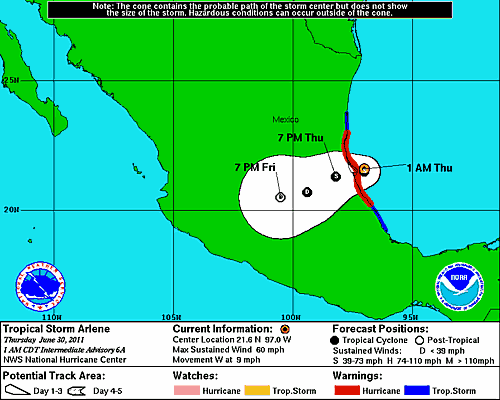
Er is een kans dat Arlene net een orkaan gaat worden. De hoogst windsnelheid die nu wordt verwacht is 111 km/uur. Maar omdat de storm zich goed lijkt te ontwikkelen kan dit wel boven de 120 km/uur uitkomen, waarmee het een cat 1 zal worden.
Momenteel is de storm te vergelijken met een windkracht 9 (Beaufort) waarbij de windstoten oplopen tot net boven de 95 km/uur.
Onderstaande kaartje laat zien dat het aantal mensen, wat overlast kan krijgen van deze storm, kan oplopen tot zo'n 10 miljoen.
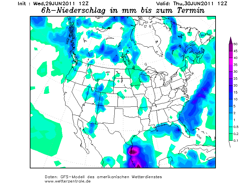
Het neerslagkaartje laat de neerslag zien over 6 uur. In bepaalde delen zal meer (veel meer) dan 50 mm regen vallen.
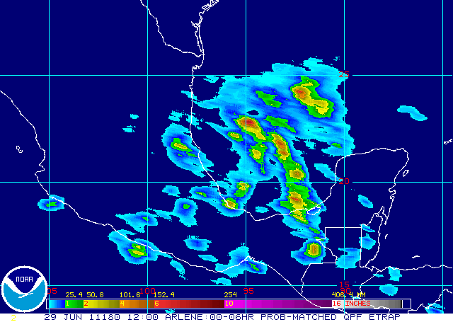
Het huidige neerslagkaartje.
Er is een kans dat Arlene net een orkaan gaat worden. De hoogst windsnelheid die nu wordt verwacht is 111 km/uur. Maar omdat de storm zich goed lijkt te ontwikkelen kan dit wel boven de 120 km/uur uitkomen, waarmee het een cat 1 zal worden.
Momenteel is de storm te vergelijken met een windkracht 9 (Beaufort) waarbij de windstoten oplopen tot net boven de 95 km/uur.
Onderstaande kaartje laat zien dat het aantal mensen, wat overlast kan krijgen van deze storm, kan oplopen tot zo'n 10 miljoen.

Het neerslagkaartje laat de neerslag zien over 6 uur. In bepaalde delen zal meer (veel meer) dan 50 mm regen vallen.
Het huidige neerslagkaartje.
quote:The 2011 Atlantic hurricane season has its first named storm, Tropical Storm Arlene, which rapidly spun up last night from a tropical wave that had emerged into Mexico's Bay of Campeche. An Air Force hurricane hunter aircraft is currently in the storm, and has found that Arlene is strengthening. At the plane's flight altitude of 1,000 feet, top winds reported as of 9:30am EDT were 54 mph, on Arlene's south side. The aircraft's SFMR instrument that remotely measures surface wind speeds found top surface winds of 67 mph on southeast side of the storm. This reading was probably a gust, since top winds of 45 - 50 mph have been more characteristic of the SFMR winds. The measured central pressure at 9am EDT was 1000 mb, which is a 2mb drop from the pressure estimate from 5am. Satellite loops show a marked increase in the intensity and organization of Arlene's heavy thunderstorms, with more prominent spiral bands. Mexican radar out of Alvarado also shows this trend. Wind shear has fallen to the moderate range, 10 - 15 knots, and is predicted to fall to the low range, 5 - 10 knots, by tonight. This should allow Arlene to continue to organize, and storm could be approaching hurricane strength by the time it makes landfall Thursday morning in Northeast Mexico. Arlene has moistened its environment enough so that the dry air over Mexico should no longer be a problem for it, and the topography surrounding the Bay of Campeche tends to boost counter-clockwise air flow, enabling systems there to spin up faster than in any other portion of the Atlantic. Arlene is bigger than most Bay of Campeche tropical storms, though, so it may not have time to spin up into a hurricane because of its large size. NHC's 5am EDT advisory was giving Arlene a 9% chance of reaching hurricane strength before landfall. These odds should probably be bumped up to 30%, in light of Arlene's recent intensification.


Orkaanwaarschuwing Mexicaanse kust om Arlene
MIAMI - De eerste tropische storm van dit seizoen in het Caribisch gebied heeft woensdag (lokale tijd) al direct geleid tot een orkaanwaarschuwing aan de oostkust van Mexico. Arlene zal naar verwachting donderdagochtend (lokale tijd) de kust bereiken. Dat meldt het Amerikaanse orkaancentrum (NHC).
Arlene is nu nog een tropische storm, maar zwelt aan in kracht. Er bestaat volgens de meteorologen een kans dat de storm, net voordat ze de kust raakt, orkaanstatus bereikt.
Ongeacht of dat gebeurt zal de Mexicaanse kust gegeseld worden door windsnelheden van ruim over de 100 kilometer per uur. In de binnenlanden van Mexico wordt plaatselijk anderhalve meter regen verwacht.
Vanwege de naderende storm moeten bewoners van dorpen en steden die direct aan de kust liggen hun huis uit. Ook vreest men voor schade aan boorplatforms voor de kust.
bron
Arlene gaat de drugsmaffia in mexico uitroeien? kan nog wel eens een zware TS Worden als die aan land komt
[b] Hoop gedonder

Vorig jaar hadden ze nog een cat 4, maar dat heeft helaas niets geholpen.quote:Op donderdag 30 juni 2011 11:44 schreef dimage het volgende:
Arlene gaat de drugsmaffia in mexico uitroeien? kan nog wel eens een zware TS Worden als die aan land komt
edit: was een cat 3.
[ Bericht 4% gewijzigd door #ANONIEM op 30-06-2011 12:22:07 ]


Arlene veroorzaakt stortregens in delen van Mexico.
De tropische storm Arlene heeft langs de Mexicaanse Golfkust ter hoogte van Veracruz een ware zondvloed ontketend. In Panuco, provincie Veracruz, viel tussen donderdagochtend en vrijdagochtend 232 mm, in Tierra Blanca, San Luis Potosí, werd 309 mm afgetapt en in Tamesí, Tamaulipas, kwam in 24 uur tijd 349 mm naar beneden. Het noodweer heeft aan drie mensen het leven gekost en een kleine 300.000 mensen zaten tijdelijk zonder stroom.
bron: Jan Visser
Het restant van Arlene ligt nu in de Oost Pacific. Maar gaat waarschijnlijk niets worden.
[ Bericht 0% gewijzigd door #ANONIEM op 02-07-2011 10:17:34 ]
Tropische storm Arlene eist levens in Mexico
PACHUCA - De eerste tropische storm van het seizoen in het Caribisch gebied, Arlene, heeft in Mexico zeker 11 mensenlevens geëist.
Dat meldden de autoriteiten in het Midden-Amerikaanse land zaterdag. Het noodweer trof circa 278.000 mensen.
Arlene bereikte donderdag zonder orkaankracht te bereiken de Mexicaanse kust en nam daarna snel in kracht af.
De stormdepressie die overbleef veroorzaakte vrijdag en zaterdag nog wel zware regenbuien, die in verscheidene deelstaten tot overstromingen hebben geleid.
Vooral het centraal gelegen Hidalgo is zwaar getroffen. Daar zijn zeker vijf doden gevallen en moesten ruim 1000 mensen hun huizen verlaten doordat rivieren buiten hun oevers traden.
Ook in de deelstaten Tamaulipas, Veracruz, San Luis Potosi en Puebla eiste de storm levens, evenals in de hoofdstad Mexico-Stad.
http://www.nu.nl/buitenla(...)evens-in-mexico.html
Orkaan Arlene zaait dood en vernieling in Mexico
In Mexico heeft Arlene, de eerste grote Atlantische orkaan van het seizoen, meteen voor veel leed gezorgd. Volgens de Mexicaanse overheid vielen er minstens zestien doden en raakten 300.000 mensen dakloos.
De orkaan kwam donderdag aan land en hield lelijk huis in het centrum en het oosten. De hoofdstad Mexico City en omgeving werden geteisterd door hevige windstoten. Zware regenval zorgde voor aardverschuivingen. In Oaxaca, in het zuidoosten van het land, viel een dode toen een taxi met negen mensen aan boord door de modder werd meegesleurd. Ook de populaire badstad Acapulco, aan de Stille Oceaan, deelde in de brokken.
Elk jaar tijdens de zomermaanden hebben de landen rond het westelijke deel van de Atlantische Oceaan af te rekenen met een reeks krachtige stormen. Vorig jaar kende Mexico zijn zwaarste orkanenseizoen. De stormen en bijhorende regen zorgden toen voor 125 doden en vernielingen ter waarde van zowat 4 miljard dollar. (afp/adha/svm)
hln


10% potentie in Golf van Mexico
70% nu aan de westkust
[ Bericht 35% gewijzigd door Frutsel op 06-07-2011 20:19:53 ]
70% nu aan de westkust
[ Bericht 35% gewijzigd door Frutsel op 06-07-2011 20:19:53 ]
Lijkt eropquote:
Zo te zien begint het een beetje te komen
[ afbeelding ]
Gebied aan de westkust is inmiddels 100%
Gebied bij Florida lijkt nog de minste kans te hebben om wat te worden. Die in het Caribisch gebied zou wat kunnen worden. Afwachten..quote:
Zo te zien begint het een beetje te komen
[ afbeelding ]


Florida inmiddels 30% die verder weg bijna 0%quote:
[..]
Gebied bij Florida lijkt nog de minste kans te hebben om wat te worden. Die in het Caribisch gebied zou wat kunnen worden. Afwachten..
GFS laat nog een gebied zien tussen Cuba en Venezuela, misschien dat dat nog wat gaat worden begin volgende week.quote:Op vrijdag 8 juli 2011 10:10 schreef Frutsel het volgende:
[..]
Florida inmiddels 30% die verder weg bijna 0%
Calvin is nu te vergelijken met een windkracht 9 (Beaufort) waarbij windstoten voorkomen tot 104 km/uur.
Ah joh, het is nog maar juli. September/Oktober zijn de echte maanden he!quote:
[..]
Florida inmiddels 30% die verder weg bijna 0%
's Avonds een man, overdags rustig an
Augustus anders ookquote:
[..]
Ah joh, het is nog maar juli. September/Oktober zijn de echte maanden he!
Calvin gaat een orkaan worden. De windsnelheid die verwacht wordt is 129 km/uur, waarmee het een cat 1 gaat worden. Het is nu een zeer zware storm (Beaufort 11) met windstoten tot 128 km/uur.
Met een snelheid van 27 km/uur en kerndruk van 997 mb trekt Calvin richting het Westen.
Met een snelheid van 27 km/uur en kerndruk van 997 mb trekt Calvin richting het Westen.
Pfff dit zou wel eens een hele vervelende kunnen gaan worden. Heeft zoveel tijd om aan kracht te winnen en lijkt ook nog eens op Taiwan af te gaan.
Deze ziet er nu al groots uit en is zich goed aan het organiseren. De koers gaat over water wat een temperatuur heeft van ruim 30 graden.
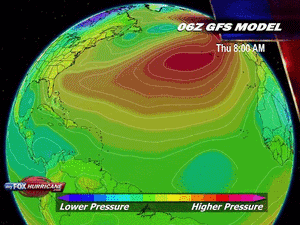
GFS (06z) laat het systeem tussen Taiwan en Japan trekken richting China. (maar dat is nog lang niet zeker).
GFS (06z) laat het systeem tussen Taiwan en Japan trekken richting China. (maar dat is nog lang niet zeker).


Handige site heb ik gevonden misschien kan hij toegevoegd worden in de OP?
Die van 19 juli bij japan ziet er redelijk groot uit
Die van 19 juli bij japan ziet er redelijk groot uit

Dat ziet er uit als een cat 3 of meer...quote:
Handige site heb ik gevonden misschien kan hij toegevoegd worden in de OP?
Die van 19 juli bij japan ziet er redelijk groot uit
[ afbeelding ]
Daar lijkt het inderdaad op. Afwachten maar, voor hetzelfde stormt ie alsnog tussen Japan en Taiwan door en gaat hij recht op China af.quote:
Lijkt echter voor die tijd ook af te buigen. Schampschot?
-----------------
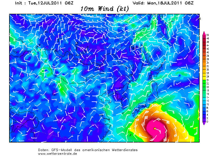
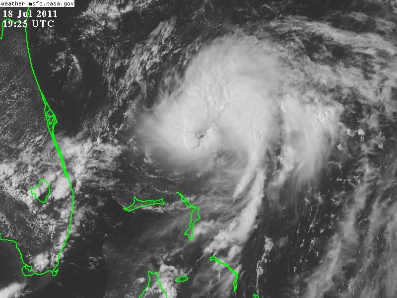
Tropical Storm Ma-On is hard op weg om een orkaan te worden. De orkaan trekt westwaarts met een snelheid van 20 km/uur. De windsnelheid is nu te vergelijken met een windkracht 8 (Beaufort) waarbij windstoten voorkomen tot 80 km/uur.
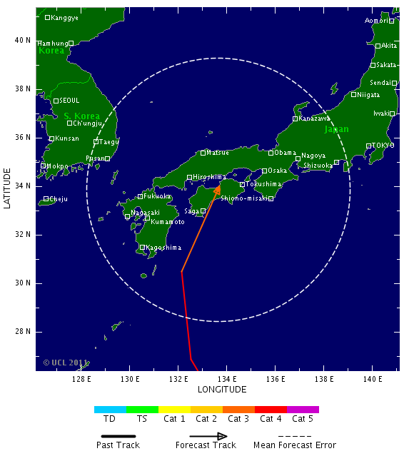
Volgens de verwachting neemt Ma-on langzaam in kracht toe en gaat deze donderdag de orkaanstatus halen. Zoals het nu staat gaat na vrijdag de koers iets meer naar het noorden toe en zal de tyfoon richting Japan trekken. Maar die koers kan nog veranderen.
Kaartje van 19 juli, waarbij de tyfoon voor de kust van Japan ligt
Ma-on is in kracht toegenomen en is nu vergelijkbaar met een windkracht 10 op de schaal van Beaufort. Windstoten lopen op tot net boven de 120 km/uur. De snelheid van de storm is iets teruggelopen tot ongeveer 17 km/uur. Volgens Tropical storm risk gaat het systeem verder activeren en zal deze zaterdag een categorie 3 worden. De hoogste windsnelheid die wordt verwacht ligt boven de 200 km/uur.
Volgens de laatste run van GFS trekt Ma-on richting Japan en zal deze net voor dit eiland afbuigen. (dus geen landfall) Dit zal niet betekenen dat Japan geen overlast zal ondervinden.
Volgens de laatste run van GFS trekt Ma-on richting Japan en zal deze net voor dit eiland afbuigen. (dus geen landfall) Dit zal niet betekenen dat Japan geen overlast zal ondervinden.
Ma-On wordt zeker cat.3, mogelijk zelfs 4. Blijft afwachten in hoeverre Japan hier last van krijgt. Traject lijkt me iets bijgesteld ten nadele van Japan nu.

quote:Powerful typhoon takes aim for Japan
A powerful typhoon could strike mainland Japan early next week.
Widespread adverse rain, wind and sea impact is possible, even for site of the tsunami disaster and nuclear site.
Ma-on, which gained typhoon status east of the Northern Mariana Islands on Wednesday, will intensify markedly over the northern Philippines Sea Thursday through Saturday. This dramatic strengthening of Ma-on could culminate in super typhoon status for a time over open water.
Storm movement, towards the west on Wednesday, is likely to become northwesterly or even northerly by the end of the week.
Given a late-week turn towards the north, the center of Ma-on could be nearing the southwestern shores of Japan early next week packing potentially destructive winds, flooding rain and dangerous storm tides.
Storms of the kind that Ma-on is likely to become can unload extreme rainfall of 10 to 20 inches, with flooding and mudslides, upon reaching Japan.
Depending upon storm intensity at landfall, winds above hurricane strength could unleash widespread destruction.
Greater Tokyo is unlikely to feel the worst of the storm, no matter its ultimate track. Still, flooding rain and damaging winds could take place in the early to middle parts of the week.
Likewise, in northeastern Honshu, at the site of the March tsunami and nuclear disasters, there is the potential for heavy rain, high winds and rough seas next week.

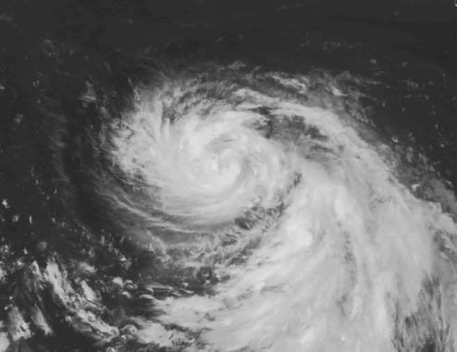
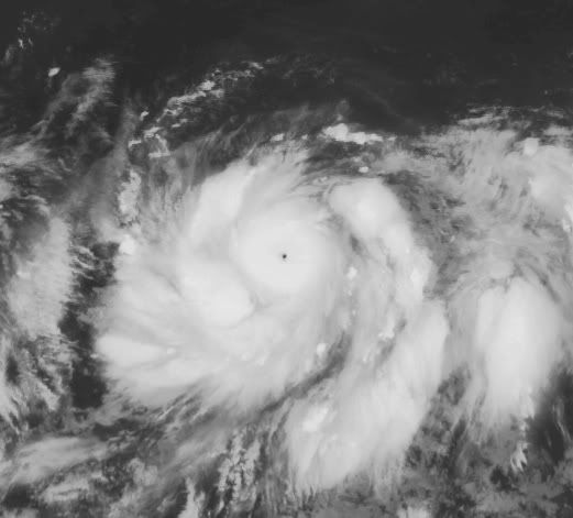
Shot of Typhoon Ma-on taken July 13, 2011

Ma-On inmiddels opgewaardeerd. Haalt zo te zien ook zeker Categorie 4 en gaat mogelijk als Categorie 3 aan land in Japan.
Het wordt druk in de West Pacific. Nu ook aan de oostkant van de Filipijnen een gebied met een hoog risico.

Als de voorspelling zo blijft dan gaat Ma-on woensdag als een categorie 3 landfall maken op Japan. Hierbij kan een windveld voorkomen tussen de 178 en 209 km/uur. De windstoten zullen nog veel hoger zijn.
Loop 10m wind 00z run GFS
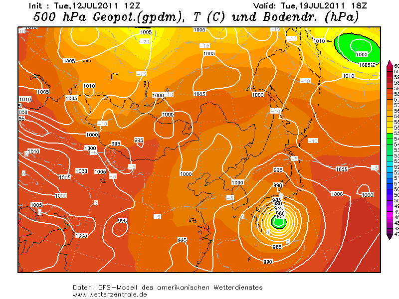
Momenteel is Ma-on een categorie 2 met een windveld van 168 km/uur en windstoten tot net boven de 200 km/uur. Met een snelheid van 30 km/uur trekt het systeem richting het westen. Na vrijdag zal de storm meer naar het noorden trekken richting Japan. De verwachting is dat Ma-on nog verder in kracht zal toenemen en een cat 4 gaat worden op vrijdag. Hierbij zullen windsnelheden worden bereikt die tussen de 210 km en 249 km/uur.
Foto Ma-on, waarbij een nieuw hoog risico gebied is te zien ten oosten van de Filipijnen
[ Bericht 0% gewijzigd door #ANONIEM op 14-07-2011 09:51:20 ]
Loop 10m wind 00z run GFS

Momenteel is Ma-on een categorie 2 met een windveld van 168 km/uur en windstoten tot net boven de 200 km/uur. Met een snelheid van 30 km/uur trekt het systeem richting het westen. Na vrijdag zal de storm meer naar het noorden trekken richting Japan. De verwachting is dat Ma-on nog verder in kracht zal toenemen en een cat 4 gaat worden op vrijdag. Hierbij zullen windsnelheden worden bereikt die tussen de 210 km en 249 km/uur.
Foto Ma-on, waarbij een nieuw hoog risico gebied is te zien ten oosten van de Filipijnen

[ Bericht 0% gewijzigd door #ANONIEM op 14-07-2011 09:51:20 ]

Het lijkt er op dat de storm net voor het eiland richting het noorden/oosten trekt. Het oog kan wel boven het water blijven, maar de watertemperatuur wordt wel een stuk koeler meer naar het noorden, waardoor hij sowieso zal verzwakken wat wind betreft.quote:
Het oog blijft op zee volgens gfs dat is niet het meest ideale toch?
[ afbeelding ]


Die 2 gaan elkaar passeren op zondagquote:
Een 2e storm in de West Pacific.
Ma-on is ondertussen een cat 4.
[ afbeelding ]
Dit wordt een SuperTyfoon.quote:
[..]
Die 2 gaan elkaar passeren op zondagdat zie je niet vaak
Gebeurt niet vaak, volgens mij. De zwakste gaat op in de sterkere orkaan.
Fujiwhara-effectquote:Als twee cyclonen elkaar naderen, zullen de ogen van de beide stormen in een spiraalvorm om een gemeenschappelijk punt draaien, dat tussen beiden in gelegen is. Als het Fujiwara-effect niet wordt onderbroken, dan zal dit doorgaan, totdat de cyclonen zo dicht bij elkaar komen, dat zij in elkaar opgaan. De twee stormen draaien in die richting om elkaar heen, waarin zijzelf ook draaien; dus op het noordelijk halfrond draaien de cyclonen tegen de wijzers van de klok in om het gemeenschappelijke punt en op het zuidelijk halfrond draaien de cyclonen met de wijzers van de klok mee om het gemeenschappelijk punt. Als de twee cyclonen ongeveer gelijk van omvang en sterkte zijn, dan zal het gemeenschappelijke punt ook min of meer in het midden uitkomen. Hoe groter het verschil tussen beide cyclonen, des te dichter het gemeenschappelijke punt bij de grotere, zwaardere storm komt te liggen. Met andere woorden; bij een kleine en een grote cycloon, zal het lijken alsof de kleine om de grote draait, steeds verder naar binnen komt en tenslotte door de grotere cycloon wordt opgenomen. Het effect wordt vooral manifest als 2 tropische cyclonen van tropische-storm-status of meer elkaar naderen tot 1450 km of minder. Meestal wordt het effect door factoren van buitenaf onderbroken en lopen de cyclonen weer van elkaar weg en het samengaan van twee stormen of de opname van de één door de ander is een zeldzaam verschijnsel (bijvoorbeeld Karen in 1995 werd opgenomen door Iris).
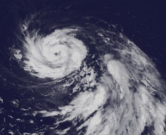
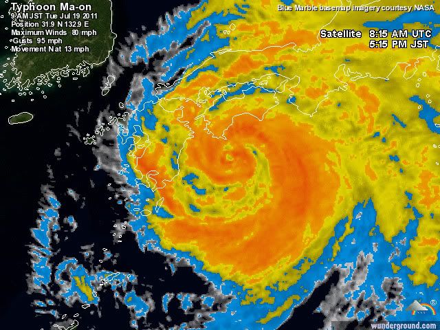
Ma-on heeft de op 1 na hoogste sterkte bereikt en is nu een categorie 4 tyfoon. De windsnelheid is opgelopen tot 209 km/uur. Hierbij komen verwoestende windstoten voor van tegen de 260 km/uur. De snelheid van Ma-on is ongeveer 19 km en de verwachting is nog steeds dat Japan keihard geraakt gaat worden door een categorie 3. Bij een categorie 3 orkaan hoort een stormvloed van 2,5 tot 3,7 meter boven normaal. Ook zal de Tyfoon zorgen voor enorme hoeveelheden neerslag wat voor aardverschuivingen en overstromingen kan gaan zorgen.
Ma-on gaat Tokage opnemen. Op onderstaande kaartjes is goed te zien dat ze op zaterdag 9pm vlakbij elkaar liggen.

Ma-on is iets in kracht afgenomen naar een categorie 3, maar zal waarschijnlijk binnen 24 uur weer in kracht toenemen tot een categorie 4.
In onderstaande loop is te zien hoe de andere storm (Tokage) richting Ma-on trekt.
Het vooruitzicht is dat Ma-on richting Japan trekt en net voor het eiland naar het noorden/oosten trekt en het eiland net een landfall gaat krijgen. Maar dat kan de volgende run weer anders zijn.
[ Bericht 0% gewijzigd door #ANONIEM op 16-07-2011 09:53:50 ]
Met een treksnelheid van 17 km en een windsnelheid van boven de 200 km/uur koerst Ma-on richting Japan. Met windstoten die oplopen tot bijna 250 km/uur is het nog steeds een categorie 3, maar de verwachting is dat de tyfoon nog in kracht zal toenemen en wederom een cat 4 gaat worden. Hierbij zal de windsnelheid oplopen tot net boven de 230 km. De windstoten halen uit tot 277 km/uur.


Inmiddels opgewaardeerd naar Tropical Storm Bretquote:
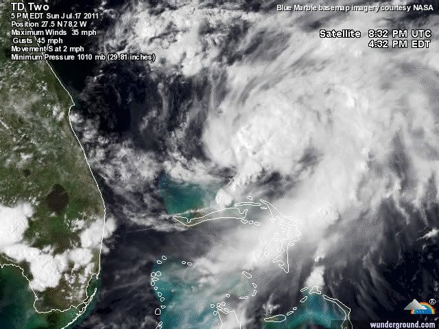
Tropical Depression Two
[ afbeelding ]
[ afbeelding ]
quote:Surfersvillage Global Surf News, 18 July, 2011 : - - Tropical Depression 2 developed Sunday afternoon and strengthened into Tropical Storm Bret Sunday evening. As of 2 a.m. EDT Monday, Tropical Storm Bret was located about 75 miles northwest of Great Abaco Island in the Bahamas, and has winds near 45 miles per hour.
Tropical Storm Bret is expected to strengthen some over the next couple of days, but is currently expected to remain a tropical storm. Tropical Storm Bret was moving very slowly to the south-southeast, around 4 miles per hour. Tropical Storm Bret is expected to move very little through the early morning hours of Monday morning, but begin a slow motion to the north-northeast during the day on Monday.
Bret should bring about two to four inches of rain, with locally heavier amounts possiblle, as well as tropical storm force winds over the northwestern Bahamas. A tropical storm warn is in effect for Grand Bahama Island and the Abaco Islands in the northwestern Bahamas.

quote:Typhoon Ma-on headed towards Japan
Powerful Category 3 Typhoon Ma-on is headed northwestward towards Japan, and is expected to brush the east coast of the main island of Honshu on Tuesday. The typhoon has weakened some over the past day, thanks to an eyewall replacement cycle where the inner eyewall collapsed, and a new, larger eyewall formed from an outer spiral band. Once this process completes, Ma-on is expected to intensify into a Category 4 storm. With water temperatures along the path of the typhoon ranging from 29 - 30°C, and wind shear expected to remain in the low to moderate range of 5 - 15 knots, Ma-on has the potential to hit Japan as a major Category 3 storm. The typhoon is unusually large, with winds of tropical storm force (39+ mph) extending out almost 350 miles to the north of the storm. A large portion of the south coast of Japan will receive tropical storm-force winds and large battering waves from Ma-on. Although the typhoon is currently a minimal Category 3 storm, its large size means that Ma-on has a tremendous amount of total kinetic energy, characteristic of a Category 5 storm. This means that Ma-on has the potential to bring a large and highly destructive storm to the coast on the right front side of where the eye makes landfall. If the eye remains just offshore, as some models are predicting, this storm surge will largely miss Japan, though.
Ma-on is toch verder in kracht afgenomen tot een categorie 2. De windsnelheid is nu 157 km/uur met windstoten tot 193 km/uur. De verwachting is dat de kracht nog iets oploopt tot zo'n 175 km/uur.
Woensdag zal de tyfoon waarschijnlijk landfall maken.
Woensdag zal de tyfoon waarschijnlijk landfall maken.

Inderdaad ja, hoe hoog gaat het dan nog worden, het oog is nu nog bijna 500 km verwijderd van het land.quote:
leuke golfslag daar. Wordt een flinke typhoon daar voor japan
Nog een filmpje...geen flauw idee wat hij allemaal verteld.
quote:
[ Bericht 2% gewijzigd door #ANONIEM op 18-07-2011 12:26:38 ]
Ik denk dat het vandaag nog wel 100% gaat worden.quote:
EastPacific inmiddels 60%... de volgende zal daar idd wel uitkomen
Jan Visserquote:Japan ligt op ramkoers voor wat betreft een krachtige orkaan. Oliver Oeckerath stelde gisteren het volgende bericht samen: "De sterke taifoen "Ma-On" (08W) met een kerndruk van 935 hPa baart de Japanse weerdienst JMA zorgen. Het verder uitdiepende systeem heeft momenteel een kracht van 3 op de Schaal van Saffir-Simpson (gemiddelde maximale windsnelheid 205 km/uur) en stevent met een treksnelheid van18-20 km/uur via de Filipijnenzee af op Kyushu, het zuidelijkste van de vier grote Japanse eilanden, waar het waarschijnlijk maandagavond lokale tijd aan wal zal komen.
Waarschuwingen voor extreem weer zijn ook afgegeven voor Okinawa en Shikoku. Dichtbij het centrum van Ma-On worden windsnelheden gemeten tot 175 km/uur (95 knopen); in vlagen schiet de wind zelfs uit tot 250 km/uur (135 knopen). In de zuidelijke prefecturen van Japan kan de komende dagen tot 500 (!) liter regenwater per vierkante meter naar beneden komen. Er dient rekening gehouden te worden met modderstromen en aardverschuivingen. Ook voor de scheepvaart zal het gezien de zeer hoge golven best gevaarlijk worden." Tot zover het verslag van Oliver.

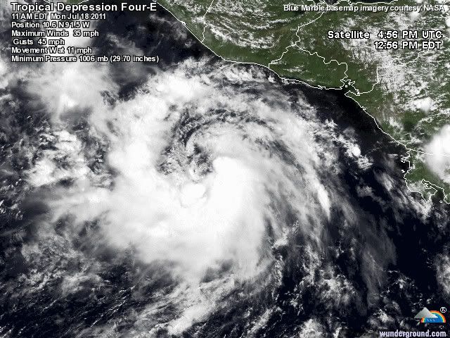
Inmiddels TD 4quote:
90% nu in de oost pacific. Dora komt er aan.

Ma-on is nog zwakker geworden en is nu een cat 1.
De treksnelheid is een stuk sneller nu. (28 km/uur)
De treksnelheid is een stuk sneller nu. (28 km/uur)
Het oog van Ma-on ligt nu heel dicht bij de kust van Japan. De storm is afgebogen richting het oosten en zal nog dichter richting het eiland trekken. Het is nu een categorie 1 met een windsnelheid van 128 km/uur waarbij windstoten voorkomen tot 152 km/uur. De stormvloed die behoort bij een categorie 1 ligt tussen de 1 en 1,5 meter.
Over een aantal uren zal de kracht van de storm afnemen tot ongeveer 100 km/uur, waarmee het een tropische storm zal gaan worden.
Over een aantal uren zal de kracht van de storm afnemen tot ongeveer 100 km/uur, waarmee het een tropische storm zal gaan worden.
Zee gaat flink tekeer
Webcam Japan:
http://carettacamera.dyndns.org/viewer/live/ja/live.html
[ Bericht 24% gewijzigd door #ANONIEM op 19-07-2011 11:19:45 ]
Webcam Japan:
http://carettacamera.dyndns.org/viewer/live/ja/live.html

[ Bericht 24% gewijzigd door #ANONIEM op 19-07-2011 11:19:45 ]


Naast Bret zit inmiddels op de Atlantische Oceaan nog een systeem dat 60% heeft.
Zouden die systemen nog invloed gaan hebben op het weer hierro de komende week als ze richting Europa uitdoven?
Zouden die systemen nog invloed gaan hebben op het weer hierro de komende week als ze richting Europa uitdoven?
Volgens mij niet. Ze lijken me ook te zwak daarvoor.quote:
Naast Bret zit inmiddels op de Atlantische Oceaan nog een systeem dat 60% heeft.
Zouden die systemen nog invloed gaan hebben op het weer hierro de komende week als ze richting Europa uitdoven?
Blijkbaar wel.
stukje van weer.nl
stukje van weer.nl
quote:Bret
Misschien dat in de loop van volgende week toch wat veranderingen zichtbaar zijn op de Amerikaanse en Europese weerkaarten. Op de Atlantische oceaan is namelijk een tropische storm tot ontwikkeling gekomen en de Amerikaanse weerdienst heeft hem de naam Bret meegegeven. Bret blijft op volle zee en zal dan ook geen schade veroorzaken langs de Amerikaanse oostkust. Wel trekt Bret langzaam richting Europa. De warme lucht die met Bret richting Europa komt, kan er weleens voor zorgen dat de koudeput boven West-Europa langzaam van het toneel zal verdwijnen. In dat geval zorgt dus een weersysteem dat aan de andere kant van de Atlantische Oceaan is ontstaan voor een weersverandering in onze streken. In de nieuwste pluimgrafiek is de opwarming al duidelijk zichtbaar.
Bastardi:

Waarom zie ik die niet?quote:Tropical wave in central atlantic near PR sat, Bahamas after. Potential threat Fla, then perhaps gulf after. It has the look of trouble
Ik dacht dat hij bedoelde "Near PR sat" dat die nu bij Puerto Rico zat, maar daar zie ik niets, afgezien van dat 60% gebied wat de oceaan op trekt en niet richting FL/Golfquote:Op woensdag 20 juli 2011 16:56 schreef aloa het volgende:
[..]
ik denk dat hij voor volgende week bedoelt. Dan lijkt daar inderdaad iets te ontstaan.
ecmwf laat daar volgende week een lage druk zien op de kaarten. Gfs trouwens niet.quote:
[..]
Ik dacht dat hij bedoelde "Near PR sat" dat die nu bij Puerto Rico zat, maar daar zie ik niets, afgezien van dat 60% gebied wat de oceaan op trekt en niet richting FL/Golf
Nu zie ik daar ook nietd bijzonders.
http://www.wunderground.c(...)t.html?entrynum=1851quote:An African wave worth watching
An African wave near 45W, midway between the coast of Africa and the Lesser Antilles Islands, is currently generating a limited amount of heavy thunderstorms due to the presence of a large amount of dust and dry air from the Sahara. However, this wave has a modest degree of spin to it, and it is possible it could develop once it finds a moister environment near the Bahama Islands early next week. The last few runs of the UKMET model have shown development of this wave by Tuesday over the Bahamas. The ECMWF and NOGAPS models show that this wave will become a strong tropical disturbance by Tuesday over the Bahamas, while the GFS model shows no development. If this wave does develop, it may recurve before hitting the U.S., since the models agree that there will be a large trough of low pressure present over the U.S. East Coast early next week.


Nieuwe invest in de west pacific. GFS laat deze op de lange termijn tussen Taiwan en de Filipijnen zien. Ook ECMWF laat op de lange termijn een systeem in de buurt van de Filipijnen verschijnen.
op 1 mile na...quote:
Nu 929 en 135kts...
Op het randje van een cat.5

quote:Hurricane Dora in the Eastern Pacific close to Category 5
Hurricane Dora in the Eastern Pacific put on an impressive burst of intensification over the past 24 hours, and is now a very impressive Category 4 storm with 155 mph winds, just 1 mph short of Category 5 status. Dora is expected to move parallel to the coast of Mexico, and should not cause any major trouble in that country. Dora is the second major hurricane in the East Pacific this year; Hurricane Adrian topped out as a Category 4 storm with 140 mph winds in early June.
[ Bericht 5% gewijzigd door #ANONIEM op 21-07-2011 19:03:13 ]
20% inmiddels voor dat gebied. Althans, ik denk dat het die is. Zal dit dan de eerste echte orkaan worden of gaat die ook afbuigen. Krijgen we dit jaar weer zon jaar dat alles afbuigt, net als 2010quote:
[..]
ik denk dat hij voor volgende week bedoelt. Dan lijkt daar inderdaad iets te ontstaan.
Die hittegolf gaat nu naar de oostkust dus misschien word er een blokkade neergezet om afbuiging naar het oosten tegen te gaanquote:
[..]
20% inmiddels voor dat gebied. Althans, ik denk dat het die is. Zal dit dan de eerste echte orkaan worden of gaat die ook afbuigen. Krijgen we dit jaar weer zon jaar dat alles afbuigt, net als 2010Geen idee wat die hittegolf daar voor invloed op heeft.
En invest 90L is up.
Zou een orkaan kunnen gaan worden een koers richting cuba gaan zetten.
Het eerste echte gevaar van 2011.
Zou een orkaan kunnen gaan worden een koers richting cuba gaan zetten.
Het eerste echte gevaar van 2011.
Arlene heeft ook voor flink wat ellende en doden gezorgd. Was net geen orkaan.quote:
En invest 90L is up.
Zou een orkaan kunnen gaan worden een koers richting cuba gaan zetten.
Het eerste echte gevaar van 2011.
[ afbeelding ]
GFS en ECMWF laten nog niets zien. Het NOGAPS model laat begin volgende week wel ontwikkeling zien.
[ Bericht 1% gewijzigd door #ANONIEM op 22-07-2011 19:27:44 ]
Bronquote:Invest 90L: an African wave worth watching
An African wave (Invest 90L) near 14N 55W, 400 miles east of the Lesser Antilles Islands, is moving west-northwest at about 15 - 20 mph. This wave is generating a limited amount of heavy thunderstorms due to the presence of a large amount of dust and dry air from the Sahara, and will spread heavy rain showers and strong gusty winds to the northern Lesser Antilles tonight through Saturday. The wave has a modest degree of spin to it, and is under low wind shear, 5 - 10 knots.
Dry air will continue to be a problem for 90L through Sunday, but once it finds a moister environment near the Bahama Islands early next week, it could develop. However, the expected track of the disturbance takes it over the rugged terrain of Hispaniola, which would inhibit development. Furthermore, wind shear is expected to rise to the moderate range, 10 - 20 knots, on Saturday, and could increase further by Monday, according to most of the computer models. Of the latest 00Z and 06Z runs of the four reliable models for predicting formation of a tropical depression, only the NOGAPS model shows development of 90L. The NOGAPS predicts the wave could attain tropical depression status on Tuesday, over the northwestern Bahama Islands just off the coast of Southeast Florida. The other models generally depict too much wind shear for the wave to develop. Right now, the deck appears stacked against development for 90L through at least Monday. NHC is predicting a 20% chance of development by Sunday. The eventual track of 90L next week has been trending more to the south in recent model runs, as they are generally depicting a weaker trough of low pressure developing over the Eastern U.S. This reduces the chances 90L will move up the U.S. East Coast, and increases the chances that it will enter the Gulf of Mexico.
[ Bericht 1% gewijzigd door #ANONIEM op 22-07-2011 19:27:44 ]
Ben benieuwd of het nog wat gaat worden in de Atlantic. Het ziet er niet heel overtuigend uit nu. Het is niet terug te vinden in de kaarten.
Gebied voor de west pacific ziet er dreigender uit. Dat kan een probleem worden voor de Filipijnen/Taiwan. Halverwege volgende week.
Gebied voor de west pacific ziet er dreigender uit. Dat kan een probleem worden voor de Filipijnen/Taiwan. Halverwege volgende week.


Saffir-Simpson orkaan schaalverdeling wordt aangepast
Het National Hurricane Center (NCH) heeft aangekondigd, dat de schaal betreffende de windsnelheden van orkanen aangepast gaat worden. De verandering in de Saffir-Simpson Hurricane Wind Scale zal minimaal zijn en alleen betrekking hebben op de indeling van de categorie 3, 4 en 5 stormen. De reden waarom de veranderingen worden doorgevoerd is om de conversies tussen knopen, kilometer per uur en mijlen per uur meer accuraat te maken in relatie tot de verschillende orkaan categorieën.
Hoe gaat de Hurricane Wind Speed Scale veranderen?
De grootste verandering vindt plaats in de categorie vier schaal. Momenteel loopt deze van 131 tot 155 mph, 114 tot 135 knopen en 210 tot 249 km/h. Het voorstel van de NHC is om deze te veranderen naar 130 tot 156 mph, 113 tot 136 knopen en 209 tot 251 km/h. Dit impliceert, dat er pas bij een hogere windsnelheid sprake is van een categorie 5 orkaan. De huidige drempel voor een categorie 5 orkaan ligt op 156 mph, 250 km/h en 136 knopen. Na de aanpassing komt de grens te liggen op 157 mph, 252 km/h en 137 knopen. Evenredig gaat ook de bovengrens van de categorie 3 orkanen omlaag; een categorie 3 storm valt binnen de volgende grenzen 111-129 mph, 178-208 km/h en 96-112 knopen.
Alhoewel het geen dramatische veranderingen zijn, maken ze wel een significant verschil bij de conversie tussen de verschillende notatie-eenheden voor windsnelheid en de daarbij behorende waarschuwingen. Hoe zit dit in elkaar?
Het NHC meet de orkaansnelheid in windsnelheid in eenheden van 5 knopen en converteert deze metingen naar mph of km/h wanneer het centrum adviezen cq. waarschuwingen uitgeeft. De meting wordt altijd afgerond naar de dichtstbijzijnde 5 mph of 5 km/h. Dus wanneer een categorie 4 storm maximale windsnelheden heeft van 115 knopen ontstaat er een probleem. De 115 knopen is gelijk aan 132.3 mph. Dit wordt afgerond naar 130 mph, welke onder de categorie 3 intensiteit valt. Met de voorgestelde veranderingen zal het NHC de windsnelheden kunnen converteren voor adviezen en waarschuwingen en blijft daarbij dan in dezelfde categorie. De aanpassing zal geen effect hebben op de historische orkaan gegevens.
Huidige Saffir-Simpson orkaan windsnelheid categorieën
Momenteel zijn er vijf opeenvolgende schalen in de windsterkte. Categorie 1 is de zwakste orkaan en categorie 5 de sterkste, zwaarste orkaan. Iedere storm met windsnelheden minder dan 119 km/h wordt niet geclassificeerd als een orkaan maar als een tropische storm. Het is belangrijk om te onthouden, dat de windsnelheid binnen een orkaan niet evenredig verdeeld is. De hoogste windsnelheden komen vooral voor aan de rechterkant van de orkaan of nabij het oog van de orkaan
* Categorie 1: 74-95 mph; 119-153 km/h; 64-82 knopen
* Categorie 2: 96-110 mph; 154-177 km/h; 83-95 knopen
* Categorie 3: 111-130 (111-129*) mph; 178-209 (178-208*) km/h; 96-113 (96-112*) knopen
* Categorie 4: 131-155 (130-156*) mph; 210-249 (209-251*) km/h; 114-135 (113-136*) knopen
* Categorie 5: Groter of gelijk aan: 156 (157*) mph; 250 (252*) km/h; 136 (137*) knopen
* Voorgestelde windsnelheden
©onweer-online

Negen doden na doortocht tropische storm op Filippijnen
In het oosten van de Filippijnen zijn minstens negen mensen om het leven gekomen door grondverschuivingen en overstromingen veroorzaakt door de tropische storm Nock-Ten.
In de provincie Albay, zo'n 360 kilometer ten zuidoosten van Manilla, vielen zeven slachtoffers. 'Alle dorpen in de provincie staan onder water', aldus provinciaal gouverneur Joey Salceda.
Talloze wegen zijn ontoegankelijk geworden waardoor reddingsteams moeilijk ter plaatse raken. In de naburige provincie Catanduanes kwamen twee mensen om.
Bron
90l staat weer op de kaart. 20% nu.
NHC Invest 90L, Born Again
Invest 90L spiked in thunderstorm activity and circulation yesterday, leading NHC to re-invest the system. 90L is still south of Cuba moving ever-so-slowly to the west. While low level (850mb) circulation has increased since yesterday morning, the system is tilted southeast with height. This is likely due to the westerly wind shear it's facing right now. As the system moves into the Gulf, shear will become more favorable (if there's shear present, easterly is better than westerly). The wave is still moist and moisture is expected to remain high (4 to 5.5 g/kg specific humidity) as it tracks into the Gulf of Mexico.
Again this morning, none of the models are suggesting meaningful development of Invest 90L. However, the GFS (finally) has come around to resolving the circulation at all. Dr. Rob Carver and I spoke this morning, and we came to the conclusion that the lack of observations in this region, combined with the small size of the system, is causing the models to not have the best handle on the situation. The Hurricane Center has a Hurricane Hunter mission scheduled for 18z (2pm EDT) tomorrow, after which we could see the models starting to favor development again. Today the Hurricane Center is forecasting a 20% chance of development over the next 48 hours. I agree with that, but I also think that beyond 48 hours this wave is going to have a better shot at developing a closed circulation at the surface.
NockTen zal voor veel meer doden gaan zorgen wat die is nu ineens enorm aan kracht aan het toenemen.

Het is nu een categorie 1.quote:
NockTen zal voor veel meer doden gaan zorgen wat die is nu ineens enorm aan kracht aan het toenemen.
[ afbeelding ]
Gebied in de Atlantic is nu 70%
[ Bericht 2% gewijzigd door #ANONIEM op 27-07-2011 09:10:16 ]
Als het al wat gaat worden. De kaarten laten nog steeds weinig zien.quote:
70?
die heeft zich ineens ontwikkeld zeg
dat lijkt het eerste serieuze gevaar te worden?
Afwachten maar.
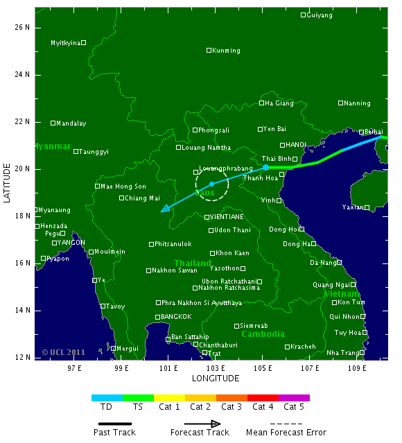
NOCK-TEN trekt na de Filipijnen door richting het zuiden van China en vervolgens is Vietnam weer aan de beurt.
Het dodental op de Filipijnen is opgelopen tot 25. (volgens media op internet).
Het dodental op de Filipijnen is opgelopen tot 25. (volgens media op internet).
![[UGC] Casiguran, Aurora bares the brunt of Juaning](http://i.ytimg.com/vi/YJV6ueZTVEM/default.jpg)
New Tropical Depression Should Form, May Target Texas
"AccuWeather.com meteorologists have pinpointed landfall to occur either late on Friday or Friday night."
A strong tropical wave in the northwestern Caribbean is not only on the verge of organizing into a tropical depression, but may also eventually target Texas.
Interaction with land prevented the tropical wave from wrapping up into an organized tropical system during the past few days.
Now with the wave away from Cuba and over the deep warm water of the northwestern Caribbean, there are signs that an area of low pressure (the next phase of any developing tropical system) is beginning to take shape.
If this trend continues, the birth of the next tropical depression in the Atlantic Basin should occur as early as later today.
The system is forecast to then track through the western Gulf of Mexico tonight into Friday, likely strengthening into Tropical Storm Don in the process.
Without cool water or disruptive wind shear (strong winds high in the atmosphere) ahead of the system to bring about its demise, it is inevitable that the system will make landfall after it enters the western Gulf of Mexico.
AccuWeather.com meteorologists have pinpointed landfall to occur either late on Friday or Friday night. The question is where?
"The key to [the system's] movement will be the strength of the Bermuda high pressure ridge which is nosing westward across Florida into the northern Gulf of Mexico," stated AccuWeather.com Expert Senior Meteorologist John Feerick.
If the ridge maintains its strength, the system will be forced toward South Texas or northern Mexico. The ridge weakening would open the door for the system to target the northwestern Gulf Coast.
Heavy rain and strong, gusty winds would accompany the system wherever it moves inland as a tropical storm (or even a depression).
While flash flooding problems could evolve, the prospect of rain along the western Gulf Coast is definitely news residents want to hear.
Most of coastal Louisiana and Texas are suffering from an extreme to exceptional drought, according to the United States Drought Monitor.
Bron: Accuweather
Tropische storm Nock-ten eist 25 doden in Filipijnen
De tropische storm Nock-ten, die sinds gisteren de Filipijnen teistert, heeft minstens 25 doden gemaakt op Luzon, het grootste eiland van het land. Dat hebben de autoriteiten bericht. Er raakten ook 9 mensen vermist.
Volgens de civiele bescherming zijn de meeste van de 25 dodelijke slachtoffers verdronken of bedolven door aardverschuivingen. (afp/adha)
hln
[ Bericht 0% gewijzigd door #ANONIEM op 27-07-2011 14:26:38 ]

De tropische storm Nock-ten, die sinds gisteren de Filipijnen teistert, heeft minstens 25 doden gemaakt op Luzon, het grootste eiland van het land. Dat hebben de autoriteiten bericht. Er raakten ook 9 mensen vermist.
Volgens de civiele bescherming zijn de meeste van de 25 dodelijke slachtoffers verdronken of bedolven door aardverschuivingen. (afp/adha)


hln
[ Bericht 0% gewijzigd door #ANONIEM op 27-07-2011 14:26:38 ]
Volgens tropical storm risk gaat 'Don' de 50 kts halen. Dat is vergelijkbaar met een windkracht 10 Beaufort. Dus waarschijnlijk gaat het geen orkaan worden.
Maar je weet het maar nooit, soms worden ze ineens sterker dan men verwacht.
Maar je weet het maar nooit, soms worden ze ineens sterker dan men verwacht.
Echt een actief seizoen daar. Zou wat zijn als deze ook al orkaan gaat worden.quote:
20% in de oost pacific. Deze lijkt wel weer een orkaan te gaan worden, volgens GFS.
MUIFA kan ook wel gaan uitgroeien tot een monsterorkaan. GFS laat deze behoorlijk activeren op de lange termijn. De koers gaat nu niet meer richting Japan, maar meer in de richting van Taiwan/China.
Kaartje voor vrijdag 5 augustus
Kaartje voor vrijdag 5 augustus


Op de atlantic nieuw gebied en al meteen 20%
Op een Amerikaans forum waar ik op mee kijk verwachten ze dat redelijk snel de volgende storm kan gaan worden.
Op een Amerikaans forum waar ik op mee kijk verwachten ze dat redelijk snel de volgende storm kan gaan worden.
Welk forum is dat dan?quote:
Op de atlantic nieuw gebied en al meteen 20%
Op een Amerikaans forum waar ik op mee kijk verwachten ze dat redelijk snel de volgende storm kan gaan worden.
Ik volg deze vaak: http://www.wunderground.c(...)t.html?entrynum=1860
Toch nog een kans dat DON een Hurricane Cat.1 wordt vandaag/vanavond.
quote:TS Don has a totally different look to it tonight than it did last night. It is still not very impressive as far as tropical storms go but it is getting better organized. The latest info from the NHC indicates that Don will make landfall somewhere just north of Brownsville, Texas tomorrow night. How strong it will be once it gets there is still in question. There is a window of opportunity for Don to become a hurricane but it could just as easily weaken or simply stay at 50 mph. Why the uncertainty? Because the atmosphere is complex and there are only a few observations in the grand scheme of things for computer models to ingest and make something of. It really is tough- predicting intensity. This is why it is important to be aware and understand tropical cyclones for their hazards and not just numbers like 50 mph or 80 mph. Don will bring heavy rain, squalls with strong winds and coastal surge flooding. The severity of these effects will depend on many factors and whether the storm is pulsing up or breathing out, so to speak. The great thing is that we can monitor on radar from Corpus Christi or Brownsville and see what is going on in near real time.
GFS model zou aangeven dat vanaf komende week Tropische 'waves' vanaf Afrika meer kans van slagen krijgen. Kans dat het seizoen dus nu echt los gaat
www.Storm2k.orgquote:
[..]
Welk forum is dat dan?
Ik volg deze vaak: http://www.wunderground.c(...)t.html?entrynum=1860
En hier wordt er van alles besproken: http://www.storm2k.org/phpbb2/viewforum.php?f=59
En hier gebieden die mogelijk voor gevaar zorgen: http://www.storm2k.org/phpbb2/viewforum.php?f=31
GFS ziet het afbuigen naar de oostkustquote:
[..]
Dit kon wel eens een linke worden... ben benieuwd wat deze gaat brengen.
'Emily' on the move
[ afbeelding ]
kaartje 5-8

Deze kende ik nog niet.quote:
[..]
www.Storm2k.org
En hier wordt er van alles besproken: http://www.storm2k.org/phpbb2/viewforum.php?f=59
En hier gebieden die mogelijk voor gevaar zorgen: http://www.storm2k.org/phpbb2/viewforum.php?f=31
Handig, bedankt.
En daarna waarschijnlijk richting bermuda.quote:
[..]
GFS ziet het afbuigen naar de oostkust
kaartje 5-8
[ afbeelding ]
Of net als Katrina afbuigen naar Florida vervolgens de golf in en uitgroeien tot een monsterorkaanquote:
Ik denk dat deze gewoon de carbbiean in gaat.
Zou wel wat zijn.quote:
[..]
Of net als Katrina afbuigen naar Florida vervolgens de golf in en uitgroeien tot een monsterorkaan

Ik denk ergens morgen TD en later op de dag al TS.
Tropical Storm Battering South China, Vietnam Next
"Major flooding and mudslides are sure to result..."
After leaving more than 40 people dead in the Philippines, Tropical Storm Nock-Ten is now bearing down on South China with Vietnam next in its path.
Nock-Ten, which has remained a tropical storm since briefly reaching typhoon status Tuesday night, will continue to cross the South Chinese island of Hainan today EDT (Friday night local time).
After spending some time over the Gulf of Tonkin and restrengthening into a stronger tropical storm, Nock-Ten will make its final landfall in northern Vietnam on Saturday morning EDT.
Torrential rain will remain the main danger from Nock-Ten across Hainan Island and northern Vietnam. Some wind damage and coastal flooding are other concerns.
Major flooding and mudslides are sure to result from the 10 to 15 inches of rain AccuWeather.com International Expert Meteorologist Jim Andrews warned Nock-Ten would unleash.
The danger for serious flooding will shift to the northern and mountainous areas of Laos and Thailand as this weekend progresses and Nock-Ten transitions to a tropical rainstorm.
The adjective "deadly" is already being attached to Nock-Ten. At least 41 people, according to the AFP, are dead after Nock-Ten's torrential rain triggered flooding and landslides across the Philippines.
Twenty-four other people are reportedly still missing, most of whom are fishermen and crews of small vessels that were likely battered by the large waves stirred by Nock-Ten.
Bron: Accuweather
91l is wel een traag systeem. Heel langzaam trekt het in de richting van de bovenwindse eilanden en lijkt daarna af te buigen naar het noorden/oosten.
Nu nog 30%.
Nu nog 30%.
Don ligt nu voor de kust van Texas/Mexico. In Texas leken ze wel gelukkig met dit systeem, maar het gaat de droogte niet oplossen.. De meeste neerslag lijkt in Mexico te gaan vallen. De windkracht is te vergelijken met een stormkracht 9.
UPDATE.
Begint lekker druk het te worden. En dat is het nog niet eens Aug, Sep of Okt.
91L lijkt vanavond al een TD te kunnen zijn en lijkt zo het carribische gebied in te gaan. Het zou mogelijk ook een gevaar voor de USA kunnen gaan worden.
Tropische storm Don zwakte snel af voordat die aan land ging en heeft zo nog niet echt de hoeveelheid water gebracht die ze zo nodig hadden in Texas. Inmiddels zit de volgende hittegolf in Texas er aan te komen.
Het seizoen lijkt flink actief te gaan worden. In 2010 hadden we om deze tijd pas 2 stormen en in 2009 maar 1 zelfs. Nu lijken het er al 5 te gaan worden.
NockTen heeft inmiddels al voor 50 doden gezorgd in de gebieden waar die is geweest.
En Muifa is binnen 12 uur van een TS naar een Cat.2/3 gegaan en lijkt op volle kracht richting China te gaan. In het ergste geval en zo ziet het er wel uit lijkt de storm Shanghai te raken.
Verder in de oost pacific 2 begieden maar die lijken niks te worden.
Begint lekker druk het te worden. En dat is het nog niet eens Aug, Sep of Okt.
91L lijkt vanavond al een TD te kunnen zijn en lijkt zo het carribische gebied in te gaan. Het zou mogelijk ook een gevaar voor de USA kunnen gaan worden.

Tropische storm Don zwakte snel af voordat die aan land ging en heeft zo nog niet echt de hoeveelheid water gebracht die ze zo nodig hadden in Texas. Inmiddels zit de volgende hittegolf in Texas er aan te komen.
Het seizoen lijkt flink actief te gaan worden. In 2010 hadden we om deze tijd pas 2 stormen en in 2009 maar 1 zelfs. Nu lijken het er al 5 te gaan worden.
NockTen heeft inmiddels al voor 50 doden gezorgd in de gebieden waar die is geweest.
En Muifa is binnen 12 uur van een TS naar een Cat.2/3 gegaan en lijkt op volle kracht richting China te gaan. In het ergste geval en zo ziet het er wel uit lijkt de storm Shanghai te raken.
Verder in de oost pacific 2 begieden maar die lijken niks te worden.
Het lijkt er op dat Typhoon Muifa een categorie 4 gaat halen. De storm heeft nu een windsnelheid van 152 km/uur waarbij windstoten voorkomen tot 193 km/uur.
Er is een mooi oog zichtbaar.
Er is een mooi oog zichtbaar.


"Don" is trouwens in rap tempo verdwenen. Meestal zorgen deze tropische systemen nog wel voor langdurige regen, maar deze lijkt wel in het niets opgelost.
MUIFA is aan het exploderen in de West Pacific. Het is nu een categorie 4.
De windsnelheid loopt op tot 212 km/uur met windstoten tot rond de 258 km/uur.
Zal me niet verbazen als het ook nog een categorie 5 wordt.
[ Bericht 1% gewijzigd door #ANONIEM op 30-07-2011 16:26:27 ]
De windsnelheid loopt op tot 212 km/uur met windstoten tot rond de 258 km/uur.
Zal me niet verbazen als het ook nog een categorie 5 wordt.

[ Bericht 1% gewijzigd door #ANONIEM op 30-07-2011 16:26:27 ]
MUIFA heeft een heel klein oog. ('pinhole eye')
[ Bericht 9% gewijzigd door #ANONIEM op 30-07-2011 19:07:22 ]
http://en.wikipedia.org/wiki/Eye_(cyclone)quote:rapidly intensifying storms can develop an extremely small, clear, and circular eye, sometimes referred to as a pinhole eye. Storms with pinhole eyes are prone to large fluctuations in intensity, and provide difficulties and frustrations for forecasters
[ Bericht 9% gewijzigd door #ANONIEM op 30-07-2011 19:07:22 ]
Mooi knipoogje 
<a href="https://www.youtube.com/channel/UCPueUwKfPaGH7v48LZlltkg" rel="nofollow" target="_blank">WSDokkum Youtube</a>
91l is nu 80%
In de oost pacific een gebied van 40%
[ Bericht 62% gewijzigd door #ANONIEM op 30-07-2011 20:33:21 ]
In de oost pacific een gebied van 40%
[ Bericht 62% gewijzigd door #ANONIEM op 30-07-2011 20:33:21 ]
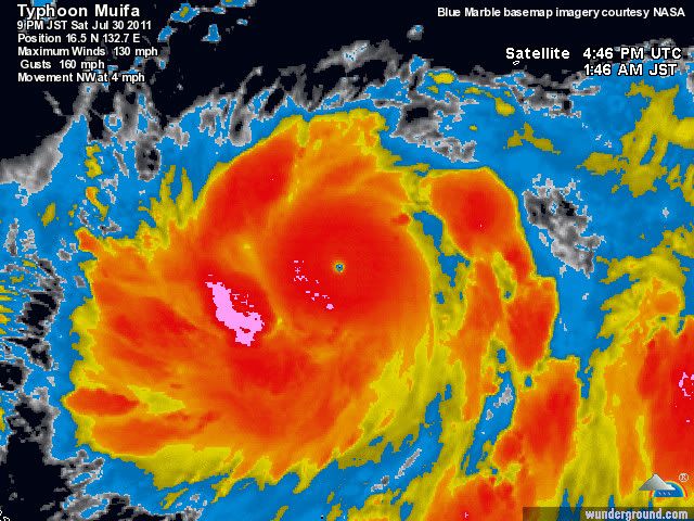
Wat een monster.quote:
Wow Muifa is de sterkste storm van dit jaar tot nu toe.
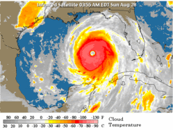
Inmiddels Cat.5 en 899hPa
Windsnelheid van 257 km/uur en windstoten tot 313 km/uur.
Recht op Okinawa af....
155 kts is 287 km/uur
[ Bericht 21% gewijzigd door #ANONIEM op 30-07-2011 23:19:11 ]
155 kts is 287 km/uur

[ Bericht 21% gewijzigd door #ANONIEM op 30-07-2011 23:19:11 ]
Er worden nu windsnelheden van 281km/uur gemeten. En dat zijn nog niet eens de uitschieters.
Dit zou wel eens een van de sterkste typhoon's ooit kunnen worden.
Dit zou wel eens een van de sterkste typhoon's ooit kunnen worden.

MUIFA is nu een cat 4 met windsnelheden die oplopen tot 233 km/uur en windstoten tot 273 km/uur.
De tyfoon heeft echt een slakkengangetje, het beweegt zich voort met maar 6 km/uur.
Aan de temperatuur van het zeewater zal het niet liggen.
De tyfoon heeft echt een slakkengangetje, het beweegt zich voort met maar 6 km/uur.
Aan de temperatuur van het zeewater zal het niet liggen.


Misschien dat het vandaag nog wat gaat worden met 91l en anders zal het morgen worden. Het lijkt er nu op dat het een schampschot gaat worden met Florida. (GFS).
zoals het er nu uit ziet word 91l een volle hit op Florida (GFS)
[ Bericht 8% gewijzigd door Co_OL op 01-08-2011 15:55:23 ]

[ Bericht 8% gewijzigd door Co_OL op 01-08-2011 15:55:23 ]
Denk dat ze vanavond wordt opgewaardeerd naar Emily.quote:
Ja als 91L nog ooit iets gaat worden.
Ziet er steeds minder goed uit.
Gaat langzaam maar gestaag richting TS status
quote:1. THE VIGOROUS TROPICAL WAVE LOCATED ABOUT 250 MILES EAST OF
MARTINIQUE CONTINUES TO SHOW SIGNS OF ORGANIZATION. HOWEVER...AN
AIR FORCE RESERVE RECONNAISSANCE AIRCRAFT INVESTIGATING THE SYSTEM
THIS MORNING DETERMINED THAT THE DISTURBANCE DOES NOT HAVE A CLOSED
SURFACE CIRCULATION CENTER. THE AIRCRAFT DID FIND WINDS OF NEAR
TROPICAL STORM FORCE...AND ENVIRONMENTAL CONDITIONS REMAIN
CONDUCIVE FOR A TROPICAL DEPRESSION OR A TROPICAL STORM TO FORM
LATER TODAY OR TOMORROW. THIS SYSTEM HAS A HIGH CHANCE...90
PERCENT...OF BECOMING A TROPICAL CYCLONE DURING THE NEXT 48 HOURS
AS IT MOVES WEST-NORTHWESTWARD AT AROUND 15 MPH. ANOTHER HURRICANE
HUNTER AIRCRAFT IS SCHEDULED TO INVESTIGATE THE DISTURBANCE THIS
AFTERNOON. IF THE SYSTEM BECOMES A TROPICAL CYCLONE TODAY...
TROPICAL STORM WARNINGS WOULD BE ISSUED FOR PORTIONS OF THE
NORTHERN WINDWARD ISLANDS AND THE LEEWARD ISLANDS ON VERY SHORT
NOTICE. INTERESTS IN THESE AREAS SHOULD CLOSELY MONITOR THE
PROGRESS OF THIS SYSTEM. REGARDLESS OF TROPICAL CYCLONE DEVELOPMENT
OF THIS SYSTEM WILL BRING LOCALLY HEAVY RAINFALL AND GUSTY WINDS TO
PORTIONS OF THE LESSER ANTILLES TODAY AND TONIGHT.
ELSEWHERE...TROPICAL CYCLONE FORMATION IS NOT EXPECTED DURING THE
NEXT 48 HOURS.
$$
FORECASTER STEWART
NNNN

En het is Emilyquote:
[..]
Denk dat ze vanavond wordt opgewaardeerd naar Emily.
Gaat langzaam maar gestaag richting TS status
TS of Cat 1 Als het Florida bereikt.

Ik vraag me af of het nog wat gaat worden met Emily.
Momenteel lijkt het niet meer dan een tropische storm te worden. Kan komen, omdat deze over teveel land trekt, waardoor ze niet in kracht kan toenemen.
Momenteel lijkt het niet meer dan een tropische storm te worden. Kan komen, omdat deze over teveel land trekt, waardoor ze niet in kracht kan toenemen.
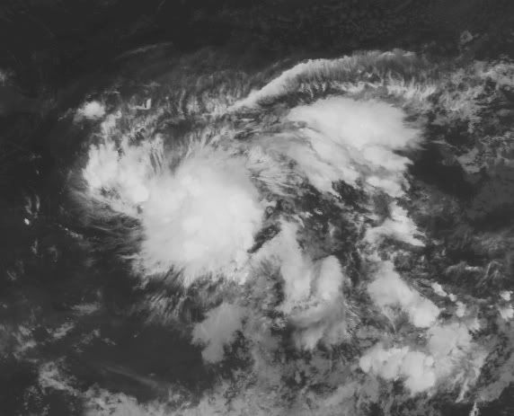


True... feit is wel dat Haiti een pleur water krijgtquote:
Ik vraag me af of het nog wat gaat worden met Emily.
Momenteel lijkt het niet meer dan een tropische storm te worden. Kan komen, omdat deze over teveel land trekt, waardoor ze niet in kracht kan toenemen.
[ afbeelding ]
quote:Forecasting Emily
Model uncertainty is still high for forecasting Emily's track. The 00Z CMC and NOGAPS global models keep Emily on a western track, before recurving to make landfall on the western coast of Florida. The 00Z HWRF and GFDL dynamic
hurricane models both have Emily approaching the eastern coast of Florida, but recurving sharply to the northeast before making landfall. However, the premier global models, GFS and ECMWF, suggest that forecasters should be very cautious.
The 12Z ECMWF did not get a good representation of Emily in its starting conditions, so the forecast Emily did not gain strength and drifted westwards, missing Hispanola. The 00Z GFS does not have any forecast features that could be reasonably associated with Emily in my judgement. From what I can tell, the GFS moves Emily's circulation over Hispanola and Emily then never has a chance to organize. This is disconcerting since the previous 4 runs of the GFS had produced a reasonably robust tropical cyclone with winds near or just exceeding hurricane strength.
Even though the tracks produced by these models are different in their long-term outlooks, they all suggest that Emily will pass by Hispanola close enough for that island's mountains to impact the storm's winds and thus dampen any intensification. However, the 00Z NAM model does not bring Emily near the island, and keeps it moving westwards into the Caribbean sea as a well-organized storm. This, combined with the widely different solutions discussed previously, suggests that people across the Caribbean and living along the Gulf coast should keep an eye on this storm for the next several days.
I would prefer to make an intensity forecast for Emily after it has cleared the island of Hispanola and it's tall mountains. Many storms have weakened considerably after passing by there, and some have dissipated (TS Cindy in 1993, for example).
In light of this uncertainty, the NHC forecast hasn't changed that much. Emily is forecast to turn towards the northwest, making landfall somewhere in southeastern Florida on Saturday as a weak hurricane. (5AM EDT update NHC has adjusted their forecast to the east, so Emily does not make landfall in the next 5 days. Also, Emily does not reach hurricane strength in this forecast.) Tropical storm warnings have been issued for Puerto Rico and the Dominican Republic. A tropical storm watch has been issued for Haiti.
(Bron: Tropical Weather Underground)

S Emily GFDL max wind forecast over the next 126 hours
Erg onduidelijk wat Emily gaat doen...quote:Emily eyes for Haïti
ROUSEAU, Dominica — Tropical Storm Emily was expected to bring heavy rain Tuesday to Puerto Rico after crossing the northeast Caribbean sea on a track that would take it near Haiti within 24 hours.
The storm was expected to bring up to 4 inches of rain to the Leeward and Windward islands and 6 inches to Puerto Rico and the Dominican Republic, enough to cause flash floods and mud slides in areas that have already seen heavy rainfall, the U.S. National Hurricane Center said.
The Weather Channel's hurricane expert Dr. Rick Knabb reported that the storm would likely cross over the mountains of Puerto Rico, which could weaken it.
Haiti and the Dominican Republic were at risk for heavy rains and mudslides, The Weather Channel said.
As the storm passed near Dominica overnight, a weather official urged people to hunker down.
"We are just advising everyone to stay put, stay alert," Senior Acting Meteorological Officer Cheryl Etienne Lebanc said on the state-owned radio station. "Now, might not be the time to be venturing out.
Emily gaat gewoon nog even naar het westen en steekt dan de golf in om een monster te wordenquote:
[ afbeelding ]
S Emily GFDL max wind forecast over the next 126 hours
[..]
Erg onduidelijk wat Emily gaat doen...

quote:Blagoveshchensk Tornado
The Blagoveshchensk tornado is being called one of the strangest weather events in recent memory as meteorologists study the freak Russian tornado. This is the first time in recorded history that a tornado has struck a Russian town.
The Blagoveshchensk tornado took Russian meteorologists by surprise. (from Daily Mail)
People in the far eastern Russian town of about 200,000 are cleaning up the aftermath of the storm, which struck on Sunday. The tornado killed one person, injured around 30, and destroyed cars and tore roofs from houses. Authorities have declared a state of emergency in the town.
Vóór het internet dacht men dat de oorzaak van domheid een gebrek aan toegang tot informatie was. Inmiddels weten we beter.
Dat moet hier. Zeldzaam krachtige tornado treft Russische stadquote:
 Op
Op Dit topic gaat over orkanen.
[ Bericht 8% gewijzigd door #ANONIEM op 02-08-2011 17:14:26 ]
Meh, excusesquote:
[..]
Dat moet hier. Zeldzaam krachtige tornado treft Russische stad
Dit topic gaat over orkanen.
Vóór het internet dacht men dat de oorzaak van domheid een gebrek aan toegang tot informatie was. Inmiddels weten we beter.

Lekker druk begint het te worden.
In de e.pacific is nu ook al een gebied met 70%..
En Emily heeft inmiddels haar eerste slachtoffer gemaakt.
1 dode dus en een hoop schade.
In de e.pacific is nu ook al een gebied met 70%..
En Emily heeft inmiddels haar eerste slachtoffer gemaakt.
1 dode dus en een hoop schade.
Het is elke keer weer anders. Vanmorgen ging deze nog rechtstreeks op Shanghai en nu lijkt het weer Zuid-Korea te worden.quote:
Typhoon Muifa buigt steeds meer af richting Taiwan
Eugene (cat3) Invest 97 (60%) en Emily (Tropische storm)

Tropische Depressie Merbok in de west Pacific

Ow... Zuid Korea, daar kunnen ze nog wel wat water gebruikenquote:
[..]
Het is elke keer weer anders. Vanmorgen ging deze nog rechtstreeks op Shanghai en nu lijkt het weer Zuid-Korea te worden.
quote:'Eugene' strengthens into major hurricane
Hurricane Eugene strengthened into a major category three storm far off the Pacific coast of Mexico on late Tuesday evening, forecasters said. There is no threat to land.
Forecasters at the U.S. National Hurricane Center (NHC) have been following the weather system since Wednesday last week when it emerged as an area of disturbed weather several hundred miles (kilometers) south of the coast of El Salvador and Guatemala. It rapidly became better organized on Saturday and developed into a tropical storm on Sunday morning, before becoming a hurricane on Monday afternoon.
“Eugene continues to strengthen. Since the last advisory deep convection has increased in intensity and coverage and become more symmetric around the eye,” NHC hurricane specialist John Cangialosi said on Tuesday evening. “Dvorak classifications were 90 knots (103 miles/166 kilometres per hour) at 0000Z, but given the improvement in convective organization since then the initial wind speed is set at 100 knots (115 miles/185 kilometres per hour), in agreement with the latest ADT satellite intensity estimates. This makes Eugene a major hurricane, the third of the 2011 Eastern Pacific hurricane season.”
As of 2 a.m. PDT (0900 GMT) on Wednesday, the center of Eugene was located about 570 miles (915 kilometers) south-southwest of the southern tip of the Baja California peninsula in Mexico. It is moving toward the west-northwest at a speed of about 14 miles (22 kilometres) per hour, keeping it far from land.
Maximum sustained winds of Eugene are near 115 miles (185 kilometres) per hour, with higher gusts, making it a category three hurricane on the five-step Saffir-Simpson scale of intensity. The storm is not expected to become a category four hurricane.
“Eugene is moving over slowly cooling sea surface temperatures, and the hurricane is likely near peak intensity,” NHC senior hurricane specialist Jack Beven said on early Wednesday morning. “The new intensity forecast calls for a little strengthening this morning followed by a steady weakening over colder waters, with Eugene expected to weaken to a tropical storm in about 60 to 72 hours, to a tropical depression in about 96 hours, and to a remnant low in about 120 hours.”
Eugene is the fifth named storm of the 2011 Eastern Pacific hurricane season, following Hurricane Dora which formed off the Pacific coast of Mexico earlier this month. As the system stayed far enough from land, Dora caused no damage or casualties.
According to figures released in May, NOAA’s Climate Prediction Center is expecting a below normal hurricane season in the Eastern Pacific this year. The outlook calls for 9 to 15 named storms, with five to eight becoming hurricanes and one to three expected to become a major hurricane (category 3 or higher).
An average Eastern Pacific hurricane season produces 15 to 16 named storms, with eight to nine becoming hurricanes and four becoming major hurricanes. The Eastern Pacific hurricane season runs from May 1 through November 30, with peak activity from July through September.

Noord Korea ook welquote:
[..]
Ow... Zuid Korea, daar kunnen ze nog wel wat water gebruiken
Emily is me wel een rare hoor, nu ineens beweegt ze in oostelijke richting 
[ Bericht 27% gewijzigd door Co_OL op 03-08-2011 20:05:57 ]
[ Bericht 27% gewijzigd door Co_OL op 03-08-2011 20:05:57 ]
Tropische storm teistert Dominicaanse Republiek
In de Dominicaanse Republiek zijn gisteren zo'n 1.647 mensen uit hun woningen geëvacueerd wegens de tropische storm Emily. De storm veroorzaakte hevige neerslag waardoor talloze woningen bedreigd werden door overstromingen. Dat melden de reddingsdiensten.
"Van de 1.647 geëvacueerden vonden er 642 een onderkomen in officiële gebouwen, 1.005 konden terecht bij familie of vrienden", zo luidt het bij het centrum van noodoperaties.
Het merendeel van de evacuaties vond plaats in het zuiden van het land, dat het ergst getroffen werd door de storm. Ook in het naburige Haïti werden de inwoners uit risicozones opgeroepen om de regio te verlaten. (afp/adha)
hln
[ Bericht 1% gewijzigd door #ANONIEM op 04-08-2011 14:06:32 ]
Teveel stof en zand in de lucht in de Centraal Atlantische Oceaan voor de kust van Africa. Weinig kans op ontwikkeling komenende dagen denk ik
Daar hebben ze in de West pacific minder last van. Vandaar dat er daar meer orkanen voorkomen.quote:
Teveel stof en zand in de lucht in de Centraal Atlantische Oceaan voor de kust van Africa. Weinig kans op ontwikkeling komenende dagen denk ik

Ja dat wel, maar net als vorig jaar hebben we meerdere gunstige factoren nodig.quote:
De temperatuur van het water in de golf is lekker hoog
[ afbeelding ]
Komende week zie ik er niet veel gebeuren. Maar goed, tweede helft augustus en september gaat het normaal pas echt los. Ben benieuwd of de VS voor het 2e jaar op rij een orkaan ontwijkt.
Dit gaat dus een druk draadje worden, waarschijnlijk..quote:Hurricane Season Is Looking More Serious
On average, 11 named storms strike the Atlantic basin each year, six of which become hurricanes and two major hurricanes with winds exceeding 111 miles an hour. In May, the National Oceanic and Atmospheric Administration said there was a 65 percent chance that the 2011 hurricane season, which began on June 1, would be above average. It predicted 12 to 18 named storms and six to 10 hurricanes.
With the bulk of storm activity normally in August, September and October, the agency has updated its 2011 hurricane outlook: on Thursday, it said that there is now an 85 percent chance of above-average hurricane activity. Predicted storm numbers have been raised to 14 to 19 named storms, seven to 10 hurricanes and as many as five major hurricanes.
Vóór het internet dacht men dat de oorzaak van domheid een gebrek aan toegang tot informatie was. Inmiddels weten we beter.
Mjah..eerst zien dan geloven.... omstandigheden zijn verre van gunstig op dit moment.. maar goed, tis pas net begonnen. Maar het zal me ook niets verbazen als het net zoals vorig jaar afloopt, terwijl ze toen ook een zeer actief seizoen hadden verwacht
quote:Muifa veroorzaakt dijkdoorbraak bij chemische fabriek
Een tropische storm in het noordoosten van China heeft maandag een gat geslagen in een dijk rond een chemische fabriek. Het leger is ingezet om een milieuramp te voorkomen. Dat meldden Chinese staatsmedia.
De fabriek ligt bij Dalian, ten oosten van de hoofdstad Peking. Door de zware storm Muifa ontstonden tot 20 meter hoge golven, die gaten in de dijk sloegen. Omwonenden zijn geëvacueerd.
Vanwege het naderende noodweer had China eerder al ongeveer een half miljoen mensen geëvacueerd. Voor de oostkust werden meer dan tien vissersboten met circa 200 bemanningsleden vermist. Muifa komt vermoedelijk later maandag bij Dalian aan land.
Eerst zienquote:Orkaanseizoen heviger dan verwacht
Het orkaanseizoen in de Atlantische Oceaan wordt dit jaar heviger dan verwacht. Vooral tegen eind oktober dreigen frequentere en intensievere stormen, voorspelt de Amerikaanse Dienst voor Weer en Oceanografie (NOAA).
Verwacht wordt nu dat er veertien tot negentien stormen met windsnelheden van meer dan 62 kilometer per uur zullen komen - stormen dus die sterk genoeg zijn om een naam te krijgen. Zeven tot tien ervan kunnen orkanen worden, drie tot vijf daarvan orkanen van de categorie 3, 4 of 5. In mei had de NOAA twaalf tot achttien met naam genoemde stormen voorspeld en zes tot tien orkanen.
Volgens de gegevens staat daarmee een boven het gemiddelde actief orkaanseizoen voor de boeg - onder andere begunstigd door buitengewoon warme oceaantemperaturen. Het gemiddelde ligt volgens de NOAA bij elf stormen met namen en zes orkanen. Het Atlantische orkaanseizoen begint telkens op 1 juni en eindigt op 30 november. (belga/sam)
bron: Jan Visserquote:Ondertussen stevent de tropische storm en voormalige taifoen Muifa met een gemiddelde maximale windsnelheid van 100 km/uur (55 knopen) af op Noord-Korea, waar hij vanavond aan wal zal komen. In het noordoosten van China meldde Dalian (provincie Liaoning) om 14 uur lokale tijd reeds 99 mm aan neerslag. Uit voorzorg werden gedurende het weekeinde zo`n 610.000 inwoners van Shanghai en de provincies Fujian, Jiangsu, Zhejiang en Shandong geëvacueerd, maar daar lijkt de schade mee te vallen.
Op het Japanse eiland Okinawa zorgde Muifa afgelopen vrijdag en zaterdag voor een zondvloedscenario. De stad Motobu kreeg in één etmaal tijd t/m zaterdag 8.40 uur een plens van 609 mm te verwerken, waardoor er een nieuw stationsrecord (meetreeks sinds 1981) werd gevestigd. Met dank aan Oliver Oekerath.
quote:Doden bij tropische storm Noord-Korea
(Novum/AP) - SEOUL - De tropische storm Muifa heeft dinsdag in Noord-Korea aan zeker tien mensen het leven gekost. Een onbekend aantal mensen raakte gewond. Daarnaast werden huizen en gewassen vernietigd. Noord-Korea werd vorige maand ook al getroffen door noodweer, dat leidde tot hevige overstromingen.
Muifa kwam maandagavond aan land in Noord-Korea. Ook het noordoosten van China gaat gebukt onder hevige regenval. Volgens de Chinese meteorologische dienst is er daar 13,5 centimeter regen gevallen.
In Noord-Korea is dinsdag meer dan 970 hectare landbouwgrond verwoest. Ook zijn meer dan honderd woningen met de grond gelijk gemaakt. De tropische storm kostte eerder in de Filipijnen al aan vier mensen het leven. Ook in Zuid-Korea kwamen vier mensen om. Hier worden bovendien twee mensen vermist.
Voordat Muifa aan land kwam, beschadigden door de storm veroorzaakte golven een dijk in China. De dijk, die een chemische fabriek in de stad Dalian moet beschermen, is volgens de Chinese autoriteiten versterkt met stenen en beton. Het gevaar voor de fabriek is afgewend, aldus Beijing.
Tropical Storm Muifa Blasts North Korea and China
Tropical Storm Muifa made landfall near the border of North Korea and China late Monday, local time, unleashing torrential rainfall and locally strong winds on the region.
At the time of landfall, maximum sustained winds were between 50-55 mph (80-90 kph), while wind gusts were as high as 60-65 mph (95-105 kph).
However, the main impact from Muifa was the torrential rains unleashed over North Korea and adjacent China. More than 5 inches (125 mm) of rain has fallen over some areas of flood-wary North Korea and China.
Heavy rain also impacted much of South Korea, including Seoul, where at least 1 person lost their life and 2 people remain missing.
In wake of recent months of heavy rain, this heavy rain from Muifa was not needed. This latest round of heavy rain has lead to more than 2,400 acres of damaged crops, according to North Korean officials. Officials also have reported more than 100 houses and 10 public buildings were destroyed from Muifa.
Muifa developed as a tropical depression on July 25th and became a tropical storm on July 28th. Further strengthening ensued, becoming a typhoon on July 30th. In fact, rapid strengthening occurred, and Muifa was briefly a Super Typhoon, with sustained winds near 160 mph (250 kph), on July 31st.
Muifa was a large storm system, with outer rain bands reaching several hundred miles away from the center of the storm. A few of these rain bands reached the northern Philippines, where heavy rain produced flooding and landslides. At least 4 people lost their life over the northern Philippines as a result of the flooding and landslides.
Largely dry weather will settle across North Korea and nearby China for the next few days, allowing cleanup efforts to proceed without many problems. However, by the end of the week, a storm system may approach from the west, with the threat for locally heavy rain returning to the Korean Peninsula and nearby China
Accuweather
bron: Accuweatherquote:Meteorologists in the AccuWeather.com Hurricane Center are still tracking the remains of Tropical Storm Emily, which passed very close to Bermuda Monday. A squall associated with Emily's remains caused a wind gusts as high as 51 mph at Bermuda's L. F. Wade International Airport. As of Tuesday morning, the storm was about 700 miles east-southeast of the island.
Since passing by Bermuda, thunderstorms have begun to cluster around the center and south of weak low pressure leftover from the storm. However, conditions are only marginally favorable for further tropical development in this area of the Atlantic due to lukewarm waters and strong westerly winds aloft.
AccuWeather Expert Senior Meteorologist Dan Kottlowski commented that Emily was looking fairly impressive overnight. "It may have actually been at depression or storm strength for a time, but now is becoming stretched out."
Emily's track has been governed by the midlatitude westerly winds that generally drive storms from west to east around the globe. However, some computer model forecasts are showing that Emily will take a turn to the south in the coming days and track around an area of high pressure that is currently centered several hundred miles southeast of Bermuda. If so, it could eventually end up over waters warm enough to regenerate again.
Some computer guidance that shows Emily turning southward indicate that over the next several days, Emily will curl around the persistent area of high pressure and wind up just north of the Virgin Islands. From there, a track toward the Bahamas again would be likely. Should Emily end up following this path, it should be over very warm waters with favorable wind shear and there would be a good chance of it to regenerate yet again.
It's worth mentioning that the computer model guidance is not in full agreement about Emily following a track that would give the storm a chance to develop into a tropical cyclone once again. Some show Emily stalling over the marginally warm waters southeast of Bermuda, while others show a continued track to the east that curves northward over time.
A track toward the east and northeast would take Emily to cold waters that would prevent further development, while a stall would keep Emily a thorn in the side of weather forecasters for several days.
Kottlowski also commented that, "It looks as though the lowest pressures and turning on the northern end of the cluster of thunderstorms. Most likely, the center of Emily tracks off to the northeast, but some of Emily's energy could get left behind would be a feature that we will have to track."
Kottlowski stressed that this sort of track would be unusual, and that other features had a better chance to develop than Emily. "I'm concerned about the area close to Florida later this week along a front that will become stationary in that area," he said. "We'll also have to watch the large area just west of Africa now, which probably will try to develop eventually once closer to the Lesser Antilles, though not before the end of the week."

3 gebieden nu. Het bovenste gebied zijn de restanten van Emily. Voor de kust van Afrika zal nog een gebied ontstaan wat een behoorlijke orkaan kan worden.
Zo "eindelijk" is een beetje leven daar bij Afrikaquote:
3 gebieden nu. Het bovenste gebied zijn de restanten van Emily. Voor de kust van Afrika zal nog een gebied ontstaan wat een behoorlijke orkaan kan worden.
[ afbeelding ]
Weer of geen weer, altijd actueel www.onweer-online.nl
Jep, het lijkt nu op gang te komen.quote:
[..]
Zo "eindelijk" is een beetje leven daar bij Afrika

93l (nummer 4 voor de kust van Afrika) lijkt de meeste kans te hebben om uit te groeien tot een zware orkaan.

Eerste modellen sturen hem in elk geval langs de oostkust van de VS. Begin volgende week eens kijken hoe dit zich ontwikkeld.quote:
93l (nummer 4 voor de kust van Afrika) lijkt de meeste kans te hebben om uit te groeien tot een zware orkaan.
92l lijkt wat minder te intensiveren dan 93l. Ik denk dat 93l toch wel een cat 2 of meer kan gaan worden. Ze trekken allebei, zoals het nu staat, boven de bovenwindse eilanden e.d. langs.
Golfhoogten tussen de 6 en 10 meter
Golfhoogten tussen de 6 en 10 meter

20% inmiddelsquote:
93l (nummer 4 voor de kust van Afrika) lijkt de meeste kans te hebben om uit te groeien tot een zware orkaan.

Volgens mij gaan ze niet samenvoegen.quote:
Gaan 92l en 93l samenvoegen? 92l gaat met 11 mph en 93l met 13 mph
Ze zijn nu allebei 40%. GFS laat 92l richting Bermuda en New Foundland trekken.

quote:Tropical Concerns for Leewards, Bermuda, Canada
Two tropical systems forecast to soon form in the Atlantic could pass too close for comfort to the Leeward Islands, Bermuda and Atlantic Canada over the next couple of weeks.
As we have been saying here at AccuWeather.com, the Atlantic is locked and loaded with the potential for up to three named systems by August 25.
According to Tropical Weather and Hurricane Expert Dan Kottlowski, "At least two of these systems may become strong enough and whipped around by high pressure in the central Atlantic in such a way as to pass close to or over Bermuda."
Next up could be the Canadian provinces somewhere from New Brunswick to Newfoundland, essentially the Gulf of St. Lawrence region.
The track, let alone formation of the two systems, is in no way set in stone. However, at this point we wanted to make folks aware of two potential troublemakers.
A shift in track is possible with one or both systems. That shift would bring them closer to, or farther away from, the Antilles, the Bahamas and the East Coast of the U.S.
As of late this week, the two systems were mere tropical waves cruising westward, relatively fresh arrivals from the African continent.
These systems, like many others before and after, will have to battle areas of wind shear and dry air, as revealed by dust originating from the Sahara Desert, along the way.
Interestingly, at least two long-range computer models are seeing the two systems at this early stage and developing them, bringing them around the Atlantic high pressure area, and driving them northward through the western Atlantic.
We are not saying the models have a 100 percent right idea on the storms and their supposed tracks, but we are relaying concerns we have in this matter.
On a personal note, I am not a fan of long-range computer model forecasts in the tropics. However, my 28 years of professional forecasting experience tell me that when two commonly used models are essentially predicting the same outcome with minor variances, the situation is worth watching.
If either of the two or both tropical waves slowly organize and become legitimate named tropical systems, they could become strong enough and large enough to have impact on populated areas.
Size, intensity and exact track of the systems will matter as far as local impacts. Even a weak system could bring a period of disruptive, heavy, gusty squalls to island areas such as the Leewards and Virgin Islands.
Both systems will pass nearby the Leeward Islands first. The first system is on track to approach and pass the Leewards spanning Sunday into Monday (Aug. 14 and 15). The second system is due to pass days later; Thursday into Friday of next week (Aug. 18 and 19).
Bermuda may have to deal with the first system spanning Tuesday into Wednesday. The second system would pass near Bermuda the weekend of Aug. 20 and 21.
Part of Atlantic Canada sticks out to the east hundreds of miles relative to the U.S. coast. As a result, at this early stage, people and interests from New Brunswick to Nova Scotia will need to monitor storm development in the tropical Atlantic. The first system would make its run at the region Thursday into Friday of next week (Aug. 18 and 19). The second system would be of concern for the region the week of Aug. 22.
Additionally, shipping and cruising interests will want to watch the situation closely, as the outcome currently most certain is for at least periods of rough seas in the western Atlantic.
Even if both storms were to stay east of the U.S., one or more episodes of rough surf and dangerous rip currents could occur.
Interestingly, it would not take much for an approaching dip in the jet stream to capture one or both systems in such a way as to pull them closer to the East Coast of the U.S.
Kweenie of dit al eens gevraagd is, maar zijn de kwaliteitsposters hier (en elders in DE) vooral amateurs of ook echt professionele meteorologen?
Vóór het internet dacht men dat de oorzaak van domheid een gebrek aan toegang tot informatie was. Inmiddels weten we beter.
Ik denk dat de meeste amateurs zijn.quote:
Kweenie of dit al eens gevraagd is, maar zijn de kwaliteitsposters hier (en elders in DE) vooral amateurs of ook echt professionele meteorologen?
Wat/wie zijn kwaliteitsposters?quote:
Kweenie of dit al eens gevraagd is, maar zijn de kwaliteitsposters hier (en elders in DE) vooral amateurs of ook echt professionele meteorologen?
Iedereen met solide kennis en mooie infographicsquote:
Vóór het internet dacht men dat de oorzaak van domheid een gebrek aan toegang tot informatie was. Inmiddels weten we beter.
Maar dat kun je op internet wel vinden, als je er interesse in hebt.quote:
[..]
Iedereen met solide kennis en mooie infographics
IDD net bij NASA vandaan wat een ding zeg:)quote:
[..]
Maar dat kun je op internet wel vinden, als je er interesse in hebt.
On the Hunt for the Birth of a Hurricane: How the AIRS spaceborne instrument is helping in the campaign to understand some of Earth's most powerful storms

Het ziet er allemaal weer wat minder uit nu. GFS laat de gebieden maar traag ontwikkelen. Volgens GFS gaat 93l op de Bovenwindse eilanden af. ECMWF en NOGAPS laten helemaal niets zien.
Afwachten wat de volgende run gaat doen.
Afwachten wat de volgende run gaat doen.


Mmmm allemaal op elkaar, doet me denken aan vorig jaar. Alles stelde niets meer voor  Wel weer een mooi gezicht met 4 op n rij

Weer of geen weer, altijd actueel www.onweer-online.nl
GFS brengt 93l zelfs nog in de golf (25 Augustus.  ) Beetje ver weg. De nieuwe run loopt nu binnen.
It's a busy day in the tropical Atlantic, with the National Hurricane Center tracking four areas of interest (Invests.) None of these systems is a danger to any land areas over the next three days. The disturbance of most concern is the one farthest from land, a tropical wave that emerged from the coast of Africa two days ago. This wave, (Invest 93L), is located about 500 miles southwest of the Cape Verde Islands, and is moving westward at 15 - 20 mph. Recent visible satellite loops show that 93L has lost some of its heavy thunderstorms since yesterday, and the system is poorly organized, though there is a good deal of spin to the system. There is dry air to its north that is interfering with development. The SHIPS model and University of Wisconsin CIMSS wind shear analysis are showing high wind shear in excess 20 knots affecting 93L, which has undoubtedly contributed to the storm's loss of organization. Sea surface temperatures are 27.5°C, which is one degree above the 26.5°C threshold usually needed to support a tropical storm.
Forecast for 93L
High wind shear above 20 knots is predicted along 93L's path through Saturday afternoon, followed by a drop to the moderate range, 10 - 20 knots, for the succeeding four days. This should allow the storm to organize over the weekend. The latest 00Z and 06Z model runs of the four best models for predicting tropical storm formation (GFS, ECMWF, NOGAPS, and UKMET), have only one model, the GFS, that is indicating significant development of 93L. This model brings 93L near the northern Lesser Antilles Islands by Wednesday. NHC gave 93L a 40% chance of developing into a tropical depression by Sunday morning in their 8am outlook. Given 93L's recent struggles, I'd put these odds at 30%.
92L
An African wave midway between the northern Lesser Antilles Islands and the coast of Africa, near 18°N 45°W, is moving west-northwest at 20 mph. This system, (Invest 92L), is being given a 40% chance of development by NHC. Recent visible satellite loops show a modest amount of heavy thunderstorm activity, but no signs of a surface circulation. A Windsat pass from 8:04 am EDT this morning also showed no surface circulation, and noted top winds of around 35 mph. Water vapor satellite loops show that a large area of dry air surrounds 92L, and this dry air is causing problems for the storm. The SHIPS model and University of Wisconsin CIMSS wind shear analysis are showing moderate wind shear of 10 - 20 knots affecting 92L. Sea surface temperatures are 27 - 27.5°C, which is a degree above the 26.5°C threshold usually needed to support a tropical storm.
Forecast for 92L
Moderate wind shear of 10 - 20 knots is predicted along 92L's path over the coming five days, which should allow the storm to organize if it can handle the dry air surrounding it. The latest 00Z and 06Z model runs of the four best models for predicting tropical storm formation (GFS, ECMWF, NOGAPS, and UKMET) show weak development or no development of 92L, and NHC gave 92L a 40% chance of developing into a tropical depression by Sunday morning in their 8am outlook. A steady west-northwest motion for 92L is predicted by all of the models, which should make the storm miss the Lesser Antilles by a comfortable margin. However, Bermuda may be at risk from 92L next week.
94L
A broad low pressure system about 700 miles northeast of the northern Lesser Antilles Islands has developed a small amount of heavy thunderstorm activity, and may be a threat to become a tropical depression early next week. This system, (Invest 94L), is currently headed west-southwest at 10 mph, but is expected to turn northwest later today. Recent visible satellite loops show some spin to the cloud pattern at middle levels of the atmosphere, but no signs of a surface circulation. This system is also battling dry air, which is keeping the its heavy thunderstorms relatively meager. The SHIPS model is showing moderate wind shear of 10 - 20 knots affecting 94L. Sea surface temperatures are 28°C.
Forecast for 94L
Moderate wind shear of 10 - 20 knots is predicted along 94L's path over the coming five days, which should allow slow development, if it can handle the dry air surrounding it. None of our reliable models for predicting tropical storm formation (GFS, ECMWF, NOGAPS, and UKMET) show no development of 94L, and NHC gave 94L just a 20% chance of developing into a tropical depression by Sunday morning in their 8am outlook. Bermuda is the only land area that needs to be concerned with 94L.
95L
The final invest out there is an area of disturbed weather along on old frontal boundary several hundred miles off the coast of North Carolina. This sytem, Invest 95L, is headed northeastwards out to sea, and is not a threat to any land areas.
Dr. Jeff Masters


Koers van Franklin lijkt gunstig voor ons tot nu toe
Weer of geen weer, altijd actueel www.onweer-online.nl
Ik hoop het..quote:
Koers van Franklin lijkt gunstig voor ons tot nu toe

93l is van de kaarten verdwenen. GFS (andere modellen ook niet) laat het ook niet meer terugkomen in deze run (0.00uur)
Tropische Depressie 7 trekt richting Bermuda..
Tropische Depressie 7 trekt richting Bermuda..

Nu al bij TD 7 en dan Augustus nog worden afgemaakt en komen September en Oktober nog.
Aardig actief dus alleen nog steeds geen orkaan.
Aardig actief dus alleen nog steeds geen orkaan.
Het moet eigenlijk nog allemaal goed op gang komen. Half augustus t/m half oktober (Met de piek in september) is de drukste periode.


 Op
Op
2011 Atlantic Stormsquote:Op zondag 14 augustus 2011 20:16 schreef Frutsel het volgende:
[..]
We moeten nog ff, misschien dat Samson in September of Oktober nog ff langswipt
Arlene Bret Cindy Don Emily Franklin
Gert Harvey Irene Jose Katia Lee
Maria Nate Ophelia Philippe Rina Sean
Tammy Vince Whitney
quote:
ik heb al een mail gestuurd dat ze Sean ff moeten vervangen
Op de hele lange termijn (29 augustus) is er weer een enorm gebied te zien in de golf. Nog ver weg. Dat kan dan een gebied zijn wat achter 93l ontstaat.
[ Bericht 21% gewijzigd door #ANONIEM op 15-08-2011 20:19:42 ]
[ Bericht 21% gewijzigd door #ANONIEM op 15-08-2011 20:19:42 ]

Record Nears: 7 Storms Without a Hurricane
If Tropical Storm Gert, currently churning to the east of Bermuda, fails to strengthen to a hurricane, this year will be the first since record-keeping began to have seven tropical cyclones come and go before the season's first hurricane.
The last time a hurricane season saw so many tropical storms before seeing a hurricane was 2002. That year, Tropical Storm Gustav eventually broke the string by strengthening to a Category 4 hurricane. Gustav struck Louisiana on Sept. 8, killing 112 people.
Gert has only an 8 percent chance of strengthening to a hurricane over the next 72 hours, according to the National Hurricane Center. But even if Gert doesn't become a hurricane, this unprecedented run of tropical storms may not be all that meaningful.
Recent stretches of less powerful tropical storms could be due to the fact that more storms are getting names today than in the past, said Phil Klozbach, a hurricane forecaster at Colorado State University in Fort Collins. Fifty years ago, small tropical storms would have gone unnoticed, whereas today they are being named.
"I wouldn't get too caught up in that [new record] except that it's an interesting piece of trivia," Klozbach told OurAmazingPlanet.
The hurricane forecast from the U.S. National Oceanic and Atmospheric Administration (NOAA) calls for 14 to 19 named storms (which include tropical storms and hurricanes), seven to 10 hurricanes and three to five major hurricanes (Category 3 or higher).
"I'd say if we go another two weeks and there's no hurricane there might be something going on," Klotzbach said.
Hurricane season kicks into high gear around Aug. 20, Klozbach said. Last year was a late-blooming season, but it was unusually active. Those hurricanes might not have been noticed by people in the United States, however, as none of them made landfall in the U.S.
A hurricane has not hit the United States in nearly three years. If no hurricanes hit the United States this year, the 3-year gap would be the longest lull between U.S. hurricane landfalls in recorded history, according to data from the National Oceanic and Atmospheric Administration.
bron
93l is weer behoorlijk verzwakt. 20%
Verderop voor de kust van Afrika lijkt een nieuw gebied te ontstaan.
Verderop voor de kust van Afrika lijkt een nieuw gebied te ontstaan.
Je zal haast verwachten dat de V.S. dit jaar een landfall gaat krijgen. GFS laat om de zoveel tijd een gebied in de Golf zien en in de run van vanmorgen is het een direct hit op Florida.
Kaartje 28augustus
[ Bericht 0% gewijzigd door #ANONIEM op 16-08-2011 11:40:03 ]
Kaartje 28augustus

[ Bericht 0% gewijzigd door #ANONIEM op 16-08-2011 11:40:03 ]


En GFS laat deze doortrekken naar Florida en misschien wel de golf. Ziet er gevaarlijk uit en keert steeds terug in de kaarten. Morgen (of vrijdag) onstaat waarschijnlijk de invest van dit systeem.quote:
GFS laat as zondag een flinke storm zien bij Puerto Rico
[ afbeelding ]
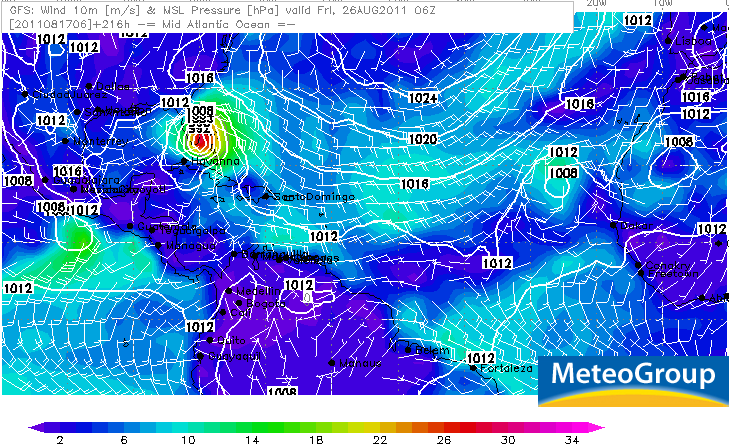

En die Donna...dat was er eentje zegquote:GFS/Euro, forecasting wave as strong as Donna was in 1960 when it came off Africa to emerge off the African coast Sunday
http://en.wikipedia.org/wiki/Hurricane_Donna
Gaat 93l toch nog de volgende storm met een naam krijgen en misschien de eerste orkaan dit seizoen?
wundergroundquote:Caribbean disturbance 93L
A westward-moving tropical wave in the Central Caribbean a few hundred miles south of Hispaniola, Invest 93L, has increased in organization overnight, building up a modest amount of heavy thunderstorms. Low-level spiral bands have begun to form on all sides of the storm this morning. There are currently no signs of a surface circulation, though there is plenty of large-scale rotation apparent on satellite imagery. Dry air surrounds 93L and has infiltrated the center of the disturbance, giving 93L a doughnut-like appearance. However, the disturbance is steadily moistening its environment and is under low wind shear of 5 - 10 knots, so this dry air should gradually mix out today and allow 93L to continue to organize. There is a hurricane hunter mission scheduled for this afternoon at 2pm EDT to see if a tropical depression is forming.
93L will bring heavy rain showers to southern Haiti this afternoon and to Jamaica tonight. By Thursday, 93L's forward motion will slow to 10 - 15 mph, and the storm will bring heavy rains to Northern Honduras and Northeast Nicaragua. These rains will spread to Belize and Mexico's Yucatan Peninsula by Saturday. The latest SHIPS model forecast shows wind shear remaining in the low range and the atmosphere steadily moistening as 93L enters the Western Caribbean on Thursday. All of the models agree that the ridge of high pressure steering 93L to the west will remain strong, forcing the storm into a landfall Friday in Northeast Nicaragua or Northeast Honduras. It is possible that 93L will have time to intensify into a Category 1 hurricane before then, though landfall as a tropical storm would be more likely, given the dry air that 93L needs to overcome. Regardless of development, the storm will bring very heavy rains of 4 - 8 inches or more to Nicaragua and Honduras. These rains are likely to cause dangerous flash flooding and mudslides. NHC gave 93L a 30% chance of developing into a tropical depression by Friday morning in their 8am outlook; I'd put these odds at 50% now, given the continued increase in organization seen on satellite images.

quote:A tropical wave near 14°N 34°W, about 500 miles west-southwest of the Cape Verde Islands off the coast of Africa, is moving westward near 15 - 20 mph. This wave has little heavy thunderstorm activity associated with it due to dry air, but an impressive amount of large-scale spin is obvious in visible satellite loops. This wave is expected to arrive in the Lesser Antilles Islands by Saturday. Three of our four reliable models for predicting tropical storm genesis predict that this wave could develop into a tropical depression sometime Friday through Sunday. A west-northwest track through the Northeast Caribbean bringing the storm near Puerto Rico by Sunday or Monday is favored by most of the models.