WKN Weer, Klimaat en Natuurrampen
Lees alles over het onstuimige weer op onze planeet, volg orkanen en tornado's, zie hoe vulkanen uitbarsten en hoe Moeder Aarde beeft bij een aardbeving. Alles over de verwoestende kracht van onze planeet en tal van andere natuurverschijnselen.


Alsof het weekend is, zoveel zijn er nu online ja.quote:Op donderdag 19 mei 2011 22:47 schreef Ceetje.. het volgende:
de chasers twitteren er op los momenteel
[ afbeelding ]

hebben allemaal wat eerder weekend genomen denk ik. Zou die file daar wel eens live willen zien. Er schijnt trouwens ook een Nederlands chase team te zijn nu, streamen alleen nietquote:Op donderdag 19 mei 2011 22:49 schreef Drassss het volgende:
[..]
Alsof het weekend is, zoveel zijn er nu online ja.
Altijd de sarcasme modus aan
Moet er morgen toch weer vroeg uit dus ik ga je niet zo lang meer verzegelenquote:
ik heb het in de gaten, ach, wacht nog wel een tijdje af
Edit: Tornado warning voor de cell NO van Altus Oklahoma.
Vandaag reist er ook een Nederlander af naar Tornado Alley, hij gaat daar chasen met Cloud9 tours. Mocht hij tijd hebben dan schrijft hij op zijn blog updates. Mensen die interesse hebben kunnen het lezen op zijn site:
http://www.supercell.nl/blogs/index.php?blog=5
http://www.supercell.nl/blogs/index.php?blog=5
Weer of geen weer, altijd actueel www.onweer-online.nl
van wat ik begrepen heb welquote:
Komende dagen weer zwaar weer op komst dus?
Altijd de sarcasme modus aan
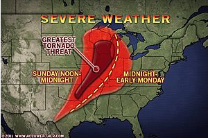
accuweatherquote:"The corridor from Tulsa, Okla., to St. Louis, Mo., to Madison, Wis., stands to be at the greatest risk for tornadic activity into this evening."
Violent thunderstorms, some producing tornadoes, will target cities from the southern Plains through the Great Lakes later this afternoon and this evening ahead of a large storm system.
Thunderstorms this morning are ongoing from central Arkansas through northern Mississippi and western Tennessee, producing flooding downpours and large hail.
An even larger event is on the horizon beginning late this afternoon farther to the west of the current storms.
Sunshine will prevail during the morning and midday hours from Dallas, Texas, through Springfield, Mo., and Chicago, Ill. This sunshine will help to heat up the atmosphere, thereby causing the air to rise.
As a cold front approaches from the west, it will tap into the warm, moist air across the eastern Plains and the Mississippi River Valley, leading to the development of violent thunderstorms by the afternoon hours.
Large hail to the size of baseballs and damaging wind gusts will be the main threats from the strongest thunderstorms. Torrential downpours could trigger flash flooding problems as well.
Tornadoes will also be a problem, especially across the central and northern Mississippi River Valley. The wind shear or "twisting of the winds in the atmosphere" is greater across this region, therefore creating a greater threat for tornadoes.
The corridor from Tulsa, Okla., to St. Louis, Mo., to Madison, Wis., stands to be at the greatest risk for tornadic activity this afternoon and evening.
You better lose yourself in the music
The moment, you own it, you better never let it go
The moment, you own it, you better never let it go
Flinke schade weer in Missouri 
"We meet every day at the same cafe, six-thirty and no one knows she'll be there."
Nou, terwijl wij allemaal sliepen is het toch behoorlijk los gegaan als ik al die berichten zo lees 
http://edition.cnn.com/20(...)er/index.html?hpt=T2
http://www.nu.nl/buitenla(...)n-tornado-in-vs.html
http://edition.cnn.com/20(...)er/index.html?hpt=T2
http://www.nu.nl/buitenla(...)n-tornado-in-vs.html
Opgeblazen gevoel of winderigheid? Zo opgelost met Rennie!

Tientallen doden door tornado in de VS
WASHINGTON - Door een zware wervelstorm in het Middenwesten van de Verenigde Staten zijn zondag zeker dertig doden gevallen. Dit is maandag (onze tijd) vernomen van een plaatselijke lijkschouwer.
De doden vielen in de stad Joplin in de staat Missouri. Naast de doden is een onbekend aantal gewonden gevallen.
Woonhuizen, kerken en een ziekenhuis raakten beschadigd, zo meldden plaatselijke media. Mensen raakten bekneld onder het puin van hun huizen of in vernielde auto's.
Amerikaanse meteorologen bevestigden dat de wervelstorm door het centrum van de stad van zo'n 50.000 inwoners is getrokken.
Enkele weken geleden zijn in de VS 354 doden gevallen door wervelstormen.
nu.nl

Daar is weinig van over, Joplin.. het is/was een bekend plaatsje aan de oude route 66.
Vóór het internet dacht men dat de oorzaak van domheid een gebrek aan toegang tot informatie was. Inmiddels weten we beter.

WTF, wat een schade in Joplin zeg.. Lijkt op (opnieuw) een EF5..
's Avonds een man, overdags rustig an

360 graden foto van de stad na de tornado, zo te zien in de buurt van het ziekenhuis.
Vóór het internet dacht men dat de oorzaak van domheid een gebrek aan toegang tot informatie was. Inmiddels weten we beter.