NWS Nieuws & Achtergronden
Discussieer hier diepgaander over de actualiteiten.


Wat een monster is dat geworden zeg... vanaf Yucatan als Tropische storm en in mum van tijd groeit het ding uit tot een catastrofale Categorie 4 storm. Hier gaat Mexico serieus last van krijgen. Gisteren spraken ze nog van een Cat 1.. hooguit Cat.2... Een geluk is dat de orkaan relatief klein is, maar qua kracht won hij enorm snel in de warme Golf van Mexico.
Je kan het oog ook goed zien

quote:
Karl groeit tot orkaan, koerst naar Mexico
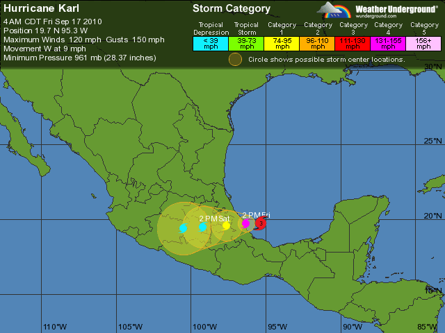
MIAMI - Tropische storm Karl is uitgegroeid tot een orkaan en zal vrijdagmiddag (lokale tijd) de oostkust van Mexico bereiken. Daarbij zal hij snel aan kracht winnen.
Dat meldt het Amerikaanse Orkaancentrum (NHC) donderdag.
De Mexicaanse overheid heeft een orkaanwaarschuwing uitgegeven voor een deel van de oostkust. Karl zal iets ten noorden van de stad Veracruz aan land komen, verwachten meteorologen. De storm zal dan naar verwachting windsnelheden van 160 tot 180 kilometer per uur bereiken. Lokaal kan de orkaan voor 35 centimeter aan regenval zorgen in de binnenlanden van Mexico.
Het NHC waarschuwt bewoners van de kustregio's om zichzelf en hun bezittingen te beschermen tegen de storm. Pemex, het Mexicaanse staatsoliebedrijf, houdt de ontwikkeling van Karl nauwlettend in de gaten, maar de schade aan boorplatformen in de Golf van Mexico lijkt mee te vallen
Gerelateerde topicsquote:Karl could slam into Mexico as a category 4
MEXICO CITY, Sept 17 (Reuters) - Central and southern parts of Mexico's Gulf Coast braced for flash floods and mudslides as Hurricane Karl closed in on the Mexican coast for the second time on Friday.
Karl, building up its winds and bringing the potential of up to 15 inches/(38 cm) of rain, was about 190 miles/(305 km) east-southeast of Tuxpan in the Mexican state of Veracruz as of 1 a.m./0500 GMT, the U.S. National Hurricane Center said.
Karl's winds were up to 120 miles per hour/(194 kph) as the storm moved across the Bay of Campeche in the Gulf of Mexico, where the bulk of Mexico's 2.55 million barrels per day of oil is produced.
Karl, a Category 3 storm on the Saffir-Simpson hurricane wind scale, was expected to make landfall on Friday night.
Mexico's oil industry had to scramble on Thursday after Karl came across the Yucatan Peninsula into the Bay of Campeche.
State-run oil giant Pemex evacuated platforms in the path of the storm and halted production at 14 minor wells, the company said in a statement that did not detail how those measures would disrupt production.
Two of Mexico's main oil exporting ports closed as Karl passed through the region.
Hurricane Season 2010 # 3
Monsterorkaan Igor (Cat.4) op ramkoers met Bermuda
Karl dus vanavond aan land in Mexico... Igor komt zondag aan in Bermuda
Sterkte voor de mensen daar
Meer dan25 miljoen mensen die te maken krijgen met deze orkaan. 
[ Bericht 1% gewijzigd door #ANONIEM op 17-09-2010 11:53:13 ]

[ Bericht 1% gewijzigd door #ANONIEM op 17-09-2010 11:53:13 ]

Dat wordt de boel evacueren 
Ik ben illegaal!
Op woensdag 1 december 2010 16:07 schreef honkeytonk het volgende:Ik denk zelfs dat ze achter de schermen een fantopic over mij hebben geopend :Y
Op woensdag 1 december 2010 16:07 schreef honkeytonk het volgende:Ik denk zelfs dat ze achter de schermen een fantopic over mij hebben geopend :Y
Die Karl toch.
[b]Doe'k 't now wel, doe'k 't now niet of krieg ik spiet
[/b]
[b]Op vrijdag 15 januari 2010 10:36 schreef boudemaniak het volgende:[/b]
Eindbaas ^O^
[/b]
[b]Op vrijdag 15 januari 2010 10:36 schreef boudemaniak het volgende:[/b]
Eindbaas ^O^


Dat is verrekkes hard gegaan zeg. Tering.
Was dit ding gisteren niet nog een onbeduidend niemendalletje?
Was dit ding gisteren niet nog een onbeduidend niemendalletje?

Jep... redelijk...hooguit als Cat.1 orkaan zou die aan land gaanquote:Op vrijdag 17 september 2010 12:30 schreef ZoKanIkHetOok het volgende:
Dat is verrekkes hard gegaan zeg. Tering.
Was dit ding gisteren niet nog een onbeduidend niemendalletje?
Vanavond, mexicaanse tijd, vannacht voor ons dusquote:Op vrijdag 17 september 2010 12:33 schreef opinionr het volgende:
Wanneer verwachten ze hem aan land?
Zie de OP...
Zijn er ook webcams?
Jammer dat er zo weinig weerammateurs zijn daar.
Jammer dat er zo weinig weerammateurs zijn daar.
<a href="https://www.youtube.com/channel/UCPueUwKfPaGH7v48LZlltkg" rel="nofollow" target="_blank">WSDokkum Youtube</a>
Als ik zo de radar kijk is die al aan land gekomen, het oog niet niet maar in deze tempo zou dal al snel zijn. Einde van de middag/avond zal het oog ook al landfall hebben gemaakt.quote:Op vrijdag 17 september 2010 12:39 schreef Frutsel het volgende:
[..]
Jep... redelijk...hooguit als Cat.1 orkaan zou die aan land gaan
[..]
Vanavond, mexicaanse tijd, vannacht voor ons dus
Zie de OP...
<a href="https://www.youtube.com/channel/UCPueUwKfPaGH7v48LZlltkg" rel="nofollow" target="_blank">WSDokkum Youtube</a>


Verslag van reporter ter plaatse:
quote:VERACRUZ, Mexico (AP) — Hurricane Karl grew with surprising speed into a powerful Category 3 storm Friday with forecasters saying it may strengthen further as it roars toward ports and oil installations on Mexico's Gulf Coast.
Karl's maximum sustained winds reached near 120 mph (195 kph), according to the U.S. National Hurricane Center in Miami. Some additional strengthening was possible before the hurricane made landfall, the hurricane center said.
The Mexican government issued a hurricane warning for a 186-mile (300-kilometer) stretch of coast in Veracruz state, stretching northward from the city of the same name. On its predicted path, Karl could make landfall between the port of Veracruz and the oil hub of Poza Rica.
Poza Rica, while slightly inland, houses important pipelines and natural gas- and oil-processing plants operated by the state-owned oil company, Petroleos Mexicanos. Pemex said it had no immediate plans to halt production at the plants because of the storm.
Authorities in Veracruz state — whose southern half has suffered severe flooding over the past few weeks — braced for a hit on its northern coast, preparing sleeping mats, bottled water and other supplies for anyone taking refuge in shelters. Workers in Veracruz city cut dangerous tree limbs that could become flying debris.
About 80,000 people have had their homes damaged and nine people have been killed in flooding from heavy rains in southern Veracruz since Aug. 19. Officials expressed concern Karl could raise river levels again, just as some residents are thinking of returning to their homes.
In the beach town of Tecolutla, just south of Poza Rica, fishermen and operators of small tour boats began pulling their craft out of the water.
Some people boarded up windows with sheets of plywood, lashed down cooking gas tanks and reinforced doors and signs to prevent them from being blow away by the hurricane's wind, said Tecolutla's civil defense director, Edilberto Peralta.
"We are getting ready and warning people early, to avoid any loss of human life," said Peralta, whose town of about 25,000 people was lashed by Hurricane Dean in 2007 and severely flooded by a tropical depression in 1999. "We are ready to take drastic measures."
He said officials were considering whether any residents needed to evacuate their homes.
The port of Tuxpan was closed to small craft Thursday, and Port Capt. Gaspar Cime said larger vessels would be banned later in the day. Tuxpan has about 135,000 people.
By early Friday, Karl was centered 70 miles (110 kilometers) east-northeast of Veracruz. It slowed slightly on its westward path, moving at 9 mph (15 kph).
Meanwhile, Hurricane Igor's top winds also weakened to 125 mph (205 kph) on a track that could take it over Bermuda by Monday. The government of Bermuda issued a hurricane watch.
Farther east over the Atlantic, Hurricane Julia strengthened slightly early Friday, though remained a Category 1 storm with maximum sustained winds of 85 mph (140 kph).
Karl could cause storm surges of 6 to 9 feet (2 to 3 meters) and "large and destructive waves," as well as dump up to 15 inches (40 centimeters) of rain in some areas of Veracruz state, the U.S. National Hurricane Center said in a statement.
As a tropical storm, Karl hit Yucatan on Wednesday, downing tree limbs and causing power outages. The storm made landfall on the Mexican Caribbean coast about midway between the cruise ship port of Majahual and the coastal town of Xcalak.
Associated Press Writer Mark Stevenson in Mexico City contributed to this report.
be nice or go away
Volgens mij gaan ze er nieuwstechnisch toch vanuit dat "landfall" het moment van het oog is?quote:
[..]
Als ik zo de radar kijk is die al aan land gekomen, het oog niet niet maar in deze tempo zou dal al snel zijn. Einde van de middag/avond zal het oog ook al landfall hebben gemaakt.
dacht ik
Klopt.quote:
[..]
Volgens mij gaan ze er nieuwstechnisch toch vanuit dat "landfall" het moment van het oog is?
dacht ik
Oog = landfall, alles draait om het oog en dat is niet zo gek natuurlijk.
Toch als je kijkt naar de radar dan zal dat echt niet landfall maken als wij hier op bed liggen hoor
Maar het is wel een beest, in 1 dagje van prut naar een monster van cat4 inmiddels.
Daar kan onze kanaalratjes nog van leren
<a href="https://www.youtube.com/channel/UCPueUwKfPaGH7v48LZlltkg" rel="nofollow" target="_blank">WSDokkum Youtube</a>
Grote problemen in Mexico vanaf nu t/m zondagavond. Ik denk desondanks wel dat Karl snel zal afzwakken boven land, maar vooral de kust krijgt enorme klappen. 38% kans op een cat. 4, dat zou echt catastrofaal zijn. Dat is een hardere impact dan dat Katrina had in 2005(?)!
's Avonds een man, overdags rustig an
Katrina ging aan land als een Cat3.. maar was net een uurtje of twee daarvoor nog Cat.4. Windsnelheden van ca 200 km/u ofzo.quote:
Grote problemen in Mexico vanaf nu t/m zondagavond. Ik denk desondanks wel dat Karl snel zal afzwakken boven land, maar vooral de kust krijgt enorme klappen. 38% kans op een cat. 4, dat zou echt catastrofaal zijn. Dat is een hardere impact dan dat Katrina had in 2005(?)!
De Stormsurge van 3 tot 4 meter was echter catastrofaal voor die delta...Hoe is dat voor de kust bij Mexico?
Karl zit op dit moment op dezelfde windsnelheden als Katrina toen, wel veel verschil in de druk.
Tis ook even afwachten hoelang hij boven dit gebied blijft hangen en hoeveel regen er gedumpt wordt. Komende dagen zullen er wel aardverschuivingen en modderlawines gaan plaatsvinden
De neerslag zal ook voor veel ellende zorgen. Karl zal een hoop regen laten vallen in de bergen wat vervolgens naar beneden stroomt met alle gevolgen van dien. Modderstromen, aardverschuivingen etc. etc.
Heel veel mensen denken dat de wind de grootste oorzaak is qua schade. Echter is het meer de regen en stormvloed die de grootste schade aanricht van de orkaan. We zullen de komende dagen genoeg nieuwsberichten krijgen daar.
<a href="https://www.youtube.com/channel/UCPueUwKfPaGH7v48LZlltkg" rel="nofollow" target="_blank">WSDokkum Youtube</a>

quote:Hurricane Karl was upgraded overnight to a major Hurricane, a category 3, and forecast to strengthen to 140MPH (Cat 4) by tonight. Rapid intensification happened in the Bay of Campeche and now Mexico (and a lot of us) will likely be caught by surprise. Those in coastal areas should evacuate while there is time (and there isn't much). This level of a hurricane was not forecast a few days ago, but a hurricane watch and warning were issued and is why to treat hurricane watches and warnings seriously.
Landfall will be late in the afternoon or early Evening.
Best of luck and prayers to those in that area of Mexico, they are about to get pounded.
The town most in danger from Karl is Laguna Verde, but Karl is large enough to cause problems a good distance away too.
Laguna Verde is home to Mexico's largest nuclear power plant.
Points just north of the landfall will receive the absolute worst of it. Veracruz will likely see some damage, but not the worst. Storm Surge will be a tremendous issue (!2-15 ft at and north of the landfall point).
Hmm, tussen de 12 en 15 feet, ik ben 5ft4 met mijn 163 cm dus ruwweg 2.5 tot 3.5 keer mij, jikes.....quote:
Hopelijk gaat het allemaal goedkomen met die centrale.
be nice or go away
Dit was inderdaad niet voorspeld. Kan raar gaan met die orkanen.quote:This level of a hurricane was not forecast a few days ago,
Zo te lezen zijn er niet veel mensen geevacueerd i.v.m. te weinig tijd.
Een bekende van me zit daar... hopen dat ie niet wegwaait. 
Het mms plaatje van eergisteren zag er nog zonnig en mooi uit.
Het mms plaatje van eergisteren zag er nog zonnig en mooi uit.
And everything under the sun is in tune
But the sun is eclipsed by the moon.
And Prince is still here!
But the sun is eclipsed by the moon.
And Prince is still here!
Je kan aan de berichten (spelfouten) zien dat ze in haast worden geschreven. (Zoals bovenin Tonight/Tonihgt) Ze raken in paniekquote:
[..]
Hmm, tussen de 12 en 15 feet, ik ben 5ft4 met mijn 163 cm dus ruwweg 2.5 tot 3.5 keer mij, jikes.....
Hopelijk gaat het allemaal goedkomen met die centrale.
Die mensen zijn niet gewaarschuwd voor zon joekel van een storm
|
|