WKN Weer, Klimaat en Natuurrampen
Lees alles over het onstuimige weer op onze planeet, volg orkanen en tornado's, zie hoe vulkanen uitbarsten en hoe Moeder Aarde beeft bij een aardbeving. Alles over de verwoestende kracht van onze planeet en tal van andere natuurverschijnselen.


Welkom! Hier alweer het volgende deel in de reeks Hurricane Season! Alle informatie over het ontstaan van nieuwe orkanen in 2010 vind je hier. En natuurlijk volgen we ze allemaal op de voet! Voor zowel Atlantische, Indische als Pacifische stormen kan je hier terecht
Algemene Info
Met de term 'Hurricane Season' bedoelden we in eerste instantie de periode van 1 juni tot 30 november. Deze periode wordt in de Atlantische Oceaan en de Golf van Mexico gezien als het orkaanseizoen. Echter komen deze gewelddadige stormen overal in de wereld voor en met name in Azië zorgen ze jaarlijks voor duizenden slachtoffers en tienduizenden daklozen. Echter horen we vaak erg weinig over de stormen in Azië en juist meer over die in de VS.
In de laatste jaren zijn Tropische Stormen meer en meer in de media gekomen. Het lijkt ook alsof ze meer en meer slachtoffers maken. Een documentaire over Hurricane Andrew uit 1992, heeft diepe indruk gemaakt en ook zullen kenners orkanen Floyd, Gilbert, Stan en Ivan zich zeker nog herinneren. De catastrofe die "Katrina" met zich meebracht ging de hele wereld over. En dan praten we eigenlijk alleen over de Atlantische stormen en lijken we te vergeten dat er in 2007 meer dan 4000 doden vielen in Bangladesh door orkaan Sidr en orkaan Nargis zorgde voor 80.000 doden in Myanmar alleen al.
Hoewel het Atlantische seizoen pas officieel in juni begint zijn er op andere plekken in de wereld zeker meer orkanen te vinden in de komende maanden. We zullen ook deze dus zeker gaan bespreken. Waarschijnlijk zal de kern van de discussie en de posts gaan over de periode 1 juni tot 30 november. T.z.t. zal er ook wel een NWS-topic worden geopend als een orkaan ook uitgebreid in het nieuws komt.
Orkanen: Hoe ontstaan ze eigenlijk?
Op de site van Wikipedia kan je in het Nederlands nalezen hoe ze ontstaan en wat de belangrijkste energiebron is voor hun verwoestende kracht: het warme zeewater

Ook de BBC heeft er een interessante en leuke animatie over gemaakt.
Ook wordt er op LiveScience in het engels prima uitgelegd hoe ze ontstaan en zich ontwikkelen
Indeling, Kracht en Stormvloed
De stormen worden ingedeeld op 'categorie'. Vaak zijn het eerst tropische stormen" (Tropical Depression, Tropical Storms), die overgaan tot Orkaanstatus (Hurricanes/Tyfoons) Ze worden ingedeeld op windsnelheden via de Saffir-Simpson Schaal.
Door de enorme windkracht van een orkaan wordt het zeewater opgestuwd. Dit zeewater wordt als het ware vooruit geblazen, voor de storm uit. Hoe zwaarder de orkaan des te meer zeewater vooruit wordt geduwd. De stormvloed wordt dan ook gemeten bovenop de reguliere golfslag. Je kan het enigszins vergelijken met een muur van water (tsunami) die vooruit wordt geduwd.
Tropische Depressie: windsnelheden van 38 tot 61 km/u
Tropische Storm: windsnelheden van 62 tot 118 km/u
Orkaan 1e categorie: windsnelheden van 119 tot 153 km/u en een stormvloed van 1 tot 1,5 meter boven normaal
Orkaan 2e categorie: windsnelheden van 154 tot 177 km/u en een stormvloed van 1,5 tot 2,5 meter boven normaal
Orkaan 3e categorie: windsnelhden van 178 tot 209 km/u en een stormvloed van 2,5 tot 3,7 meter boven normaal
Orkaan 4e categorie: windsnelheden van 210-249 km/u en een stormvloed van 3,8 tot 5,5 meter boven normaal
Orkaan 5e categorie: windsnelheden > 250 km/u en een stormvloed van meer dan 5,5 meter boven normaal
TIP: Interactief (film)overzicht van de krachten van orkanen n.a.v. de schaal van Simpson
Waarom hebben orkanen namen?
De Tropische Depressies worden overal ter wereld in de gaten gehouden en zodra de depressies uitgroeien tot orkaan of cycloon, wordt er een naam aan de storm gegeven. Sinds 1950 krijgen ze namen op alfabetische volgorde (met uitzondering van de letters Q, U, X, Y en Z). Mocht een orkaan vernietigend hebben huisgehouden zoals Floyd, Gilbert en bijv. Katrina, dan zal die naam worden vervangen. Soms komt het ook voor dat alle letters van het alfabet gebruikt zijn in één seizoen (zoals 2005), dan zal een volgende storm Alpha gaan heten, gevolgd door Beta etc etc. Voor het orkanenseizoen 2010 zijn de namen als volgt:
Atlantische Stormen 2010
Alex, Bonnie, Colin, Danielle, Earl, Fiona, Gaston, Hermine, Igor, Julia, Karl, Lisa, Matthew, Nicole, Otto, Paula, Richard, Shary, Tomas, Virginie, Walter.
In het Noordoosten van de Pacific ontstaan ook orkanen. Deze zorgen meestal voor weinig schade aan de Amerikaanse/Mexicaanse westkust.
Oost Pacifische Stormen 2010
Agatha, Blas, Celia, Darby, Estelle, Frank, Georgette, Howard, Isis, Javier, Kay, Lester, Madeline, Newton, Orlene, Paine, Roslyn, Seymour, Tina, Virgil, Winifred, Xavier, Yolanda, Zeke
Verder zijn er dan nog de stormen in het Noorden, Zuiden en Westen van de Pacific. Daar worden ze tyfoons en/of cyclonen genoemd. Vooral de stormen in het Noord/Westen komen vaak in het nieuws omdat ze Japan, de Filippijnen, Taiwan en China vaak teisteren, maar ook geheel Zuid Oost Azië kunnen treffen. Meer informatie over de namen van orkanen vind je hier.
Leuk hoor allemaal, maar wanneer zijn die orkaanseizoenen nou precies?
ATLANTISCHE OCEAAN: 1 juni t/m 30 november
NOORD OOST PACIFIC:Begin mei t/m begin november, met piek in augustus/september
NOORD WEST PACIFIC: Begin juli t/m eind november, maar eigenlijk hele jaar door activiteit.
NOORD INDISCHE OCEAAN: april t/m december met pieken in mei en november
ZUID INDISCHE + WEST AUSTRALISCHE OCEAAN: oktober t/m mei met pieken in februari en april
ZUID WEST PACIFIC + OOST AUSTRALISCHE OCEAAN: oktober tot eind april met piek in februari.
Over het algemeen is Mei de rustigste maand en September de zwaarste.
En? Zijn er al verwachtingen en/of voorspellingen voor 2010?
Begin december kwamen de eerste voorspellingen voor 2010 naar buiten. Ze verwachten een boven gemiddeld seizoen. 50 jaar orkaangeschiedenis heeft een zogenaamd gemiddeld orkaanseizoen[/b] gecreëerd. 9,6 stormen met naam, 5,9 groeit uit tot orkaan en 2,3 worden superorkanen (cat 4 of 5) Volgens de decemberverwachting is de verwachting dat er in 2010 elf tot zestien ‘naam-stormen’ zullen ontstaan in de Atlantische Oceaan. Zes tot acht groeien uit tot orkaan en drie tot vijf daarvan zullen superorkanen worden. Deze voorspelling kan je hier of hier nog eens nalezen.
[b]Oude Delen
2004 - Deel 1 en Deel 2
2005 - Deel 1 en Deel 2
2006 - Deel 1 en Deel 2
2007 - Deel 1, Deel 2, Deel 3 en Deel 4
2008 - Deel 1 en Deel 2
2009 - Deel 1 en Deel 2
2010 - Hurricane Season 2010 - Things are about to change...
2010 - Hurricane Season 2010 # 2
Enkele Links
1. National Hurricane Centre
2. Carribean Storm Network
3. Hurricanezone
4. Hurricane Track
5. Website met satelietbeelden van de Caribbean en de rest van Amerika
6. Intellicast: Geavanceerde satellietfoto's en gifs van aktuele stormen
7. Tropical Weather Underground
8. Tropical Storm Risico's van dit moment
9. Wikipedia Hurricanes/Tyfonen in het algemeen
10. Alle stormen ter wereld van de laatste jaren in overzicht
11. The StormTrack
12. Orkanensite in de Filipijnen
13. Atlantische Orkanensite
14. Actuele orkanen in Australië en De orkaanindeling in Australië
15. Tropische weersite omgeving Australië
16. Mooie site over Orkanen aan de VS kusten
17. Website van NASA over Hurricanes
Opmerkelijke Wikipedia-Links
-- Hurricane Katrina 2005
-- Cyclone Nargis 2008
-- Hurricane Season 2009 - Wikipedia
-- Hurricane Season 2008 - Wikipedia
-- Hurricane Season 2007 - Wikipedia
-- Hurricane Season 2006 - Wikipedia
-- Hurricane Season 2005 - Wikipedia
-- Hurricane Season 2004 - Wikipedia
Actuele Weerradar in Golf van Mexico

Actuele Water temperatuur.

=====================
Heb je informatie over orkanen of wil je gewoon alle orkanen van 2010 volgen, volg dan dit topic
[ Bericht 0% gewijzigd door Frutsel op 29-10-2010 11:26:43 ]

Laatste reactie's uit vorige topic
quote:Op maandag 6 september 2010 11:26 schreef aloa het volgende:
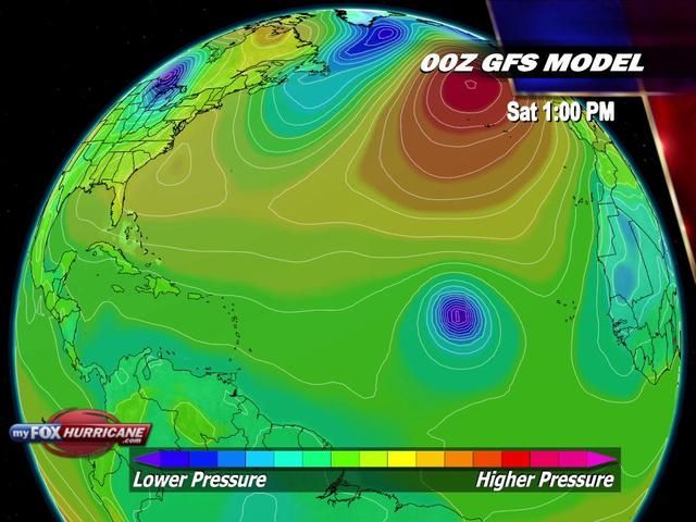
Kaartje voor komende zaterdag.
Dit lijkt dan Igor te gaan worden.
quote:Op maandag 6 september 2010 13:40 schreef meteo-online het volgende:
Tropische storm Hermine ontstaan
Een tropische depressie in het zuidwestelijk gedeelte van de Golf van Mexico is maandag ochtend uitgegroeid tot een tropische storm. De tropische storm is de achtste van het orkaanseizoen van 2010 en heeft de naam Hermine gekregen. Hermine koerst naar de kust van Mexico en de Verenigde Staten en heeft momenteel windsnelheden van 65 kilometer per uur. De tropische storm lag maandagochtend ongeveer 375 kilometer ten zuidoosten van La Pesca, Mexico. De storm verplaatst zich noordwaarts met een snelheid van 13 kilometer per uur. Na alle verwachtingen zal Hermine dinsdagochtend aan land gaan ter hoogte van de noordoost hoek van Mexico of zuidelijke punt van Texas.
Bron: NASA - Hier een satellietopname van de tropische storm Hermine
Volgens het National Hurricane Center kan Hermine in het noordoosten van Mexico en in het zuidwesten van Texas grote hoeveelheden neerslag achter gaan laten die op kunnen lopen tot 200mm, in de afgelegen gebieden kan er zelfs een hoeveelheid van 300mm aan neerslag gaan vallen. Deze hoeveelheden regen kunnen levensbedreigende situaties tot het gevolg hebben. Overstromingen en modderlawines behoren tot de mogelijkheden in de hogere gelegen gebieden van noordoost Mexico. Momenteel is er een tropische storm waarschuwing van kracht voor de kust van Mexico van Tampico naar de Rio Grande en de kust van Zuid-Texas van de Rio Grande naar Baffin Bay.
Bron Weerdirect

Tropical Storm Malou trekt over Zuid Korea en daarna richting Japan.
Malou
[ Bericht 45% gewijzigd door #ANONIEM op 06-09-2010 14:48:35 ]
Malou
[ Bericht 45% gewijzigd door #ANONIEM op 06-09-2010 14:48:35 ]
Zal het nog wat worden met de resten van Gaston? Ik denk het niet. Ben wel benieuwd naar die Igor en de neerslag die Hermine met haar mee zal brengen.
's Avonds een man, overdags rustig an
Gaston komt niet meer tot leven denk ik... depressie... veel regen... maar niets meer dan datquote:TS Hermine will gain strength before hitting Texas
TD 10 became much better organized over night in the southwest Gulf of Mexico and has now become TS Hermine. Top winds are now 45 mph and it is expected to strengthen further, reaching near 60 mph before landfall in northern Mexico. The overall system is large and is spreading rain to the Texas coast this morning. In addition, a tropical storm warning is in effect from Baffin Bay to the mouth of the Rio Grande river. This is the third tropical system to affect the same region this season in the wake of Alex and TD 2. Flooding is going to be a big problem, especially considering the size and overall moisture content of this storm. After landfall, the track shifts back to the east so that it looks as though a big rain event is in store for interior Texas all the way to the coast. Not everyone will receive heavy rain but it looks to be quite a wet week ahead. I will cover this in more detail on today's Weekly Hurricane Outlook video at 2pm ET.
Next storm coming
Off the coast of Africa awaits the next named storm. Conditions are favorable for development out that way as a strong surge of moisture has emerged with a tropical wave. The GFS model in particular, which has been pretty good at tropical storm prediction this season, develops a cyclone out near the Cape Verde Islands this week and moves it westward. Other global models indicate this as well and we are nearing the peak time of the hurricane season, so it makes sense to look at this area for development. .
Flinke wave bij de westkust van Afrika... Zal dit de eerste cat 5 gaan worden? Voorlopig geeft NHC 10% kans op vorming van een TD. Momenteel bestaat het uit veel bewolking en wat onweersbuien


Weer of geen weer, altijd actueel www.onweer-online.nl

Austin, Texas wordt letterlijk onder water gezet door TS Hermine 

quote:Major Flooding in Austin, Texas
Major flooding is occurring in the Austin, Texas region after Tropical Storm Hermine dumped an estimated 10 - 15 inches of rain over the past 24 hours. The flash flood warning for Austin from the National Weather Service at 4am this morning summarized the danger:
"Areas along I-35 and the Balcones Escarpment in and around the Austin Metro area will continue to experience a very dangerous flash flood event over the next few hours. Numerous evacuations and high water rescues have already been reported by the media and law enforcement personnel."
hardest hit was the area ten miles north-northwest of Austin, where an NWS cooperative station measured 10.11" of rain yesterday. The rains have swollen the South Fork of the San Gabriel River at Georgetown, Texas to 50-year flood heights.
Hermine has dissipated, but its heavy rains live on, and are now affecting the Dallas/Fort Worth region, where 1 - 3 inch rainfall amounts have been common. Hermine's rains are still lingering over the hard-hit Austin area, but should remain under one inch for the remainder of the morning. However, this afternoon, additional significant rains are possible near Austin as the sun's heat drives thunderstorm development in the very moist airmass over Central Texas.


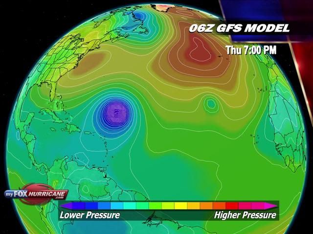
Meteen achter Igor lijkt weer een volgend gebied te ontstaan. Waarschijnlijk gaat dat zaterdag/zondag uitgroeien tot tropische storm.
Zie OP voor kaartje.
Zie OP voor kaartje.
Geloof er niet zo enorm veel in dat het daadwerkelijk een systeem wordt, het zal voornamelijk opgevreten worden door Igor of anders samengevoegd wordenquote:Op woensdag 8 september 2010 22:51 schreef aloa het volgende:
Meteen achter Igor lijkt weer een volgend gebied te ontstaan. Waarschijnlijk gaat dat zaterdag/zondag uitgroeien tot tropische storm.
Zie OP voor kaartje.
Weer of geen weer, altijd actueel www.onweer-online.nl
Nee idd dat gaat niks worden. In het weekend lijkt er weer een nieuwe storm te komen bij de kust van Afrika.quote:Op donderdag 9 september 2010 08:53 schreef meteo-online het volgende:
[..]
Geloof er niet zo enorm veel in dat het daadwerkelijk een systeem wordt, het zal voornamelijk opgevreten worden door Igor of anders samengevoegd worden
Ik las ergens dat Igor ook weer noordwestelijk zal gaan, jammer is dat. Niet dat ik dood en verderf leuk vind, maar het is wel interessant om te zien hoe zo'n orkaan zich ontwikkeld in warmere wateren.
's Avonds een man, overdags rustig an
Van Igor weet ik het zo nog niet. Meestal als een systeem zo snel al een naam krijgt en groeit, dooft hij weer uit voor hij de Amerikaanse kant bereikt. Of het wordt een monsterorkaan, maar die mogelijkheid is een stuk kleiner. Ze volgen elkaar nu wel erg snel op trouwens.
Igor ligt momenteel zo goed als stil :s zal wel weer oplossen net als Gaston
Komt het door het stilstand van de warme golfstroom?
Komt het door het stilstand van de warme golfstroom?
914.000 mensen slachtoffer van stortregens in Mexico
De stortregens in vijf staten in het zuiden en oosten van Mexico treffen 914.000 mensen volgens een balans die de autoriteiten gisteren hebben bekendgemaakt. Zeven mensen zijn om het leven gekomen.
In de staat Veracruz, aan de Golf van Mexico, steeg het aantal slachtoffers van 200.000 tot 500.000, van wie er 16.000 in noodcentra werden opgevangen.
"Nog meer mensen zullen hun toevlucht tot opvangcentra zoeken, want het waterpeil blijft stijgen en de overstroomde zones zullen toenemen, zei de gouverneur van Veracruz", Fidel Herrera, aan de pers. (afp/adv)
hln
quote:Newly-formed Igor is currently a minimal tropical storm, but it is expected to strengthen into a hurricane in the upcoming days.
Tropical Storm Igor is churning less than 100 miles south of the Cape Verde Islands. The AccuWeather.com Hurricane Center has the latest statistics on Igor, including exactly how close the tropical storm is to the islands.
Despite its proximity, residents of the Cape Verde Islands can thank strong winds high in the atmosphere (also known as wind shear) for keeping Igor's impacts minimal on the Cape Verde Islands.
The winds are not only hindering Igor's ability to strengthen into a stronger tropical storm but are also keeping the heaviest rain and tropical storm-force winds west of Igor's center and away from the Cape Verde Islands.
It is possible that the strong wind shear even forces Igor to briefly weaken into a tropical depression at some point today.
A few of Igor's rain squalls could still graze the Cape Verde Islands today, especially the southern and western islands. Rough surf will make swimming and boating for small craft treacherous in the waters surrounding the islands.
Conditions will improve over the Cape Verde Islands on Friday as Igor departs and heads into the open waters of the Atlantic.
The environment over the Atlantic will become more conducive for Igor to intensify than when once-Tropical Storm Gaston passed through. Dry air was an inhibiting factor against Gaston's strengthening, but dry air does not lie in the path of Igor.
After Igor leaves the Cape Verde Islands, the strong wind shear should lessen. That reduction in wind shear, combined with the warm waters of the Atlantic, is why Igor is expected to become a hurricane this weekend.
Igor will not threaten any other land masses for at least a week. However, the AccuWeather.com Hurricane Center will be monitoring the possibility that Igor either takes aim at the Lesser Antilles later next week or gets turned northward by a cold front set to emerge from the East Coast of the United States.
Julia on the Horizon?
Igor may not be the only organized tropical system churning in the Atlantic when this weekend comes to an end.
Current models are hinting that the next strong tropical wave to emerge off the coast of Africa will rapidly strengthen into a named system this weekend, potentially prior to grazing the Cape Verde Islands.
The next tropical storm in the Atlantic Basin would acquire the name "Julia."
Er ligt nu een gebied van 40% bij de benedenwindse eilanden, heeft misschien potentieel voor Julia.
's Avonds een man, overdags rustig an
Ben benieuwd welke Julia wordt.
Kaartje voor Dinsdag laat in ieder geval Igor zien (en Julia en Karl?)
Kaartje voor Dinsdag laat in ieder geval Igor zien (en Julia en Karl?)

Las net dat het voor de eerste keer in de geschiedenis is dat de Kaapverdische Eilanden onder "tropical storm watch" kwamen 
Igor is coming!
Igor is coming!
Hmmz het gaat steeds beter, nog even en NL krijgt er ook 1  alleen dat zullen wij wel niet meer gaan mee maken denk ik
Het orkaan seizoen komt lekker op gang, de 1 na het ander
Het orkaan seizoen komt lekker op gang, de 1 na het ander
<a href="https://www.youtube.com/channel/UCPueUwKfPaGH7v48LZlltkg" rel="nofollow" target="_blank">WSDokkum Youtube</a>
Inderdaad, ligt wat moois klaarquote:Op donderdag 9 september 2010 09:38 schreef aloa het volgende:
[..]
Nee idd dat gaat niks worden. In het weekend lijkt er weer een nieuwe storm te komen bij de kust van Afrika.

Weer of geen weer, altijd actueel www.onweer-online.nl
Ben benieuwd wat Igor gaat doen.
Er zit wel hogedruk, waardoor deze misschien een zuidelijke koers blijft houden.
[ Bericht 0% gewijzigd door #ANONIEM op 11-09-2010 14:16:24 ]
Er zit wel hogedruk, waardoor deze misschien een zuidelijke koers blijft houden.
[ Bericht 0% gewijzigd door #ANONIEM op 11-09-2010 14:16:24 ]
Onderschat orkanen niet hequote:Op zaterdag 11 september 2010 14:15 schreef aloa het volgende:
Ben benieuwd wat Igor gaat doen.
Er zit wel hogedruk, waardoor deze misschien een zuidelijke koers blijft houden.
[ afbeelding ]
Die kunnen trouwens toch gewoon door die hoge druk gaan of de hoge druk verzwakken?
<a href="https://www.youtube.com/channel/UCPueUwKfPaGH7v48LZlltkg" rel="nofollow" target="_blank">WSDokkum Youtube</a>
Julie zal vanavond of vannacht ontstaan....
lijkt te groeien en raakt beter georganiseerd...
kon een gevaar gaan vormen voor oa Jamaica, Yucatan
lijkt te groeien en raakt beter georganiseerd...
kon een gevaar gaan vormen voor oa Jamaica, Yucatan
Igor wordt "major hurricane"
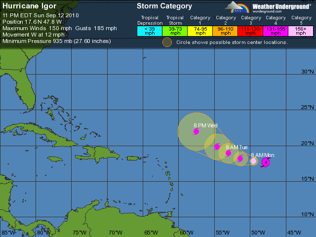
Tropische storm Igor heeft zich versterkt tot een orkaan en zal in de komende dagen uit gaan groeien tot een "major hurricane". De Amerikanen gebruiken die term als wind aanhoudend is tussen de 177 en de 208 kilometer per uur. Igor is de vierde orkaan van het Atlantisch orkaanseizoen 2010 en is momenteel een categorie 1 orkaan. Orkaan Igor ligt momenteel ongeveer 2000 kilometer ten oosten van de Benedenwindse Eilanden en zal met een snelheid van zo'n 27 kilometer per uur naar het westen.
Computermodellen verwachten dat Igor in de Atlantische Oceaan verblijft de komende dagen en niet de Golf van Mexico zal aandoen, waar de Amerikaanse olie-en gas-activiteiten zijn gelegen. Het orkaanseizoen van 2010 zou een actief jaar gaan worden, echter tot nu toe zijn er vier orkanen voorgekomen waarvan twee de status "major hurricane" hebben gekregen. Diverse analisten verwachten dat het orkaanseizoen tenminste 5 "major hurricanes" van categorie 3 of hoger gaan voorkomen.
Bron Weerdirect
Tropische storm Igor heeft zich versterkt tot een orkaan en zal in de komende dagen uit gaan groeien tot een "major hurricane". De Amerikanen gebruiken die term als wind aanhoudend is tussen de 177 en de 208 kilometer per uur. Igor is de vierde orkaan van het Atlantisch orkaanseizoen 2010 en is momenteel een categorie 1 orkaan. Orkaan Igor ligt momenteel ongeveer 2000 kilometer ten oosten van de Benedenwindse Eilanden en zal met een snelheid van zo'n 27 kilometer per uur naar het westen.

Computermodellen verwachten dat Igor in de Atlantische Oceaan verblijft de komende dagen en niet de Golf van Mexico zal aandoen, waar de Amerikaanse olie-en gas-activiteiten zijn gelegen. Het orkaanseizoen van 2010 zou een actief jaar gaan worden, echter tot nu toe zijn er vier orkanen voorgekomen waarvan twee de status "major hurricane" hebben gekregen. Diverse analisten verwachten dat het orkaanseizoen tenminste 5 "major hurricanes" van categorie 3 of hoger gaan voorkomen.
Bron Weerdirect
Weer of geen weer, altijd actueel www.onweer-online.nl
Van Weerwoord:
quote:Vooral Bermuda moet hem in het oog gaan houden volgens GFS. In deze run mist Igor Bermuda op nog geen 50 km...
EC is westelijker, maar voorlopig nog geen echte bedreiging voor de Oostkust.
Hij heeft zelfs al een klein oogje


<a href="https://www.youtube.com/channel/UCPueUwKfPaGH7v48LZlltkg" rel="nofollow" target="_blank">WSDokkum Youtube</a>

Net als Danielle, gaat Igor idd recht op Bermuda af. Nog wel ver weg.quote:
Lijkt er op dat het een categorie 4 gaat worden.


Die kans is klein, kleiner dan 5%. Ik denk dat hij als cat. 3 over Bermuda heenvliegt.
's Avonds een man, overdags rustig an

quote:Hurricane Igor is living up to its name after rapidly intensifying into a monster Category 4 hurricane Sunday afternoon. The storm could easily become the strongest hurricane of the season thus far.
While Igor fortunately poses no threat to land over the next few days, people in Bermuda, Atlantic Canada and along the East Coast of the U.S. should be keeping track of this storm for potential impacts next weekend and beyond.
The AccuWeather.com Hurricane Center reports that Igor's maximum sustained winds were estimated to have increased to 140 mph late Sunday afternoon as the storm headed westward over the south-central Atlantic.
While minor fluctuations in intensity can occur, Igor is generally expected to remain a Category 4 hurricane throughout this upcoming week and could even reach Category 5 status for a time.
Fortunately, the storm is expected to remain out to sea through the end of the week, steering clear of the Leeward Islands as it tracks to the west-northwest. Thereafter, computer models all show Igor making a turn more toward the north over the western Atlantic but differ on how soon that will happen.
Igor's track over warm waters and through weak wind shear (strong winds high up in the atmosphere) should allow the storm to remain a major hurricane throughout the week.
Many of the models are indicating that this northward turn will happen before this upcoming weekend and direct Igor right toward Bermuda.
While this is the more likely scenario, there are still some models hinting that the storm may wait a bit longer to curve northward, passing west of Bermuda and drawing closer to the East Coast of the U.S.
Either scenario could bring Igor dangerously close to Newfoundland and perhaps also Nova Scotia.
The bottom line is that people living in or traveling to Bermuda, Atlantic Canada or the East Coast of the U.S. this weekend or early next week should pay close attention to Igor. At the very least, rough surf and potentially deadly rip currents will be a major concern.
So far this season, Earl has been the strongest hurricane, topping out at Category 4 status with maximum sustained winds of 145 mph. Igor will not have to intensify much further to take Earl's spot at the top.
For more details on the current position, strength and movement of Igor, check out the AccuWeather.com Hurricane Center.

Die kans is aanwezigquote:Op zondag 12 september 2010 21:54 schreef Fredo55 het volgende:
Hoe groot is de kans dat Igor een categorie 5 word?
Igor heeft momenteel een windveld van 225 km/uur met windstoten tot 265 km/uur.
Laagste druk is 942 mb.
Laagste druk is 942 mb.
Als ik naar de 5-daagse verwachting kijk van Igor en dan ook naar de 5-daagse van "Julia" dan komen ze vrijdag eng dicht bij elkaar te liggen. Misschien wordt dit wel de perfecte storm zoals in 1991. Hieronder stukje wikipedia....
Orkaan 8, of De volmaakte storm
Op 28 oktober ontstond er een baroklinisch lagedrukgebied, dus een extra-tropische depressie met fronten systeem, ten oosten van Nova Scotia. Deze depressie trok naar het zuidoosten en bereikte windkracht 8. Daarna draaide de storm naar het zuidwesten en westzuidwesten en won aan kracht, mede doordat het sterke koufront, behorende tot de depressie, orkaan Grace schepte, haar circulatie vernietigde en haar convectie aanzoog. Op 30 oktober bereikte de storm zijn extra-tropische hoogtepunt met windsnelheden tot 110 km/uur en een minimale druk 972 mbar op 600km ten zuiden van Halifax in Nova Scotia. Op dit moment veroorzaakte de storm al veel wind en ruige zeeën aan de Amerikaanse oostkust; er werden golven tot 30 meter gerapporteerd. Daarna draaide de storm bij naar het zuiden en zuidoosten, waardoor de storm boven de Golfstroom schoof. Met zeewatertemperatuur van 26 C, ontwikkelde zich in het centrum van het lagedrukgebied convectie, waardoor het op 31 oktober promoveerde tot subtropische storm. Nu ontstond er snel een tropische storm uit de subtropische storm binnen de kern van het omvangrijke, oorspronkelijke extra-tropische lagedrukgebied. Dit was een zeer opmerkelijke, maar geen unieke situatie.
Nu er een tropische storm was ontstaan binnen deze extra-tropische storm, had die recht op de naam Henri. Omdat de extra-tropische storm de oostkust van de Verenigde Staten al een paar dagen teisterde en verwacht werd, dat de tropische storm niet zou landen, werd besloten de storm geen naam te geven, om verwarring en/of paniek te voorkomen. De tropische storm draaide nu naar het noordoosten en noordnoordoosten en won aan kracht. Later op 1 november promoveerde de tropische storm tot orkaan en bereikte zijn hoogtepunt als tropische cycloon met windsnelheden tot 120 km/uur en een minimale druk 980 mbar. De orkaan trok verder naar het noordnoordoosten en verzwakte gestaag boven koeler water, twaalf uur later degradeerde de orkaan op 2 november tot tropische storm en landde dezelfde dag bij Halifax, Nova Scotia. Ten noorden van Nova Scotia, in de Baai van St. Laurence degradeerde de tropische storm tot tropische depressie, die snel oploste. De orkaan eiste in totaal (in zijn bestaansduur als extra-, subtropisch en tropisch systeem) 13 mensenlevens en veroorzaakte $1,3 miljard aan schade.
De orkaan deed een vissersschip zinken, de Andrea Gail en zes opvarenden verdronken. De orkaan veroorzaakte een hogere vloed van meer dan 4 meter, en een stormvloed van anderhalve meter. Het omvangrijke systeem had een koufront, dat in Minnesota een sneeuwstorm veroorzaakte van drie dagen. In Saint Paul en Minneapolis lag een sneeuwdek van 72 cm. Over de lotgevallen van het schip Andrea Gail en haar opvarenden schreef Sebastian Junger het boek The Perfect Storm, dat werd vertaald in het Nederlands (De volmaakte storm). Dit boek werd in 2000 verfilmd als The perfect storm, met in de regie Wolfgang Petersen en in de hoofdrollen George Clooney, Mark Wahlberg, Diane Lane, Karen Allen en Mary Elizabeth Mastrantonio. De nabestaanden van de opvarenden van de Andrea Gail waren niet ingenomen met de film en besloten naar de rechter te stappen. De zaak werd echter onontvankelijk verklaard, omdat de film viel onder de vrijheid van meningsuiting, beschreven in het Eerste amendement van de grondwet van de Verenigde Staten.
Weer of geen weer, altijd actueel www.onweer-online.nl
Cat 4 inmiddels, vanavond cat.5 ?
Kan me niet herinneren dat een storm zo ver op zee al een Cat.4/5 werd
Maar voor als nog nog geen bedreiging, in de tussentijd dat die aan land komt kan er van alles gebeuren.
<a href="https://www.youtube.com/channel/UCPueUwKfPaGH7v48LZlltkg" rel="nofollow" target="_blank">WSDokkum Youtube</a>
quote:Monster Igor heads for Bermuda
Hurricane Igor is going to boost the ACE index big time. That is the number used to measure the true output of energy from tropical cyclones in a season. The higher the wind speed and the longer those winds stay high, the more energy is output and the higher the ACE value. Igor may take us above 100 if it stays powerful long enough. The good news is that, so far, it is doing its job of bleeding off built-up heat in the tropics without affecting land. Will it remain that way for its entire life-span? Probably so but there are a couple of "what ifs" that need to be looked at.
The NHC track takes Igor on a path that aims it right at the North Carolina coast if nothing changed and it went on a straight line from the five day position forward. But we know this is not the case. Weather is dynamic. Igor may not even get to that forecast point- it could be well east or well west (south too). The big key is once again how much high pressure is to the north of Igor as it continues west. The stronger and firmer the high is, the more west Igor travels. And then comes the critical turn to the northwest. Will it happen? If so, to what degree? It may not be enough to get Igor far enough north to allow it to eventually turn out to sea. We are still talking over a week away. That's 168 hours! So much can change that will affect the outcome of Igor's ulitmate track. I would suggest that folks with interests in Bermuda keep a really close watch on Igor since it is already a powerful hurricane and likely to become a category five before all is said and done. One thing is for sure- the waves from Igor will pound the East Coast, Puerto Rico, Bermuda and eventually the Canadian Maritimes much like hurricane Bill did last year. Surfers will have another shot at some excellent swells coming for the coast. Swimmers will need to be extra careful in the latter part of next week.
Valt nog niks van te zeggen idd. GFS stuurt Igor nu langs de Oostkant van Bermuda. Gister liep de route nog langs het westen van Bermuda. Zoals altijd veranderd de koers steeds weer.
Nu: Windveld van 241 km/uur met windstoten tot bijna 300 km/uur.
Druk in het centrum is 935 mb
[ Bericht 4% gewijzigd door #ANONIEM op 13-09-2010 12:17:15 ]
Nu: Windveld van 241 km/uur met windstoten tot bijna 300 km/uur.
Druk in het centrum is 935 mb
[ Bericht 4% gewijzigd door #ANONIEM op 13-09-2010 12:17:15 ]
Indd, voor je het weet wijkt deze af en krijgt Bermuda er niks van mee.
Maar allemachtig wat een wind zit daar in zeg, stoten stoten bijna 300km/h, dat haal je bijna niet eens hier op de snelwegen
Maar allemachtig wat een wind zit daar in zeg, stoten stoten bijna 300km/h, dat haal je bijna niet eens hier op de snelwegen
<a href="https://www.youtube.com/channel/UCPueUwKfPaGH7v48LZlltkg" rel="nofollow" target="_blank">WSDokkum Youtube</a>
Laura niet in haar ééntje op haar zeilbootjequote:Op maandag 13 september 2010 14:08 schreef _Flea_ het volgende:
Je word er gewoon bang van als je dit ziet.
Dergelijke stormen zal ze niet overleven.quote:Op maandag 13 september 2010 17:09 schreef Co_OL het volgende:
[..]
Laura niet in haar ééntje op haar zeilbootje
Volgens mij wachtte ze het orkaanseizoen af. (slim van haar).
ze had ook gewoon twee maand later kunnen vertrekken en dus nog twee maand naar school gekunt, de bitch
Ze had gewoon haar school moeten afmaken.quote:Op maandag 13 september 2010 19:07 schreef Frutsel het volgende:
ze had ook gewoon twee maand later kunnen vertrekken en dus nog twee maand naar school gekunt, de bitch

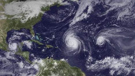
Igor is heel fotogeniek Prachtig exemplaar, helaas zal het net geen cat. 5 worden. Ik ben erg benieuwd of we dit seizoen nog een orkaan in de Golf gaan zien.
's Avonds een man, overdags rustig an

<a href="https://www.youtube.com/channel/UCPueUwKfPaGH7v48LZlltkg" rel="nofollow" target="_blank">WSDokkum Youtube</a>
Dan is het Bermudaaaaaaaaaaaaaagquote:Op dinsdag 14 september 2010 14:55 schreef Co_OL het volgende:
Ze schatten nu nog een CAT2 over Bermuda maar wat als er een CAT4 of 5 overheen gaat :|
quote:Why are the hurricanes not reaching us?
So why are all of these powerful hurricanes not hitting the U.S.? It's simple. The pattern is not one that allows them to. We are lacking a stronger Bermuda High that would normally receive the hand off of westward moving hurricanes from the Azores High. Instead, there is a gaping hole in the western Atlantic steering pattern that allows these hurricanes to slip through like a helium balloon floating up, up and away. This path of curvature out to sea just happens to be far enough off the East Coast to keep cities like Miami, Charleston, Wilmington, New York and Boston all hurricane-free. Will the pattern change? It might, but time is running out for major hurricanes to impact the East Coast without them suffering from shearing winds and gradually cooling sea surface temps. The focus is going to begin to shift, in about 10 days, to the western Atlantic and the Caribbean Sea- very typical of a La Nina pattern. I will show in today's weekly Hurricane Outlook video broadcast what other major La Nina hurricane seasons looked like and how some are heavily weighted on the back end, meaning the last half had more impact than the first half or even the peak period of mid-September.
Ziet er dus naar uit dat we vanaf de laatste week September ook meer gunstige condities krijgen voor orkanen die het vaste land gaan bereikenquote:IGOR POSES NO DIRECT THREAT TO U.S. BUT BERMUDA ON ALERT
Igor
Powerful hurricane Igor has begun to make the turn from its due west course. This has been anticipated and hoped for and is a sign that the hurricane will eventually move north and then northeast away from the United States. The only land mass in its path over the next week is Bermuda. The good news there is that Bermuda is a small island in a big ocean. It would take a precise direct hit to bring severe conditions to the island- not impossible to accomplish but tough none the less.
The only visible effect from Igor along the shores of the western Atlantic land masses will be large swells that have been, and continue to be, generated by the hurricane's wind field. These will arrive in the Caribbean islands soon and eventually along the East Coast of the U.S. and Bermuda by the weekend. Another great surfing period is coming up but people need to remember that rip currents and rough surf can be deadly for those not accustomed to such conditions.
Julia
Julia is now a hurricane and will turn north and on out to sea over the next several days- keeping the string of good luck going of no hurricane landfalls this season outside of Alex in late June.
Changes coming... activity will shift south and west
Beyond the exits of Igor and Julia in the next week or so, it looks as though we will see activity begin to shift south and west with time. Computer models are beginning to indicate the development of tropical cyclones in lower latitudes as the western Atlantic high pressure (Bermuda High) strengthens. While it is too soon to know where such development will occur, it should not be surprising to see a tropical storm or hurricane moving towards the Lesser Antilles within about 10 days. This is very typical of a La Nina pattern where the most active part of the season extends beyond the normal peak time of mid-September. For now, at least, we can track the hurricanes as they travel far away from land.
Volgens NHC moet je de 5-daagse verwachting niet serieus nemen, track fouten kunnen gemakkelijk een paar honderd kilometer ernaast zitten. Het is nog te vroeg om met zekerheid vast te stellen of dat Igor aanzienlijke schade kan aanbrengen op het eiland.quote:Op dinsdag 14 september 2010 14:55 schreef Co_OL het volgende:
Ze schatten nu nog een CAT2 over Bermuda maar wat als er een CAT4 of 5 overheen gaat :|
Weer of geen weer, altijd actueel www.onweer-online.nl
De koers brengt Igor nu aan de westkant van Bermuda. De kant met het zwaarste stormveld zal dan over het eiland trekken.
http://www.accuweather.co(...)ane-on-a-path-to.aspquote:Igor remains a monster Category 4 hurricane on a path that could take it dangerously close to Bermuda this weekend.
People living in or soon traveling to the island should pay close attention to this formidable storm and be ready to take appropriate action.
Through the end of the week, Igor will remain a powerful hurricane over the open waters of the Atlantic, passing well north of the Leeward Islands but still bringing increased waves and swells to the region.
The AccuWeather.com Hurricane Center has more details on the current location, strength and motion of the storm.
While minor fluctuations in strength will occur, Igor is generally expected to remain a Category 4 hurricane over the next day or two. As the storm starts moving over cooler waters and into stronger wind shear (strong winds high up in the atmosphere) toward the weekend, it should start to weaken.
Despite this weakening, Igor will still be a force to be reckoned with. The AccuWeather.com Hurricane Center is forecasting the storm to be a Category 3 or strong Category 2 hurricane with it passing dangerously close to Bermuda Friday night into early Saturday.
Damaging winds, flooding rain, extremely rough surf and a storm surge could all become major problems for the island if Igor passes close enough.
This will be especially true if the eye tracks just to the west of Bermuda, putting the island in the right front quadrant of the storm, where winds are strongest and the storm surge is highest.
Gaat lekker!
Ben benieuwd wat die gaat doen daar.
Ben benieuwd wat die gaat doen daar.
<a href="https://www.youtube.com/channel/UCPueUwKfPaGH7v48LZlltkg" rel="nofollow" target="_blank">WSDokkum Youtube</a>

Ik zag vanavond op het RTL weer een hele mooie loop van dichtbij van Igor.
Net even wezen googelen en dit leverde het op
http://rammb.cira.colosta(...)relative_vis_floater
Net even wezen googelen en dit leverde het op
http://rammb.cira.colosta(...)relative_vis_floater

2 orkanen van categorie 4, waarvan Igor net iets zwaarder is. 233 km/uur met windstoten tot 290 km/uur. De druk in het oog is 935 mb.
Igor koerst nu weer recht op Bermuda af.
Igor koerst nu weer recht op Bermuda af.

Komen nu pas berichten uit NK
quote:Tientallen doden door Kompasu in NoordKorea
In Noord-Korea zijn tientallen mensen omgekomen bij de doortocht van tyfoon Kompasu, meldt het officiële Noord-Koreaanse agentschap KCNA. In Zuid-Korea kwamen al vijf mensen om sinds de tyfoon op 2 september aankwam op het schiereiland.
Volgens KCNA zijn meer dan 8.000 huizen en 230 overheidsgebouwen verwoest. Akkers, wegen, spoorwegen en elektriciteitslijnen werden zwaar toegetakeld. Volgens hulporganisaties zal het stormweer van dit jaar de chronische voedseltekorten in de regio verergeren.
Het Zuid-Koreaanse Rode Kruis kondigde eergisteren aan dat het Noord-Korea hulp wil sturen na de zware overstromingen in augustus. Na maanden van spanning lijken de relaties tussen Noord- en Zuid-Korea opnieuw enigszins te ontdooien
Igor heeft op dit moment een luchtdruk van 925mb
Dit is volgens de laagste hoeveelheid voor een Cat.4 orkaan in de Atlantic in de afgelopen tien jaar.
Hij zit echt net op de grens met een Cat.5 volgens mij
Dit is volgens de laagste hoeveelheid voor een Cat.4 orkaan in de Atlantic in de afgelopen tien jaar.
Hij zit echt net op de grens met een Cat.5 volgens mij
Karl trekt over Mexico heen en zal in de Golf zich nog ontwikkelen tot een orkaan. Om vervolgens weer aan land te gaan in Mexico

quote:Karl doet het rustig aan
Tropische storm Karl is woensdagavond en in de nacht (lokale tijd) het Mexicaanse schiereiland Yucatan gepasseerd, zonder voor grote problemen te zorgen. Dat melden autoriteiten donderdag.
Er moesten enkele honderden mensen geëvacueerd worden door het slechte weer. Ook zaten tienduizenden mensen in vooral plattelandsgebieden zonder stroom door de storm.
Karl kwam met windsnelheden van 90 kilometer per uur aan land, maar verzwakte vrij snel. Meteorologen van het Amerikaanse Orkaancentrum (NHC) verwachten dat Karl, nu hij boven de Golf van Mexico is aangekomen, weer zal winnen aan kracht. Vrijdagavond (lokale tijd) zal Karl als een orkaan de oostkust van Mexico treffen, voorspelt het NHC. De overheid heeft een orkaanwaarschuwing uitgegeven voor dat gebied. Ook kijkt de Mexicaanse oliegigant Pemex met argusogen naar de ontwikkeling van Karl. In de baai van Campeche staan veel boorplatformen, die last kunnen hebben van de storm
Hmmz 90km/h valt indd wel mee, dat hebben we hier in NL ook wel gehad 
Ga me alleen zorgen maken om die boorplatformen, volgens mij gaan we een 2de ramp krijgen...
Ik weet dat ze daarop gebouwd zijn, maar de verhalen tegenwoordig...
Ga me alleen zorgen maken om die boorplatformen, volgens mij gaan we een 2de ramp krijgen...
Ik weet dat ze daarop gebouwd zijn, maar de verhalen tegenwoordig...
<a href="https://www.youtube.com/channel/UCPueUwKfPaGH7v48LZlltkg" rel="nofollow" target="_blank">WSDokkum Youtube</a>
Karl is inmiddels in de golf en heeft orkaankracht bereikt.
Is zelfs op weg om een categorie 2 te worden.
Windsnelheid van 120 km/uur met windstoten tot 144 km/uur.
Kerndruk is 983 mb
Is zelfs op weg om een categorie 2 te worden.
Windsnelheid van 120 km/uur met windstoten tot 144 km/uur.
Kerndruk is 983 mb
Deze mooie jongen is wel lekker actief bezig. Wat een toenamequote:
Karl is inmiddels in de golf en heeft orkaankracht bereikt.
Is zelfs op weg om een categorie 2 te worden.
Windsnelheid van 120 km/uur met windstoten tot 144 km/uur.
Kerndruk is 983 mb
[ afbeelding ]
<a href="https://www.youtube.com/channel/UCPueUwKfPaGH7v48LZlltkg" rel="nofollow" target="_blank">WSDokkum Youtube</a>
Karl groeit tot orkaan en koerst naar Mexico
MIAMI - Tropische storm Karl is uitgegroeid tot een orkaan en zal vrijdagmiddag (lokale tijd) de oostkust van Mexico bereiken. Daarbij zal hij snel aan kracht winnen. Dat meldt het Amerikaanse Orkaancentrum (NHC) donderdag.
Orkaan Karlslideshow De Mexicaanse overheid heeft een orkaanwaarschuwing uitgegeven voor een deel van de oostkust. Karl zal iets ten noorden van de stad Veracruz aan land komen, verwachten meteorologen.
De storm zal dan naar verwachting windsnelheden van 160 tot 180 kilometer per uur bereiken. Lokaal kan de orkaan voor 35 centimeter aan regenval zorgen in de binnenlanden van Mexico.
Beschermen
Het NHC waarschuwt bewoners van de kustregio's om zichzelf en hun bezittingen te beschermen tegen de storm.
Pemex, het Mexicaanse staatsoliebedrijf, houdt de ontwikkeling van Karl nauwlettend in de gaten, maar de schade aan boorplatformen in de Golf van Mexico lijkt mee te vallen.
nu.nl
Ik kan geen meteogrammen vinden die stormwinden aangeeft. Ben altijd wel benieuwd naar de resultaten.
Enige die kan vinden met hoop neerslag maar normale wind:
Poza Rica:
Actueel
[ Bericht 16% gewijzigd door SpeedyGJ op 17-09-2010 10:15:45 ]
Enige die kan vinden met hoop neerslag maar normale wind:
Poza Rica:

Actueel

[ Bericht 16% gewijzigd door SpeedyGJ op 17-09-2010 10:15:45 ]
<a href="https://www.youtube.com/channel/UCPueUwKfPaGH7v48LZlltkg" rel="nofollow" target="_blank">WSDokkum Youtube</a>
Karl wordt zelfs nog cat 3
Gaat hard zeg in zon "klein" stukje
Igor bracht gister golven van 10 tot 11 meter voort 
Gaat hard zeg in zon "klein" stukje
Igor bracht gister golven van 10 tot 11 meter voort
Link aangepast van de actuele stand.
En indd gaat behoorlijk hard, maar als je nu de grafieken kijkt wat is dat nou? Van een waterbom naar heel stuk minder regen, ook komt die later....tja orkanen
Als die golven op de pier komen dan kan ik mijn apparatuur wel uit het hokje gaan halen::') , watte? Dan kan ik beter gaan vluchten naar hoger gelegen gebieden
En indd gaat behoorlijk hard, maar als je nu de grafieken kijkt
Als die golven op de pier komen dan kan ik mijn apparatuur wel uit het hokje gaan halen::') , watte? Dan kan ik beter gaan vluchten naar hoger gelegen gebieden
<a href="https://www.youtube.com/channel/UCPueUwKfPaGH7v48LZlltkg" rel="nofollow" target="_blank">WSDokkum Youtube</a>

Ik ben benieuwd wat Julia gaat doen 
Ik ben illegaal!
Op woensdag 1 december 2010 16:07 schreef honkeytonk het volgende:Ik denk zelfs dat ze achter de schermen een fantopic over mij hebben geopend :Y
Op woensdag 1 december 2010 16:07 schreef honkeytonk het volgende:Ik denk zelfs dat ze achter de schermen een fantopic over mij hebben geopend :Y
Die stelt niks voor vergeleken met haar broer Igor die net naast haar raastquote:Op vrijdag 17 september 2010 10:30 schreef Ploertendoder het volgende:
Ik ben benieuwd wat Julia gaat doen
Hij gaat ter hoogte van Veracruz aan land zie ik, en net iets boven Mexico City langs. Ik wens ze veel sterkte daar
Igor en Julia komen ter hoogte van New York op de Atlantic samen. Kunnen wij over een week of anderhalf nog wel eens flink veel last van krijgen, lekkere depressie zal dat worden.
OMG, een cat. 4 landfall. Dat is slecht nieuws voor die mensen daar! Karl is echt een sluipschutter geworden, vanuit het niets even een cat. 4 worden! Je ziet nu in de satellietbeelden een duidelijk oog, wel mooi om te zien, maar voor de rest...
's Avonds een man, overdags rustig an
Even snel een topic voor Karl gemaakt, want dit wordt een flinke storm
Orkaan Karl gaat Mexico hard treffen
Voor Igor was er ook al eentje
Monsterorkaan Igor (Cat.4) op ramkoers met Bermuda
Orkaan Karl gaat Mexico hard treffen
Voor Igor was er ook al eentje
Monsterorkaan Igor (Cat.4) op ramkoers met Bermuda
Karl is echt groot geworden in een klein tijdsbestek.
Windsnelheid van 194 km/uur en windstoten tot 241 km/uur
Windsnelheid van 194 km/uur en windstoten tot 241 km/uur


Heb je ook plaatsnamen waar die eventueel aan land zou kunnen gaan?
<a href="https://www.youtube.com/channel/UCPueUwKfPaGH7v48LZlltkg" rel="nofollow" target="_blank">WSDokkum Youtube</a>
quote:Op vrijdag 17 september 2010 13:23 schreef SpeedyGJ het volgende:
Heb je ook plaatsnamen waar die eventueel aan land zou kunnen gaan?

Taiwan ligt ook lekker orkaangevoelig zeg. Het Caribische eiland van de Pacific
Bijzonder eigenlijk dat er veel minder aandacht gegeven wordt aan Pacific Hurricanes.
Bijzonder eigenlijk dat er veel minder aandacht gegeven wordt aan Pacific Hurricanes.
Voor als nog gewoon 18m/s op de planning, zal uiteraard nog wel opgevoerd worden.

<a href="https://www.youtube.com/channel/UCPueUwKfPaGH7v48LZlltkg" rel="nofollow" target="_blank">WSDokkum Youtube</a>
Op welke site kun je dit soort beelden vinden?quote:
http://www.opnaardehorizon.blogspot.com, mijn reisblog over 6 maanden Zuidoost-Azië
Deze had ik van een nieuwsite (HLN)quote:Op vrijdag 17 september 2010 14:05 schreef Timm-E het volgende:
[..]
Op welke site kun je dit soort beelden vinden?
maar hier kun je ook beelden vinden.
http://www.fvalk.com/day_image.htm

Check die wind eens toenemen op het laatst 116kt das gewoon 214km/h (als ik het goed heb?).
<a href="https://www.youtube.com/channel/UCPueUwKfPaGH7v48LZlltkg" rel="nofollow" target="_blank">WSDokkum Youtube</a>
Het seizoen is nog niet voorbij.
quote:Hurricanes to Threaten US Late in September, October
While no hurricanes have thus far made landfall on the U.S., forecast weather patterns during the last part of September into October and the first part of November suggest that may be about to change.
AccuWeather.com Hurricane Expert Joe Bastardi is holding firm with his prediction of 18 to 21 named storms in the Atlantic 2010 hurricane season.
Additionally, Joe still expects multiple direct impacts on the U.S.
As the Cape Verde season winds down in October, which is a typical occurrence, the raging La Nina in the Pacific opens the door for warm waters in the Caribbean and the Gulf of Mexico to take center stage.
Changing weather patterns and the approach of cool fronts from northern latitudes would then generate and help steer these tropical storms and hurricanes onto the U.S. coastline in the Gulf, and potentially along the Atlantic Seaboard.
Joe stated that the Cape Verde season typically winds down in October, as prior hurricanes have churned and cooled these waters. At the same time, the Asian Monsoon diminishes, ending the parade of disturbances across Africa and the infamous tropical waves around the Cape Verde Islands.
Breeding grounds during the last third of hurricane season typically migrate toward the Caribbean, Gulf of Mexico, and far western Atlantic because of this.
According to Bastardi, "A switch from an El Nino to La Nina pattern is notorious for a jam-packed late hurricane season."
As a result, people in the coastal U.S., especially along the Gulf of Mexico, should not let their guard down.
Joe asserts, "There is an imbalance in the atmosphere, and much more energy has yet to be released."
Incidentally, at least one computer model insists a potent hurricane will form in the western Caribbean or the southern Gulf of Mexico before the end of September.


Even in het Nederlandsquote:
Orkanen kunnen ook in september en oktober de VS teisteren
Terwijl er momenteel nog geen zware orkanen aan land zijn gekomen in de VS, zal dit volgens de voorspellingen in het laatste deel van september en begin oktober gaan veranderen. AccuWeather.com orkaan expert Joe Bastardi houdt stevig vast aan zijn voorspelling, dat in dit seizoen in de Atlantische oceaan 18 tot 21 orkanen cq tropische systemen met een naam, zullen voorkomen. Bovendien voorspelt Joe meerdere impacts van orkanen op het vasteland van VS.
Als het storm seizoen vanuit Kaapverdië in oktober ten einde komt, wat een normale gebeurtenis is, zet de razende La Nina in de Pacific de deur open voor het warme water vanuit de Caribische zee en vanuit de Golf van Mexico. De veranderende weerpatronen en de aanstormde koufronten vanuit het noorden zullen de tropische stormen en orkanen helpen ontstaan en zelfs nog verder opporren. De tropische systemen zullen naar de kustlijn in de Golf van Mexico en vermoedelijk langs de hele Atlantische kustlijn geduwd worden. Joe verklaart, dat de typische winden rond het Kaapverdische eilanden normaal in oktober luwen doordat eerdere orkanen de wateren rond de eilanden hebben rondgedraaid en afgekoeld. Tegelijkertijd vermindert de Aziatische moesson, waarmee een einde komt aan verstoringen boven Afrika en gaan de beroemde hoge golven rond de Kaapverdische eilanden liggen. De broedplaats voor de orkanen verplaatst hierdoor in het laatste derde gedeelte van het orkaanseizoen naar de Caribische zee, de golf van Mexico en het westelijke gedeelte van de Atlantische oceaan.
Volgens Bastardi is de verandering van El Nino naar La Nina berucht voor een druk cq verlaat orkaanseizoen. Als gevolg hiervan moeten de mensen aan de kust van de VS en vooral in de Golf van Mexico op hun hoede blijven. Er is, volgens Joe, een instabiliteit in de atmosfeer en veel energie hiervan moet nog vrijkomen. Tenslotte geeft het hieronder getoonde computermodel aan, dat een potentiële orkaan zich nog voor het einde van september zal vormen in de westelijke Caribische zee of in het zuidelijke gedeelte van de Golf van Mexico.
Bron onweer-online.nl
Weer of geen weer, altijd actueel www.onweer-online.nl
Er is alweer een 10% area bij. Ligt zuidelijker dan de vorige orkanen, dus ik geef deze wel een kans van slagen wat betreft de Golf van Mexico. Maar dat duurt nog wel 2 weken.
's Avonds een man, overdags rustig an
Doden in Mexico door orkaan Karl
Orkaan Karl is boven het zuiden van Mexico zo sterk afgezwakt, dat het een tropische storm is geworden. Hevige regen veroorzaakt wel overstromingen en aardverschuivingen in het gebied.
In de staat Puebla, ten oosten van Mexico-Stad, vielen twee doden, toen een huis werd bedolven onder een modderstroom.
Karl ontstond ongeveer een week geleden in de buurt van Venezuela. Woensdag trok de tropische storm over het Mexicaanse schiereiland Yucatan. Daarna zwol Karl boven het warme water van de Golf van Mexico aan tot orkaankracht.
Bron
Ik ben illegaal!
Op woensdag 1 december 2010 16:07 schreef honkeytonk het volgende:Ik denk zelfs dat ze achter de schermen een fantopic over mij hebben geopend :Y
Op woensdag 1 december 2010 16:07 schreef honkeytonk het volgende:Ik denk zelfs dat ze achter de schermen een fantopic over mij hebben geopend :Y
Taiwan krijgt ook een voltreffer. Typhoon FANAPI is nu een cat 3.
Windsnelheid van 193 km.uur met windstoten tot 221 km.uur.
Windsnelheid van 193 km.uur met windstoten tot 221 km.uur.
Bermuda:
Ik heb zulke vaantjes nog nooit gezien.
Tussen 22 - 00 staat 33m/s. Tussen 00 - 02 weet ik nog niet, maar dat zal rond de 36m/s zijn.

Ik heb zulke vaantjes nog nooit gezien.
Tussen 22 - 00 staat 33m/s. Tussen 00 - 02 weet ik nog niet, maar dat zal rond de 36m/s zijn.
<a href="https://www.youtube.com/channel/UCPueUwKfPaGH7v48LZlltkg" rel="nofollow" target="_blank">WSDokkum Youtube</a>
Het gebied voor de kust van Afrika is nu 60%, dus dat zal vast wel een nieuwe orkaan worden. Ben benieuwd of die nou eens een zuidelijkere koers zal gaan aanhouden. Achter het 60%-gebied ligt nog een groot complex klaar, dus het wordt weer druk de komende 2 weken.
En Igor stelt trouwens ook niet veel meer voor afgezien van de regenval.
En Igor stelt trouwens ook niet veel meer voor afgezien van de regenval.
's Avonds een man, overdags rustig an
Zeer zware storm tot orkaan kracht. Live stream
Ergens bij de baai
edit:
[ Bericht 15% gewijzigd door SpeedyGJ op 20-09-2010 00:01:11 ]
Ergens bij de baai
edit:
quote:Bermuda, eastern side of the island. this cam is towards west end
[ Bericht 15% gewijzigd door SpeedyGJ op 20-09-2010 00:01:11 ]
<a href="https://www.youtube.com/channel/UCPueUwKfPaGH7v48LZlltkg" rel="nofollow" target="_blank">WSDokkum Youtube</a>
Normaal gezien maken al die KaapVerde orkanen een nette draai naar het noorden; zuidelijker dan de route St. Maarten - Haiti - Cuba - Texas doen ze niet heel vaak. Veel van de orkanen die Yucatan etc. bedreigen ontstaan in de caraiben.quote:
Het gebied voor de kust van Afrika is nu 60%, dus dat zal vast wel een nieuwe orkaan worden. Ben benieuwd of die nou eens een zuidelijkere koers zal gaan aanhouden. Achter het 60%-gebied ligt nog een groot complex klaar, dus het wordt weer druk de komende 2 weken.
En Igor stelt trouwens ook niet veel meer voor afgezien van de regenval.
Zou best kunnen!quote:
[ afbeelding ]
Komt dit voort uit de resten van Orkaan Karl?
Dat betekent dus dat die misschien voor de 3de keer gaat activeren? Zal waarschijnlijk wel geen orkaan meer worden maar toch
<a href="https://www.youtube.com/channel/UCPueUwKfPaGH7v48LZlltkg" rel="nofollow" target="_blank">WSDokkum Youtube</a>
Er lijkt deze week ook nog een storm te ontstaan in de Caribische zee. De Golf lijkt voorlopig rustig.

Ik lees net op Accuweather dat dat inderdaad gaat gebeuren. En die orkaan zal de V.S. ook gaan bereiken. Begin oktober staat dat gepland.quote:Op maandag 20 september 2010 15:35 schreef aloa het volgende:
Er lijkt deze week ook nog een storm te ontstaan in de Caribische zee. De Golf lijkt voorlopig rustig.
's Avonds een man, overdags rustig an
Deze week lijkt er ook al een te ontstaan, die trekt dan over Nicaraqua en Honduras.quote:Op maandag 20 september 2010 19:06 schreef Burnie88 het volgende:
[..]
Ik lees net op Accuweather dat dat inderdaad gaat gebeuren. En die orkaan zal de V.S. ook gaan bereiken. Begin oktober staat dat gepland.
Afwachten maar.
10% voor het gebied bij de Windward Islandsquote:
[..]
Deze week lijkt er ook al een te ontstaan, die trekt dan over Nicaraqua en Honduras.
Afwachten maar.
Die zou wel eens het zelfde kunnen gaan doen als Karl.quote:Op dinsdag 21 september 2010 11:44 schreef Frutsel het volgende:
[..]
10% voor het gebied bij de Windward Islands
Weer of geen weer, altijd actueel www.onweer-online.nl

Ben benieuwd naar dat gebied in de Carraïben.. Lisa gaat niets worden, die wordt tegengehouden door hogedrukgebieden lijkt het wel.
's Avonds een man, overdags rustig an
Tropische Storm Lisa ontstaan
Orkaan Igor is de afgelopen uren duidelijk zwakker geworden en nog net een klasse-1-orkaan met windsnelheden tot 120 km/u. De storm zal de komende uren zijn tropische eigenschappen verliezen en tot een gewone stormdepressie transformeren, die rakelings langs de Canadese oostkust trekt. Canada heeft voorzorgsmaatregelen getroffen en waarschuwingen uitstaan, maar veel schade wordt er niet verwacht, omdat de storm snel aan het afzwakken is.
Tropische storm Lisa ontstaan
Ondertussen is de volgende tropische storm alweer ontstaan die van het National Hurricane Center (NHC) de naam "Lisa" gekregen heeft. Lisa is de twaalfde tropische storm op de Atlantische Oceaan dit jaar. De storm zal zich de komende dagen over warm water en met weinig schadelijke windschering verder kunnen versterken en mogelijk binnen enkele dagen orkaanstatus bereiken. De baan van de storm is momenteel noordelijk en de verdere trekrichting nog erg onzeker omdat Lisa in een windzwakke omgeving ontstaan is, maar veel modellen berekenen dat het systeem over enkele dagen met de passaatwinden naar het westen zal trekken, zoals de meeste tropische stormen die in dit gebied ontstaan.
Het orkanenseizoen 2010 is inmiddels goed bezig om de meeste tropische stormen sinds het recordseizoen 2005 te produceren. Met Lisa zijn er tot nu toe 12 tropische stormen ontstaan en het seizoen zal nog tot 30 november duren. Het NHC had al begin dit jaar voor een buitengewoon actief orkanenseizoen gewaarschuwd, volgens hun zouden 15-18 tropische stormen kunnen ontstaan waarvan er vier tot een major hurricane (klasse 3 of hoger met windsnelheden van minimaal 111 mph of 180 km/u) zouden uit kunnen groeien. Met Danielle, Earl, Igor, Julia en Karl zijn er inmiddels al 5 orkanen die daadwerkelijk "major hurricane"-status bereikt hebben en het is goed mogelijk dat er nog eentje zal ontstaan die tot een major hurricane uit kan gaan groeien.
Orkaan Igor was tot nu toe het sterkste systeem van het orkanenseizoen met windsnelheden tot 250 km per uur en een luchtdruk van 929 hpa. Bovendien had de storm een prachtige, bijna perfecte wolkenstructuur en was dus erg fotogeniek.
Het valt op dat de meeste stormen tot nu toe in het gebied van de Kaapverdische Eilanden zijn ontstaan en ruim buiten het bereik van land gebleven zijn. Uitzonderingen zijn de Orkanen Alex en Karl, die in de Caribische Zee zijn ontstaan en de oostkust van Mexico bereikten, en de tropische stormen Bonnie en Hermine. De Amerikanen hebben tot nu toe veel geluk gehad, alleen major hurricane Earl schampte de oostkust maar bleef met zijn centrum over water, de schade viel uiteindelijk erg mee. Dit is een duidelijk afwijking van de verwachtingen van het NHC, die eerder dit jaar een hoge "landfall"-kans van 70% voorspeld hadden.
Bron Weerdirect
Orkaan Igor is de afgelopen uren duidelijk zwakker geworden en nog net een klasse-1-orkaan met windsnelheden tot 120 km/u. De storm zal de komende uren zijn tropische eigenschappen verliezen en tot een gewone stormdepressie transformeren, die rakelings langs de Canadese oostkust trekt. Canada heeft voorzorgsmaatregelen getroffen en waarschuwingen uitstaan, maar veel schade wordt er niet verwacht, omdat de storm snel aan het afzwakken is.

Tropische storm Lisa ontstaan
Ondertussen is de volgende tropische storm alweer ontstaan die van het National Hurricane Center (NHC) de naam "Lisa" gekregen heeft. Lisa is de twaalfde tropische storm op de Atlantische Oceaan dit jaar. De storm zal zich de komende dagen over warm water en met weinig schadelijke windschering verder kunnen versterken en mogelijk binnen enkele dagen orkaanstatus bereiken. De baan van de storm is momenteel noordelijk en de verdere trekrichting nog erg onzeker omdat Lisa in een windzwakke omgeving ontstaan is, maar veel modellen berekenen dat het systeem over enkele dagen met de passaatwinden naar het westen zal trekken, zoals de meeste tropische stormen die in dit gebied ontstaan.

Het orkanenseizoen 2010 is inmiddels goed bezig om de meeste tropische stormen sinds het recordseizoen 2005 te produceren. Met Lisa zijn er tot nu toe 12 tropische stormen ontstaan en het seizoen zal nog tot 30 november duren. Het NHC had al begin dit jaar voor een buitengewoon actief orkanenseizoen gewaarschuwd, volgens hun zouden 15-18 tropische stormen kunnen ontstaan waarvan er vier tot een major hurricane (klasse 3 of hoger met windsnelheden van minimaal 111 mph of 180 km/u) zouden uit kunnen groeien. Met Danielle, Earl, Igor, Julia en Karl zijn er inmiddels al 5 orkanen die daadwerkelijk "major hurricane"-status bereikt hebben en het is goed mogelijk dat er nog eentje zal ontstaan die tot een major hurricane uit kan gaan groeien.

Orkaan Igor was tot nu toe het sterkste systeem van het orkanenseizoen met windsnelheden tot 250 km per uur en een luchtdruk van 929 hpa. Bovendien had de storm een prachtige, bijna perfecte wolkenstructuur en was dus erg fotogeniek.
Het valt op dat de meeste stormen tot nu toe in het gebied van de Kaapverdische Eilanden zijn ontstaan en ruim buiten het bereik van land gebleven zijn. Uitzonderingen zijn de Orkanen Alex en Karl, die in de Caribische Zee zijn ontstaan en de oostkust van Mexico bereikten, en de tropische stormen Bonnie en Hermine. De Amerikanen hebben tot nu toe veel geluk gehad, alleen major hurricane Earl schampte de oostkust maar bleef met zijn centrum over water, de schade viel uiteindelijk erg mee. Dit is een duidelijk afwijking van de verwachtingen van het NHC, die eerder dit jaar een hoge "landfall"-kans van 70% voorspeld hadden.

Bron Weerdirect
Weer of geen weer, altijd actueel www.onweer-online.nl
Ik ben ook benieuwd naar dat gebied. Kans is aanwezig dat deze Nicaraqua en Honduras overtrekt om vervolgens in de Caribische zee weer aan kracht te winnen.quote:Op dinsdag 21 september 2010 13:39 schreef Burnie88 het volgende:
Ben benieuwd naar dat gebied in de Carraïben.. Lisa gaat niets worden, die wordt tegengehouden door hogedrukgebieden lijkt het wel.
Is nog ver weg natuurlijk. De naam na Lisa is Matthew
bronquote:Igor is trouwens nog steeds flink actief. Nog steeds razen er orkaanwinden rond het centrum en New Foundland krijgt daar een flinke veeg van mee. Zelfs als het centrum van Igor New Foundland is gepasseerd en op rond 60 graden noorderbreedte is aangekomen, wordt Igor nog op orkaansterkte gezet en pas daarna, als hij verder naar het noordwesten koerst, neemt de windsterkte af. Hoe dan ook, het moge duidelijk zijn dat Igor op zeer grote afstand van Europa blijft.
20% nuquote:
Ben benieuwd naar dat gebied in de Carraïben.. Lisa gaat niets worden, die wordt tegengehouden door hogedrukgebieden lijkt het wel.
In navolging van het reeds eerder gemeldde bericht dat de condities voor meer 'westerse' stormen gunstiger worden.
eind september en oktober dus wel degelijk kans op een "major" storm die idd wel landfall gaat maken ergens daarquote:The main concern is going to be the Caribbean Sea. I have been talking about the pattern change coming up and it is almost upon us. Most of the major computer models indicate the formation of a tropical cyclone in the western Caribbean over the course of the next week or less. Right now, the NHC has an area outlined just entering the eastern Caribbean. It should migrate westward and be situated in the western to northwestern Caribbean by the end of the week. At that point, development is likely to begin ramping up as conditions appear quite favorable going out in time. In fact, water temps in the western Caribbean are the warmest anywhere in the Atlantic Basin with extremely high ocean heat content. I need not remind you of the intense hurricanes that have come out of the northwest Caribbean over the course of history. We will need to keep a close eye on what goes on in this region from here on out as I suspect that a significant threat to land masses is in order. It is too soon to know if that threat includes Florida or elsewhere along the Gulf Coast. Right now, Jamaica, the Caymans and the Greater Antilles would be at risk from possible heavy rains and perhaps more as this system begins to organize.
En inmiddels 50% in de Carraïben. De Nederlandse Antillen worden momenteel geteisterd door hevige regenval en windstoten.
's Avonds een man, overdags rustig an
Zo te zien is landfall op Groenland toch nog mogelijk dit jaar 
Een collega van me voer in april langs de kaap verde/over de evenaar, en wist te melden dat het daar toen al over de 30C was, extreem warm. Dus gebaseerd op die waarneming verbaast het me niet heel erg.
Dat gedeelte van orkaan theorie heb ik niet goed in mijn hoofd, maar ik kan me voorstellen dat de KVstormen door hun stormtrack de Carraiben minder open stellen voor orkaanformatie, maar dat die dus nu aan de beurt zijn, aangezien de oceaan zo langzamerhand is leeggezogen.
60% inmiddels. Matthew lijkt daar te ontstaan... en dan zijn vermoedelijk Nicaragua, Honduras aan de beurt.
Afwachten wat er daarna gebeurd... kan zijn dat de storm in die gebieden uitdooft, maar iets noordelijker en hij kan zo weer opnieuw beginnen
Afwachten wat er daarna gebeurd... kan zijn dat de storm in die gebieden uitdooft, maar iets noordelijker en hij kan zo weer opnieuw beginnen
Kans is groot dat Matthew daar ontstaat en volgens GFS kan het ook een grote worden. De andere modellen laten dat ook zien. Kans is aanwezig dat deze de golf in duikt.


In Amerika hebben ze het al over Troptober.
An expected westward shift in the formation of tropical storms or hurricanes to the waters of the Caribbean and the southeastern U.S. could set the stage for tropical troubles during October. Hence, the nickname "Troptober."
The 14-day period beginning in late September into mid-October could yield three to five named systems in these waters.
The amount of disruptions to travel and oil/gas production, as well as flooding, damage and risk to human lives caused by these storms would depend on their strength and exact location.
The tropics may make up for lost time in terms of direct impacts from tropical storms and/or hurricanes on the U.S., as the nearby waters of the Gulf of Mexico, Caribbean and the southwestern Atlantic are primed to explode during October.
October may be the month the southeastern U.S. is battered by multiple tropical storms or hurricanes.
AccuWeather.com Hurricane Expert Joe Bastardi remains very concerned that the raging La Niña and its associated cool waters in the tropical Pacific have created a tremendous imbalance.
That imbalance must be dealt with via tropical cyclones in the southwest part of the Atlantic Basin where warm waters have led to a buildup of heat.
Factoring in climatology, tropical activity shifts to the far western Atlantic during October with the decline of the Cape Verde season.
Now computer models seem to be rallying to support Joe's concern with a barrage of tropical cyclones appearing to form in succession over the Caribbean and the southwestern Atlantic during the last few days of September through the first part in October.
The GFS and other models are suggesting multiple tropical cyclones will fire in the Caribbean and southwest Atlantic waters over then next few weeks. This image is the GFS forecast for Oct. 5, 2010.
If these models are right, Florida, part of the Gulf Coast, the southern Atlantic Seaboard, Cuba, Hispaniola, Puerto Rico and the Bahamas could be in for multiple rounds of heavy rains, gusty winds, rough seas and battering surf.
The combination of La Nina, climatology and the computer models should have interests keeping a very close eye on the situation in the Southwest Atlantic Basin.
Our first tropical system in this series is likely to take shape by early next week in the Caribbean.
[ Bericht 89% gewijzigd door #ANONIEM op 22-09-2010 20:17:54 ]
An expected westward shift in the formation of tropical storms or hurricanes to the waters of the Caribbean and the southeastern U.S. could set the stage for tropical troubles during October. Hence, the nickname "Troptober."
The 14-day period beginning in late September into mid-October could yield three to five named systems in these waters.
The amount of disruptions to travel and oil/gas production, as well as flooding, damage and risk to human lives caused by these storms would depend on their strength and exact location.
The tropics may make up for lost time in terms of direct impacts from tropical storms and/or hurricanes on the U.S., as the nearby waters of the Gulf of Mexico, Caribbean and the southwestern Atlantic are primed to explode during October.
October may be the month the southeastern U.S. is battered by multiple tropical storms or hurricanes.
AccuWeather.com Hurricane Expert Joe Bastardi remains very concerned that the raging La Niña and its associated cool waters in the tropical Pacific have created a tremendous imbalance.

That imbalance must be dealt with via tropical cyclones in the southwest part of the Atlantic Basin where warm waters have led to a buildup of heat.
Factoring in climatology, tropical activity shifts to the far western Atlantic during October with the decline of the Cape Verde season.
Now computer models seem to be rallying to support Joe's concern with a barrage of tropical cyclones appearing to form in succession over the Caribbean and the southwestern Atlantic during the last few days of September through the first part in October.

The GFS and other models are suggesting multiple tropical cyclones will fire in the Caribbean and southwest Atlantic waters over then next few weeks. This image is the GFS forecast for Oct. 5, 2010.
If these models are right, Florida, part of the Gulf Coast, the southern Atlantic Seaboard, Cuba, Hispaniola, Puerto Rico and the Bahamas could be in for multiple rounds of heavy rains, gusty winds, rough seas and battering surf.
The combination of La Nina, climatology and the computer models should have interests keeping a very close eye on the situation in the Southwest Atlantic Basin.
Our first tropical system in this series is likely to take shape by early next week in the Caribbean.
[ Bericht 89% gewijzigd door #ANONIEM op 22-09-2010 20:17:54 ]
Lisa is gedegradeerd to Tropische Depressie. Gebied in de Caribische zee is nog steeds 60%, maar zal nog verhoogd worden is de verwachting.
quote:An area of low pressure over the south central Caribbean may develop into Matthew over the next couple of days as conditions become more favorable for development.
Too much dry air and too much wind shear have been in place for the low to become better organized so far; however, wind shear is weakening as the low moves over very warm water of the Caribbean.
The system could organize into a depression later today and a tropical storm by Saturday.
Whether the system develops or not, it will target Central America with potentially flooding rainfall over the weekend.
The track of the system is still uncertain after it unleashes torrential rainfall over portions of Nicaragua, Honduras, Guatemala, Belize and southeastern Mexico.
Two different scenarios are that the system will keep moving westward from the Gulf of Honduras into next week or it will first stall then move northward in the Caribbean.
More models are pointing to a conclusion that the system will move northward, over Cuba. This puts Florida at risk for a direct impact from the storm by the middle of next week.
Keep checking back with AccuWeather.com for more information on the potential development of this low into Matthew.
More systems are also likely to form in the Caribbean and the southwestern Atlantic over the next couple of weeks.

Volgens GFS blijft Matthew hangen ter hoogte van Honduras-Mexico om vervolgens via Cuba de Golf in te duiken.

Matthew kan een hele gevaarlijke orkaan worden. Hij zal eerst in Honduras/Belize/Mexico voor veel (water)overlast zorgen. Als hij daarna inderdaad de Golf induikt en afstevent op de kust van de V.S. is het feest compleet. Een dikke cat. 4 of maybe 5 hurricane die landfall zal maken. We zagen al aan Karl dat de Golf enorm veel energie opwekt, dus Matthew zal daar ook enorm aan kracht winnen. Ben benieuwd wat het gaat worden, goed in de gaten houden de komende dagen!
's Avonds een man, overdags rustig an
Als hij het pad blijft volgen zoals op bovenstaand kaartje, is niet de VS aan de beurt, maar Cuba. Hoe dan ook, als hij in de golf terechtkomt en daar een dag of 2 blijft hangen, vrees ik ook dat dit een desastreuze orkaan gaat worden.
Matthew gevaar voor Florida?
In het zeegebied tussen de Bovenwindse Eilanden en het Schiereiland Yucatan is de volgende Tropische storm ontstaan, die van het NHC de naam "Matthew" gekregen heeft. Matthew is de 13de tropische storm van het orkaanseizoen 2010 in de Atlantische Oceaan en een van de weinigen die in de Carribean ontstaan is, de meeste tropische storingen hadden tot nu toe de voorkeur voor het zeegebied ten westen van de Kaapverdische Eilanden. Matthew gaat het Schiereiland Yucatan treffen en heeft mogelijk nog net de tijd om een orkaan te worden, maar zal daarna over land weer snel gaan afzwakken. De treksnelheid van de tropische storm zal over land zeer langzaam zijn wat Matthew tot een zeer gevaarlijke storm maakt, vooral vanwege de enorme regenhoeveelheden die enorme overstromingen kunnen veroorzaken.
Matthew daarna naar het noorden?
Wat Matthew na de landfall op Yucatan gaat doen is onzeker, veel modellen verwachten dat de restanten van het systeem weer de oceaan optrekken, waar Matthew weer aan kracht zou kunnen winnen en een draai naar het noorden zou kunnen maken. De storm zou dan de tijd krijgen om over de zeer warme wateren van de Golf van Mexico duidelijk sterker te worden en het is goed mogelijk dat Matthew dan als orkaan een groot gevaar gaat vormen voor Florida. Het is echter nog niet zeker of de storm de landfall op Yucatan gaat overleven; WeerDirect houdt u natuurlijk over alle ontwikkelingen op de hoogte.
WeerDirect
In het zeegebied tussen de Bovenwindse Eilanden en het Schiereiland Yucatan is de volgende Tropische storm ontstaan, die van het NHC de naam "Matthew" gekregen heeft. Matthew is de 13de tropische storm van het orkaanseizoen 2010 in de Atlantische Oceaan en een van de weinigen die in de Carribean ontstaan is, de meeste tropische storingen hadden tot nu toe de voorkeur voor het zeegebied ten westen van de Kaapverdische Eilanden. Matthew gaat het Schiereiland Yucatan treffen en heeft mogelijk nog net de tijd om een orkaan te worden, maar zal daarna over land weer snel gaan afzwakken. De treksnelheid van de tropische storm zal over land zeer langzaam zijn wat Matthew tot een zeer gevaarlijke storm maakt, vooral vanwege de enorme regenhoeveelheden die enorme overstromingen kunnen veroorzaken.

Matthew daarna naar het noorden?
Wat Matthew na de landfall op Yucatan gaat doen is onzeker, veel modellen verwachten dat de restanten van het systeem weer de oceaan optrekken, waar Matthew weer aan kracht zou kunnen winnen en een draai naar het noorden zou kunnen maken. De storm zou dan de tijd krijgen om over de zeer warme wateren van de Golf van Mexico duidelijk sterker te worden en het is goed mogelijk dat Matthew dan als orkaan een groot gevaar gaat vormen voor Florida. Het is echter nog niet zeker of de storm de landfall op Yucatan gaat overleven; WeerDirect houdt u natuurlijk over alle ontwikkelingen op de hoogte.

WeerDirect
Weer of geen weer, altijd actueel www.onweer-online.nl
Kan volgens mij echt alle kanten op... hij kan afzwakken en uitdoven achter Honduras, maar kan ook maar zo toenemen, afbuigen en opnieuw elders aan land gaan als flinke orkaan
Met een dag of vijf komt er achter Matthew nog een nieuwe storm aan
Met een dag of vijf komt er achter Matthew nog een nieuwe storm aan
NHC verwacht dat de storm verdwenen zal zijn voor 36% volgende week dinsdag. Dus het wordt spannend. Ik kan me trouwens niet herinneren dat een storm noordwaarts over de Golf heentrok.
's Avonds een man, overdags rustig an
Ben blij dat ik daar niet woon. Hoewel het me wel boeiend lijkt om een keer mee te maken (uiteraard zonder letsel ).
Je bent je leven daar gewoon niet zeker in de zomermaanden.
Je bent je leven daar gewoon niet zeker in de zomermaanden.
Is vaker gebeurd. Wilma 2005 b.v.quote:Op vrijdag 24 september 2010 11:52 schreef Burnie88 het volgende:
NHC verwacht dat de storm verdwenen zal zijn voor 36% volgende week dinsdag. Dus het wordt spannend. Ik kan me trouwens niet herinneren dat een storm noordwaarts over de Golf heentrok.

Helaas, Matthew zal verdwijnen na volgende week dinsdag/woensdag. Maar bovenstaand plaatje geeft dus een nieuw systeem aan, welke naam krijgt die? Ziet er wel heftig uit trouwens!
's Avonds een man, overdags rustig an
Er gaat nog wel wat gebeuren
bron: accuweatherquote:Different Scenarios with Matthew into next Week
There are still different scenarios with Matthew into early next week.
One scenario is that Matthew stalls over Central America and gets torn apart into a remnant low due to friction while being over land.
Another scenario is that Matthew could still turn to the north and head in Florida's direction. Whether it does or not, more tropical moisture will be pulled toward the East late this weekend into next week.
Other tropical disturbances will move into the Caribbean through next week, and these could strengthen and become named tropical systems.
It seems most likely that a disturbance that follows Matthew will be the one that ends up heading farther north toward Cuba and Florida next week.
Mmmm naar Florida, toch nog niet zo'n gek bericht van vanmiddag Als Matthew een pinhole eye krijgt (dit is een zeer smal oog en een indicator voor extreme intensivering.) net zoals Karl en niet te vergeten Wilma in 2005 dan kan het nog best een flinke orkaan worden die in een dag cq 1.5 dag uit kan groeien tot major hurricane
Weer of geen weer, altijd actueel www.onweer-online.nl
Zullen we een chase houden met zijn allen?
<a href="https://www.youtube.com/channel/UCPueUwKfPaGH7v48LZlltkg" rel="nofollow" target="_blank">WSDokkum Youtube</a>
Zie de OP. Gilbert met ook een heel smal oog.quote:Op vrijdag 24 september 2010 21:01 schreef meteo-online het volgende:
Mmmm naar Florida, toch nog niet zo'n gek bericht van vanmiddag
Als fok goes Japanese, kunnen we ook fok goes HurricaneChase?quote:
Zullen we een chase houden met zijn allen?
Prima idee voor volgend jaarquote:
[..]
Als fok goes Japanese, kunnen we ook fok goes HurricaneChase?
<a href="https://www.youtube.com/channel/UCPueUwKfPaGH7v48LZlltkg" rel="nofollow" target="_blank">WSDokkum Youtube</a>

quote:Tropische storm komt aan in Centaal-Amerika
AMSTERDAM – Tropische Storm Matthew is vrijdagmiddag (lokale tijd) aan land gekomen in het oosten van Nicaragua. De storm zal naar verwachting voor overstromingen en aardverschuivingen zorgen in Nicaragua, Honduras, Belize en Guatemala.
Dat melden het Amerikaanse Hurricane Centre en AccuWeather.
In Honduras, Guatemala en Belize wordt zo’n tien tot twintig centimeter regen verwacht in korte tijd. Lokaal kan zelfs meer dan dertig centimeter neerslag vallen. Later zal de storm het binnenland van Guatemala intrekken.
Aardverschuivingen
Naast eventuele overstromingen kan Matthew ook zorgen voor aardverschuivingen die volgens Amerikaanse bronnen ‘levensgevaarlijk’ kunnen zijn. Er worden bovendien windsnelheden van zo’n honderd kilometer per uur verwacht.
Nicaragua heeft in verband met de tropische storm meer dan 10.000 mensen geëvacueerd. Honduras heeft preventief de staat van paraatheid uitgeroepen en heeft tevens mensen geëvacueerd uit een aantal kustplaatsjes.
Later in of zelfs na het weekend zal de storm Mexico bereiken. Dan is de kracht echter al behoorlijk afgenomen.
bron
quote:Zeven doden door overstromingen in Venezuela
Bij overstromingen in de Venezolaanse hoofdstad Caracas zijn zeven mensen om het leven gekomen. Dat hebben de hulpdiensten laten weten. Het noodweer is het gevolg van de tropische orkaan Matthew die onder meer gepaard gaat met stortregens.
Matthew ging vrijdag aan land in Centraal-Amerika. De storm gaat gepaard met een stevige wind, maar vooral met hevige regen. Het gebied heeft de voobije maanden al met overstromingen moeten afrekenen, na een van de ergste regenseizoenen in zestig jaar. Daarbij vielen zo'n 300 doden
quote:Orkaan Julia brak een rij aan orkaan-records
Orkaan Julia blijkt gezorgd tehebben voor tal van records voor wat betreft orkanen op Atlantische Oceaan. Orkaan Julia was het tiende tropische lagedruksysteem in de Atlantische Oceaan in 2010 dat een naam kreeg vanwege het bereiken van de orkaanstatus. Het systeem is ontstaan in de buurt van de Kaapverdische eilanden voor de Afrikaanse westkust aan het begin van week 37 en nam explosief in kracht toe in de nacht van woensdag 15 september en wel tot een categorie 4 orkaan met windsnelheden van 220 km/uur.
Later bleek dat Julia daarmee meerdere records voor tropische cyclonen in de Atlantische Oceaan had veroorzaakt o.a. tesamen met de in de buurt liggende gelijktijdige orkaan Igor, die meer naar het westen lag.
Record 1: Julia is een categorie 4 orkaan die het verst oostelijk op de Oceaan geregistreerd werd en aldus het dichtst bij Europa.
Record 2: Met Julia's opwaardering naar categorie 4 orkaan is 2010 het jaar waarin het vroegst een 4e categorie 4 orkaan is ontstaan.
Record 3: met het bereiken van die categorie 4 was er het 4e systeem met die kracht ontstaan binnen slechts 20 dagen. Het vorige record, van 24 dagen, was van 1999.
Mogelijk niet eerder gebeurd: Julia en Karl werden categorie 4 op hetzelfde moment. Alleen in 1926 zou dit ook gebeurd zijn, dat op de Atlantische Oceaan twee categorie 4-systemen tegelijk ontstonden. (maar in die tijd was het meer fingerspitzgefühl die vaststelling: er waren geen satellieten, boeien en orkaanjachtvliegtuigen met dropsondes. De exacte datum en tijd voor een bepaalde status was veel minder goed bekend dan tegenwoordig).
http://www.wunderground.c(...)t.html?entrynum=1633quote:Forecast for the rest of the tropics
Most of the models continue to predict that by Wednesday, the remnants of Matthew, and/or a piece of a tropical disturbance over the Eastern Pacific off the coast of Guatemala, will evolve into a huge and very wet low pressure system that will start spinning over Central America and the Western Caribbean. NHC has been referring to this expected storm as a "monsoon low", and these sorts of storms are very dangerous for Central America and the Western Caribbean, even if they do not develop into a tropical storm. In October 2007, a similar monsoon low I dubbed "the sleeping giant" spent a week spinning over the region, dumping very heavy rains over all of Central America and the countries bordering the Western Caribbean. Rains from this system triggered flooding that killed 45 people in Haiti, damaged thousands of homes in Cuba, and caused havoc in Guatemala, El Salvador, Belize, Mexico, Jamaica, the Cayman Islands, and the Bahamas. A similar type of storm is likely to develop on Wednesday and Thursday, and most of Central America and the nations surrounding the Western Caribbean can expect to see dangerous flooding rains develop this week in association with this giant low. Most of the models also predict that this big low will eventually develop into a tropical storm or hurricane that would be drawn northwards over Cuba late in the week, and threaten the Bahamas, Florida, or the U.S. Gulf of Mexico coast. This is an exceptionally difficult system to forecast correctly, and the models have been coming up with some pretty unusual solutions as to what might happen. We'll just have to wait and see what unfolds over the next few days.


Het is toch maar even in de gaten houden wat het allemaal gaat doen.
Hopelijk veel live streams en weergegevens alleen dat zien we helaas niet zo vaak
Als hier een orkaan komt dan zou ik 10.000den bezoekers trekken over de hele wereld
Hopelijk veel live streams en weergegevens
Als hier een orkaan komt dan zou ik 10.000den bezoekers trekken over de hele wereld
<a href="https://www.youtube.com/channel/UCPueUwKfPaGH7v48LZlltkg" rel="nofollow" target="_blank">WSDokkum Youtube</a>
Ik kan maar 1 orkaan ontdekken die Nederland ooit heeft aangedaan.quote:Op zaterdag 25 september 2010 20:14 schreef SpeedyGJ het volgende:
Het is toch maar even in de gaten houden wat het allemaal gaat doen.
Hopelijk veel live streams en weergegevens
Als hier een orkaan komt dan zou ik 10.000den bezoekers trekken over de hele wereld
Windkracht 9 dan waai je hier al bijna van de dijk. Ik kan me niet voorstellen hoe hard een kracht 12 is.
Hmmm als ik het goed begrijp hebben we dit jaar weer een record gebroken.
Igor zou volgens dit rijtje de grootste orkaan op de atlantische oceaan ooit zijn
Rank Storm Season Diameter
(mi) (km)
1 Igor 2010 920 1,480
2 Olga 2001 863 1,389
3 Lili 1996 806 1,296
4 Karl 2004 777 1,250
5 Helene 2006 748 1,204
6 Irene 1999 719 1,157
7 Gabrielle 1989 690 1,111
Florence 2006 690 1,111
9 Wilma 2005 662 1,065
10 Keith 1988 633 1,018
Grace 1991 633 1,018
Bron wikipedia
25 januari 1990, windkracht 11, 158 km/h, IJmuiden/Schiphol kan ik me nog wel herinnerenquote:Op zaterdag 25 september 2010 20:20 schreef aloa het volgende:
[..]
Ik kan maar 1 orkaan ontdekken die Nederland ooit heeft aangedaan.
Windkracht 9 dan waai je hier al bijna van de dijk. Ik kan me niet voorstellen hoe hard een kracht 12 is.
Beruchte storm was dat. Er werd toen een gigantisch gat geslagen in de watertoren van Harlingen. Dakpannen vlogen in het rond toen.quote:Op zondag 26 september 2010 00:32 schreef Co_OL het volgende:
[..]
25 januari 1990, windkracht 11, 158 km/h, IJmuiden/Schiphol kan ik me nog wel herinneren
http://www.dekrantvantoen(...)00126-1006&dt=0&dl=0
[ Bericht 11% gewijzigd door #ANONIEM op 26-09-2010 09:50:21 ]
Dat zijn dus niet de resten van Matthew?quote:
Dit moet Nicole gaan worden.
Nu nog 10%
[ afbeelding ]
Daar leek het vorige week wel op, maar als het goed is wordt dit Nicole.quote:Op maandag 27 september 2010 09:09 schreef Frutsel het volgende:
[..]
Dat zijn dus niet de resten van Matthew?
Die gaat straks snel tot een orkaan ontwikkelen.quote:
Dit moet Nicole gaan worden.
Nu nog 10%
[ afbeelding ]
<a href="https://www.youtube.com/channel/UCPueUwKfPaGH7v48LZlltkg" rel="nofollow" target="_blank">WSDokkum Youtube</a>

Nicole wordt dus niets bijzonders. Veel regen, niet meer dan dat.
's Avonds een man, overdags rustig an
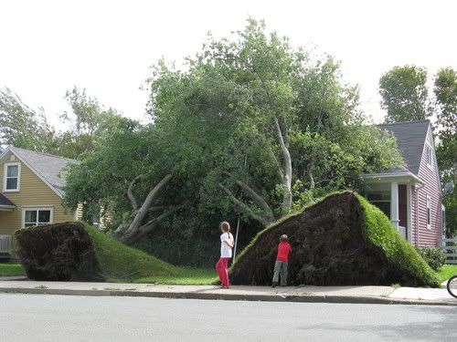
Als ik het goed bekijk zit het gras(mat) er nog niet zolang in. Gras wat al een jaartje zit zou gaan scheuren.quote:
Foto van de schade door Igor in New Foundland
[ afbeelding ]
2 beste bomen trouwens
<a href="https://www.youtube.com/channel/UCPueUwKfPaGH7v48LZlltkg" rel="nofollow" target="_blank">WSDokkum Youtube</a>
En ik geloof niet dat dat gebied woensdag (morgen dus) al bij Florida ligt. Eerder volgende week woensdag.
's Avonds een man, overdags rustig an
Waarom gaat Nicole wel vrijwel zeker naar het noorden, en ging Matthew naar het westen? Is het de locatie waar ze gevormd zijn, die net iets noordwestelijker is voor Nicole?
Trouwens, als Nicole echt zo snel noordoostelijk gaat bewegen, dan kan ze dan nog de restanten van Julia overnemen, die daar nog steeds rondsukkelen.
Trouwens, als Nicole echt zo snel noordoostelijk gaat bewegen, dan kan ze dan nog de restanten van Julia overnemen, die daar nog steeds rondsukkelen.
http://www.opnaardehorizon.blogspot.com, mijn reisblog over 6 maanden Zuidoost-Azië
Ik denk als Nicole tegen de restanten aan botst van Julia, dan blijft er denk ik niet veel meer over dan wat buien, denk niet dat die dan nog veel krachtiger gaat worden.
Al met al is het maar even afwachten wat het allemaal gaat doen, voor nu lijkt het geen ramp te worden
Al met al is het maar even afwachten wat het allemaal gaat doen, voor nu lijkt het geen ramp te worden
<a href="https://www.youtube.com/channel/UCPueUwKfPaGH7v48LZlltkg" rel="nofollow" target="_blank">WSDokkum Youtube</a>
Dat is niet best inderdaad! Er is daar ook zo fucked up veel regen gevallen de laatste weken... Niet normaal.
Voor Nicole hoeft niemand bang te worden denk ik, afgezien van de regenval op vooral Cuba.
Voor Nicole hoeft niemand bang te worden denk ik, afgezien van de regenval op vooral Cuba.
's Avonds een man, overdags rustig an
Ik denk dat Amerika ook de nodige regenval gaat krijgen. Het is een vrij grote storm, wat ongetwijfeld voor overstromingen e.d. zal gaan zorgen.

Laat die nou maar eens over NL komen serieus dat wordt een ramp
<a href="https://www.youtube.com/channel/UCPueUwKfPaGH7v48LZlltkg" rel="nofollow" target="_blank">WSDokkum Youtube</a>

Accuweatherquote:The area of showers and thunderstorms in the Caribbean that the AccuWeather.com Hurricane Center has been concerned about for days has become the Atlantic's 16th tropical depression.
The system has developed over the warm waters of the northwestern Caribbean with favorable conditions allowing an area of low pressure to become better organized.
The tropical depression has a good chance at becoming Tropical Storm Nicole over the next 48 hours.
The system is first expected to impact Cuba then to take aim at Florida and the U.S. East Coast this week.
The latest statistics on T.D. 16 can be found at the AccuWeather.com Hurricane Center.
The system could continue to strengthen while over warm water in an environment with little wind shear during the next 24 hours.
T.D. 16 will then bring eastern and central Cuba heavy rain, tropical storm-force winds and battering surf, especially along the south-central shore, late tonight into Wednesday morning.
Four to 8 inches could soak central parts of Cuba with locally higher amounts over the mountains.
Life-threatening flash flooding and mud slides can result from upwards of 6 inches of rain at the local level.
The higher terrain of Cuba could cause the system to lose strength before it moves back over the open water of the Straits of Florida on Wednesday.
Southern and central Florida and the Bahamas are in line for hefty rainfall, especially later Wednesday, that may also result in flash flooding.
High winds will slam the east coast of Florida, perhaps causing localized damage and coastal flooding.
The system will then move on to impact much of the East Coast during the latter part of this week with potentially flooding rainfall, high winds, rough surf and dangerous rip currents.
The strength and the exact track of the storm as it skirts the Eastern Seaboard are still far from set in stone.
The system will be battling strong wind shear by the time it reaches the East Coast of the U.S., and this could prevent it from strengthening or even maintaining tropical storm strength.
Even if the system is just a remnant low by the time it reaches the East Coast, heavy rainfall and flooding will be the major concern.
However, gusty winds and beach erosion could become serious problems as well.
A storm system lashing the East early this week will leave the East more vulnerable to flooding. Some parts of eastern North Carolina have been deluged by more than 10 inches of rain.
Residents and business interests of Florida, the Bahamas and the East Coast should keep checking back with AccuWeather.com for updates on T.D. 16 destined to become Tropical Storm Nicole.


Het is een beetje de vraag hoe het systeem zich ontwikkeld nadat het over Cuba is gegaan. Bij Cuba moet het over bergen heen wat de nodige afzwakking kan veroorzaken.
's Avonds een man, overdags rustig an
sixteen is een feit. Hier zal het echt niet bij blijven. Dit jaar nog een cat 10 landfall (windsnelheden tegen de 800 aan)
<a href="https://www.youtube.com/channel/UCPueUwKfPaGH7v48LZlltkg" rel="nofollow" target="_blank">WSDokkum Youtube</a>
Matthew strikes againquote:
54 doden door zware regenval in Nicaragua
In het Centraal-Amerikaanse Nicaragua heeft de zware regenval van de voorbije dagen al 54 slachtoffers geëist. Zo'n 5.000 mensen zijn dakloos, tal van wegen en bruggen zijn zwaarbeschadigd. Zo'n 8.000 woningen zijn overstroomd, meldt de regering.
Stijgend waterpeil
De tropische storm Matthew treft vooral de noordelijke provincies Estelí en Matagalpa, Chinandega in het noordwesten en het westelijke León.
In de hoofdstad Managua zorgt het waterpeil van het Managuameer voor kopzorgen. Het stijgende water vormt een bedreiging voor duizenden armen. De regering roept op tot voorzichtigheid. De regenperiode loopt ten einde in november.

[ Bericht 4% gewijzigd door Frutsel op 29-09-2010 12:24:07 ]
Bronquote:Chinese dam staat op instorten door tyfoon
XINYI - Een Chinese stuwdam die door tyfoon Fanapi zwaar beschadigd is geraakt, zal worden afgebroken. De dam vormt momenteel een gevaar voor de tienduizenden mensen die erachter wonen.
Dat meldde het Chinees staatspersbureau Xinhua woensdag.
De dam in de stad Xinyi in de zuidelijke provincie Guangdong is niet meer te repareren. Volgens experts kan het ruim 28 meter hoge bouwwerk elk moment instorten. De dam zal in fases worden neergehaald met explosieven. Op die manier kan het water uit het stuwmeer geleidelijk weglopen.
Opblazen
Woensdag zal twee keer een deel van de dam worden opgeblazen. Donderdag gebeurt hetzelfde, waarna het gevaar voor overstromingen geweken zal zijn, aldus de overheid.
Door de tyfoon kwamen eerder deze maand meer dan honderd mensen om het leven. Honderdduizenden werden geëvacueerd.
De regen die verwacht wordt. Het loopt op sommige plaatsen zelfs op tot boven de 300 mm.
Het regent nu al in dit deel van Amerika
[ Bericht 1% gewijzigd door #ANONIEM op 29-09-2010 19:39:45 ]
Het regent nu al in dit deel van Amerika

[ Bericht 1% gewijzigd door #ANONIEM op 29-09-2010 19:39:45 ]

Apart gebied. Veel regen zeg, Jamaica heeft al 8 doden te betreuren door hevige regenval. In Cuba zullen er ongetwijfeld ook doden vallen.
's Avonds een man, overdags rustig an
Vraag me af of Nicole wel de status tropische storm heeft verdiend.. Ik denk dat ze een onderzoek zullen gaan starten of dat ding uberhaupt als een TS geclassificeerd kon worden
Weer of geen weer, altijd actueel www.onweer-online.nl
Hoogst gemeten snelheid was rond de 74 km/uur. Dus dan zou het een TS zijn geweest. Maar niet lang in ieder geval.quote:Op donderdag 30 september 2010 11:11 schreef meteo-online het volgende:
Vraag me af of Nicole wel de status tropische storm heeft verdiend.. Ik denk dat ze een onderzoek zullen gaan starten of dat ding uberhaupt als een TS geclassificeerd kon worden
Er zijn al weer 2 nieuwe waves die langzaamaan ontwikkelen en westwaarts trekken, dus wellicht kom er al weer snel nieuw vuurwerk aan...
's Avonds een man, overdags rustig an
die 2 zijn inmiddels 1 geworden en opgeschroefd naar 30%quote:Op donderdag 30 september 2010 11:57 schreef Burnie88 het volgende:
Er zijn al weer 2 nieuwe waves die langzaamaan ontwikkelen en westwaarts trekken, dus wellicht kom er al weer snel nieuw vuurwerk aan...
De 'restanten' van Nicole gaan nog voor veel overlast zorgen. Vooral in de vorm van regen, maar ook gaat de wind nog een rol spelen.
Accuweatherquote:Nicole Will Hit Like a Hurricane
.
Nicole will continue to reorganize and strengthen Thursday prior to landfall in North Carolina at night.
Ignore the official classification of Nicole as a "remnant low" or even a "tropical rainstorm," as the effects will be similar to that of a hurricane from eastern North Carolina to New England.
Nicole may be changing character. However, it is getting stronger and may hit some areas from the Outer Banks to the barrier islands of New Jersey and Long Island with gusts as high as hurricane force spanning tonight and Friday.
Unfortunately, this rush to downgrade Nicole to a remnant low has lifted attention from the serious nature of the event, and may place lives and property unnecessarily in peril, since people will let their guard down as a result.
Impacts could be significant whether gusts are 40, 60 or 80 mph at various locations due to saturated ground and leafed foliage.
As Meteorologist Mark Mancuso pointed out, "The soggy ground and high winds will cause fully leafed trees to easily topple and soggy branches to fall, taking power lines with them."
As we warned about here at AccuWeather.com in recent days, conditions will be dangerous for travel in these areas tonight into Friday due to the potential number of downed trees and magnitude of flooding.
AccuWeather.com Hurricane Expert Joe Bastardi has been very concerned about the dangers from Nicole.
A period of strong onshore winds will also lead to coastal flooding, especially at times of high tide, perhaps as far inland as the upper part of the Delaware and Chesapeake bays.
Pounding surf for a time will lead to beach erosion.
Tropical banding of the rain and thunderstorms could also trigger short-lived, rain-wrapped tornadoes in coastal areas from North Carolina to southern New England.
When people wake up Friday morning, they may be wondering what hit them.
Als dat gebied van 30% goed gaat clusteren, dan kan het wel eens een hele grote jongen gaan worden.
's Avonds een man, overdags rustig an

quote:Twee doden in Jamaica door Nicole
De tropische storm Nicole heeft tijdens een doortocht op het Caribische eiland Jamaica twee doden geëist. Een dozijn andere mensen is nog steeds vermist. Het getroffen gebied werd eveneens geteisterd door overstromingen en modderstromen.
De storm ging gepaard met hevige windstoten en overvloedige regenval. Verschillende wegen werden overspoeld, dorpen werden afgesneden van enige hulp.
Zowel scholen en universiteiten als bedrijven en overheidsinstellingen blijven voorlopig gesloten. Een groot deel van het land zit momenteel zonder drinkwater. De storm heeft ondertussen koers gezet richting Cuba. (belga/svm)
Check die H dat moet een orkaan zijn  geen regen en toch orkaan
  zou een hoop elende schelen
<a href="https://www.youtube.com/channel/UCPueUwKfPaGH7v48LZlltkg" rel="nofollow" target="_blank">WSDokkum Youtube</a>
quote:East Coast Flood: The Latest Reports
by weather.com Digital Content Team
The remnants of Tropical Storm Nicole could become an historic storm for the East Coast. Millions of people are in the path of the storm, and major flash flooding concerns exist for every state from the Carolinas to Maine.
The Weather Channel is keeping you up to date on the latest flooding, high wind, and severe weather reports from this East Coast storm.
.


50% inmiddelsquote:
Gebied 1 is nu 20%. Dit kan wel wat gaan worden.
Gebied lijkt weer richting Bermuda te drijven, dus wordt weer niks waarschijnlijk.quote:
's Avonds een man, overdags rustig an
Die gelukkig als een malle naar het oosten zal trekken zonder iets te veroorzaken.
http://www.opnaardehorizon.blogspot.com, mijn reisblog over 6 maanden Zuidoost-Azië
Overstromingen treffen Chinees eiland
HAIKOU (ANP) - Het eiland Hainan in het zuidoosten van China is getroffen door zware overstromingen. Meer dan 100.000 mensen zitten vast in de stad Wanning door de aanhoudende hevige regenval. Een bijna even groot aantal mensen is geëvacueerd. Dat meldde het Chinese staatspersbureau Xinhua woensdag.
De regen teistert Hainan al zeker zes dagen. Verschillende steden, waaronder Haikou, de hoofdstad van de provincie, en badplaats Sanya, zijn ondergelopen. Honderden dorpen zijn eveneens getroffen door het wassende water.
De overheid heeft meer dan duizend reddingswerkers en militairen ingezet. Zij proberen bij de ongeveer zesduizend mensen te komen die nog vastzitten in ondergelopen dorpen. Dat is moeilijk omdat veel wegen onbegaanbaar zijn geworden.
bron
[ Bericht 6% gewijzigd door #ANONIEM op 06-10-2010 20:12:33 ]
HAIKOU (ANP) - Het eiland Hainan in het zuidoosten van China is getroffen door zware overstromingen. Meer dan 100.000 mensen zitten vast in de stad Wanning door de aanhoudende hevige regenval. Een bijna even groot aantal mensen is geëvacueerd. Dat meldde het Chinese staatspersbureau Xinhua woensdag.
De regen teistert Hainan al zeker zes dagen. Verschillende steden, waaronder Haikou, de hoofdstad van de provincie, en badplaats Sanya, zijn ondergelopen. Honderden dorpen zijn eveneens getroffen door het wassende water.
De overheid heeft meer dan duizend reddingswerkers en militairen ingezet. Zij proberen bij de ongeveer zesduizend mensen te komen die nog vastzitten in ondergelopen dorpen. Dat is moeilijk omdat veel wegen onbegaanbaar zijn geworden.
bron

[ Bericht 6% gewijzigd door #ANONIEM op 06-10-2010 20:12:33 ]

De volgende orkaan ligt al weer klaar bij de Carraïben, kijken of dat wat wordt.
's Avonds een man, overdags rustig an
Jemig, weer duikt die de Golf niet in... Ik wil een landfall zien.
's Avonds een man, overdags rustig an
Nou daar zitten de mensen in de VS op te wachten zeg... Hoewel het nu wel een naar seizoen is voor midden-amerika (mn Nicaragua, Honduras, Belize en Mexico).
http://www.opnaardehorizon.blogspot.com, mijn reisblog over 6 maanden Zuidoost-Azië
Ik heb minder medelijden met Amerikanen dan met mensen uit Midden-Amerika kan ik je vertellen. Nee, ik vind de gevolgen van Katrina echt niet leuk ofzo, maar ik kan wel genieten van de oplopende spanning, de impact van moeder natuur, enz. Maar ik denk dat de meeste volgers van dit topic dat wel hebben.
's Avonds een man, overdags rustig an
Jah ik snap je punt. Mensen in dit topic vinden het boeiend als er iets gebeurt. Maar eigenlijk is zo'n Igor van dit seizoen een stuk boeiender dan een orkaantje dat landfall maakt ergens in midden of noord amerika. Dat was toch 1 van de mooiste plaatjes van een orkaan. En dan zie je dat het interessante van dit onderwerp niet persé gelijk hoeft te zijn aan rampen voor mensen (hoewel in dit geval Bermuda een beetje in de weg lag ).
http://www.opnaardehorizon.blogspot.com, mijn reisblog over 6 maanden Zuidoost-Azië
Nee, daar heb je gelijk in. We hebben dit seizoen al heel mooie orkanen gezien op de Atlantische Oceaan, maar je ziet er zo weinig van aangezien ze geen landfall maken. Oké, radarbeelden zijn mooi, maar ik vind palmbomen die bijna tegen de grond aan hangen door de wind veel mooier om te zien (icm radarbeelden). Maar ik heb het ook niet over orkanen van cat. 1 die landfall maken, orkanen als Wilma en Katrina zijn pas echt boeiend wat betreft landfall.
's Avonds een man, overdags rustig an

quote:Paula verantwoordelijk voor een nieuw record
Tropische orkaan Paula heeft zich in 12 uur tijd ontwikkeld van een tropische depressie tot een orkaan. Daarmee is Paula de eerste orkaan die in zo'n korte tijd tot ontwikkeling is gekomen.
Dinsdagavond was de druk gedaald tot 982hPa en daarmee is het een orkaan van de tweede categorie. De verwachting is dat het systeem min of meer stationair wordt en voor grote hoeveelheden regen kan zorgen in o.a. het westelijke deel van Cuba.
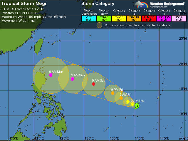

Dit kan weleens een dodelijke typhoon worden.quote:Op woensdag 13 oktober 2010 16:41 schreef Frutsel het volgende:
Tyfoon Megi
[ afbeelding ]
Dat wordt een behoorlijke joekel
Categorie 4 inmiddels
bronquote:Megi, the latest named storm for the western North Pacific Ocean basin, has formed over the southern Philippines Sea.
As of Wednesday morning, the center of Tropical Storm Megi was 310 miles west-southwest of Guam and more than 1,300 miles east of Manila, Philippines. Megi held highest sustained winds of 50 mph and was drifting towards the west at about 5 mph.
Megi will strengthen as it tracks towards the west and northwest over open seas for the next few days. Strengthening to a typhoon is forecast. Moreover, rapid strengthening to a major typhoon, even a "super" typhoon, is possible, as both oceanic and atmospheric conditions are favorable.
Eventually, Megi will either strike the main northern Philippines island of Luzon, or it will veer northward, away from Philippines, over the western Philippines Sea.
Direct typhoon landfall upon heavily settled northern Luzon would pose a serious threat to life and property.

ik denk dat het voorlopig daar rumourig blijft 
Yvonne schreef op maandag 31 oktober 2011 @
13:59:43 in DEF SC #282 aan AchJa & Co
Vanaf hier en nu stopt het in DEF én op FOK!
Ik wil hier een normale SC zonder gebitch!
13:59:43 in DEF SC #282 aan AchJa & Co
Vanaf hier en nu stopt het in DEF én op FOK!
Ik wil hier een normale SC zonder gebitch!
Paula

quote:Data from an Air Force Hurricane Hunter aircraft indicates that Hurricane Paula continues to weaken, and the storm may no longer be a hurricane. The latest 8:06am EDT center report found the pressure had risen to 1002 mb, and the aircraft saw top winds at their flight level of 10,000 feet of just 60 mph between 6am and 9am EDT. The Hurricane Hunters did not report the existence of an eyewall, and Cuban radar (Figure 1) indicates that the southern portion of the eyewall has collapsed, leaving Paula with just 1/3 of an eyewall. Paula is moving at 5 mph along the northern coast of Cuba, and is bringing heavy rains to the western portion of the island. Cabo San Antonio on the western tip of Cuba has picked up 4.85" of rain so far from Paula, and a wind gust of 60 mph was reported on the western tip of the island. Heavy rains have also hit the Florida Keys this morning, with Key West picking up 0.62" inches of rain in just 30 minutes from a heavy rain squall that ended at 7:30am EDT. Weather radar out of Key West (Figure 2) noted several regions offshore where Paula has dumped 5+ inches of rain. High wind shear due to strong upper-level winds of 30 knots out of the south are tearing Paula apart, and satellite imagery shows the storm has a lopsided appearance due to the shear, and the low-level center is almost exposed to view. Low level spiral banding is no longer as impressive, and the intensity of Paula's thunderstorms has waned significantly over the past few hours.
Forecast for Paula
The models have come into better agreement on the future track of Paula, with the storm expected to move along the north coast of Cuba or just inland during the next three days. On this track, Paula will move over Cuba's capital, Havana, tonight and Friday morning, and bring heavy rains of 3 - 6 inches to the most populous region of the country. An extended period of time over mountainous Cuba will likely destroy a small storm like Paula within 48 hours, particularly since the storm will be under 30+ knots of wind shear. A path just off the coast will let Paula live a little longer, but not much longer. The models are pretty unanimous in showing that wind shear will pull Paula apart over the next two days regardless of whether or not the center stays over water. Tropical storm force winds extend out just 50 miles from Paula's center, so it is unlikely that the Florida Keys will experience sustained winds of 39+ mph. The 5am EDT wind probability product from NHC gives Key West a 40% chance of receiving tropical storm force winds; these odds are 83% for Havana. Havana may receive some minor wind damage from Paula, but it currently appears that heavy rain will be the major threat from Paula. The hurricane could easily dump more than ten inches over mountainous regions of Cuba, creating flooding hazards.
Nu weer een nieuw gebied van 10% bij de Carraïben wat potentieel heeft om zich te ontwikkelen.
's Avonds een man, overdags rustig an
40% inmiddelsquote:
Nu weer een nieuw gebied van 10% bij de Carraïben wat potentieel heeft om zich te ontwikkelen.
Leuke anekdote van zon hurricanewatcher:
quote:I might have jinxed the system
Even though we humans have no control over the large scale weather systems such as hurricanes, we can often joke about jinxing things one way or another. This may be one of those cases. I said yesterday that I did not think 99L would develop- this was due to land interaction and the fact that the global models were pushing it west in to Central America and/or out in to the east Pacific. Well, this is clearly not happening and it may be that sooner rather than later we have a depression on our hands.
We may know more later today as the NHC has tasked a recon plane to go out and investigate the system if it looks to be on the uptick this afternoon. Just looking at satellite shots, you can clearly see it is growing in size and organization and it is not moving in to Central America
The GFDL model was the most robust with development- showing it becoming quite a strong hurricane in the northwest Caribbean over the next five days
Even the HWRF model is suggesting fairly significant development- though at a slow pace.
The bottom line is that we will need to monitor this system closer now. People with interests in the northwest Caribbean from the Caymans to western Cuba to the Yucatan could be dealing with off and on squalls as the system organizes and drifts slowly around the region. I'll post another update later this afternoon when/if the recon plane heads out to investigate.
Dat zal weer voor problemen zorgen in Nicaragua en Honduras
[ Bericht 3% gewijzigd door #ANONIEM op 19-10-2010 15:58:30 ]
[ Bericht 3% gewijzigd door #ANONIEM op 19-10-2010 15:58:30 ]
En Richard gaat snel weer oplossen omdat hij de Golf niet in zal trekken voor de zoveelste keer.
's Avonds een man, overdags rustig an
Myanmar krijgt ook weer een pleur water.
Hopelijk gaat deze niet in zeer korte tijd ook enorm groeien zoals Nargis


Ik denk het niet, die depressie wordt nog even TS (cat. 1 moet ik nog zien) en lost daarna op boven Yucatan.
's Avonds een man, overdags rustig an

quote:Thursday October 21, 2010 7:00 AM EDT Update
TD#19 is drifting around in the western Caribbean, but forecast to move over the Yucatan closer to Monday as a hurricane, those in the Yucatan will want to watch this system very closely, and possibly Florida later.
If the forecast verifies, after weakening over the Yucatan it may have a chance to enter the southern Gulf, and from there possibly affect the north central or northwestern Gulf, a large high pressure should keep it west of Florida, again if it does make it into the Gulf shear will likely affect it adversely and keep the system weak.
If the system moves further north more quickly than forecast it could maintain hurricane strength and approach Florida from the west, so it will be worth watching in that scenario. If this situation were to occur, it would probably be near the 26th..
Based on the official forecast, the Yucatan has the most to worry from the system, and beyond some rainfall for a portion of the gulf coast west of Florida seems most likely, but there will be plenty of time to watch the system over the coming days.
Ik denk dat Richard nog wel even cat. 2 gaat worden voordat hij landfall gaat maken.
's Avonds een man, overdags rustig an

TS: Hey daar hebben we Cat 1! Alles goed
Cat 1: Jazeker maar ik ga aan de koffie dus laat het verder over aan Cat 2
Cat 1: Jazeker maar ik ga aan de koffie dus laat het verder over aan Cat 2
<a href="https://www.youtube.com/channel/UCPueUwKfPaGH7v48LZlltkg" rel="nofollow" target="_blank">WSDokkum Youtube</a>
Ja dat gaat wel bizar snel van cat. 1 naar 2. Zijn de warmteverschillen van het zeewater daar zo groot ofzo? Of het heeft te maken met wind shear, kan ook.
's Avonds een man, overdags rustig an
quote:Het wordt gewoon weer een catastrofale CATEGORIE VIER storm die Birma gaat treffen
Ja dat gaat wel bizar snel van cat. 1 naar 2. Zijn de warmteverschillen van het zeewater daar zo groot ofzo? Of het heeft te maken met wind shear, kan ook.
Of is dat rode nog een drie?
"Nargis-flasback heeft"
Hm... Richard gaat wel de golf in...iets meer draaien nog en hij heeft iets meer tijd en warm water om alsnog uit te groeien tot een orkaan
Tyfoon Chaba gaat wat eilandjes pesten

Vertrouw die zooi maar niet, moet je eens kijken naar het plaatje met die procenten,.....hij lijk zelf verbaast te kijken
Als dat maar goed gaat...
Als dat maar goed gaat...
<a href="https://www.youtube.com/channel/UCPueUwKfPaGH7v48LZlltkg" rel="nofollow" target="_blank">WSDokkum Youtube</a>
quote:Dit zou dan Tomas moeten worden... en lijkt de meest gevaarlijke van de drie... Ben zeer benieuwd wat dit systeem nog kan doen zo laat in het seizoen.91L
This is the system that I am most concerned about in the longer term. It is located to the east-southeast of the southern Windward Islands and has a large envelope of energy associated with it. Conditions look to be getting more favorable by the hour. The SHIPS intensity model is quite bullish on this developing down the road and it could reach the Windwards as a tropical storm. Once it enters the Caribbean Sea, it looks as though it should have gained enough latitude to stay clear of the South American land mass. This means we could be looking at a strengthening tropical cyclone moving through the eastern and central Caribbean early next week. What we do not want to see is this getting anywhere near Haiti and moving slowly at that. This time of year, tropical cyclones can move quite slowly and be sprawling weather systems- capable of dumping a lot of rain. Haiti has been very fortunate this season to avoid any tropical issues but we will need to monitor this situation very closely. There is also a chance this feature eventually threatens Jamaica and southeast Cuba but we're talking well beyond the normal time frame of reliable forecasts. I expect that the NHC will upgrade 91L to "high" chance of development later this evening.
Tomas lijkt inderdaad een gevaarlijke te worden. Die kan weleens een probleem gaan worden voor Haiti etc....


quote:A tropical system that could garner the name "Tomas" will take center stage in the Caribbean, threatening populated areas and perhaps making a bad situation in Haiti much worse.
While people on the Leewards, the Virgin Islands and Puerto Rico may be able to breathe a sigh of relief, concerns are shifting farther to the south and west in the Caribbean.
This weekend, the system will unload heavy rainfall over the Windwards, Trinidad and Tobago, Venezuela and the small islands bordering the Cariaco and Bonaire basins.
Locales in this region may be hit with rainfall rates of up to several inches per hour, unleashing flash flooding, washouts and mudslides. Rough seas will endanger small craft and fishing interests.
Close proximity to South America will interfere with the system's strength this weekend. However, AccuWeather.com meteorologists have great concerns beyond the weekend.
The overall large size of the feature may allow it to persevere as it navigates the northern edge of the large land mass.
During the first part of next week, there are indications the system may drift into the open waters of the central Caribbean. This would prop the door wide open for rapid intensification.
Possible paths next week range from a direct strike on Haiti to a farther west path toward Jamaica or even Central America. It appears the westerlies would prevent a strike on the U.S.
It would be a horrible scenario if the system were to turn to the north and slam Haiti as a hurricane. Unfortunately, that is at least a possibility at this point.
After being devastated by a powerful earthquake last winter, cholera is now claiming lives in Haiti. Even a glancing blow from a hurricane or a brush with a tropical storm could lead to catastrophe from flash flooding and mudslides.
It would also be ironic, as Haiti has dodged many bullets from the tropics this season, only to be hit by possibly the last hurricane of the 2010 Atlantic season.
Hurricane season does not officially end until November 30.

Die gaat Jamaica aan doen, let maar op!
<a href="https://www.youtube.com/channel/UCPueUwKfPaGH7v48LZlltkg" rel="nofollow" target="_blank">WSDokkum Youtube</a>
Het is nu al een groot systeem.
Windsnelheid van 104 km/uur met windstoten tot 120 km/uur (tropische storm)
Minimale luchtdruk is 997mb
[ Bericht 3% gewijzigd door #ANONIEM op 30-10-2010 08:49:23 ]
Windsnelheid van 104 km/uur met windstoten tot 120 km/uur (tropische storm)
Minimale luchtdruk is 997mb

[ Bericht 3% gewijzigd door #ANONIEM op 30-10-2010 08:49:23 ]
Curaçao, Bonaire en Aruba klaar voor tropische storm
WILLEMSTAD - Curaçao bereidt zich voor op de tropische storm Tomas. Dat verklaarde minister-president Gerrit Schotte vrijdagavond op een ingelaste persconferentie in Willemstad.
Tomas zal naar verwachting in de nacht van zondag op maandag (lokale tijd) op ongeveer 250 km ten noorden van Bonaire, Curaçao en Aruba passeren. Dit zal gepaard gaan met hevige buien en veel wind.
Schotte verklaarde dat de draaiboeken van het rampenteam in werking zijn gesteld. Dat betekent onder meer dat de shelters in staat van paraatheid worden gebracht en vissers wordt aangeraden de zee te mijden.
Ook op de andere eilanden wordt de ontwikkeling van Tomas nauwgezet in de gaten gehouden. Voor een aantal Caraïbische eilanden is een orkaanwaarschuwing uitgevaardigd. Het Amerikaanse Orkaancentrum verwacht dat Tomas zal uitgroeien tot een sterke orkaan van vierde categorie.
© ANP
nu.nl

Er lijkt ook weer wat te ontstaan in de Indische Oceaan.

quote:A tropical cyclone could bring damaging wind and flooding rain to eastern India at the end of the week.
As of Wednesday, a tropical weather system, formerly a tropical depression near the Malay Peninsula, was gathering over the Andaman Sea. This weather system will organize into a tropical depression and later, a tropical cyclone, over the open Bay of Bengal by Friday.
The latest information indicates that landfall of a cyclone of tropical storm or even hurricane strength is projected to take place on or about Sunday. It is likely landfall would be in the southeastern state of Andhra Pradesh.
The greatest threat to life and property will stem from torrential rain and flooding, especially near the coast.
Also a threat will be damaging winds and even a flooding storm tide.
This tropical weather system already has a history of adverse weather. It triggered flooding rain over southernmost Thailand on Sunday and Monday.

Staat nog niks op de kaart toch aloa? Ik ben benieuwd, Thomas wordt ook weer een lachertje, dus hoop nog steeds op een cat. 4 of 5 in de Golf.
's Avonds een man, overdags rustig an
Ik hoop een cat 2 hier in NL.
We hebben zoveel te willen maar of het uitkomt
We hebben zoveel te willen maar of het uitkomt
<a href="https://www.youtube.com/channel/UCPueUwKfPaGH7v48LZlltkg" rel="nofollow" target="_blank">WSDokkum Youtube</a>
Gaat hem niet worden dit jaar ben ik bang. Statistisch gezien zou Tomas heel goed de laatste storm van het jaar kunnen zijn. Ik voorspel nog 1 laf tropisch stormpje dat nergens schade aanricht en dan de winter afwachten. Maar je weet het nooit, tis natuurlijk een behoorlijk actief seizoen geweest.quote:Staat nog niks op de kaart toch aloa? Ik ben benieuwd, Thomas wordt ook weer een lachertje, dus hoop nog steeds op een cat. 4 of 5 in de Golf.
http://www.opnaardehorizon.blogspot.com, mijn reisblog over 6 maanden Zuidoost-Azië