WKN Weer, Klimaat en Natuurrampen
Lees alles over het onstuimige weer op onze planeet, volg orkanen en tornado's, zie hoe vulkanen uitbarsten en hoe Moeder Aarde beeft bij een aardbeving. Alles over de verwoestende kracht van onze planeet en tal van andere natuurverschijnselen.


Not yetquote:Op zondag 4 juli 2010 22:26 schreef aloa het volgende:
Het is nu een Tropische Depressie (35 miles/uur).
Lijkt erop dat de 2e storm met een naam in aantocht is.
Dat gaat dan Bonnie worden.
van mij mag het ff rustig blijvenquote:Op maandag 5 juli 2010 08:15 schreef aloa het volgende:
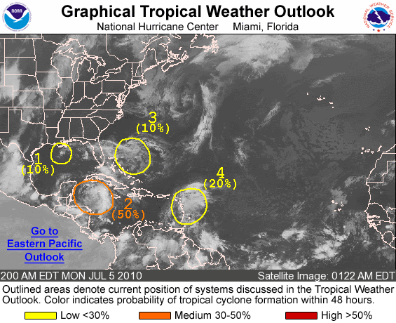
50% nu. En het lijkt druk te gaan worden.
[ afbeelding ]
moet woensdag via mexico naar guatemala....
Er zijn nu nog 3 gebieden over. 2x 10 % en een gebied met 40% kans op tropisch storm.
Die van 40% zit in de buurt van Quatemala en mexico
http://www.nhc.noaa.gov/gtwo_atl.shtml
[ Bericht 0% gewijzigd door #ANONIEM op 05-07-2010 15:33:17 ]
Die van 40% zit in de buurt van Quatemala en mexico
http://www.nhc.noaa.gov/gtwo_atl.shtml
[ Bericht 0% gewijzigd door #ANONIEM op 05-07-2010 15:33:17 ]
quote:
The first area, 95L in the Gulf, is a very small low pressure area that, for a bit yesterday, spun up quite a bit. Even though in all likelihood nothing will ever develop out of the system, it still needs to be watched because it is so small and so close to land. It has the potential to spin up very quickly because of the small size, but more likely to spin out/down ever faster. Conditions around it favor no development.
The second area being tracked is the tropical wave (96L) in the Western Caribbean. It has the best chance,currently, of all the areas to develop, but looks to remain on the weaker side. Looking at satellite imagery this morning it is not looking that great. It is on the edge of a shear zone, and it has ok outflow, but it hasn't really persisted enough. It still has a fairly high chance of development, but just not today. If this one develops, it is most likely going to stay weak. It is bringing rainfall to the Caymans and the Yucatan.
With 96L being a weaker system it implies a more westerly move, but the overall patter is less so than it was for Alex. Recon was scheduled to go out to the system today, but it was canceled because of how poorly organized it looks this morning. They may try again tomorrow.
The final wave is in the east Caribbean which may be worth watching later in the week when it arrives in the western side, but until then it'll just be watched.
The area northeast of the Bahamas is now off the list.


Toch nog redelijke kans op opwaardering tot tropische storm. Bonnie on it's way?quote:Bonnie heading for South Texas?
A week after Hurricane Alex slammed onshore, a new tropical system that is being monitored for development will target South Texas and northeastern Mexico on Thursday.
Despite tracking well away from the oil spill area, the system still threatens to disrupt cleanup and containment efforts in the northern Gulf and could lead to flooding problems along and inland of the Texas Coast.
Latest on the Tropical System
The system being monitored for development has just exited the northern Yucatan Peninsula. The system is rather disorganized with no thunderstorms wrapping around a well-defined center, after being beaten up by the large land mass.
The system could become better organized as it heads northwestward. Enough strengthening could take place that the second tropical depression or tropical storm of the season develops by midday Thursday.
The next tropical storm in the Atlantic Basin would acquire the name "Bonnie."
The water in the western Gulf of Mexico is warm enough to support strengthening. Strong winds high in the atmosphere, also known as wind shear, will be absent.
Current forecast models indicate that if a tropical storm does develop, the system will probably press inland too quickly to intensify into a hurricane. South Texas or far northeastern Mexico is where the system should move onshore on Thursday, although perhaps farther north than Alex's landfall.
Even if development does not take place, the system threatens to unleash drenching thunderstorms around and north of its center. Additional rainfall on already soaked South Texas and northeastern Mexico could lead to new flooding problems.
For now it appears the heaviest rain would fall along the middle Texas coast, due to the lopsided nature of the system at this time.

nou, ben op.. 6000meter er recht overheen gegaan..
een beetje turbulentie.. en dat was het dan.
vele groeten uit Guatemala.
een beetje turbulentie.. en dat was het dan.
vele groeten uit Guatemala.
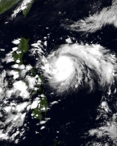
Tropische storm Conson bij de Filipijnen
[ Bericht 6% gewijzigd door #ANONIEM op 12-07-2010 11:22:18 ]
[ Bericht 6% gewijzigd door #ANONIEM op 12-07-2010 11:22:18 ]

Deze gaat recht op de Filipijnen af. Als een categorie 1. Nu heeft deze storm een windveld van 112 km/uur en windstoten tot 136 km/uur.
9 doden op de Filipijnen.
quote:Tyfoon Conson geselt noorden Filipijnen
(Novum/AP) - De eerste tyfoon die dit jaar de Filipijnse kust bereikte, heeft woensdag stevig huisgehouden in de hoofdstad Manilla. Straten overstroomden en elektriciteitskabels braken af, met stroomstoringen als gevolg. Zeker negen mensen verloren het leven, terwijl tien vissers worden vermist.
Tyfoon Conson raasde met windsnelheden van 120 kilometer per uur over de provincie Quezon, gelegen op het eiland Luzon. Hier zwakte Conson af tot een tropische storm die verder noordwaarts Manilla een uur of twee geselde met harde windstoten en slagregens. Daarna boog Conson af richting de Zuid-Chinese Zee. Verwacht wordt dat hij later deze week ten westen van Macau het Chinese vasteland bereikt.
Onder de doden zijn een vrouw en kind die in de provincie Cavite, ten zuiden van Manilla, door een vallende boom werden getroffen. Een ander kind verdronk toen het in Novelata in een snelstromende rivier viel. Nog twee kinderen overleden toen een boom op hun huis viel en een 47-jarige vrouw werd geëlektrocuteerd door een afknappende elektriciteitskabel. In de provincie Camarines Norte kwamen nog eens drie mensen om.
Negentien vissers werden vermist nadat hun bootjes in het noodweer omsloegen. De kustwacht zette een zoekactie in touw en wist negen vissers te redden.
bron
Reuters:
quote:Conson kills 26 in the Philippines
Typhoon Conson has killed 26 people so far in the Philippines. Phot:Reuters
The first typhoon of the year to hit the Philippines has killed at least 26 people and left millions without electricity on the main island, Luzon. President Benigno Aquino criticised weather forecasters who'd failed to predict that the storm would hit the capital, Manila. In the meantime, Macau has raised its No.1 typhoon signal as Conson moves over the South China Sea towards Western Guangdong. And, the Hong kong Observatory says it will consider tomorrow whether to raise the strong storm signal number one.


quote:
 Op
Op Ik las het vanmorgen
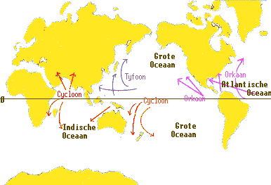
Is gewoon hetzelfde. Hieronder een kaartje om het duidelijk te maken.quote:Op woensdag 14 juli 2010 19:21 schreef j95 het volgende:
[..]
Ik las het vanmorgenDan gelijk mijn eerste vraag, is er een verschil tussen een tyfoon en een orkaan?
quote:Dodental tyfoon Filipijnen loopt op
MANILLA (ANP) - Het dodental van de tyfoon Conson op de Filipijnen is opgelopen tot zeker 36. Dat hebben de autoriteiten in Manilla donderdag meegedeeld. Zeker 46 mensen worden nog vermist. Bijna negenduizend mensen zijn dakloos geworden en hebben hun toevlucht gezocht in een opvangkamp.
Conson is de eerste tyfoon van het seizoen. Hij raasde dinsdagavond laat over het eiland Luzon, waarop de hoofdstad Manilla ligt. De hoofdstad zelf, waar ongeveer elf miljoen mensen wonen, had vooral woensdag van de wind te lijden. De Filipijnen worden elk jaar getroffen door ongeveer twintig tyfoons. De archipel ligt in de zogeheten tyfoongordel in de Stille Oceaan.
bron
Het begint weer wat drukker te worden.. belooft nog wat aangezien Aug. en Sep. de drukste maanden zijn wereldwijd voor stormen 
Conson is inmiddels weer terug naar typhoon cat.1 status...
06E is nog niet echt spannend....
En 2 gebieden in de atlantic

Conson is inmiddels weer terug naar typhoon cat.1 status...

06E is nog niet echt spannend....
En 2 gebieden in de atlantic

quote:Tientallen vissers verrast door zware tyfoon op Filipijnen
Op de Filipijnen zijn tientallen vissers verrast door een zware tyfoon. Al zeker 38 mensen kwamen om het leven door de storm.
Hulptroepen hopen nog een paar van de 29 vermiste vissers uit het water te halen, maar de tijd dringt en de slachtoffers lopen het risico op onderkoeling. De kustwacht zoekt vooral in de baai van Manila. Sommige vissers zouden op één van de eilandjes gestrand kunnen zijn.
De Filipijnen liggen in het centrum een tyfoon-rijk gebied. Jaarlijks krijgen ze te maken met zo'n 20 tropische stormen en daarbij komen honderden mensen om het leven. Deze tyfoon kreeg de naam Conson en is de eerste van het seizoen. Veel inwoners van Manila waren verrast door de enorme kracht van Conson.
De storm vernielde enkele voorsteden van Manila en plaatste de hele hoofdstad zonder stroom. Het leven kwam voor de twaalf miljoen inwoners letterlijk tot stilstand. De stroompanne zou nog enkele dagen kunnen duren, tot woede van bedrijfsleiders die een economische ramp vrezen. Volgens een Chinees weerstation is Conson nu op weg naar China. (gb)
bron