WKN Weer, Klimaat en Natuurrampen
Lees alles over het onstuimige weer op onze planeet, volg orkanen en tornado's, zie hoe vulkanen uitbarsten en hoe Moeder Aarde beeft bij een aardbeving. Alles over de verwoestende kracht van onze planeet en tal van andere natuurverschijnselen.


rtlquote:Storm Earl op weg naar de Antillen
Op de Nederlandse Antillen is een stormwaarschuwing uitgevaardigd voor Sint Maarten, Sint Eustatius en Saba. De tropische storm Earl passeert daar morgennacht.
Weerkundigen verwachten dat de storm aantrekt tot orkaankracht. Een vliegtuig van het NHC, het Amerikaanse orkaancentrum, houdt Earl daarom de komende uren goed in de gaten.
Of de Antillen ook echt te maken krijgen met een orkaan is nog niet te zeggen. Voorlopig lijkt het zwaartepunt van de storm net ten noorden van de bovenwindse eilanden langs te trekken.
[ Bericht 3% gewijzigd door #ANONIEM op 29-08-2010 08:50:09 ]

nu.nlquote:Orkaan-waarschuwing voor Antillen
MIAMI - De stormwaarschuwing voor Sint Maarten, Sint Eustatius en Saba is veranderd in een orkaanwaarschuwing. Dit in verband met de komst van tropische storm Earl die zondagochtend volgens meteorologen zal aanzwellen tot een orkaan.
Dat maakte het Amerikaanse orkaancentrum (NHC) in de nacht van zaterdag op zondag bekend.
Earl wordt binnen 48 uur verwacht op de bovenwindse Nederlandse Antillen. Het orkaancentrum raadt mensen aan zo snel mogelijk maatregelen te nemen om hun bezittingen en zichzelf te beschermen.
Eerder vandaag werd bekend dat demissionair premier Jan Peter Balkenende de komende dagen de Nederlandse Antillen zal bezoeken.
Van zondag tot dinsdag reist de hij langs de verschillende eilanden ter voorbereiding op een slotconferentie over de nieuwe staatkundige verhoudingen binnen het Koninkrijk der Nederlanden. Zondag zal Balkenende Sint Maarten aandoen. Maandag vertrekt hij naar Curaçao.
inderdaad ja... ik ben ook benieuwd hoe die koers nog gewijzigd gaat worden. Hij trekt steeds dichter langs de kust.quote:Op zondag 29 augustus 2010 13:10 schreef Frutsel het volgende:
[ afbeelding ]
Eh... een Cat 3 gaat toch vrij dicht langs de oostkust?
Kon nog wel eens problemen opleveren


Morgen gaat hij op 39 miles langs St. Maarten. Kreeg een mooie website door van een collega hier, www.stormpulse.com
quote:Op zondag 29 augustus 2010 19:48 schreef Stienn het volgende:
Morgen gaat hij op 39 miles langs St. Maarten. Kreeg een mooie website door van een collega hier, www.stormpulse.com
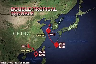
quote:Twin Tropical Systems Threaten Flood Wary China
.A pair of tropical systems threaten to produce even more flooding across flood wary eastern China.
Tropical Storm 07W, dubbed Lionrock, continues to slowly spin toward the southeast China coast, near Hong Kong. Despite being a weak tropical storm, the slow-moving nature of this system has the potential to unleash very heavy rainfall in a short period of time.
The tropical storm will push inland along the southern Chinese coast, likely just east of Hong Kong, during the day on Monday. Heavy rain would be the main impact in this scenario to Hong Kong, though winds may gust between 30-40 mph.
It is also possible that the system will stall just offshore. The system would then have an opportunity to continue strengthening, potentially into a hurricane.
If this solution pans out, the exact weather pattern that unfolds this week would dictate the system's final landfall.
Rainfall totals throughout southeast China by midweek will average 10-20 inches from Lionrock. This will lead to widespread major flooding and could also trigger life-threatening mudslides.
A New Tropical Threat
A new tropical system has quickly developed and poises a new threat to portions of northeast China this week.
Tropical Storm 08W formed on Saturday, EDT, over the northern Philippine Sea and could threaten portions of northeast China by midweek and the Korean Peninsula by the end of the week.
This storm is moving northwestward and will continue to do so over the next few days, crossing Japan's Ryukyu Islands on Monday night or Tuesday, EDT. As this system moves northwestward, further strengthening is expected, and it's likely that this storm becomes a typhoon before crossing the Ryukyu Islands.
Once in the Yellow Sea, further strengthening is possible as it approaches the coast of China near the major city of Shanghai. Heavy rain and gusty winds, perhaps as high as hurricane strength, can impact the city starting on Tuesday night, EDT.
This storm will likely curve northward and head toward the Korean Peninsula by the end of the week. The storm's torrential rain will take aim on the northeastern Chinese province of Liaoning and neighboring parts of North Korea on Thursday and Friday.
The rain poses a serious danger to lives by triggering widespread flooding and mudslides. Recent torrential rain has made eastern Liaoning and nearby North Korea extremely vulnerable to new flooding problems.
Heavy rain soaked the border of China and North Korea more than a week ago. The Chinese town of Kuandian Manzu was inundated with nearly 15 inches of rain from August 19th to the 22nd.
The heavy rain brought the Yalu River (or Amnok River as it's known in North Korea) out of its banks. The rising water punctured a dike that usually protects Dandong, China, from the river.
Stienn en mijn eerste orkaantje word Earl  (zijn roommates hier)
update: 21:14 lokale tijd hier op sint maarten.
Regen regen regen...wind word ietsje steviger...
veel water gekocht en canned food
EDIT: Collega zegt net dat het pas om 8 uur morgenochtend los gaat hier...
Vroeg opstaan dus om alles mee te maken live updates volgen...(als inet het blijft doen)
update: 21:14 lokale tijd hier op sint maarten.
Regen regen regen...wind word ietsje steviger...
veel water gekocht en canned food
EDIT: Collega zegt net dat het pas om 8 uur morgenochtend los gaat hier...
Vroeg opstaan dus om alles mee te maken

Zag net in de nieuwe run dat het Europese model voor EARL dezelfde koers volgt als de GFS. Dat zijn de meest westelijke lijnen aldus de voorspellingen, dus de koers het dichtst bij de US Eastcoast.quote:EARL
Earl is really starting to crank up. The pressure continues to fall as its organization improves. This is not unexpected and I hope that people in the path are ready for a rough night. As I mentioned in the post from earlier today, an intensifying hurricane packs more punch (this is our team's experience from personal observations) than one that is level or weakening. As far as pin-pointing exactly where Earl will track over the next 24 hours, it's tough to call as wobbles here and there could bring the core over a certain island or, conversely, keep it off. Why do they wobble? A lot of it has to do with a hurricane spinning like a top on a table (see the movie "Inception"?) and the axis seems to move around the common area of rotation. A hurricane's core bounces around inside the larger area of circulation and so we get the wobbles instead of a perfectly straight path. In any case, the area of the northern Caribbean Sea will experience quite a squally night with some areas actually receiving hurricane conditions.
The latest data indicates that Earl should miss Puerto Rico to the north. This is obviously good news for that island. But, we cannot be absolutely sure until the center has passed by. Heavy rains and windy conditions along with rough surf are a sure bet. The weather will improve by Tuesday.
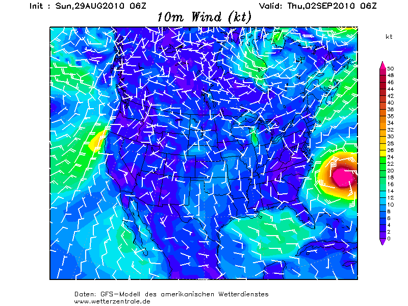
As for a possible impact on the U.S.- the latest run of the global models from late this afternoon continue to suggest that Earl will remain just far enough off the East Coast to keep the worst weather off shore. We are talking still only a hundred miles or so and that meaning the difference in a breezy day with rain and possible hurricane force winds, tidal flooding and torrential rains. I think the key remains how strong the ridge of high pressure is between Earl and departing Danielle. If it holds firm or inflates some, like a large balloon, then it could easily push Earl more west and closer to the NC coast and then Cape Cod or Maine. Folks in Nova Scotia seem especially in the line of fire and now we're looking to see if Earl goes in to the Bay of Fundy (very bad) or skirts the coast to the southeast (much better). So still no conclusion as to what Earl will do in the end. I do expect that tonight's major global model run will yield more solid clues. I know it's tough to want to know what will happen in definitive terms, but it's not usually that easy.
FIONA
For those wondering about 97L and future Fiona, it is coming. The system is very large and is taking its own sweet time to develop. While you may think this is good news, it really isn't for the longer these enormous Cape Verde tropical waves take to develop, the farther west they usually track. This may be why the ECMWF model now shows it getting in to the Gulf of Mexico going past south Florida and over Cuba. I will address this more and more throughout the week but we need to keep a calm about ourselves and deal with Earl first. Fiona-to-be is not going to impact land for several days if at all. As is always the case, we will get more pieces to this complex puzzle with each passing model cycle. I will have another update here tomorrow morning by 10am ET (and yes, I plan to be on time with this one, sorry tonight's was later than I had planned. A lot is going on and I am trying to keep up).
Fiona kon wel eens een cat 4/cat.5 worden...
Nou maar ff een update. Het is hier nu 07:48. De kern van earl gaat het komende uur op iets van 50 km langs st. Maarten. Tot nu toe valt het heel erg mee heb ik het idee, heb de hele nacht in coma gelegen. De wind word wel steeds wat sterker.quote:
50 km, dan zou je orkaankracht moeten krijgen.quote:Op maandag 30 augustus 2010 13:52 schreef Stienn het volgende:
[..]
Nou maar ff een update. Het is hier nu 07:48. De kern van earl gaat het komende uur op iets van 50 km langs st. Maarten. Tot nu toe valt het heel erg mee heb ik het idee, heb de hele nacht in coma gelegen. De wind word wel steeds wat sterker.
Gaat Danielle nou tegen de jetstream inboksen en (extratropical) landfall maken op oost-Groenland? Dat kan toch helemaal niet?
Dat gaat niet lukken inderdaad. Waarschijnlijk wordt deze meegenomen door de straalstroom, die over groenland kronkelt.quote:Op maandag 30 augustus 2010 14:34 schreef thijsdetweede het volgende:
Gaat Danielle nou tegen de jetstream inboksen en (extratropical) landfall maken op oost-Groenland? Dat kan toch helemaal niet?
http://media.weeronline.n(...)t3/10090206_3006.gif
Wel bizar veel regen misschien?quote:Op maandag 30 augustus 2010 13:52 schreef Stienn het volgende:
[..]
Nou maar ff een update. Het is hier nu 07:48. De kern van earl gaat het komende uur op iets van 50 km langs st. Maarten. Tot nu toe valt het heel erg mee heb ik het idee, heb de hele nacht in coma gelegen. De wind word wel steeds wat sterker.
's Avonds een man, overdags rustig an
Ook Fiona is inmiddels gearriveerd en ook daarachter zit alweer een nieuw gebied dat een eventueel volgende storm tot stand kan brengen
Maar Fiona lijkt (gelukkig) niet zo krachtig te worden als Earl, en het gebied daar achter heeft ook weinig kans.
Ondertussen komen de remnants van Danielle nu toch richting Europa, en gaat Earl weer een stukje dichter langs de US kust. Dat is zelfs goed voor New York en Boston, aangezien een korte landfall in North Carolina Earl wel zal verzwakken.
Ondertussen komen de remnants van Danielle nu toch richting Europa, en gaat Earl weer een stukje dichter langs de US kust. Dat is zelfs goed voor New York en Boston, aangezien een korte landfall in North Carolina Earl wel zal verzwakken.
quote:Fiona forms
Tropical Storm Fiona finally gained enough heavy thunderstorm activity to be given a name, but continues to struggle with dry air. Satellite loops show that heavy thunderstorm activity comes and goes, and there are not many intense thunderstorms near the storm's center. The storm is experiencing low wind shear of less than 5 knots, and is over warm 29°C waters. The main impediment to development continues to be dry air associated with the Saharan Air Layer (SAL) surrounding the storm. The latest SHIPS model forecast calls for shear to increase to moderate, 10 - 15 knots, by Tuesday. Fiona is moving quickly to the west, at about 24 mph. This means it is catching up to Earl, which is moving at 15 mph. By Tuesday night, Earl is expected to be a large and powerful major hurricane with a well-developed upper-level outflow channel heading clockwise out from Earl's center at high altitudes. These strong upper-level winds will bring high levels of wind shear, 20 - 30 knots, to Fiona, and probably arrest the storm's development. A scenario predicted by the GFS, GFDL, and HWRF models is for Fiona to be drawn into the low pressure wake of Earl and pass to the northeast of the Lesser Antilles. Earl would then eventually destroy Fiona through high wind shear, and by robbing the storm of its moisture. An alternative scenario, championed by the ECMWF and NOGAPS models, is for Fiona to stay far enough away from Earl that it will be able to potentially threaten the Bahamas and U.S. East Coast early next week. At this point, it is difficult to choose between these two scenarios. History suggests that a storm in Fiona's current location has a 25% chance of making landfall on the U.S. East Coast.