WKN Weer, Klimaat en Natuurrampen
Lees alles over het onstuimige weer op onze planeet, volg orkanen en tornado's, zie hoe vulkanen uitbarsten en hoe Moeder Aarde beeft bij een aardbeving. Alles over de verwoestende kracht van onze planeet en tal van andere natuurverschijnselen.


Extreem weer in de V.S.
De Verenigde Staten kennen extreme weersituaties. Tornado's en orkanen eisen elk jaar tientallen levens. Plotseling opkomende onweersbuien zijn vooral in Florida gevaarlijk. In bergachtige gebieden en in woestijnen neemt de grond weinig water op en veranderen beekjes als gevolg van hevige regenval plotseling in kolkende watermassa's.
Tornado's
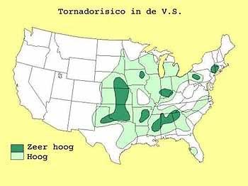
Tornado's ontstaan overal in de Verenigde Staten, maar het merendeel ten oosten van de Rocky Mountains in Texas, Kansas en Oklahoma, ook wel Tornado Alley genoemd. Jaarlijks razen ongeveer 1000 tornado's over de Verenigde Staten.
Er zijn twee tornadoseizoenen. De eerste is in april en mei en het tweede in november. In november beperken de tornado's zich tot Alabama, Mississippi en Louisiana.
Florida is berucht wegens het grote aantal onweersdagen. In Lightning Alley onweert het op meer dan 90 dagen per jaar.
vorige delen
Deel1: Weeralarm VS: Ongewoon zwaar tornadoseizoen
Deel2: Weeralarm V.S. #2 Extreem weer - Tornado touchdown!
enkele site's voor informatie
http://www.news9.com/
http://www.tornadovideos.net/
http://www.accuweather.com/news.asp
Amerikaanse weerinstituut National Weather Service
Voor orkanen is er: Hurricane Season 2010
Hagelstenen van een onweersbui bij Oklahoma City
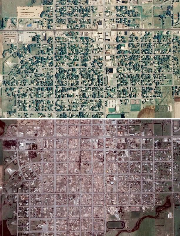
Foto Greensburg voor en na de Tornado Ramp
[ Bericht 5% gewijzigd door #ANONIEM op 17-05-2010 13:19:49 ]

De Verenigde Staten kennen extreme weersituaties. Tornado's en orkanen eisen elk jaar tientallen levens. Plotseling opkomende onweersbuien zijn vooral in Florida gevaarlijk. In bergachtige gebieden en in woestijnen neemt de grond weinig water op en veranderen beekjes als gevolg van hevige regenval plotseling in kolkende watermassa's.
Tornado's
Tornado's ontstaan overal in de Verenigde Staten, maar het merendeel ten oosten van de Rocky Mountains in Texas, Kansas en Oklahoma, ook wel Tornado Alley genoemd. Jaarlijks razen ongeveer 1000 tornado's over de Verenigde Staten.
Er zijn twee tornadoseizoenen. De eerste is in april en mei en het tweede in november. In november beperken de tornado's zich tot Alabama, Mississippi en Louisiana.
Florida is berucht wegens het grote aantal onweersdagen. In Lightning Alley onweert het op meer dan 90 dagen per jaar.
Nieuwsberichten, foto's, filmpjes over tornado's, onweer, overstromingen etc etc kun je hier in dit topic kwijt.quote:Tornado Parkersburg tweede EF5 van de eeuw
De tornado die zondagmiddag om 18 uur door Parkersburg in de stad Iowa trok is gedefinieerd als een EF-5 tornado. Daarmee is sprake van de tweede EF5-tornado van deze eeuw. De laatste keer dat dit gebeurde was op 4 mei 2007 in Greensburg (Kansas).
De tornado in Parkersburg was de zwaarste tornado voor Iowa sinds 1976. De tornado trok met windsnelheden van 328 kilometer per uur door het dorp en had een breedte van 800 meter. Daarbij vielen volgens de officiële statistiek van de Nationale Weerdienst 6 doden. 50 mensen raakten gewond.
vwk
vorige delen
Deel1: Weeralarm VS: Ongewoon zwaar tornadoseizoen
Deel2: Weeralarm V.S. #2 Extreem weer - Tornado touchdown!
enkele site's voor informatie
http://www.news9.com/
http://www.tornadovideos.net/
http://www.accuweather.com/news.asp
Amerikaanse weerinstituut National Weather Service
Voor orkanen is er: Hurricane Season 2010
Hagelstenen van een onweersbui bij Oklahoma City
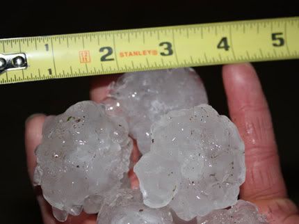
Foto Greensburg voor en na de Tornado Ramp
[ Bericht 5% gewijzigd door #ANONIEM op 17-05-2010 13:19:49 ]
http://www.news9.com/
Misschien deze link nog in de OP zetten. Newszender die er altijd bij is wanneer er tornado's in Oklahoma zijn. Heli's die naast tornado's vliegen etc
Misschien deze link nog in de OP zetten. Newszender die er altijd bij is wanneer er tornado's in Oklahoma zijn. Heli's die naast tornado's vliegen etc

Ik heb hem er tussen gezetquote:Op maandag 17 mei 2010 13:14 schreef Drassss het volgende:
http://www.news9.com/
Misschien deze link nog in de OP zetten. Newszender die er altijd bij is wanneer er tornado's in Oklahoma zijn. Heli's die naast tornado's vliegen etc
Ging snel ineens. Topic geopend in 2008.quote:Op maandag 17 mei 2010 14:29 schreef Frutsel het volgende:
[..]
Mooie OP
Deeltje 3 alweer... deel 2 liep ineens een stuk sneller
http://www.news9.com/Global/category.asp?C=116601&clipId=4793811&autostart=true
Nog even wat filmpjes van het hagelgeweld. Sorry voor het laffe Amerikaanse gezeik eromheen...
Nog even wat filmpjes van het hagelgeweld. Sorry voor het laffe Amerikaanse gezeik eromheen...
Nog wat beelden van de hagel:
1. http://www.zie.nl/video/o(...)elstorm/m1cziiafijuj
2.
[ Bericht 0% gewijzigd door i2Them2 op 18-05-2010 16:02:44 ]
1. http://www.zie.nl/video/o(...)elstorm/m1cziiafijuj
2.

[ Bericht 0% gewijzigd door i2Them2 op 18-05-2010 16:02:44 ]
The fuck, je auto zou maar buiten staanquote:Op dinsdag 18 mei 2010 14:53 schreef i2Them2 het volgende:
Nog wat beelden van de hagel:
http://www.zie.nl/video/o(...)elstorm/m1cziiafijuj
Op woensdag 21 maart 2012 19:42 schreef Drassss het volgende:
Ben ik de enige die steeds Sideboobie leest ipv van Sideshowbobbie
Ben ik de enige die steeds Sideboobie leest ipv van Sideshowbobbie
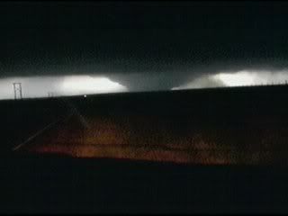
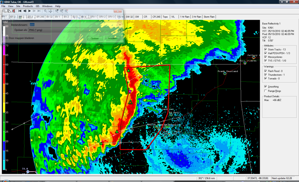
Tornado gebied gaat nu recht op het plaatsje Taloga af. Daar achter is nog een cel actief en die gaat op Lipscomb af.
Lipscomb krijgt nu een tornado warning. 2 cellen om het dorpje heen.
Andere cel ( 1,5 inch hagel ) is nu noord van Watonga en oostwaards aan het gaan
Andere cel ( 1,5 inch hagel ) is nu noord van Watonga en oostwaards aan het gaan
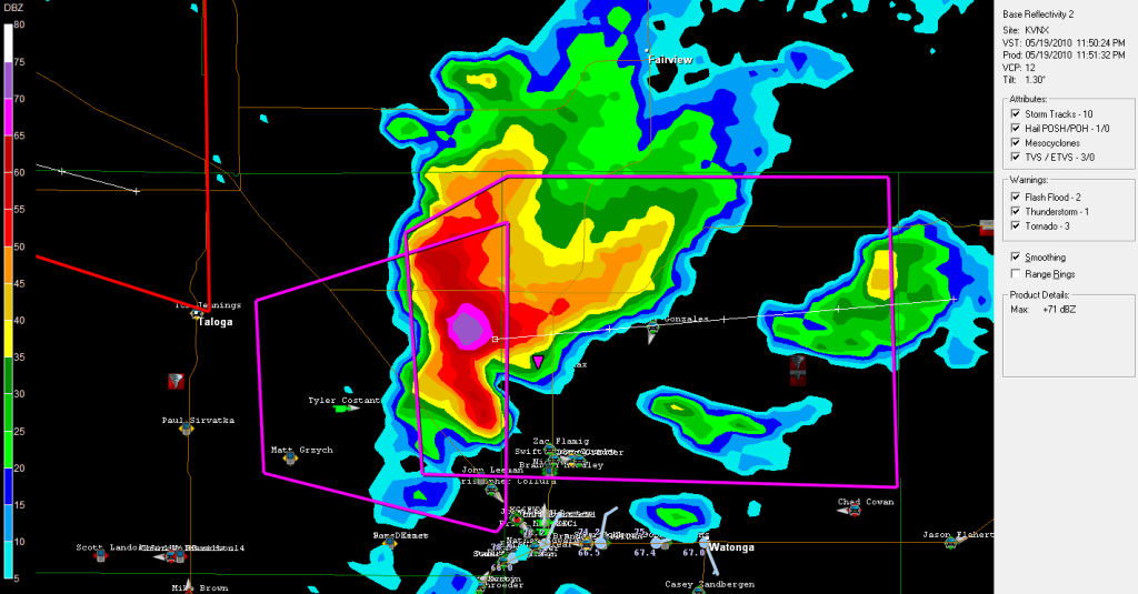
Zwaar deel met hagel van 2 inches gaat recht op Perry af. Hopelijk blijft het bij dit en gaat het geen tornado worden. Het is daar nu 6u sochtends....
Klopt, dat duurt nog wel eventjes, maar alles schuift langzaam richting Tulsa.
Edit: Alhoewel het iets noord van Tulsa lijkt te trekken.
Edit: Alhoewel het iets noord van Tulsa lijkt te trekken.

Leuk lijntje! Vooral op de plek waar de lijn zich lijkt te splitsen kans op een tornado of andere hevige windverschijnselen. Dit geldt ook voor het zuidelijkste punt.
OKLAHOMA CITY – Severe storms are rolling through northern Oklahoma this morning. and more severe weather is expected this afternoon.
The storms have been concentrated in north central Oklahoma this morning moving through the Enid and Ponca City areas. A severe thunderstorm watch is in effect for north central and northwestern Oklahoma until 10 a.m.
A strong system may produce severe storms Wednesday afternoon into Wednesday evening. The storms will likely begin to develop after 3 p.m.
The biggest threat with the storms will be large hail, damaging wind and tornadoes.
AddThis Social Bookmark Button
Weer heel wat gebeurd gisteravond zeg! En vanavond/vannacht high kans op severe weather...
Check dit dan. Hagelbui afgelopen zondag, bizar:
Check dit dan. Hagelbui afgelopen zondag, bizar:


's Avonds een man, overdags rustig an

Filmpje stond er al in. Dat zwembadquote:Op woensdag 19 mei 2010 19:04 schreef Burnie88 het volgende:
Weer heel wat gebeurd gisteravond zeg! En vanavond/vannacht high kans op severe weather...
Check dit dan. Hagelbui afgelopen zondag, bizar:
Tussen 00.00 en 03.00 onze tijd zal in OKC moderate risk van severe weather zijn. Kans op tornado's etc. Kan weer een zware dag voor Oklahoma worden..
OKLAHOMA CITY – Severe storms rolled through northern Oklahoma Wednesday morning and more severe weather is expected through this afternoon and into the evening.
The storms were concentrated in north central Oklahoma this morning moving through the Enid and Ponca City areas. A severe thunderstorm watch was in effect for north central and northwestern Oklahoma until 10 a.m.
A strong system may produce severe storms Wednesday afternoon into Wednesday evening. The storms will likely begin to develop after 3 p.m.
The biggest threat with the storms will be large hail, damaging wind and tornadoes.
[ Bericht 35% gewijzigd door Drassss op 19-05-2010 21:11:10 ]
Ze hebben nu al een county of 20 een watch gegeven in Oklahoma. Gaat echt een zware dag worden. Toch maar eens allemaal volgenquote:Op woensdag 19 mei 2010 22:00 schreef aloa het volgende:
Pittsburg krijgt het zo zwaar te verduren.
Er is nu wel een Tornado watch uitgegeven.
Echte uitbraak gaat over 40 min beginnen. Weermensen in Oklahoma verwachten toch wel een afschuwelijke dag... misschien nog erger dan vorige week maandag.
Correct, ziet er erg slecht uit.quote:Op woensdag 19 mei 2010 22:26 schreef Frutsel het volgende:
Oklahoma City ligt midden in het potentieel gevaarlijkste gebied?
http://www.news9.com/Global/category.asp?C=184600
Kan je live weather news zender volgen met Gary, en freaks die naast tornado's gaan vliegen/rijden.
Kan je live weather news zender volgen met Gary, en freaks die naast tornado's gaan vliegen/rijden.
Enid kan weer een hit krijgen van een cell die net op het scherm is gekomen.
Voor de warning in het westen van Oklahoma op dit moment.
Voor de warning in het westen van Oklahoma op dit moment.
Geen probleem Burnie.
Ja gaat echt al los en pas over 15 min zou het echt losgaan volgens weatherchannel.
Nu al 4 cellen actief met 2 warnings.
Edit: Vorig jaar vaak genoeg achter men televisie gezeten toen ik daar was
Ja gaat echt al los en pas over 15 min zou het echt losgaan volgens weatherchannel.
Nu al 4 cellen actief met 2 warnings.
Edit: Vorig jaar vaak genoeg achter men televisie gezeten toen ik daar was
De westelijk cel schijnt al even een tornado aan de grond te hebben. In ieder geval 10 minuten geleden nog wel. Ook al 2 inch hail trouwens.
Maar ben benieuwd hoe lang die cel het nog uit houdt. Inflow lijkt afgesneden te worden door een ander buitje.
Maar ben benieuwd hoe lang die cel het nog uit houdt. Inflow lijkt afgesneden te worden door een ander buitje.
Geweldige beelden vanuit die helikopter. Ik denk dat het voorlopig nog even wachten zal zijn totdat er wat gaat gebeuren. Deze cells zijn mooi, maar geen haak en rotatie. Wel mooie wallclouds 
's Avonds een man, overdags rustig an
Het lijkt er trouwens op dat de cells wat afzwakken. Helaas, morgenochtend weer werken, dus ik hou het voor gezien. Veel plezier vanavond en post wat mooie beelden/footages s.v.p.!
's Avonds een man, overdags rustig an


Die er net achter, west?quote:Op woensdag 19 mei 2010 23:52 schreef i2Them2 het volgende:
De grotere supercell iets naar het westen begint ook zijn krachten weer terug te krijgen. Ben benieuwd of die nog wat op de grond zet.
Tevens die cell noord van Lawton zit zal zo wat laten zien. Ook beginnende cellen oost van Oklahoma City.
Zal flink wat hagel in zitten waarschijnlijk. Verder een mooie cel.
Nadeel is wel dat er alweer buien ontstaan in het pad van de cel. Hierdoor zal de inflow waarschijnlijk weer wat afgesneden worden.
Nadeel is wel dat er alweer buien ontstaan in het pad van de cel. Hierdoor zal de inflow waarschijnlijk weer wat afgesneden worden.
Jep hij kan zomaar gaan afzwakken.
Let goed op de cell bij Lawton, dat kan echt een klapper gaan worden.
Let goed op de cell bij Lawton, dat kan echt een klapper gaan worden.
Ja die is prachtig. Daar kwam net de 1ste tornado uit.quote:Op donderdag 20 mei 2010 00:04 schreef i2Them2 het volgende:
Beeld van de andere cel. Zit een leuke haak aan.
[ afbeelding ]
Die cell idd in de gaten houden.quote:Op donderdag 20 mei 2010 00:04 schreef Drassss het volgende:
Jep hij kan zomaar gaan afzwakken.
Let goed op de cell bij Lawton, dat kan echt een klapper gaan worden.
Beeld van de beide noordelijke cellen dan maar.

Ja zit nu een thunderstorm warning op. Gelukkig woont in dat gebied echt niemand.quote:Op donderdag 20 mei 2010 00:14 schreef i2Them2 het volgende:
Nu ook een cel verder in het oosten ontstaan. Gaat zeer hard. Lijkt al een haak aan te zitten.

Ziekelijk nu. Overal zijn cellen, Stillwater krijgt nu een direct hit. Guthrie van een andere cell, zuid van OKC ook een aantal cellen. Niet te geloven dit.


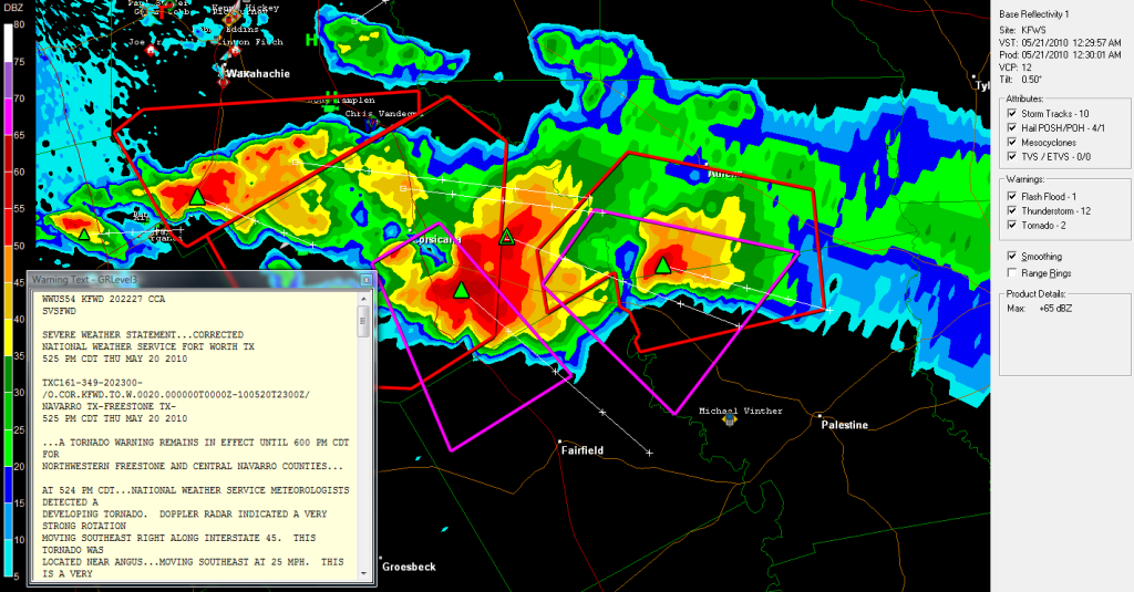
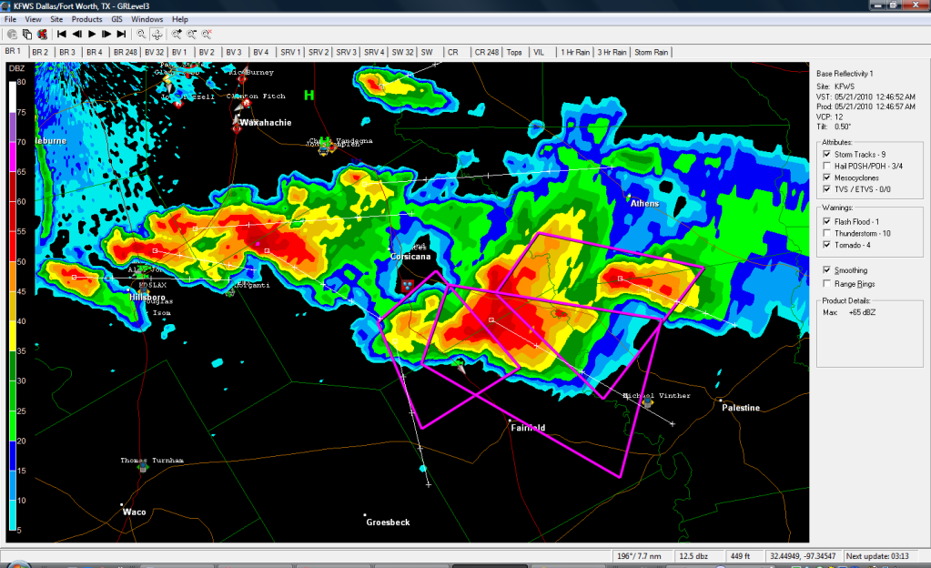
quote:Multiple Tornadoes Touch Down Across Oklahoma
OKLAHOMA CITY -- At least six tornadoes touched down across the state Wednesday.
The National Weather Service reported tornadoes in mostly sparsely populated areas of central and northern Oklahoma, although warnings extended as far south and east as the Oklahoma City and Tulsa metropolitan areas.
The National Weather Service reported tornadoes near Leedey in Dewey County, near Douglas in Garfield County, near Marshall in Logan County and near Loyal, Hennessey in Kingfisher County, and near Wynnewood in Garvin County.
Several areas reported large hail. One report was up to baseball size.
A very large tornado touched down around 4:40 and barely missed Hennessey. It was on the ground for at least six or seven minutes. The twister brushed closely to the west and northwest side of the city, but there are no reports of major damage. After it disappeared, another, smaller rope tornado briefly touched down from the same cloud.
SkyNEWS 9 HD also reported a tornado just south of Marshall.
The Kingfisher Fire Department reported power lines down in the area, just 2 miles west of Loyal. They also said an overturned semi was struck by a tornado about 2 miles south of Dover. Emergency management director Steve Loftis said the driver was taken to a nearby hospital with injuries that weren't considered life-threatening.
Power lines are down inside the city of Loyal. Damage was reported to one unoccupied trailer in a trailer park on the west side of Loyal. Residents have also said large trees have been uprooted in the area.
Residents reported major hail damage in Canton with broken windows and destroyed wheat fields.
Severe storms rolled through northern Oklahoma Wednesday morning. The storms were concentrated in north central Oklahoma this morning moving through the Enid and Ponca City areas. A severe thunderstorm watch was in effect for north central and northwestern Oklahoma until 10 a.m.
Authorities said at least one person was hurt as severe weather raked across northern Oklahoma Wednesday morning. Oklahoma Department of Emergency Management spokeswoman Michelann Ooten said a truck driver was injured when straight-line winds blew over a semi on Interstate 35 near Tonkawa. The driver was taken to a local hospital and his condition was not known, Ooten said. Two other semitrailers also were blown over on the interstate, she said.
The National Weather Service said at least three tornadoes may have touched down overnight Wednesday in far northwestern Oklahoma, including one near Arnett and two near Guymon.

Heb je daar nog (radar)beelden van?quote:Op donderdag 20 mei 2010 01:23 schreef Drassss het volgende:
Ziekelijk nu. Overal zijn cellen, Stillwater krijgt nu een direct hit. Guthrie van een andere cell, zuid van OKC ook een aantal cellen. Niet te geloven dit.
Spijt me die heb ik niet meer gemaakt. Cellen bij Stillwater en de west cell werden opeens 2x zo groot. Kijken of ik wat reports kan vinden van ze.quote:
Mag ik stellen dat het gisteren was tegenviel uiteindelijk? Wel mooie beelden trouwens! Bedankt voor de footage heren, leuk om terug te lezen
's Avonds een man, overdags rustig an
Qua tornado's viel het tegen, maar qua stormen die overal en nergens waren was het eigenlijk best ziek. Veelquote:Op donderdag 20 mei 2010 23:33 schreef Burnie88 het volgende:
Mag ik stellen dat het gisteren was tegenviel uiteindelijk? Wel mooie beelden trouwens! Bedankt voor de footage heren, leuk om terug te lezen
grote steden werden getroffen. Ik hoop nog wat amerikanen te spreken, misschien weten ze nog iets meer.
http://www.news9.com/Global/category.asp?C=116601&clipId=4801312&topVideoCatNo=118433&autoStart=true
Stillwater kreeg echt een direct hit, ook een aantal steden zuid van OKC ( Moore/Norman ).
Nu iets van een haak. Verder wordt er gesproken over een funnelcloud. Naast deze tornado warning staat er ook nog een warning uit in Missouri. Die cel is wel wat minder spectaculair.
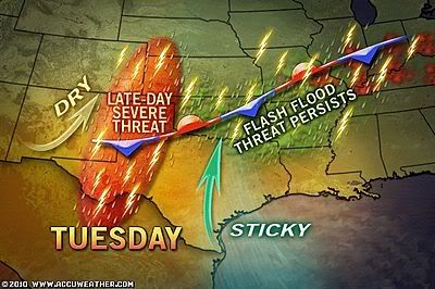
quote:Severe storms to rattle Michigan to West Texas
.Severe storms will ignite over a large part of the Plains by later today and tonight, threatening lives and property. The strongest storms could spawn tornadoes.
From northern Ontario, Canada, and northern Michigan to West Texas, some severe storms will erupt along the collision of steamy air surging from the Gulf of Mexico and less humid air farther west. A new storm arriving in the High Plains by tonight will trigger intense storms that rattle portions of the Plains.
Places at risk for severe storms include: Green Bay, Wis., Minneapolis, Minn., Omaha, Neb., to Goodland and Liberal, Kan., Roswell, N.M., and Lubbock, Texas.
Severe Storm Threats Today and Tonight
Hail larger than quarters and even golf balls, damaging wind gusts over 60 mph, and a few tornadoes will threaten to cause damage. Trees and power lines will be downed, littering some communities, while structural damage to homes and businesses will be a possibility.
Flash flooding could force some roads to be closed where the heaviest downpours are unleashed.
Along a cold front that sparked severe storms in the Dakotas on Saturday, some severe storms will develop during the afternoon over southern Minnesota, northern Iowa, western Wisconsin and western portions of the Upper Peninsula of Michigan.
These storms will shift farther east and become more sparse by the overnight hours.
Farther to the south, a few isolated, severe storms will erupt from West Texas to southwestern Iowa, during the peak warm afternoon hours.
Storms in the central and southern Plains, especially in eastern Colorado, western Kansas, the Oklahoma Panhandle and northern portions of the Texas Panhandle, will become more widespread and violent into the late evening and overnight hours. This will happen as a storm system over the Four Corners region advances northeastward toward the High Plains.
The most violent storms will shift northward into Nebraska and southern South Dakota by the early morning hours.
Severe Storms to Ignite Over Length of Plains Again Monday
Potentially damaging severe storms will fire from central Minnesota to West Texas again on Monday along the cold front of a storm arriving in the northern Plains.
Storms will be capable of producing more tornadoes, large hail and damaging wind gusts.


Dat 2e filmpje is inderdaad geweldig. Gewoon een EF4 terwijl er geen high risk was o.i.d.
's Avonds een man, overdags rustig an
Inmiddels gaan we weer los. Al 3 weather watches, een paar supercells aan het ontwikkelen. Moderate Risk.
's Avonds een man, overdags rustig an
Live beelden van een tornado
http://www.severestudios.com/cgi-bin/player-full.pl?username=john.wetter&uid=84
http://www.severestudios.com/cgi-bin/player-full.pl?username=john.wetter&uid=84


Het was gisteravond/vannacht weer een chaos in de VS, nu vooral in het noorden. Al 46 tornado's bevestigd waaronder een aantal fatale... Ook zijn er een aantal dorpen heftig beschadigd wat toch wel duidt op de wat grotere tornado's. Beelden zullen vast en zeker snel beschikbaar zijn.
's Avonds een man, overdags rustig an
Hmm ik zal eens wat rondkijken op wat sites. Misschien vind ik wat.quote:Op zondag 6 juni 2010 10:25 schreef Burnie88 het volgende:
Het was gisteravond/vannacht weer een chaos in de VS, nu vooral in het noorden. Al 46 tornado's bevestigd waaronder een aantal fatale... Ook zijn er een aantal dorpen heftig beschadigd wat toch wel duidt op de wat grotere tornado's. Beelden zullen vast en zeker snel beschikbaar zijn.
4 Doden door het noodweer, 50 huizen vernietigd
quote:4 killed in heavy storms sweeping through Midwest
By JOHN SEEWER (AP) – 34 minutes ago
MILLBURY, Ohio — Tornados and thunderstorms that swept through the Midwest overnight killed at least four people in Ohio, sent several to hospitals, destroyed 50 homes and damaged scores more, as well a high school gymnasium where graduation was to be held Sunday.
Authorities in northwest Ohio are still searching through homes and couldn't say whether anyone else is missing, Lake Township Fire Chief Todd Walters said. Walters flew over the damage Sunday morning and estimates the storm left an eight-mile path of destruction in a straight line over an area of farm fields and light industry. The storm narrowly missed the heavily populated suburbs on southern edge of Toledo.
A township police and emergency medical services building looked to be a total loss. The storm ripped off most of the building's back half, tossing a car into where the building once stood, now a mishmash of 2-by-4 beams and insulation strewn about. A patrol car nearby was flattened.
All the emergency dispatchers and 911 operators had to be moved to a nearby town.
"It's unbelievable," Walters said. "It's just total destruction — stuff just completely flattened or gone."
Lake Township High school was also among the hardest hit buildings. The field house was damaged and the cafeteria was destroyed, Superintendent Jim Witt said, and some buses were flung across the school parking lot.
In central Illinois, the National Weather service confirmed reports of a tornado touching down 80 to 100 miles southwest of Chicago, meteorologist Charles Mott said. He did not have further details.
Waar gezien Frutsel? Ja het was echt heftig... Nu ook aan de oostkust moderate risk...
's Avonds een man, overdags rustig an


Bij Fox en CNN had wat flarden ,zit nu op internet te zoekenquote:
Waar gezien Frutsel? Ja het was echt heftig... Nu ook aan de oostkust moderate risk...
Jezus hee. Die foto's van hierboven duiden toch zeker wel op een EF3 of EF4... Heftig zeg.
's Avonds een man, overdags rustig an
quote:Three dead after tornadoes rip through Midwest
Tornadoes and thunderstorms tore through the U.S. Midwest on Sunday, killing at least three people in Ohio and triggering the automatic shutdown of a nuclear power plant in Michigan.
U.S.
In northwest Ohio, where three people were confirmed dead in mostly rural Lake Township south of Toledo, tornadoes destroyed a dozen homes and partially demolished the police headquarters and high school, authorities said.
An emergency command center was set up behind the damaged police administration building, and the school's graduation ceremony was postponed.
"Windows were blown out of the buildings, buses overturned, the police department lost all of their vehicles except the ones that were occupied by officers," said a police spokesman in a neighboring township where calls were re-routed.
Severe storms caused the automatic shutdown of the Fermi 2 nuclear power plant on the shore of Lake Erie in southeast Michigan after a key area of the plant lost its power feed, said Monroe County spokesman Dan Smith.
All safety systems at the plant were functioning and the plant was stable, although an exterior wall was slightly damaged, Smith said.
Tornadoes also touched down in several locations in central Illinois around Peoria, the National Weather Service said. Local media reported dozens of injuries and damaged buildings.
Vanmorgen waren er nog tornado warnings/watches afgegeven van dat gebied, trekkend naar het oosten. Ik heb helaas alleen goede bronnen van de staat Oklahoma dus geen extra info van mij.
Behoorlijk front trekt nu Oklahoma in en verschillende thunderstorm warnings zijn al afgegeven. Ik ga er eigenlijk vanuit dat daar geen tornado's uitkomen.

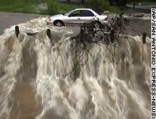
http://www.rtl.nl/(/actue(...)oelen-camping-vs.xmlquote:Doden door wegspoelen camping VS
Op een camping in Amerika zijn zeker 16 mensen verdronken door een plotselinge overstroming. Reddingsdiensten proberen de overige vakantiegangers te bereiken. Dat meldden Amerikaanse media.
Honderden campinggasten werden in hun slaap verrast. Tientallen mensen worden nog vermist. In korte tijd viel tot 15 centimeter regen in een bij toeristen populair wandelgebied.
De reddingsdiensten proberen met helikopters de vermisten op te sporen. Ook medewerkers van het Rode Kruis en leden van de National Guard zijn ingezet.
Dodental is opgelopen naar 18
http://www.trouw.nl/nieuw(...)kansas_loopt_op.htmlquote:Dodental camping Arkansas loopt op
CHICAGO (ANP) - Het aantal doden door de overstroming van een camping in de Amerikaanse staat Arkansas is opgelopen tot zeker achttien. Dit hebben de autoriteiten van de staat zaterdag (plaatselijke rijd) laten weten.
Zeker drie mensen worden nog vermist. Onder de slachtoffers zijn kinderen.
In korte tijd viel in de nacht van donderdag op vrijdag tot 15 centimeter regen in een populair gebied voor vissers, wandelaars en mountainbikers vlak bij de rivieren de Caddo en Little Missouri. Honderden gasten van de Albert Pikecamping in de Ouachitabergen ten westen van Little Rock, de hoofdstad van Arkansas, werden in hun slaap verrast.

quote:Op maandag 14 juni 2010 15:56 schreef Drassss het volgende:
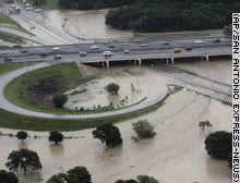
Momenteel zware overstromingen in Oklahoma City area.
quote:Oklahoma City Threatened by More Flooding
Following Monday's deluge of Oklahoma City that left homes under water and kept fire department crews busy with water rescues, more rounds of thunderstorms could lead to even more flooding in Oklahoma City and other areas of the southern Plains through tonight.
Dry weather will return to much of Oklahoma by midweek, but rounds of afternoon storms will continue erupting over areas farther east that have also endured recent flooding rain.
Continued Flooding Threat in the Southern Plains
A stationary front that was the focal point for the heavy, slow-moving storms on Monday, remains in place across the southern Plains. The front will once again be the trigger for torrential downpours today into tonight.
rest van verhaal
[ Bericht 54% gewijzigd door #ANONIEM op 15-06-2010 13:40:35 ]
Ja ik hoorde van vrienden daar dat hoofdwegen en vooral de binnenwegen amper begaanbaar zijn. Iets van 10 inches aan regen gevallen in 1 dag. Ongelofelijk.
En er komt nog meer aan.quote:Op dinsdag 15 juni 2010 13:43 schreef Drassss het volgende:
Ja ik hoorde van vrienden daar dat hoofdwegen en vooral de binnenwegen amper begaanbaar zijn. Iets van 10 inches aan regen gevallen in 1 dag. Ongelofelijk.
Big storm capable of producing a possible tornado Central Illinois aldus Twitter
http://radar.weather.gov/Conus/centgrtlakes_loop.php
http://radar.weather.gov/Conus/centgrtlakes_loop.php

Ik vrees dat het vannacht echt een hel gaat worden in de Midwest. Zware onweersbuien (geïsoleerd, maar ook geclusterd) die tornado's voortbrengen. En dat 's nachts! Dus dan krijg je toestanden als toen in Greensburg... Morgenmiddag en avond ook hoge kans op tornado's.
Vannacht:
Middag - Avond:
Vannacht:

Middag - Avond:

's Avonds een man, overdags rustig an
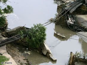
Dambreuk in Iowa
In de Amerikaanse staat Iowa heeft een dam het begeven, waardoor een enorme waterstroom omwonenden op de vlucht jaagt. De Lake Delhi-dam, zo'n 70 kilometer ten noorden van Cedar Rapids, kon de druk van het water niet meer aan na een ongewoon overvloedige regenval.
De 700 inwoners van Hopkin hadden welgeteld vijf minuten om zich uit de voeten te maken, meldt CNN. Er geldt ook overstromingsgevaar in het dorp Monticello, maar er zijn geen meldingen van slachtoffers. De bewoners waren al vroeg gewaarschuwd voor een eventuele dambreuk.
bron


http://forum.fok.nl/forum/134quote:Op zondag 25 juli 2010 13:00 schreef Frutsel het volgende:
Had wel eigen topic gemogen, dat van die dam
Storm legt delen New York lam
NEW YORK - Een flinke storm heeft donderdagavond (lokale tijd) delen van New York lamgelegd. Eén persoon kwam om het leven, 30.000 huishoudens kwamen zonder stroom te zitten en vliegvelden meldden forse vertragingen, aldus autoriteiten vrijdag.
Storm in New Yorkslideshow De storm verraste de miljoenenstad tijdens de avondspits, zeggen meteorologen. Er werden zelfs tornadowaarschuwingen voor Brooklyn en Queens afgegeven. Dat is zeer ongebruikelijk in deze regio.
Door de storm liep het verkeer in de New Yorkse straten vast. Door windvlagen van 130 kilometer per uur waaiden vrachtwagens en bomen om.
Vliegvelden
De politie adviseerde mensen om thuis te blijven. Op zowel de vliegvelden La Guardia en Newark hadden vluchten uren vertraging. Ook op het spoor liepen de vertragingen fors op.
Het slechte weer trok later de Atlantische Oceaan op.
nu.nl


Hoe groot is de kans dat we zoiets in Nederland zien? Ik weet dat we hier af en toe ook een supercel over zien drijven, maar ook zulke grote?

Het probleem is dat daar zoveel energie zit. Die Jetstream is daar ook ongelofelijk, zodat het daar de normaalste zaak van de wereld is... Achja dit jaar hebben we toch 1 flinke klapper gehad.quote:Op dinsdag 21 september 2010 21:40 schreef Disorder het volgende:
Hoe groot is de kans dat we zoiets in Nederland zien? Ik weet dat we hier af en toe ook een supercel over zien drijven, maar ook zulke grote?
Nieuw hagel record in Kansas
De hagelsteen (zie foto's hieronder), die op 15 september rond 18 uur in de buurt van Pawnee en 119e Street in West Wichita viel, kan de grootste hagelsteen ooit zijn die in de staat Kansas gevallen is. De hagelsteen had een diameter van 19.7 centimeter en een omtrek van 39.4 centimeter. De hagelsteen woog ongeveer 0.6 kilo. De omtrek en het gewicht werden officieel gemeten 15 uur nadat de hagelsteen viel. Het vorige record stond op naam van Coffeyville. Daar werd destijds (op 3 september 1970) een hagelsteen van 14.5 centimeter in diameter gemeten en had een omtrek van 44.6 centimeter.
© onweer-online
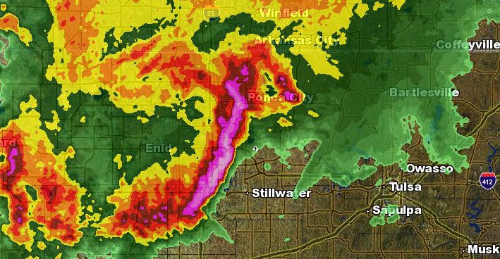
Radar image at 549 pm. Baseball and larger hail was occurring in the dark pink and purple areas.
Radar image of a supercell moving into Cowley County and two in Greenwood County.
Radar image of doppler wind velocities. Strong rotation occurs where bright red and green are close together. One supercell is north of Winfield and two are in Greenwood County.
Radar image of a supercell in Greenwood County.
Radar image of velocity showing the strong rotation on between Severy and Climax in Greenwood County.
Radar image of the bow echo as it approached Labette County with strong straight line wind damage.
Radar image of velocity of the bow echo as it approached Labette County. The bright colored red shows the strongest wind speeds approaching Labette County.
Summary of Most Significant Severe Reports
Large Hail:
•7.75 Inch hail near Pawnee and 119th, Wichita
•Multiple reports of grapefruit sized hail (4 Inches)
•Multiple reports of baseball sized hail (2.75 inches)
Tornadoes:
•7 miles west of Derby, Sedgwick County
•6 miles east of Clearwater, Sedgwick County
•1 mile east of Mulvane, Sumner County
•2 miles north-northwest of Severy, Greenwood County
•8 miles north of Winfield, Cowley County
•3 miles northwest of Burden, Cowley County
Damaging Wind:
•80 MPH (estimated) in Winfield, Cowley County
•76 MPH (measured) in Mulvane, Sumner County
•72 MPH (measured) in Cherryvale, Montgomery County
•70 MPH (estimated) in Fredonia, Wilson County
•66 MPH (measured) in Parsons, Labette County
Het volledige rapport is op deze link te vinden:
http://www.crh.noaa.gov/n(...)oryid=57687&source=0
http://test.crh.noaa.gov/ict/?n=91510stormreports
De hagelsteen (zie foto's hieronder), die op 15 september rond 18 uur in de buurt van Pawnee en 119e Street in West Wichita viel, kan de grootste hagelsteen ooit zijn die in de staat Kansas gevallen is. De hagelsteen had een diameter van 19.7 centimeter en een omtrek van 39.4 centimeter. De hagelsteen woog ongeveer 0.6 kilo. De omtrek en het gewicht werden officieel gemeten 15 uur nadat de hagelsteen viel. Het vorige record stond op naam van Coffeyville. Daar werd destijds (op 3 september 1970) een hagelsteen van 14.5 centimeter in diameter gemeten en had een omtrek van 44.6 centimeter.

© onweer-online

Radar image at 549 pm. Baseball and larger hail was occurring in the dark pink and purple areas.

Radar image of a supercell moving into Cowley County and two in Greenwood County.

Radar image of doppler wind velocities. Strong rotation occurs where bright red and green are close together. One supercell is north of Winfield and two are in Greenwood County.

Radar image of a supercell in Greenwood County.

Radar image of velocity showing the strong rotation on between Severy and Climax in Greenwood County.

Radar image of the bow echo as it approached Labette County with strong straight line wind damage.

Radar image of velocity of the bow echo as it approached Labette County. The bright colored red shows the strongest wind speeds approaching Labette County.
Summary of Most Significant Severe Reports
Large Hail:
•7.75 Inch hail near Pawnee and 119th, Wichita
•Multiple reports of grapefruit sized hail (4 Inches)
•Multiple reports of baseball sized hail (2.75 inches)
Tornadoes:
•7 miles west of Derby, Sedgwick County
•6 miles east of Clearwater, Sedgwick County
•1 mile east of Mulvane, Sumner County
•2 miles north-northwest of Severy, Greenwood County
•8 miles north of Winfield, Cowley County
•3 miles northwest of Burden, Cowley County
Damaging Wind:
•80 MPH (estimated) in Winfield, Cowley County
•76 MPH (measured) in Mulvane, Sumner County
•72 MPH (measured) in Cherryvale, Montgomery County
•70 MPH (estimated) in Fredonia, Wilson County
•66 MPH (measured) in Parsons, Labette County
Het volledige rapport is op deze link te vinden:
http://www.crh.noaa.gov/n(...)oryid=57687&source=0
http://test.crh.noaa.gov/ict/?n=91510stormreports
Weer of geen weer, altijd actueel www.onweer-online.nl
Niet normaal zo groot.quote:
Je zal 'm maar op je kop krijgen.
De V.S. is echt het land waar alles kan, wat weer betreft.
[ Bericht 75% gewijzigd door #ANONIEM op 21-09-2010 22:15:50 ]


Nooit dus?quote:Op dinsdag 21 september 2010 21:47 schreef Drassss het volgende:
[..]
Het probleem is dat daar zoveel energie zit. Die Jetstream is daar ook ongelofelijk, zodat het daar de normaalste zaak van de wereld is... Achja dit jaar hebben we toch 1 flinke klapper gehad.
Zoals in de VS dat je afschuwelijke tornado's krijgt? Dat nooit denk ik.quote:
Maar wees blij, dat wil je echt niet meemaken.
Nee, ik bedoelde dus of we ooit zulke mooie supercellen als in mijn youtube filmpje krijgen te zien hier. Van dat formaat dus..quote:Op woensdag 22 september 2010 07:51 schreef Drassss het volgende:
[..]
Zoals in de VS dat je afschuwelijke tornado's krijgt? Dat nooit denk ik.
Maar wees blij, dat wil je echt niet meemaken.
quote:More Severe Storms, Flooding to Pummel Kansas to Wisconsin
Areas from south-central Kansas to northern Wisconsin are at risk for severe storms that threaten to cause damage and flooding today.
A storm system cutting from the central Plains into the upper Great Lakes will be the culprit behind the violent weather, while moisture from the remnant low of Georgette adds to the risk of flooding across portions of the Plains and the Midwest.
Severe Storm Threat Today
Concerns with today's thunderstorms will be very large hail, locally damaging wind gusts, flooding downpours and isolated tornadoes.
Hail bigger than golf balls threaten to crack windshields and damage crops, while the strong wind gusts can topple trees and power lines in some communities.
Flash flooding of urban, low-lying and poor drainage areas is likely with the heavy downpours that develop. Motorists are urged to avoid driving over roadways covered by water, since that could be a life-threatening decision.
The heavy rain associated with dangerous storms will be visible on the Omaha Radar, the Wichita Radar, and the Minneapolis Radar as the day progresses.
Severe thunderstorms will shift eastward overnight, putting Kansas City, Mo., Des Moines, Iowa, and Madison, Wis., in the line of fire.
To the north of the battlegrounds for storms, a steadier, windswept rain will be unleashed across the northern Plains and the Upper Great Lakes region. Aberdeen, S.D., International Falls, Minn., and and Marquette, Mich., may deal with flooding.
Up to 4 inches of rain will soak the Dakotas to the Upper Peninsula of Michigan with the shield of rain.
Severe Storms Hit the Plains on Wednesday
Severe thunderstorms rumbled from central Nebraska to southern Minnesota on Wednesday, producing very large window-breaking hail, gusty winds, and flooding rainfall.
Hail up to the size of baseballs and even softballs fell in a few areas. Hail of 4.25 inches in diameter pounded an area 1 mile to the south of Crofton, Neb.
Flash flooding resulted 2-4 inches of rain that poured down from central Nebraska to southern Minnesota with Wednesday's thunderstorms. Some highways have been left under water and many homes have endured flooding in this corridor.
Accuweather


Tornadowaarschuwing voor New York
Het Amerikaanse National Weather Service heeft dinsdagochtend (lokale tijd) een tornadowaarschuwing uitgegeven voor onder andere de stad New York
De waarschuwing blijft in ieder geval van kracht tot zes uur dinsdagavond (lokale tijd) en geldt onder andere voor de wijken Bronx en Queens, maar ook voor andere delen van de staat New York.
Het instituut acht overstromingen als gevolg van hevige regenval mogelijk. Bovendien worden er windsnelheden tot 120 kilometer per uur verwacht en is er kans op zware onweersbuien.
De waarschuwing wordt uitgegeven terwijl veel wijken en steden nog bezig zijn met het herstellen van de schade als gevolg van het noodweer op 17 september, dat delen van New York lam legde.
http://www.nu.nl/buitenla(...)huwing-new-york.html
Life is Music

Tornado Intercept radardata - TVN
De heren van tornadovideos.net hebben vandaag voor het eerst een dataset met verticale windsnelheden vrijgegeven. De dataset bevat de eerste geslaagde metingen met de radar die bovenop de dominator staat. De getoonde snelheden zijn gemeten tijdens een intercept van een multivortex F4 tornado op 17 juni 2010 ten zuidwesten van Wadena MN.
Onderstaand is een overzicht van de gemeten verticale windsnelheden, op z'n top bereikte deze 170 mph (~275 km/u). Op datzelfde moment werden er windstoten tot 300 km/u gemeten door de windmeter op de dominator. In de grafiek is de horizontale balk de tijd in seconden en de verticale balk is de verticale windsnelheid.
Een absolute aanrader zijn de onderstaande beelden. Deze geven een goed beeld van de tornado waarin deze windsnelheden zijn gemeten. De intercept zelf is op deze beelden niet te zien, deze zullen te zijn zijn tijdens het nieuwe seizoen van Stormchasers, welke 13 oktober in premiere gaat in de VS. De verwachting is dat Stormchasers aan het eind van dit jaar of begin volgend jaar in Nederland word uitgezonden. Een exacte datum volgt nog
Enjoy!
©onweer-online
De heren van tornadovideos.net hebben vandaag voor het eerst een dataset met verticale windsnelheden vrijgegeven. De dataset bevat de eerste geslaagde metingen met de radar die bovenop de dominator staat. De getoonde snelheden zijn gemeten tijdens een intercept van een multivortex F4 tornado op 17 juni 2010 ten zuidwesten van Wadena MN.
Onderstaand is een overzicht van de gemeten verticale windsnelheden, op z'n top bereikte deze 170 mph (~275 km/u). Op datzelfde moment werden er windstoten tot 300 km/u gemeten door de windmeter op de dominator. In de grafiek is de horizontale balk de tijd in seconden en de verticale balk is de verticale windsnelheid.

Een absolute aanrader zijn de onderstaande beelden. Deze geven een goed beeld van de tornado waarin deze windsnelheden zijn gemeten. De intercept zelf is op deze beelden niet te zien, deze zullen te zijn zijn tijdens het nieuwe seizoen van Stormchasers, welke 13 oktober in premiere gaat in de VS. De verwachting is dat Stormchasers aan het eind van dit jaar of begin volgend jaar in Nederland word uitgezonden. Een exacte datum volgt nog
Enjoy!
©onweer-online

Weer of geen weer, altijd actueel www.onweer-online.nl

Steam Devils
Andrew Pritchard
Image taken: Oct. 3, 2010 Location: Deep Lake, Oxford, Wisconsin, USA
Details:
While at the lake house in central Wisconsin during the area's first hard freeze, temperatures plunged to at or below 30F. With water temperatures in the lake still above 60F, I figured photogenic morning steam would be a sure thing. I ended up with that and more, as steam devils, or little vortices in the steam started sprouting up around sunrise. Essentially these guys form under the same conditions that drive dust devils, as well as water spouts and land spout tornadoes, on a much much smaller scale of course. Little areas of vorticity would be present as the very light winds roll the steam across the lake surface, while little updrafts due to the instability in the lowest of levels stretches the vorticity into at times tight little circulations in the steam. Pretty mesmerizing stuff to watch as they really do resemble little water spouts. I ended up almost core punching one on the row boat just after sunrise and noticed they even created little "swirl" regions at the surface of the water and base of the vortex, exactly as water spouts do. Unfortunately this was too difficult to actually document visually. Video as well:


<a href="http://www.vwkweb.nl/" rel="nofollow" target="_blank">Vereniging voor weerkunde en klimatologie</a>
<a href="http://www.estofex.org/" rel="nofollow" target="_blank">ESTOFEX</a>
<a href="http://www.estofex.org/" rel="nofollow" target="_blank">ESTOFEX</a>
Momenteel tornado warning in Arizona omgeving; Flagstaff.
Edit: 1 tornado is ook al confirmed
[ Bericht 31% gewijzigd door Drassss op 06-10-2010 16:56:04 ]

Edit: 1 tornado is ook al confirmed
[ Bericht 31% gewijzigd door Drassss op 06-10-2010 16:56:04 ]
Tornado warnings are in effect for Flagstaff, Sedona/Oak Creek Canyon and the area south of Tuba City.
BELLEMONT, Ariz. -- The National Weather Service has confirmed that two tornadoes touched down in the area of Interstate 40 between mileposts 180 and 190 west of Flagstaff Wednesday morning.
"That confirmation came because the tornado passed almost directly over our office here in Bellemont," said Dan LeBlanc of the National Weather Service.
The first hit Bellemont around 5:30 a.m. and the second touched down east of the small community about 45 minutes later. That's the one that passed by the NWS office. Damage to homes in the area is extensive with smashed windows and siding torn off some residences. Between 10 and 15 home are uninhabitable. Seven people reportedly were injured, but those injuries were not serious. No fatalities or missing persons have been reported.
The Red Cross is setting up a reception center at Flagstaff Middle School for some 30 people who have been displaced. That shelter should be operational by noon.
The Department of Public Safety reported several collisions in that area. No serious injuries were reported in those wreck. I-40 was closed for a time from Parks to the A-1 interchange, roughly milepost 170 to 190.
As of 10:15 a.m., Arizona Department of Transportation spokesman Doug Nintzel said I-40 was open between Flagstaff and Williams. Debris, however, was a major issue on several highways and roadways in the Flagstaff area, causing some significant backups. Drivers were being urged to go slowly and exercise extreme caution. DPS is advising people to avoid the area if possible. Crews were working to clear that debris. Intermittent closures are possible throughout the day.
According to Lena Kent off Burlington Northern Santa Fe, the severe weather up north derailed a 58-car train. One of the tornadoes blew 28 cars off the tracks. A crew of two was aboard the train at the time. Neither was hurt. The train, which was stopped in Bellemont because of the tornado warning, was heading east, hauling containerized cargo from ports in Los Angeles. It was not carrying any hazardous materials. Both the eastbound and westbound tracks are closed. Kent said crews are working to clear the tracks and expect to have them back open by midnight.
At the Camping World RV Park in Bellemont, some 30 RVs were blown over and the debris was scattered all over I-40.
DPS said a third tornado did hit the area, but the NWS has not yet confirmed that.
A tornado warning for central Coconino and northeastern Yavapai Counties, including Bellemont, expired at 8:15 a.m. Radar continues to show several super cells thunderstorms in central and north central Arizona capable of producing tornadoes with little or no advance notice, moving north-northeastward at approximately 50 mph.
Three new warnings were issued for Flagstaff, Sedona/Oak Creek Canyon and the area south of Tuba City shortly after 11 a.m. as a line of severe thunderstorms developed from east of Prescott to north to Bellemont and the Parks area.
The severe weather is expected to continue through Wednesday afternoon. A tornado watch continues for central and north-central Arizona until 5 p.m.
The Red Cross said it is on standby should a tornado touch down in Flagstaff.
A citizen hotline has been activated for the public to obtain information and updates about the emergency. The number is 1-888-679-8393.
In addition, an emergency operations center has been set up at the Sheriff’s Office in Flagstaff.
The Associated Press contributed to this report.
http://www.azfamily.com/w(...)staff-104414284.html
[ Bericht 1% gewijzigd door Drassss op 06-10-2010 20:44:57 ]
BELLEMONT, Ariz. -- The National Weather Service has confirmed that two tornadoes touched down in the area of Interstate 40 between mileposts 180 and 190 west of Flagstaff Wednesday morning.
"That confirmation came because the tornado passed almost directly over our office here in Bellemont," said Dan LeBlanc of the National Weather Service.
The first hit Bellemont around 5:30 a.m. and the second touched down east of the small community about 45 minutes later. That's the one that passed by the NWS office. Damage to homes in the area is extensive with smashed windows and siding torn off some residences. Between 10 and 15 home are uninhabitable. Seven people reportedly were injured, but those injuries were not serious. No fatalities or missing persons have been reported.
The Red Cross is setting up a reception center at Flagstaff Middle School for some 30 people who have been displaced. That shelter should be operational by noon.
The Department of Public Safety reported several collisions in that area. No serious injuries were reported in those wreck. I-40 was closed for a time from Parks to the A-1 interchange, roughly milepost 170 to 190.
As of 10:15 a.m., Arizona Department of Transportation spokesman Doug Nintzel said I-40 was open between Flagstaff and Williams. Debris, however, was a major issue on several highways and roadways in the Flagstaff area, causing some significant backups. Drivers were being urged to go slowly and exercise extreme caution. DPS is advising people to avoid the area if possible. Crews were working to clear that debris. Intermittent closures are possible throughout the day.
According to Lena Kent off Burlington Northern Santa Fe, the severe weather up north derailed a 58-car train. One of the tornadoes blew 28 cars off the tracks. A crew of two was aboard the train at the time. Neither was hurt. The train, which was stopped in Bellemont because of the tornado warning, was heading east, hauling containerized cargo from ports in Los Angeles. It was not carrying any hazardous materials. Both the eastbound and westbound tracks are closed. Kent said crews are working to clear the tracks and expect to have them back open by midnight.
At the Camping World RV Park in Bellemont, some 30 RVs were blown over and the debris was scattered all over I-40.
DPS said a third tornado did hit the area, but the NWS has not yet confirmed that.
A tornado warning for central Coconino and northeastern Yavapai Counties, including Bellemont, expired at 8:15 a.m. Radar continues to show several super cells thunderstorms in central and north central Arizona capable of producing tornadoes with little or no advance notice, moving north-northeastward at approximately 50 mph.
Three new warnings were issued for Flagstaff, Sedona/Oak Creek Canyon and the area south of Tuba City shortly after 11 a.m. as a line of severe thunderstorms developed from east of Prescott to north to Bellemont and the Parks area.
The severe weather is expected to continue through Wednesday afternoon. A tornado watch continues for central and north-central Arizona until 5 p.m.
The Red Cross said it is on standby should a tornado touch down in Flagstaff.
A citizen hotline has been activated for the public to obtain information and updates about the emergency. The number is 1-888-679-8393.
In addition, an emergency operations center has been set up at the Sheriff’s Office in Flagstaff.
The Associated Press contributed to this report.
http://www.azfamily.com/w(...)staff-104414284.html


[ Bericht 1% gewijzigd door Drassss op 06-10-2010 20:44:57 ]


quote:4 tornado's treffen Arizona op één dag
De Amerikaanse staat Arizona werd gisteren op één dag tijd door liefst vier tornado's getroffen. De wervelwinden richtten over de gehele staat aanzienlijke schade aan.
De tornadozwerm is een zeldzaam fenomeen in Arizona. Normaal krijgt de staat op een heel jaar slechts van hooguit vier tornado's bezoek. Gisteren was dus een bijzondere dag in Arizona, met liefst 22 waarschuwingen voor extreme weersomstandigheden. Gelukkig vielen er geen dodelijke slachtoffers, al hebben de stormen wel veel huizen en auto's vernield.
De inwoners van Bellemont werden geëvacueerd en zeker 30 huizen werden zwaar beschadigd door de storm. Een camping nabij de Interstate 40 werd eveneens niet gespaard. Tientallen kampeerwagens werden ondersteboven geblazen. Brokstukken vlogen de baan op, met zware files tot gevolg. Ook treinen ontspoorden door de tornado's.
De tornado's zijn het gevolg van een actief weersysteem dat boven het centrum en zuiden van Californië hangt. Eerder deze week veroorzaakte de storing ook al een recordhoeveelheid neerslag in Nevada. In Utah werden twee tieners dinsdag net buiten hun school door de bliksem getroffen
Dat is wel heel bijzonder. Nu zit ik met smart op beelden te wachten :pquote:
Ik ben illegaal!
Op woensdag 1 december 2010 16:07 schreef honkeytonk het volgende:Ik denk zelfs dat ze achter de schermen een fantopic over mij hebben geopend :Y
Op woensdag 1 december 2010 16:07 schreef honkeytonk het volgende:Ik denk zelfs dat ze achter de schermen een fantopic over mij hebben geopend :Y
http://www.azfamily.com/w(...)staff-104414284.htmlquote:Op zaterdag 9 oktober 2010 11:16 schreef Ploertendoder het volgende:
[..]
Dat is wel heel bijzonder. Nu zit ik met smart op beelden te wachten :p
Bekijk dat filmpje
aardig heftigquote:Op zaterdag 9 oktober 2010 11:36 schreef Drassss het volgende:
[..]
http://www.azfamily.com/w(...)staff-104414284.html
Bekijk dat filmpje
Ik ben illegaal!
Op woensdag 1 december 2010 16:07 schreef honkeytonk het volgende:Ik denk zelfs dat ze achter de schermen een fantopic over mij hebben geopend :Y
Op woensdag 1 december 2010 16:07 schreef honkeytonk het volgende:Ik denk zelfs dat ze achter de schermen een fantopic over mij hebben geopend :Y
Volg jij doppler nu ook? Flinke squall line daar zo te zien, al heb ik er niet zo heel veel verstand van. Mesocycloon ook al waargenomen op radar. Gaat aardig los in die regio!quote:Op dinsdag 12 oktober 2010 18:26 schreef Drassss het volgende:
Ik vermoed de komende uren weer wat tornado's. Dit keer in Mississippi/Lousiana.
Ik volg het, maar tot nu toe alleen nog "maar" zware onweersbuien op mijn radar.quote:Op dinsdag 12 oktober 2010 21:54 schreef Disorder het volgende:
[..]
Volg jij doppler nu ook? Flinke squall line daar zo te zien, al heb ik er niet zo heel veel verstand van. Mesocycloon ook al waargenomen op radar. Gaat aardig los in die regio!
Paarse icoontje voor mesocycloon vlakbij de grond nu. Redelijke kans op tornado nu, lijkt me. Is dat een squall line trouwens? Ik probeer dit te leren. Gebruik jij ook GRlevel3?quote:Op dinsdag 12 oktober 2010 22:25 schreef Drassss het volgende:
[..]
Ik volg het, maar tot nu toe alleen nog "maar" zware onweersbuien op mijn radar.
Hehe, hoho. Zo profi ben ik ook weer nietquote:Op dinsdag 12 oktober 2010 22:35 schreef Disorder het volgende:
[..]
Paarse icoontje voor mesocycloon vlakbij de grond nu. Redelijke kans op tornado nu, lijkt me. Is dat een squall line trouwens? Ik probeer dit te leren. Gebruik jij ook GRlevel3?
Ik bekijk het puur op deze site:
http://www.news9.com/Global/category.asp?C=167025
2% kans op een tornado volgens hun dus we wachten rustig af.
JACKSON, Miss. (AP) Officials say a line of severe weather moving across Mississippi downed power lines and trees in parts of the state.
National Weather Service forecaster Brad Bryant said there were scattered reports of wind damage and hail across north Mississippi on Tuesday. He says downed trees and power lines were reported in the Delta city of Greenville.
Greenville Police Department dispatcher Roslyn Boston says there was minimal damage in the city. She says no injuries have been reported.
The rain was welcomed by many. Mississippi has been under a burn ban because of dry conditions.
http://www2.wjtv.com/jtv/(...)ines-in-miss/206217/
Nog ergens een tornado aan de grond geweest gisteravond? Heb de warning nog meegekregen maar meer ook niet.
Ik heb even snel de news channels van de 2 staten bekeken waar alles zat.. niks gevonden.quote:Op woensdag 13 oktober 2010 09:40 schreef Disorder het volgende:
Nog ergens een tornado aan de grond geweest gisteravond? Heb de warning nog meegekregen maar meer ook niet.
Weet niet of het goed staat, maar zou het anders ook niet weten waar ik het neer moet zetten. Een nieuw topic vond ik overbodig.
Blikseminslag in Vrijheidsbeeld?
Een fotograaf uit New-York heeft er 40 jaar over gedaan om een goede foto te maken van het Vrijheidsbeeld in combinatie met bliksem. Jay Fine had de avond in Battery Park City, Manhattan doorgebracht om deze schitterende foto vast te leggen. Jay maakte in totaal 80 foto's in een tijdsbestek van 2 uur. De foto is gemaakt op 22 september omstreeks 20.45 uur. Jay legde de foto vast met een Nikon D300s in combinatie met 60mm f/2.8 lens. Diafragma: f/10, Sluitertijd: 5 seconden, ISO: 200.

Weer of geen weer, altijd actueel www.onweer-online.nl
Mooie fotoquote:Op donderdag 14 oktober 2010 00:37 schreef meteo-online het volgende:
Weet niet of het goed staat, maar zou het anders ook niet weten waar ik het neer moet zetten. Een nieuw topic vond ik overbodig.
Blikseminslag in Vrijheidsbeeld?
Een fotograaf uit New-York heeft er 40 jaar over gedaan om een goede foto te maken van het Vrijheidsbeeld in combinatie met bliksem. Jay Fine had de avond in Battery Park City, Manhattan doorgebracht om deze schitterende foto vast te leggen. Jay maakte in totaal 80 foto's in een tijdsbestek van 2 uur. De foto is gemaakt op 22 september omstreeks 20.45 uur. Jay legde de foto vast met een Nikon D300s in combinatie met 60mm f/2.8 lens. Diafragma: f/10, Sluitertijd: 5 seconden, ISO: 200.
[ afbeelding ]
Momenteel toch weer wat zware onweersbuien in Oklahoma/Texas en New Mexico. Flink wat spotters die aan het rondrijden zijn dus het kan misschien wat worden.
Tornado warning in west Texas.
http://weather.wdtinc.com/popout/?M=10220&C=20211&O=10008&P=true
Je kan wel de wolk zien, maar het is een verschrikkelijke Live video..
http://weather.wdtinc.com/popout/?M=10220&C=20211&O=10008&P=true
Je kan wel de wolk zien, maar het is een verschrikkelijke Live video..
Is er nog een tornado gezien? Ik meen een zogenaamde 'hook echo' te hebben gezien in Texas rond kwart voor twaalf gisteravond. Kenmerkend voor tornado's. Niet veel later kwam die warning.
quote:Ja ik ook. Bepaalde hook die er toch bijzonder uit zag op de radar. Ik keek nog even via een channel van een spotter, maar daar was niks te zien.. Eventjes de newschannels bekijken.Op vrijdag 22 oktober 2010 08:23 schreef Disorder het volgende:
Is er nog een tornado gezien? Ik meen een zogenaamde 'hook echo' te hebben gezien in Texas rond kwart voor twaalf gisteravond. Kenmerkend voor tornado's. Niet veel later kwam die warning.
2010 tornado stats through May
Dr. Forbes, Severe Weather Expert, The Weather Channel
Oct. 18, 2010 11:17 am ET
Tornado statistics are provided by The Weather Channel's severe weather expert Dr. Greg Forbes who closely analyzes and documents confirmed tornadoes throughout the year.
2010 Forbes' Tornado Count
January 28
February 1
March 30
April 137
May 258
January through May 454
2010
10-Year Average
January 22
February 37
March 90
April 163
May 291
January through May 603
2010
Departure from Average
January 27%
February -97%
March -67%
April -16%
May -11%
January through May -25%
June Tornado Stats
June has averaged 217 tornadoes over the past 10 years through 2010.
There were 270 tornadoes in June 2009.
June 1992 had the most on record, with 399.
2010 Killer Tornadoes
There have been 7 killer tornadoes in the United States through May 31, 2010 leading to 18 deaths.
Below is a list of the killer tornadoes including the location, strength of tornado and attributed fatalities.
March 10 - Pearson, Cleburne County, Arkansas - EF2, 1 killed
April 24 - Yazoo County (4), Choctaw County (5) and Holmes County, Mississippi (1); total 10
April 30 - Van Buren County, Arkansas (1) EF3
May 2 - Lafayette County, Mississippi (1) EF2
May 2 - Benton County, Mississippi (2) and Hardeman County, Tennessee (1) from EF3 tornado
May 10 - Oklahoma County, Oklahoma (1) from EF3
May 10 - Cleveland County, Oklahoma (1) from EF3
Bron: http://www.weather.com/newscenter/stormwatch/
Puur wat cijfers van dit jaar ( tot aan mei ).
Momenteel weer kans op zwaar weer ( 5% kans op tornado's ) in Oklahoma/Texas.
1ste severe thunderstorm warning uitgeven ZW van Oklahoma City.
1ste severe thunderstorm warning uitgeven ZW van Oklahoma City.
OKLAHOMA CITY -- Weather forecasters say an isolated tornado is possible as a strong storm system moves across Oklahoma. National Weather Service meteorologist Doug Speheger said Friday that tornadic activity is not common in Oklahoma in October, but is not unheard of. Since 1950 there has been an average of about two tornadoes in October with 40 of those 60 years having none or one twister.
Bron: http://www.kfor.com/news/(...)tory,0,7396955.story
Momenteel tornado watch zuidwest Oklahoma
Bron: http://www.kfor.com/news/(...)tory,0,7396955.story
Momenteel tornado watch zuidwest Oklahoma
Weer een dag met kans op slecht weer en misschien tornado's ( 5% ).
Momenteel tornado warning in Zuid-Texas.
[ Bericht 32% gewijzigd door Drassss op 23-10-2010 14:37:24 ]
Momenteel tornado warning in Zuid-Texas.

[ Bericht 32% gewijzigd door Drassss op 23-10-2010 14:37:24 ]
Ik val in herhaling:
Vandaag een zeer grote kans op slecht weer in Indiana ( High risk ). 15% kans op tornado's.
Edit: Mogelijkheid op zeer grote tornado's.
1ste tornado-warning al in Missouri.
Severe Weather Outbreak Possible Tuesday
By Scott Sarvay
Severe Weather Outbreak Possible Tuesday
Related:
* Severe Winds Information
October 25, 2010
FORT WAYNE, Ind. (Indiana's NewsCenter) - Not just high winds, but we could see a severe weather outbreak Tuesday in parts of Indiana. "You'll want to pay attention to this one," says Indiana's NewsCenter Chief Meteorologist Curtis Smith.
"We'll have strong winds, for sure, mainly Tuesday afternoon," says Curtis, who along with his team of meteorologists Chris Daniels and Jason Meyers have been monitoring the development of a powerful low pressure system in the upper plains that is pushing a strong cold front into Indiana. Winds of 30 miles an hour will be common, and gusts to 50 miles an hour in parts of Indiana expected.
*
Digital Daily – subscribe to our daily newsletter
Using exclusive Pinpoint VIPIR HD and AccuWeather, Indiana's NewsCenter forecasters expect a big change in our weather over the next few days. "High winds will be the biggest concern," says meteorologist Chris Daniels. He says forecasters refer to lower pressure systems like this one with sinking air 'a bomb,' because of the powerful effect it creates.
Along that cold front, thunderstorms are expected to develop and push rapidly across the state. "Fueling all of this has been warm air being pushed up from the Gulf," says meteorologist Jason Meyers. Isolated tornadoes are possible.
Meteorologist Chris Daniels starts Tuesday morning with your updated forecast on www.incnow.tv, and on INCToday at 5 A.M. on the networks of Indiana's NewsCenter.
You can track the storms by clicking here to control your own "Interactive VIPIR." And stay ahead of the storms with weather text alerts.
If you have pictures of storm damage, send it to Indiana's NewsCenter.
Bron: http://www.indianasnewsce(...)esday-105715913.html
[ Bericht 56% gewijzigd door Drassss op 26-10-2010 10:32:32 ]
Spannend. Vanavond even volgen op mijn iPod met mijn storm tracker aangezien mijn GRlevel3 trial is opgehouden 
quote:Complex gaat vanaf nu tot een uurtje of 8 Nederlandse tijd huishouden in Indiana... Erg bevolkt gebied dus dat is niet best.Op dinsdag 26 oktober 2010 12:35 schreef Disorder het volgende:
Spannend. Vanavond even volgen op mijn iPod met mijn storm tracker aangezien mijn GRlevel3 trial is opgehouden
Edit: De één na de andere tornado warning momenteel.. Behoorlijk serieus. Nadeel van de oostelijke staten, die geilen minder op het weer en komen dus niet met televisie camera's aanzetten.

9 tornado warnings.
[ Bericht 11% gewijzigd door Drassss op 26-10-2010 16:12:58 ]
quote:Ik zie het nu. Gaat erg hard. Maar ik denk dat we pas van een outbreak mogen spreken wanneer ze ook allemaal de grond raken, toch?
[..]
Ik weet niet of je zit te kijken, maar er zijn wel 20 tornado warnings nuOngelofelijk.
http://www.cnn.com/video/(...)tream=stream1&hpt=T1
Live beelden nu op bovenstaande link.
CNN zegt al dat er meerdere tornado's zijn geweest. Ik denk dat het toch naar een outbreak gaat hoor.
Live beelden nu op bovenstaande link.
CNN zegt al dat er meerdere tornado's zijn geweest. Ik denk dat het toch naar een outbreak gaat hoor.
http://news.blogs.cnn.com(...)pper-midwest/?hpt=T1
Artikel met alle tornado's die de grond hebben geraakt ( volgens hun bronnen ).
Artikel met alle tornado's die de grond hebben geraakt ( volgens hun bronnen ).
quote:Thousands without power
High winds, heavy rain and severe thunderstorms are racing eastward through Greater Cincinnati and Northern Kentucky. Power has been knocked out to more than 50,000 Duke Energy customers.
The northern Butler County city of Trenton reported 79 mph wind gusts, according to the National Weather Service. Winds have been reported whipping 57 mph at the Cincinnati/Northern Kentucky International Airport.
CVG spokeswoman Barb Schempf said that as of 1:22 p.m., all normal operations have resumed at CVG. Power has been fully restored and passengers are no longer being moved away from windows and are now boarding planes.
A line of thunderstorms continues to move east at 50 mph. The storm passed through downtown Cincinnati about 12:30 p.m.
Sirens were sounded in Butler County because tornados were possible inside severe thunderstorms. Some trees were knocked over. Students at Miami University in Oxford were alerted to severe weather.
Fairfield schools cancelled afternoon kindergarten and the busing of Fairfield kindergarten students home was delayed until storm passes, say school officials. Students at Fairfield High School were moved to safe zones of the building. Monroe Schools in Butler County evacuated students from portable classrooms outside main school buildings. Students at Kings and Little Miami schools were also moved to safe spaces.
Boone County High School went on "tornado lock down." Afternoon dismissals were delayed until the weather improves. Power is out at the Boone County Justice in Burlington and at McGlasson's Farm in Hebron.
In the Cincinnati Public School District, Sayler Park students have been evacuated to the Sayler Park Community Center, according to district spokeswoman Janet Walsh. The school is temporarily relocated in modular classrooms while their main school building is renovated.
Students and staff at the College of Mount St. Joseph in Delhi Township took shelter in basements as the storm passsed over.
In the span of an hour, the number of Duke Energy customers without power went from 1,354 to 52,724. The most impacted county is Hamilton with 26,098 customers out of power as of 1 p.m.
Several traffic lights are not operating and roads are flooding in the Hyde Park area as well as areas west of downtown.
A tornado watch remains in effect through 4 p.m. for Greater Cincinnati, Northern Kentucky and southeastern Indiana. A high wind warning is in place in the region until 8 p.m.
"This is a very energetic storm system," said NWS meteorologist Allen Randall

quote:Zwaarste storm in zeventig jaar zet 200.000 gezinnen zonder stroom
Een zware storm heeft dinsdag lelijk huisgehouden in het midden van de Verenigde Staten. Tot 200.000 huishoudens zitten zonder elektriciteit, zo bericht de Amerikaanse zender CNN. Ook Canada werd getroffen door het noodweer.
De storm verstoort ook het verkeer: op de luchthaven van Chicago zijn honderden vluchten geannuleerd. Het bootverkeer op de Grote meren ligt stil. Op Lake Superior worden golven tot acht meter hoog verwacht.
Minstens twee tornado's
De wind haalde orkaansnelheden. In de staat Illinois is er sprake van de zwaarste storm in zeventig jaar. Er zijn minstens twee tornado's geteld. Er vielen tot nu toe geen doden of zwaargewonden. De zwaarst getroffen staten zijn Ohio, Indiana, Michigan, Kentucky en Illinois.
'Erg intense' storm in Canada
Meer dan 17.000 inwoners van de Canadese provincie Ontario zaten gisteravond zonder elektriciteit door de doortocht van de zware storm.
De meteorologische diensten in Canada verwachtten "een erg intense storm, ongewoon voor het seizoen", met windsnelheden tot 100 kilometer per uur. De storm woedde onder meer boven Toronto, de grootste stad van het land, en zou nadien richting hoofdstad Ottawa trekken

(CNN) -- Spawning at least 24 possible tornadoes, mostly in the Midwest, a giant storm system stretched Tuesday night from Alabama to Maryland, bringing new watches and warnings.
The system unleashed its wrath on several communities in northern Alabama, Tennessee and North Carolina on Tuesday night.
At one time, it had stretched a staggering 1,200 miles from north to south.
Tornado watches were in effect for several counties near Charlotte, North Carolina, and forecasters say some areas will see continued strong winds Wednesday.
In Lincoln County, North Carolina, five homes were damaged and two of them destroyed, said spokesman Dion Burleson. Five people were hurt; one has life-threatening injuries. Several cars were overturned in Catawba County, according to the National Weather Service.
In Chattanooga, Tennessee, a possible tornado struck a fence near Chickamauga Dam and threw debris into a roadway, police said. Seven cars lost control and crashed, with five people suffering injuries.
Deputies were assessing damage near the town of Geraldine in DeKalb County, Alabama, and in Marshall County, said Lauree Ashcom, spokeswoman for the Alabama Emergency Management Agency. Marshall includes the lake resort city of Guntersville. A tornado may have touched down southwest of Geraldine, she said.
Video: Storms tear through Midwest
Downed trees are making it difficult to reach residents and determine any injuries, said DeKalb County emergency official Michael Leath. "We're having to batten down the hatches for another system coming in." No injuries had been reported late Tuesday.
A tornado watch was in effect for the District of Columbia until 3 a.m. ET Wednesday.
Wind, rather than flooding, appeared to be the biggest danger, with gusts exceeding 70 mph in some places. The National Weather Service's Storm Prediction Center said there were 258 reports of wind damage by mid-evening Tuesday.
No deaths had been reported to state emergency officials by early evening.
Extensive damage from the high winds and possible tornadoes was reported in a band from Minnesota to the Gulf Coast.
Six tornadoes were confirmed in Indiana, three in Ohio and another in Wisconsin.
Up to 200,000 residents lost electrical power.
A tornado smashed into a business in LaPorte County, Indiana.
Dan Hill, general manager of Hoosier Machinery Solutions, heard a weather siren and went to check.
He turned to another employee after spying an odd cloud formation outside the business door. " 'Does that look like a tornado?' I asked. As soon as I said that, it touched down."
The twister tore a roof off a pole barn, damaged some reconditioned recycling equipment and employees cars. No one was hurt. The 10 employees "all ran for [heavy] equipment and got inside," Hill told CNN.
All 48 floors of the Chase Tower in downtown Indianapolis were evacuated for a short time at the height of the storm. People took refuge in the building's fallout shelter, according to CNN affiliate WRTV.
The system appears to have made weather history. Preliminary readings indicate that a new record was set for the lowest pressure in a nontropical storm in the mainland United States, said Chris Vaccaro of the National Oceanic and Atmospheric Administration.
The minimum central pressure of 28.22 inches of mercury was equivalent to the pressure of a major Category 3 hurricane, without the corresponding wind scale, he said. If confirmed, the reading would break the current record of 28.28 inches, set on January 26, 1978, during what became known as the Blizzard of 1978.
Storms caused extensive damage to buildings near Racine, Wisconsin, and Peotone, Illinois, Tuesday morning.
A Peotone youth who was with his brother at a farm that was damaged described to CNN affiliate WLS-TV in Chicago what it was like in the middle of the tempest.
"All of a sudden, the wind kicked up," Justin Schroeder said. He said the force of the wind "sent us back into the foyer about five feet. It was like a bomb went off. You didn't hear a tornado. You didn't hear a whistle. It was a like an explosion of glass."
Some experts told WLS that the storms might be the most powerful to hit Illinois in more than 70 years. The CNN Severe Weather Center reported the storm was moving quickly eastward at more than 50 mph.
The Minneapolis/St. Paul Airport reduced air traffic from three runways to one runway for landings and takeoffs Tuesday mid-afternoon because of high winds. About 50 flights had been canceled or delayed, a spokesman said. Conditions may still be difficult in the region Wednesday.
O'Hare International Airport in Chicago reported that 500 flights had been canceled as of 3:35 p.m. Some delays were reported at Chicago Midway Airport. Indianapolis International Airport reported some delays for flights to Detroit, Michigan; Milwaukee, Wisconsin; Cleveland, Ohio; and Minneapolis, Minnesota, while Detroit Metro Airport said most flights were on time with the most significant delays to O'Hare.
Indiana and Illinois each had at least 60,000 power outages and 38,000 were reported in Ohio. Other states reported smaller figures.
Gabrielle Torres and her husband experienced extreme weather in Corydon, Indiana.
"There were extremely strong winds that were even rocking my husband's semi-truck side to side," she said. "The tornado sirens were sounding but we could barely hear them over the pounding rain."
In St. Louis, Missouri, two reported partial building collapses were blamed on the extreme weather, according to Officer Donna Wisdom of the St. Louis Police Department. Video from CNN affiliate KSDK-TV in St. Louis showed downed trees, damage to homes and thick rubble on a sidewalk beside a building damaged in the storm. Wisdom said no serious injuries were reported from the partial collapses.
A National Weather Service damage assessment team confirmed that an tornado touched down near Somers, Wisconsin, causing two injuries.
Numerous uprooted trees, snapped and downed power poles and roof damage to several buildings was reported. Several parked tractor-trailers were also tipped over, according to the National Weather Service.
Severe thunderstorm warnings and tornado watches popped up throughout central Kentucky, Ohio and Tennessee around midday Tuesday as the intense band of storms began to push through Indiana.
At least one tornado was reported to have severely damaged a house in Howard County, northeast of Kokomo, according to CNN affiliate WRTV in Indianapolis.
Witnesses gave accounts that underscored the fury of the storm. Several said they'd never seen anything like it.
CNN iReporter Trey Sturgeon, 23, of Connersville, Indiana, described the wind and rain as "a little bit scary."
"Where I live in Indiana, we don't get winds and possible tornadoes," said Sturgeon, a musician who was at home when he looked out the window to see the storm.
"The first thing I thought of was my family," he said.
"When the winds came, it was a lot more like a dense fog than rain -- from the wind pushing the rain sideways," he said.
"On a tree right down the road, a big tree limb was broken off and it blew across the street before it hit the ground, and we're talking maybe a 200-, 250-pound tree limb. There were reports on my police scanner of tree limbs falling and landing on power lines in the northern part of the county."
All 48 floors of the Chase Tower in downtown Indianapolis were evacuated briefly at the height of the storm, and occupants took refuge in the building's fallout shelter, WRTV reported.
"It was pretty bad up there," Nick Hoetmer, who works in the building, told WRTV. "The windows were moving back and forth, so it was nasty."
CNN meteorologist Sean Morris and CNN's Dave Alsup, Shawn Nottingham, Michael Martinez and Kara Devlin contributed to this report.
Bron: http://www.cnn.com/2010/U(...)er/index.html?hpt=T2
't Was weer raak ja vandaag in het Midwesten. Twee keer gingen de sirenes vanwege een mogelijke tornado. Zie ook wat er met m'n boom aan de hand is:
Foto's van je mooie buitenlandse optrekje deeltje 2
Maar goed, het kan natuurlijk veel erger. Ik zie onderweg naar huis rijdend erg veel 'destruction'.
Foto's van je mooie buitenlandse optrekje deeltje 2
Maar goed, het kan natuurlijk veel erger.
Patience is not one of my virtues, neither is memory. Or patience for that matter.
Zeg wat kost dat nou eigenlijk, zo'n tornado chase vakantie? Wordt dat ook vanuit Nederland georganiseerd?
http://www.stormchasing.com/schedule.htmlquote:Op maandag 1 november 2010 08:21 schreef Disorder het volgende:
Zeg wat kost dat nou eigenlijk, zo'n tornado chase vakantie? Wordt dat ook vanuit Nederland georganiseerd?
Prijzig. Maar wel de moeite waard lijkt me. Al zie je alleen maar een mooie supercel, toch erg bijzonder. Iemand hier die met zo'n tour is meegeweest?
Tja de moeite waard? Je moet maar net geluk hebben met het weer. Het kan ook zomaar 1 week erg rustig zijn hequote:Op maandag 1 november 2010 09:43 schreef Disorder het volgende:
Prijzig. Maar wel de moeite waard lijkt me. Al zie je alleen maar een mooie supercel, toch erg bijzonder. Iemand hier die met zo'n tour is meegeweest?
Ik heb er een half jaar gewoond ( Oklahoma ) en heb toch een aantal stormen over me heen gehad. 1 tornado warning meegemaakt. Tornado zelf ging 5 mijl noord van me voorbij. Dag erna zag je van een aantal woningen alleen de fundering nog staan....
De kracht van alleen al onweersbuien is al zo machtig om mee te maken. Dat maken wij hier om de 5 jaar 1x mee, maar daar is het normaal en eigenlijk niks bijzonders.
Ik weet het. Om dan ook een tornado te zien moet je geluk hebben. Ik denk dat je zo'n chase vakantie het beste kunt beschouwen als een reguliere sightseeing vakantie waarbij je met een beetje geluk een mooie supercell ziet en heel heel misschien een tornado.

Zes doden door tornado's in VS
Zware stormen in de Amerikaanse deelstaten Arkansas, Missouri en Ikkinois hebben vrijdag behalve veel materiële schade en elektriciteitspannes ook minstens zes mensenlevens geëist.
In het stadje Cincinnati, in het noordwesten van Arkansas, vielen drie doden door de passage van een tornado. Ook in Missouri vielen drie doden door tornado's: twee in het rurale gebied Dent, een nabij Rolla (160 km ten zuidwesten van Saint Louis). In Illinois raakten zeker vijf mensen zwaar gewond door stormweer. (afp/mvl)
hln
Momenteel nog steeds tornado waarschuwingen in Mississippi & Alabama.
Tornado in Cincinati was trouwens een EF3.
[ Bericht 28% gewijzigd door Drassss op 01-01-2011 17:09:03 ]
Tornado in Cincinati was trouwens een EF3.
[ Bericht 28% gewijzigd door Drassss op 01-01-2011 17:09:03 ]
Ouch. Ik houd het weer in de VS meestal niet echt in de gaten in deze periode van het jaar. Had dit niet verwacht.
Het is ook niet het tornadoseizoen. Komt behoorlijk onverwacht.quote:Op zondag 2 januari 2011 21:47 schreef Disorder het volgende:
Ouch. Ik houd het weer in de VS meestal niet echt in de gaten in deze periode van het jaar. Had dit niet verwacht.
Ja normaal gesproken gaat het pas los begin Maart, maar dit is echt belachelijk vroeg. Ik hoorde dat er in zuidwest Oklahoma al een storm systeem was de 30/31ste en dat is dus een flinke lijn geworden richting het oosten...quote:Op zondag 2 januari 2011 21:50 schreef aloa het volgende:
[..]
Het is ook niet het tornadoseizoen. Komt behoorlijk onverwacht.
Op verschillende sites kan je echt de ravage zien.
Daar komen een paar beste blokken ijs naar beneden.quote:
Patience is not one of my virtues, neither is memory. Or patience for that matter.
Zijn zwembad.. dat zou denk ik het laatste zijn waar hij zich zorgen om heeft gemaakt denk ikquote:
[..]
Daar komen een paar beste blokken ijs naar beneden.Vraag me af of z'n zwembad schadevrij was.
Zo'n liner is duur.quote:
[..]
Zijn zwembad.. dat zou denk ik het laatste zijn waar hij zich zorgen om heeft gemaakt denk ik
Patience is not one of my virtues, neither is memory. Or patience for that matter.
Ja tevens waren er toen ook enorm veel wateroverlast in Oklahoma City area.. Dat zal ook niet helpenquote:
[..]
Zo'n liner is duur.
Kickje omdat het kan.
Donderdagmiddag/avond is er 100% kans op zware onweersbuien in Oklahoma/Arkansas/Mississippi & Lousiana.
Voor vandaag ook een kleine kans op stormen.. maar morgen is de "grote" 1e dag van het seizoen.
Donderdagmiddag/avond is er 100% kans op zware onweersbuien in Oklahoma/Arkansas/Mississippi & Lousiana.

Voor vandaag ook een kleine kans op stormen.. maar morgen is de "grote" 1e dag van het seizoen.
Update:
Groot gebied nu tornado watch en de komende uren trek het neerslaggebied vanuit Texas/Oklahoma oostwaarts.
- geel -> Tornado watch
Groot gebied nu tornado watch en de komende uren trek het neerslaggebied vanuit Texas/Oklahoma oostwaarts.

- geel -> Tornado watch
Regent hier behoorlijk. Er is nog geen tornado watch, maar het zou me niets verbazen als die er vanavond komt. Toch zal het wel meevallen; ik zit te oostelijk.
Ow ja, hier is Central Kentucky.
Ow ja, hier is Central Kentucky.
Jemig, ik was het al bijna vergeten.. Het nieuwe tornadoseizoen staat weer op het punt van beginnen
's Avonds een man, overdags rustig an
Geen probleem, wij schudden je wel wakkerquote:
Jemig, ik was het al bijna vergeten.. Het nieuwe tornadoseizoen staat weer op het punt van beginnen

Het viel inderdaad allemaal wel "mee". Het was een enorm lang gebied wat vaak funest is voor krachtige tornado's. Cellen kregen niet de kans om te groeien vandaar het alleen enorme onweersbuien waren.
As zondag weer kans op stormen in oa Oklahoma. Nog even afwachten
As zondag weer kans op stormen in oa Oklahoma. Nog even afwachten
Accuweatherquote:St. Louis, Little Rock, Memphis at Risk for Severe Storms Again
A new outbreak of severe thunderstorms is set to unfold over communities that were slammed by severe weather this past Thursday.
Severe storms rattled areas from Oklahoma, Arkansas, northern Louisiana through the Tennessee Valley on Thursday. Several tornadoes touched down, while high winds and hail struck many cities and towns in this zone.
Flooding downpours accompanied the nasty storms, killing three people in Kentucky.
The ingredients will come together for another round of severe weather as a storm system currently impacting the Southwest with low-elevation snow, locally severe thunderstorms and flooding downpours ejects eastward into the southern Plains Sunday and Sunday night.
Moisture will surge in from the Gulf of Mexico ahead of the storm system, providing enough fuel for a dangerous outbreak of severe storms by Sunday night.
Enough moisture may be in place for few violent storms to develop late Sunday afternoon or evening over portions of Oklahoma, northern Texas to eastern Kansas and western Missouri.
Some cities that will first be under the line of fire include: Dallas and Tyler, Texas, Oklahoma City and Tulsa, Okla., Wichita, Kan., and perhaps as far north as Kansas City, Mo.
The thunderstorms will really be gathering strength as they progress eastward overnight. This will put much of northern Louisiana, Arkansas, Missouri to southern Illinois at risk.
The thunderstorms will be capable of spawning tornadoes that will threaten lives and property if they touch down in populated areas.
Damaging winds over 60 mph and hail the size of quarters and larger will also be a major threat with the storms.
The high winds could topple trees onto power lines or even vehicles and houses. Scattered power outages can also occur.
Springfield and St. Louis, Mo., Little Rock, Ark., and Shreveport, La., will be in the path of severe storms Sunday night.
The potentially damaging thunderstorms will continue to head eastward across the South on Monday. Communities from the Ohio Valley to Mississippi could get hit.
Cities at risk will include Cincinnati, Memphis and Nashville, Tenn., to Tupelo, Miss.
It is not out of the question that a few thunderstorms spreading all the way into the mid-Atlantic could also turn severe.
Torrential downpours from the heaviest storms could result in flash flooding as well. Motorists are urged to avoid driving over roadways with water over them.
People should stay alert to the severe weather and flooding situation, including before getting into a vehicle and traveling. High winds, tornadoes, and large hail pose serious threats to people whether they are in small vehicles or large semi-trucks.


Onderstaande link geeft ook wat extra info voor morgen:
http://www.weather.com/ou(...)t-deja-vu_2011-02-25
http://www.weather.com/ou(...)t-deja-vu_2011-02-25
quote:OKLAHOMA CITY -- Sunday will be mainly windy and mild with temperatures warming into the 60s and 70s. However, a slight risk of severe thunderstorms and a high risk of wildfires will develop by late afternoon.
Regarding the severe weather risk, isolated supercell thunderstorms may develop after 3 p.m. east of line from Cherokee to Hinton to Lawton. Any storm that develops will move rapidly eastward at 50 mph and could produce large hail, damaging winds, and tornadoes. The probability increases from 30 percent in central Oklahoma to 60 percent in far eastern parts of the state.
As for the risk of wildfires, a red flag warning is in effect for areas west of an Alva to Chickasha to Duncan line between the hours of 11 a.m. and 9 p.m. Westerly winds of 20 to 30 mph with gusts to 50 mph will combine with very low humidity to produce extreme fire conditions.
Hagelstenen van 2,5 cm of meer
Wind tot bijna 100 km.uur en tornado's worden er verwacht.
[ Bericht 6% gewijzigd door #ANONIEM op 27-02-2011 15:29:44 ]
Wind tot bijna 100 km.uur en tornado's worden er verwacht.
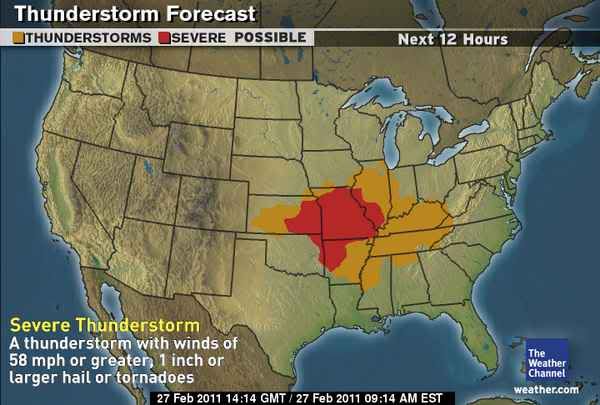
[ Bericht 6% gewijzigd door #ANONIEM op 27-02-2011 15:29:44 ]
quote:OKLAHOMA CITY -- Sunday will be mainly windy and mild with temperatures warming into the 60s and 70s. However, a slight risk of severe thunderstorms and a high risk of wildfires will develop by late afternoon.
Regarding the severe weather risk, isolated supercell thunderstorms may develop after 3 p.m. east of line from Cherokee to Hinton to Lawton. Any storm that develops will move rapidly eastward at 50 mph and could produce large hail, damaging winds, and tornadoes. The probability increases from 30 percent in central Oklahoma to 60 percent in far eastern parts of the state.
As for the risk of wildfires, a red flag warning is in effect for areas west of an Alva to Chickasha to Duncan line between the hours of 11 a.m. and 9 p.m. Westerly winds of 20 to 30 mph with gusts to 50 mph will combine with very low humidity to produce extreme fire conditions.
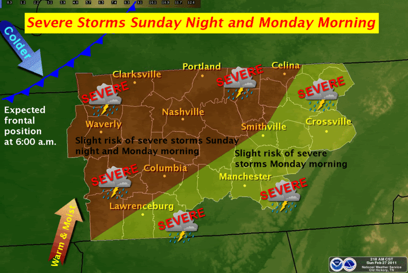
Update...
Cellen beginnen zich nu te vormen en veel chasers op pad.
http://www.news9.com/Global/category.asp?C=167025
Cellen beginnen zich nu te vormen en veel chasers op pad.
http://www.news9.com/Global/category.asp?C=167025
SPOILEROm spoilers te kunnen lezen moet je zijn ingelogd. Je moet je daarvoor eerst gratis Registreren. Ook kun je spoilers niet lezen als je een ban hebt.Prachtige live beelden! Tornado in de maak.
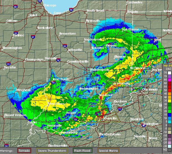
Klopt ja.. Cell is nu noord van Lexington.quote:
Nog steeds een tornado warning bij Louisville
Men geeft nog steeds een moderate risk af voor het gebied in Tennesse/Kentucky met kans op grote tornado's.
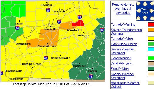

Die 2 tornado's in Oklahoma/Kansas staan dus in het filmpje een paar posts boven.. voor de rest nog "vrij" weinig ja.
Momenteel nog een groot gebied in tornado watch.
Edit:
Momenteel nog een groot gebied in tornado watch.
Edit:
SPOILEROm spoilers te kunnen lezen moet je zijn ingelogd. Je moet je daarvoor eerst gratis Registreren. Ook kun je spoilers niet lezen als je een ban hebt.Hier kan je het weer in Tennessee volgen. Momenteel alleen grote onweersbuien en nog niks ernstigs.
[ Bericht 70% gewijzigd door Drassss op 28-02-2011 15:35:23 ]
Het ging flink tekeer vannacht hier in Central Kentucky. Veel onweer en harde windstoten. De tornado warning duurde tot 9 AM, er is alleen een flood warning. Nu regent het alleen nog maar, vandaar die warning.
Oost van Cleveland weer een tornado warning, ook boven Greensboro een tornado warning.
Edit: Wateroverlast in oa Tennessee. Meer dan 4 inch regen gevallen binnen 24 uur. De staat kent nu nieuwe "rivieren"
http://www.weather.com/ou(...)-tornado-forms-19814
Filmpje tornado OK/KA
[ Bericht 35% gewijzigd door Drassss op 28-02-2011 22:27:26 ]
Edit: Wateroverlast in oa Tennessee. Meer dan 4 inch regen gevallen binnen 24 uur. De staat kent nu nieuwe "rivieren"
http://www.weather.com/ou(...)-tornado-forms-19814
Filmpje tornado OK/KA
[ Bericht 35% gewijzigd door Drassss op 28-02-2011 22:27:26 ]
quote:A confirmed tornado in Franklin County is blamed for the death of a 61 year old man who was trapped under debris. Melvin Hambrick's mobile home was destroyed when the tornado touched down on U-T Farm Road in Estill Springs. His daughter and grandson crawled out but he died at the scene. Officials say the twister uprooted trees and narrowly missed an elementary school. Early on officials were pretty certain a tornado had hit their community. The National Weather Service in Huntsville, Alabama says a preliminary investigation indicates that an EF-2 force tornado hit Franklin County.
Spring 2011 Forecast: Tornadoes, Flooding, Drought
[ Bericht 28% gewijzigd door #ANONIEM op 04-03-2011 12:30:03 ]
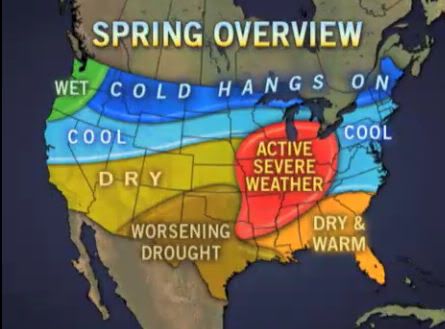
[ Bericht 28% gewijzigd door #ANONIEM op 04-03-2011 12:30:03 ]
Tornado treft Louisiana
Als gevolg van een tornado in de Amerikaanse staat Louisiana zijn zaterdag een dode en veertien gewonden gevallen. Het zwaarst werd de plaats Rayne getroffen, 100 kilometer ten westen van de hoofdstad van de deelstaat, Baton Rouge. Tientallen huizen in Rayne zijn volledig verwoest. Ongeveer 2500 mensen moesten uit de plaats worden geëvacueerd omdat gasleidingen waren gesprongen.
Het slechte weer in de regio met regens en harde wind belastte ook het carnavalsfeest in New Orleans in het zuidoosten van Louisiana. Dit feest is een van de populairste carnavalsfeesten in de Verenigde Staten. Ook de aangrenzende staat Mississippi is dit weekeinde door tornado's getroffen.
Bron De Pers
Als gevolg van een tornado in de Amerikaanse staat Louisiana zijn zaterdag een dode en veertien gewonden gevallen. Het zwaarst werd de plaats Rayne getroffen, 100 kilometer ten westen van de hoofdstad van de deelstaat, Baton Rouge. Tientallen huizen in Rayne zijn volledig verwoest. Ongeveer 2500 mensen moesten uit de plaats worden geëvacueerd omdat gasleidingen waren gesprongen.

Het slechte weer in de regio met regens en harde wind belastte ook het carnavalsfeest in New Orleans in het zuidoosten van Louisiana. Dit feest is een van de populairste carnavalsfeesten in de Verenigde Staten. Ook de aangrenzende staat Mississippi is dit weekeinde door tornado's getroffen.
Bron De Pers
Weer of geen weer, altijd actueel www.onweer-online.nl
quote:More dangerous tornado season expected
The 2011 tornado season has started quickly, with more reports of damage from storms and twisters in the past two days than there were during all of the first two months of 2010 -- a trend likely to continue well into spring.
Severe weather season, as it's often referred to by meteorologists, typically peaks during May, when meteorological conditions that lead to the development of dangerous thunderstorms are most abundant. These conditions -- including a sharp north-south temperature gradient -- have emerged early this year and, based on the expected weather pattern, will likely intensify in the coming months.
Heavy thunderstorms Sunday and Monday affected a large region from the Plains eastward to the mid-Atlantic and the Carolinas, resulting in a fatality from a suspected tornado in Franklin County, Tenn., according to WKRN-TV. Over those two days, there were 389 preliminary damage reports (wind damage, hail and tornadoes), including 12 reports of tornadoes.
The same type of event occurred just last week, when there were 32 reports of tornadoes in the Tennessee Valley and Deep South on Thursday.
Through Monday, there have been about 800 preliminary reports of damage from severe weather in 2011, more than 2.5 times greater than the number through the first two months of 2010. January and February 2010 generated 307 reports, including just one February tornado.
Thunderstorms and tornadoes develop out of a strong temperature contrast from north to south across the country, along with an ample supply of moisture from the Gulf of Mexico. Storm systems emerging from the Rockies and heading east ignite the meteorological fuel.
This is precisely the type of weather pattern that is expected to continue at least through May, which is when tornado season typically peaks.
The federal government's Climate Prediction Center forecast for March through May calls for temperatures that are likely to be warmer than average in the southern part of the country and cooler than average in the northern part of the country. Thus, the contrast will be more intense than in a typical year.
In addition, the storm track is expected to remain more active than normal because of the ongoing La Nina. This is one of the typical results of a La Nina: more storms moving out of the Pacific Northwest and northern Rockies into the Plains and eventually the eastern part of the United States than during a non-La Nina year.
That's been the case recently, and these storms have pulled moisture north from the Gulf of Mexico into the sharp temperature gradient, resulting in lines of dangerous thunderstorms. Last year, the tornado season started slowly, in part because it was cooler than average in the Deep South during the latter part of winter through the first part of spring.


Tornado Risk for Louisiana... Again
Powerful thunderstorms, some capable of spawning tornadoes, will soon fire from Texas to Oklahoma then shift eastward into hard-hit Louisiana, the Florida Panhandle, Georgia, Tennessee and perhaps as far northeast as Ohio.
A multifaceted storm will target the middle of the nation today into Wednesday with snow and flooding rain in addition to the severe thunderstorms.
High winds, not associated with thunderstorms, were already causing damage and kicking up dust in California and neighboring states. This is a sign of a very dynamic system, much more so than the system that hit the south central states this past weekend.
The setup later today into Wednesday will bring the threat of multiple tornadoes. A few of the tornadoes could even be strong.
Along with the threat of tornadoes is the likelihood of multiple incidents of large hail, damaging wind gusts, lightning strikes and flash flooding.
Today/Tonight
The area of concern for today into tonight lies from Dallas and Oklahoma City eastward to Springfield, Mo., Memphis, Tenn., and New Orleans.
Severe Weather Expert and WeatherData.com CEO Mike Smith is concerned that many of the storms will occur after dark Today.
"Some of the forecast tornadoes may be especially dangerous because people will not realize the storms are there until they are at the doorstep," Smith said.
The waves of storms will progress to the east, crossing the Mississippi River and igniting to the south toward the Gulf Coast.
South and west of the main center of the large storm system, strong winds will roar in the clear air over parts of New Mexico and western Texas. The winds will be strong enough to kick up dust, knock over high profile vehicle and down power lines. The winds could also spread wildfires.
Wednesday and Beyond
Tuesday night into Wednesday, the greatest risk of tornadoes will be in the Deep South from Louisiana to the Florida Panhandle, including much of Mississippi and Alabama. However, severe thunderstorms could occur as far north as the Ohio Valley.
Like most others, this storm system will eventually reach the Atlantic coast. For much of this area the major threat may be flash and urban flooding.
At least a few of the storms along the Atlantic Seaboard late in the week could be heavy and gusty. However, it is certainly possible that severe weather rolls along part of the I-95 corridor from Florida to Maine.
Meteorology of the Outbreak
A surge of warm, moist air will roll northward over the lower Mississippi Valley and into the southern Plains today. At the same time a sweep of dry air will attack from the west.
The combination of these two clashing air masses along with a developing surface storm and jet stream energy from above will allow severe thunderstorm to develop.
The shifting of winds with height will cause some of these thunderstorms to rotate. The rotation, in turn, can yield a tornado.
In more technical terms, the storm system will take on what meteorologists call a "negative tilt."
Intensifying systems of this nature have a long history of producing multiple tornadoes because of the way they are stacked through various layers of the atmosphere.
They are indicative of a cold air invasion high in the atmosphere, which allows the rising column of air within the thunderstorms to always be warmer than its surrounding environment.
[ Bericht 3% gewijzigd door #ANONIEM op 08-03-2011 17:00:38 ]
Powerful thunderstorms, some capable of spawning tornadoes, will soon fire from Texas to Oklahoma then shift eastward into hard-hit Louisiana, the Florida Panhandle, Georgia, Tennessee and perhaps as far northeast as Ohio.
A multifaceted storm will target the middle of the nation today into Wednesday with snow and flooding rain in addition to the severe thunderstorms.
High winds, not associated with thunderstorms, were already causing damage and kicking up dust in California and neighboring states. This is a sign of a very dynamic system, much more so than the system that hit the south central states this past weekend.
The setup later today into Wednesday will bring the threat of multiple tornadoes. A few of the tornadoes could even be strong.

Along with the threat of tornadoes is the likelihood of multiple incidents of large hail, damaging wind gusts, lightning strikes and flash flooding.
Today/Tonight
The area of concern for today into tonight lies from Dallas and Oklahoma City eastward to Springfield, Mo., Memphis, Tenn., and New Orleans.
Severe Weather Expert and WeatherData.com CEO Mike Smith is concerned that many of the storms will occur after dark Today.
"Some of the forecast tornadoes may be especially dangerous because people will not realize the storms are there until they are at the doorstep," Smith said.

The waves of storms will progress to the east, crossing the Mississippi River and igniting to the south toward the Gulf Coast.
South and west of the main center of the large storm system, strong winds will roar in the clear air over parts of New Mexico and western Texas. The winds will be strong enough to kick up dust, knock over high profile vehicle and down power lines. The winds could also spread wildfires.
Wednesday and Beyond
Tuesday night into Wednesday, the greatest risk of tornadoes will be in the Deep South from Louisiana to the Florida Panhandle, including much of Mississippi and Alabama. However, severe thunderstorms could occur as far north as the Ohio Valley.
Like most others, this storm system will eventually reach the Atlantic coast. For much of this area the major threat may be flash and urban flooding.
At least a few of the storms along the Atlantic Seaboard late in the week could be heavy and gusty. However, it is certainly possible that severe weather rolls along part of the I-95 corridor from Florida to Maine.
Meteorology of the Outbreak
A surge of warm, moist air will roll northward over the lower Mississippi Valley and into the southern Plains today. At the same time a sweep of dry air will attack from the west.
The combination of these two clashing air masses along with a developing surface storm and jet stream energy from above will allow severe thunderstorm to develop.
The shifting of winds with height will cause some of these thunderstorms to rotate. The rotation, in turn, can yield a tornado.
In more technical terms, the storm system will take on what meteorologists call a "negative tilt."
Intensifying systems of this nature have a long history of producing multiple tornadoes because of the way they are stacked through various layers of the atmosphere.
They are indicative of a cold air invasion high in the atmosphere, which allows the rising column of air within the thunderstorms to always be warmer than its surrounding environment.
[ Bericht 3% gewijzigd door #ANONIEM op 08-03-2011 17:00:38 ]
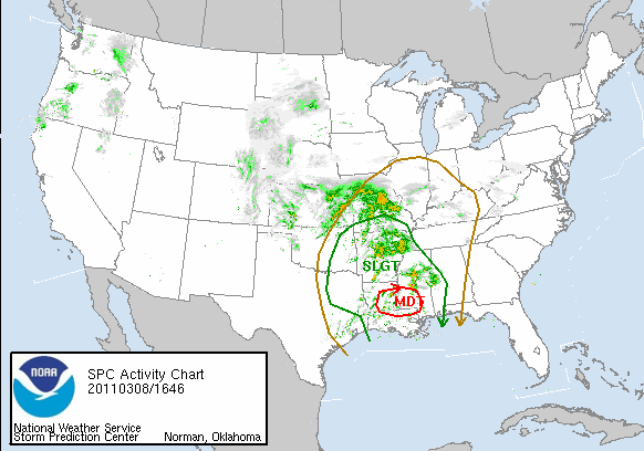
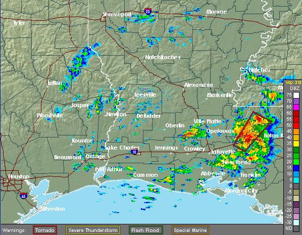
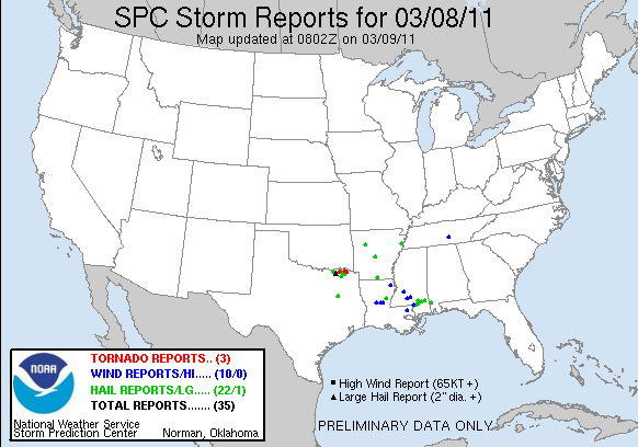
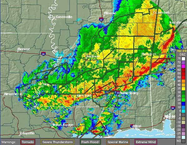
SPOILEROm spoilers te kunnen lezen moet je zijn ingelogd. Je moet je daarvoor eerst gratis Registreren. Ook kun je spoilers niet lezen als je een ban hebt.Wanneer je het wil volgen, klik op bovenstaand linkje.
Veel wateroverlast momenteel in de regio New Orleans
Stad Pensacola onder een tornado-warning momenteel
Hier is alles weer te volgen:
http://www.fox10tv.com/generic/video/LiveStream_FOX10
Hier is alles weer te volgen:
http://www.fox10tv.com/generic/video/LiveStream_FOX10
Meerdere tornado waarschuwingen, idd in de buurt van Pensacola
[ Bericht 1% gewijzigd door #ANONIEM op 09-03-2011 19:17:54 ]
[ Bericht 1% gewijzigd door #ANONIEM op 09-03-2011 19:17:54 ]
Weet niet of je mee kijkt Aloa, maar er is toch in de buurt van Mobile een krachtige tornado voorbij gekomen.. veel schade daar aan winkels/gebouwen/hoog spanningen etc etc
Edit: Stadje, Silverhill in Alabama getroffen door een tornado
[ Bericht 17% gewijzigd door Drassss op 09-03-2011 23:27:28 ]
Edit: Stadje, Silverhill in Alabama getroffen door een tornado

[ Bericht 17% gewijzigd door Drassss op 09-03-2011 23:27:28 ]
Er gebeurt veel momenteel zo te zien... tornadovideos.net zal ook wel live broadcasten.
's Avonds een man, overdags rustig an

Severe Outbreak Next Week May Affect a Quarter of US
After Florida was ransacked two days in a row with tornadoes, wind damage and battering hail, another outbreak of severe thunderstorms, including the risk of tornadoes, is set to unfold across a much larger area of the country early next week.
"This severe weather outbreak may affect a quarter of the U.S.," AccuWeather.com Senior Meteorologist Mike Smith stated.
It's a storm set to unload more snow across areas from the Rockies into the Upper Midwest this weekend into early next week that will also spark the widespread severe weather to its south.
"This is a very serious weather situation we have coming up and we have been issuing pinpoint severe weather warnings the past several days," said Bradley J. Mitchell, Chief Commercial Officer of AccuWeather Enterprise Solutions, "Notifying our SkyGuard clients of how this severe weather could affect their most important assets is a top priority for us."
While a few thunderstorms affecting areas from Missouri into Iowa and parts of the lower Midwest Saturday night into Sunday could become severe (mainly due to hail), the main outbreak of severe weather will not get under way until Sunday night and Monday.
On Sunday night, nasty thunderstorms will strike an area from northeastern Texas to northern Illinois and Indiana. Chicago and St. Louis are both included in the zone at risk for damaging thunderstorms.
The greatest threat for tornadoes will lie from northwestern Illinois to eastern Iowa and Missouri.
Threats with this outbreak Monday and Tuesday will include high winds, capable of downing trees and power lines and causing structural damage, large hail, and torrential rainfall, and even tornadoes with the strongest of thunderstorms.
Travel disruptions, by ground and air, are likely. Power outages will also be a problem for communities that are hit.
Areas from the Ohio, Tennessee, and Lower Mississippi valleys will be at risk by Monday as an extensive line of severe thunderstorms develops. Cities and towns from East Texas to western Pennsylvania are included.
The threat will then expand farther east across the Southeast and mid-Atlantic Monday night into Tuesday.
Metropolitan areas that could be affected Monday include Pittsburgh, Pa., Columbus, Ohio, Indianapolis and Evansville, Ind., Memphis, Tenn., Shreveport, La., and Houston, Texas.
Areas that will have to be monitored for possible impacts Monday night into Tuesday include Atlanta, Ga., Raleigh and Charlotte, N.C., Charleston, S.C. The thunderstorms could end up being disruptive to Tuesday's practice round for the Masters Golf Tournament in Augusta, Ga., if the line of thunderstorms progresses slower than expected.
It is still uncertain how far south the severe weather will extend into Florida Tuesday. Areas such as Tampa and Orlando that were in the heart of severe weather last Wednesday into Thursday will be closely monitored for potential impacts.
Op dit moment 10 thunderstorm warnings en 1 tornado warning. Ziet er spectaculair uit allemaal. Maar echt mooi georganiseerde / losstaande cellen heb ik nog niet gezien.
Weinig kans op tornado's vandaag 5% ongeveer.. Het weer is er net niet voor en zoals Them2 al aangeeft, weinig cellen maar meer 1 groot front.
Eerste extreem onweer
In ons eigen land is het momenteel rustig lenteweer met veel zon en middagtemperaturen die iets boven normaal liggen voor de tijd van het jaar. Rustig is het bepaald niet aan de andere kant van de Atlantische Oceaan. In het zuidoosten en oosten van de Verenigde Staten was het afgelopen week zeer onstuimig. De eerste hevige onweersbuien raasden over diverse staten van het zuidelijk gelegen Louisiana tot in het noordoostelijk gelegen Maryland en vrijwel alle staten ten zuidoosten van die lijn. Ongeveer 1300 zogeheten ‘trained spotters’ namen binnen 24 uur windschade, verschillende tornado’s en waterhozen of hevig onweer waar. De eerste onweerssituatie van het seizoen gaat dan ook meteen de recordboeken in, niet per se voor de grote hoeveelheid blikseminslagen of de verschillende tornado’s, maar vooral voor de extreme windsnelheden die soms opliepen tot 136 kilometer per uur.
Vanuit het warme Caribische gebied werd die dag vrij warme lucht in de zuidoosthoek van de Verenigde Staten aangevoerd, maar tegelijkertijd trok vanuit het noorden een koufront deze regio binnen. De zeer warme Caribische lucht en de nog winterkoude lucht vanuit onder andere Canada botsten langs een bijna 1500 kilometer lange lijn van de staat Louisiana tot aan Maryland op elkaar, die daarna verder activerend naar het zuidoosten richting de oostkust trok. Koude lucht is zwaarder en de warme Caribische lucht schoof dan ook met hoge snelheid omhoog over de koude lucht heen. Snel stijgende, warme en bovendien vochtige lucht zijn de 3 ultieme ingrediënten voor hevige buien of in dit geval een buienlijn.
Die lijn resulteerde op veel plaatsen in die hoek van Amerika in extreem weer. Er zijn in de zeer korte tijd dat de lijn overtrok 626 extreem weer waarschuwingen uitgegeven. Het onweerde bijna aan één stuk door en ongeveer 340.000 keer bereikten bliksemflitsen de aarde tijdens de buien. Ook werden hagelstenen van bijna 8 centimeter in diameter waargenomen en kwam het rond 26 keer tot tornado’s en nog diverse keren tot zogeheten tuba’s (een funnel cloud, ofwel een tornado die de grond niet raakt) en waterhozen.
Trained spotters
Bij Meteo Consult maken we voor onze verwachting dagelijks gebruik van meetgegevens en data van een groep vaste waarnemers. Deze hebben vaak een weerstation in de tuin of op het dak staan en mailen deze gegevens aan ons door. Ook bij extreem weer laten zij vaak van zich horen en dagelijks komen bovendien honderden foto’s binnen van weerliefhebbers en waarnemers. Deze waarnemers bevinden zich op allerlei verschillende plaatsen van het land en naast de officiële modelgegevens geven hun gegevens een duidelijk beeld van de situatie op een bepaald moment. Ook gebruiken we de gegevens van het waarnemersnetwerk van Het weer actueel.
In de Verenigde Staten werken weerbureaus samen met zogeheten ‘trained weather spotters’. Dit zijn waarnemers die hun gegevens doorsturen, maar het woord ‘trained’ laat al zien dat deze waarnemers er voor opgeleid zijn. De NWS, National Weather Service’ organiseert eens in de zoveel tijd een gratis cursus over de structuren en vorming van hevige onweer- of hagelbuien, maar ook de vorming van een tornado of een orkaan komt in de cursus aan bod. In principe kan iedereen naar deze cursussen, maar vaak zijn het mensen die op wat voor een manier dan ook al met het weer bezig zijn voor hun werk, zoals brandweermannen of mensen die in de wegenbouw zitten. Zij leren in deze cursussen om de horizon te scannen naar omstandigheden en voorwaarden die zouden kunnen leiden tot trechterwolken (tuba), arcus (shelfcloud), een tornado, etc. Na zo’n training krijgen zij een identificatienummer en deze gebruiken zij in het waarnemingsnetwerk van ruim 280.000 personen in de hele USA.
Recordhoogte
Tijdens de hevige buien van afgelopen 4 april kwamen ruim 1300 rapporten vanuit allerlei hoeken in het zuidoosten en oosten van de Verenigde Staten binnen. Alleen al voor extreem weer kwamen 626 meldingen binnen. Hiermee komt deze dag uit op de derde plek in de recordboeken in de lijst van meest actieve ‘zwaar weer dagen’. Op de eerste plaats staat het extreme weer op 7 april 2006, toen kwamen meer dan 700 meldingen binnen.
bron
Lol dat spektakel ken ik, vorig jaar ook vele malen afgekondigd, maar toen kwam er ook niets. Als er 2% kans was op een tornado gebeurde t meeste daarquote:
Jaja, het wordt spektakel dit weekend in de VS!
Weer of geen weer, altijd actueel www.onweer-online.nl
Ja dat is waar. Laat ik het zo zeggen; alle ingrediënten zijn aanwezig voor heftig weer.quote:
[..]
Lol dat spektakel ken ik, vorig jaar ook vele malen afgekondigd, maar toen kwam er ook niets. Als er 2% kans was op een tornado gebeurde t meeste daar
's Avonds een man, overdags rustig an
Verwachting is toch dat er grote tornado's gaan ontstaan in de staat Wisconsin, met extreme hagel/wind.
Upper Midwest Faces Worst of Today's Tornado Outbreak
The atmosphere is ripe for an outbreak of destructive tornadoes and violent thunderstorms to ignite across the Heartland of the U.S. this afternoon and tonight, with the greatest threat centered over the Upper Midwest.
"There is potential for loss of life and widespread destruction is some communities," AccuWeather.com Expert Senior Meteorologist Alex Sosnowski warned about the impending outbreak.
The severe weather event will get under way this afternoon as intense thunderstorms erupt from southeastern Minnesota and western Wisconsin to northeastern Texas.
The violent thunderstorms will then shift to lower Michigan, the lower Ohio Valley and central Texas as tonight progresses.
The threat for destructive tornadoes will be highest this afternoon and evening before the violent thunderstorms form into a more organized squall line.
While an isolated tornado cannot be ruled out as far south as Texas, the Upper Midwest is where the atmosphere will fuel the development of multiple strong and long-tracking tornadoes.
More specifically, the greatest threat to lives and property from the tornadoes will encompass southeastern Minnesota, a large portion of Wisconsin, eastern Iowa and northwestern Illinois.
Cities at risk include Minneapolis, Minn., Rochester, Minn., Eau Claire, Wis., Madison, Wis., Cedar Rapids, Iowa, and Rockford, Ill. This zone lies just south of Duluth, Minn.
The tornadoes could leave a trail of damage similar or worse than what was reported across western Iowa Saturday evening.
Fortunately, no lives were lost due to Saturday's tornadoes. Residents across the nation's Heartland should heed tornado safety tips and tornado warnings to assure the same can be said for later today.
However, Sosnowski cautioned that "you don't have to be hit by a tornado to have major damage or to be at risk for injury."
In addition to spawning tornadoes, any of the strongest thunderstorms from the Upper Midwest to Texas will be capable of unleashing damaging winds, golf ball- to baseball-sized hail, flash flooding and frequent lightning.
All of the severe weather-related injuries on Saturday were the result of either damaging winds or a lightning strike, not tornadoes.
Strong winds within violent thunderstorms can do more than litter yards and roads with trees and power lines. Semi-trucks and campers can get overturned. Falling trees could cause bodily harm or death, even to those in cars.
The threat for the severe thunderstorms will not end with the weekend. On Monday, the danger zone will shift to the Ohio Valley and Deep South.


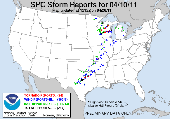
Gister 7 tornado reports.. vandaag verwacht men weer een outbreak. De lijn is verschoven naar het oosten en onder andere Mississippi & Tennessee gaan er flink van langs krijgen.

Mooie cel!quote:Op zondag 10 april 2011 21:54 schreef meteo-online het volgende:
Gisteren....
[ afbeelding ]
[ afbeelding ]
[ afbeelding ]
[ afbeelding ]


Jep en kans op krachtige tornado's/ flinke hagel en wind.. Het daar pas laat in de middag/avond gaan gebeuren dus dat is voor ons rond middernacht.quote:
15% kans op tornado's, dat is best veel.
http://www.news9.com/cate(...)er-2?redirected=true
Voor mensen die het willen volgen. Nieuws zender in Oklahoma met verschillende chasers + heli
[ Bericht 16% gewijzigd door Drassss op 14-04-2011 23:07:26 ]
Voor mensen die het willen volgen. Nieuws zender in Oklahoma met verschillende chasers + heli
[ Bericht 16% gewijzigd door Drassss op 14-04-2011 23:07:26 ]
Mooie beelden, bedankt Drassss! Die cel bij Tulsa en in het zuiden van OK zien er goed uit.
's Avonds een man, overdags rustig an
Geen probleem.quote:
Mooie beelden, bedankt Drassss! Die cel bij Tulsa en in het zuiden van OK zien er goed uit.
Ja die cel is briljant.. helaas gaat hij door bevolkt gebied dus dat is minder relax..
Ja dat is/wordt gevaarlijk. Veel cellen hebben ook een mooie haak, dus dat belooft wat.
's Avonds een man, overdags rustig an
Michael Ratliff volgen: http://chase.tornadovideos.net/pages/full_screen
's Avonds een man, overdags rustig an
Toch nog 1 dode..quote:OKLAHOMA CITY -- Severe storms that extended east of I-35 from Ardmore to Ponca City caused large hail, multiple tornadoes and one fatality Thursday.
One person was killed and four people were critically injured in Tushka in Atoka County. The sheriff reported the school was heavily damaged and part of the roof was blown off at Walmart. Many homes and businesses in the town five miles south of Atoka were damaged when a large tornado moved through the area.
Track storms using News 9's Interactive ESP Radar
Severe Weather
At 4:15 p.m. storm spotters confirmed a very dangerous tornado moving near Shidler, northeast at 30 mph. Shidler is located about 30 miles east of Ponca City.
Another tornado was spotted in southeastern Oklahoma near Davis.
A third tornado was spotted northeast of Stroud at about 4:42 p.m. People in the area said the funnel appeared for only a minute or so, but blew out some windows in the area.
A tornado touched down near Welty at about 6:15 p.m. Welty is 15 miles south of Bristow.
A tornado was reported just north of Madill at 6:10 p.m. overturning three tractor trailers and damaging power lines. The Oklahoma Highway Patrol said it may have hit a trailer park, but no injuries were reported. Marshall County Emergency Management Director Hubert Weaver said three structures had roof damage from the storm that hit east of town near Highway 99.
Storm trackers also spotted a tornado near Milburn at about 7 p.m.
Osage County deputy emergency management director Adrian Horn said a twister touched down near Hominy Thursday, damaging at least one home and a business, and knocking down telephone poles, power lines and trees. There were no reports of injuries.
Horn also said officials were trying to confirm whether a tornado touched down near Burbank.
Pontotoc County Emergency Management reported downed power lines and tree limbs in the Allen and Stonewall areas. Additional damage was reported south of Stonewall toward Fittstown where one trailer had its roof blown off and three homes lost roofs. A tree also fell on a car. Softball size hail was reported west of Hickory.
Because of the severity of the storms, it is important to make sure you and your family have a severe weather plan, and know where you're going to take shelter if necessary.
Nog steeds waarschuwingen voor tornado's
[ Bericht 58% gewijzigd door #ANONIEM op 15-04-2011 13:53:16 ]
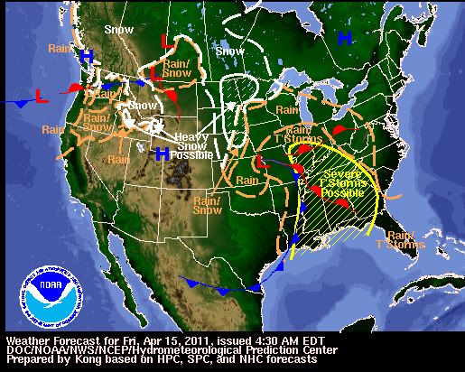
[ Bericht 58% gewijzigd door #ANONIEM op 15-04-2011 13:53:16 ]
Strong Storm, Tornado Threat Shifts to the Southeast
Following deadly tornadoes and strong thunderstorms across the nation's midsection late Thursday, the threat for powerful storms will shift to the Southeast today.
A line of damaging thunderstorms will plow through the lower Mississippi Valley first today, impacting cities such as Alexandria, La., Vicksburg, Miss., and Jackson, Tenn., this morning.
By this afternoon and evening, more storms are expected to blossom farther east, making for a potentially active severe weather day across the Mississippi Delta region, the Florida Panhandle, much of Alabama and Mississippi and areas north to the Ohio Valley.
The primary threat from most of the storms will be powerful wind gusts, perhaps greater than 70 mph, as well as large hail that could shatter car windshields and damage homes.
The threat for tornadoes is also particularly high today. Whether at work, home or on the road, stay alert for any possible tornado warnings and seek a safe shelter right away if warned.
Safe shelters for those indoors include basements, interior closets and hallways. Mobile homes and vehicles should be abandoned for a secure building right away.
Cities that are under the threat for severe storms today include Evansville, Ind., Louisville and Bowling Green, Ky., Nashville, Tenn., Huntsville, Birmingham and Montgomery, Ala., Jackson, Miss., Baton Rouge and New Orleans, La., and Pensacola, Fla.
Numerous interstates will be impacted, including I-10, I-24, I-40, I-55, I-59, I-65 and I-85.
Given the powerful nature of the parent storm system, the threat for severe thunderstorms and isolated tornadoes will persist well after dark as storms march east into western Florida, Georgia and the southern Appalachians.
Asheville, N.C., Atlanta, Ga., and Tallahassee, Fla., are among the locations that could see a dangerous thunderstorm by nightfall.
On Saturday, severe storms could approach the Atlantic coastline, threatening communities from the Delmarva Peninsula south to the coast of eastern Florida.

Following deadly tornadoes and strong thunderstorms across the nation's midsection late Thursday, the threat for powerful storms will shift to the Southeast today.
A line of damaging thunderstorms will plow through the lower Mississippi Valley first today, impacting cities such as Alexandria, La., Vicksburg, Miss., and Jackson, Tenn., this morning.
By this afternoon and evening, more storms are expected to blossom farther east, making for a potentially active severe weather day across the Mississippi Delta region, the Florida Panhandle, much of Alabama and Mississippi and areas north to the Ohio Valley.
The primary threat from most of the storms will be powerful wind gusts, perhaps greater than 70 mph, as well as large hail that could shatter car windshields and damage homes.
The threat for tornadoes is also particularly high today. Whether at work, home or on the road, stay alert for any possible tornado warnings and seek a safe shelter right away if warned.
Safe shelters for those indoors include basements, interior closets and hallways. Mobile homes and vehicles should be abandoned for a secure building right away.
Cities that are under the threat for severe storms today include Evansville, Ind., Louisville and Bowling Green, Ky., Nashville, Tenn., Huntsville, Birmingham and Montgomery, Ala., Jackson, Miss., Baton Rouge and New Orleans, La., and Pensacola, Fla.

Numerous interstates will be impacted, including I-10, I-24, I-40, I-55, I-59, I-65 and I-85.
Given the powerful nature of the parent storm system, the threat for severe thunderstorms and isolated tornadoes will persist well after dark as storms march east into western Florida, Georgia and the southern Appalachians.
Asheville, N.C., Atlanta, Ga., and Tallahassee, Fla., are among the locations that could see a dangerous thunderstorm by nightfall.
On Saturday, severe storms could approach the Atlantic coastline, threatening communities from the Delmarva Peninsula south to the coast of eastern Florida.
| Forum Opties | |
|---|---|
| Forumhop: | |
| Hop naar: | |