WKN Weer, Klimaat en Natuurrampen
Lees alles over het onstuimige weer op onze planeet, volg orkanen en tornado's, zie hoe vulkanen uitbarsten en hoe Moeder Aarde beeft bij een aardbeving. Alles over de verwoestende kracht van onze planeet en tal van andere natuurverschijnselen.


Alles is gunstig voor ontwikkeling maar het gebeurd (nog) nietquote:There has been an increase in convection or thunderstorm activity with 92L over night. Deep tropical thunderstorms are what drive the heat engine of tropical cyclones. Without convection and upward motion in the atmosphere, the chain reaction cycle cannot be sustained. It will be important now to see if the convection persists or if it comes in bursts. Persistent convection will indicate a steadily strengthening system while bursting indicates one that is struggling.
All of the factors that lead to additional development seem to be in place and thus the NHC is indicating a 60% chance that this will go on to become at least a tropical depression over the next 48 hours. In fact, sea surface temps along the path of 92L are running about two degrees F above normal and are only getting warmer. Upper level winds are favorable in the region as a large area of upper level high pressure builds out over the eastern Atlantic. This acts to shield tropical systems from strong winds high in the atmosphere, giving them room to grow and strengthen. What is odd, however, is the lack of development shown in computer models such as the GFS, ECMWF or UKMET. These are typically reliable models for picking up on the birth of tropical cyclones (tropical cyclogenesis) but are notably reluctant to develop 92L very much. I am very interested to see what happens- whether or not these models are that good and nothing much happens with this system or if it in fact goes on to become a tropical storm, how the models missed it. As I said, there are no obvious reasons for this not to develop but it is extremely early in the season for us to be talking about central Atlantic, deep tropical development

Kans dat het nog wat wordt is gedaald naar 40 %
quote:SHOWERS AND THUNDERSTORMS ASSOCIATED WITH AN AREA OF LOW PRESSURE
LOCATED ABOUT 1375 MILES EAST OF THE WINDWARD ISLANDS HAVE BECOME
LESS ORGANIZED TODAY. ENVIRONMENTAL CONDITIONS ARE MARGINALLY
CONDUCIVE FOR DEVELOPMENT...BUT ARE EXPECTED TO BECOME LESS
FAVORABLE IN A DAY OR TWO. THERE IS A MEDIUM CHANCE...40
PERCENT...OF THIS SYSTEM BECOMING A TROPICAL CYCLONE DURING THE 48
HOURS AS IT MOVES WEST-NORTHWESTWARD TO NORTHWESTWARD AT ABOUT 15
MPH.
Dat onweerscomplex daarachter lijkt er ook wel veelbelovend uit te zien:

's Avonds een man, overdags rustig an
Deze lost denk ik helemaal op dus wachten op de volgendequote:Op maandag 14 juni 2010 22:38 schreef Burnie88 het volgende:
Dat onweerscomplex daarachter lijkt er ook wel veelbelovend uit te zien:
[ afbeelding ]
quote:GLOBAL MODELS CORRECT THIS TIME AROUND
There was apparently a reason why the global models did not show 92L developing in to anything significant. The reason being that, in fact, it looks like the system will not develop much over the coming days. As impressive as it appeared on satellite imagery, it's just too early in the season to look for east Atlantic tropical cyclone formation. Upper level winds are still just too strong and other subtle environmental conditions are not in place. However, the tropical wave has an obvious well defined low pressure center associated with it and the entire mass of energy will move off to the west to west-northwest over the next several days. We'll have to wait and see if more conducive conditions await farther west, perhaps in the western Caribbean Sea. The very fact that this system looked (and still does to some extent) so well organized for this time of year is important because it signifies a change in the deep tropics over last season. Instead of dry, stable, sinking air, which was the rule for most of last year, we are seeing a much more favorable pattern of lower pressures, higher sea surface temps and overall upward motion in the atmosphere. Once we get closer to August, I believe things will become very active and remain so through the rest of the season. 92L is a warning shot for us to take notice that the season could be very serious. For now, we are doing okay in that no significant development is expected with this feature, or elsewhere, for the next few days at least.


LOL  Bizar plaatje idd
quote:DEVELOPMENT POTENTIAL ON THE INCREASE THIS WEEK
It looks as though the quiet start to the season could come to an end soon. The ECMWF model, one of the more reliable global computer models, has been indicating the possibility of tropical cyclone formation in the Caribbean Sea for the past few days. Other models are also suggesting this but none seem to be as bullish as the ECMWF. The trigger would appear to be a tropical wave moving through the eastern Caribbean Sea now which has been labeled by the NHC as having a low chance of development over the next 48 hours. Beyond that time, perhaps four days from now, it should reach the western Caribbean and show signs of organization as an upper level high pressure area builds in across the region. This would provide the shelter needed from relentless strong winds aloft and allow for development. I am going to outline all of this on today's Weekly Hurricane Outlook video which will be broadcast live at 11am ET right here on the homepage. I will go over several of the models, including the ECMWF, to show what they are suggesting will happen. The bottom line is that it appears the pattern is going to change and allow for the potential for the first named storm of the season to develop over the coming week.

quote:A LARGE AREA OF SHOWERS AND THUNDERSTORMS OVER THE EASTERN CARIBBEAN
SEA IS ASSOCIATED WITH A STRONG TROPICAL WAVE THAT IS MOVING
WESTWARD AT 10 TO 15 MPH. ALTHOUGH THERE IS NO EVIDENCE OF A
SURFACE CIRCULATION...THIS SYSTEM IS SHOWING SOME SIGNS OF
ORGANIZATION AND ENVIRONMENTAL CONDITIONS APPEAR CONDUCIVE FOR
GRADUAL DEVELOPMENT DURING THE NEXT COUPLE OF DAYS. THIS WAVE
COULD PRODUCE LOCALLY HEAVY RAINFALL AND GUSTY WINDS OVER PORTIONS
OF NORTHERN VENEZUELA...THE NETHERLANDS ANTILLES...PUERTO
RICO...THE DOMINICAN REPUBLIC...AND HAITI OVER THE NEXT DAY OR SO.
THERE IS A MEDIUM CHANCE...30 PERCENT...OF THIS SYSTEM BECOMING A
TROPICAL CYCLONE DURING THE NEXT 48 HOURS.
Even More Hurricanes Expected this Season, Three Could Hit Oil Spill
[ Bericht 1% gewijzigd door #ANONIEM op 21-06-2010 22:59:23 ]
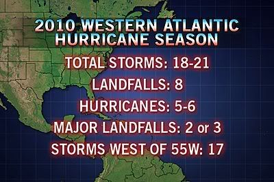
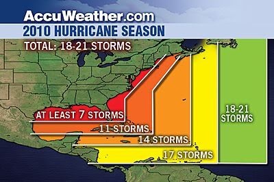
quote:The 2010 hurricane season is set to become even more extreme, with 18-21 named storms now in the forecast, and some of those storms will impact the oil spill in the Gulf.
AccuWeather.com Chief Hurricane Meteorologist Joe Bastardi has upped his original forecast from 16-18 storms, to 18-21, with at least eight impacts and six hurricanes, and two or three of those hurricanes will have major landfalls. Only five years in the 160 years of records had 18 or more storms in a season.
"The hurricane season should have several hits on the U.S. coast from July through September, mainly in the Southeast and Gulf," said Bastardi.
Bastardi suggests that based on years with a similarly active hurricane forecast as 2010, at least two hurricanes and one tropical storm are set to move through the area of the Gulf oil spill by the end of the tropical season.
As many as three other tropical systems have the potential to track close enough to the spill to impact cleanup and capping operations, as well as other oil rig operations in the Gulf.
"Above-normal tropical activity should feature four named storms in July, with one or two impacting the coastal areas," said Bastardi.
August will also feature an influx of storms.
"August should have six named storms, with two of three impacts on the U.S. coastline," said Bastardi.
Bastardi predicts the heart of this season's storms will occur between Aug. 15 and Oct. 15.
"Not only will that period be more active than normal, but the run up to it, and the time after it," said Bastardi. "There could be a period where there is a group of naming, two or three going on at once and five in a 15-20 day period."
He is confident that tropical activity will occur before mid-August in the Gulf of Mexico, the estimated time frame at which BP expects the oil leak to be capped.
Back in February, Bastardi based his predictions for the 2010 season on the tropical activity of analog years 1995, 1998, 2005 and 2008.
Most of the past analog years Bastardi considered in his 2010 forecast for the Gulf had tropical activity before the middle of August.
Even later into the summer, hurricane season will continue to ramp up.
"By late August and September, the hurricane season should be front and center," said Bastardi. "Expect eight named storms in September and three or four U.S. impacts."
An extreme winter and now an above-normal hurricane season could place 2010 in the record books.
"It's hard to fathom another 12-month period where such wild swings would make weather so significant for such a large area of the population," said Bastardi.
Hurricane season begins June 1 and ends Nov. 30.

[ Bericht 1% gewijzigd door #ANONIEM op 21-06-2010 22:59:23 ]
Die depressie bij Venezuela en de Bovenwindse eilanden gaat inderdaad Alex worden, hij krijgt zelfs al enigszins de vorm van een hurricane. Er hangt ook nog een sliert bewolking achter dat volgens mij nummer 2 gaat worden. En ik zag dat voor van de Kaapverdische eilanden zich ook e.e.a. ontwikkeld. Kijken wat dat gaat doen. Morgen verlaat ik het Caribische gebied gelukkig weer 
Net nieuwe update gezien, nu 50% kans op tropische storm. En aan de Pacific kant gaat het ook lekker, Celia naar categorie 2 en het systeem erachter 60% kans op ontwikkeling.
quote:9:30PM EDT Update 21 June 2010
The first signs of a low level circulation are beginning to appear, upping chances for development to about 50%. The circulation is roughly around 14.0N 72.0W. Assuming it maintains itself, it may be upgraded to a depression tomorrow, or more likely after recon gets out there on Wednesday.
Models are still a bit too soon to believe, the latest GFDL run appears too far to the north.

quote:6PM EDT Update 21 June 2010
The wave in the Eastern Caribbean Sea (93L) is a rather large system, but currently lacks a low level circulation. Conditions around it support a low chance for tropical development, but if it can hold together the largest chances will be when it reaches the western Caribbean sea later in the week.
Earlier forecast model runs overdid the system. This system has a better chance to develop than last week's 92L, but still the overall odds are against development. The most likely scenario is that it remains a wave or a tropical depression and moves its way into the Yucatan. While the system does not have a low level circulation, models won't be of much use.
Watching the model trends over the week, and signs for more circulation is important. There is a recon flight scheduled out for Wednesday, which is probably the best opportunity for real data and I don't expect it to be upgraded (if it is at all) before that.
Again the June factor along with the Jet are probably the biggest factors against development right now. If it has a circulation when it enters the west Caribbean, then chances go up quite a bit and could actually form into something.
In short watch it closely, but ihe wave known as 93L is most likely to impact Mexico with rain.