WKN Weer, Klimaat en Natuurrampen
Lees alles over het onstuimige weer op onze planeet, volg orkanen en tornado's, zie hoe vulkanen uitbarsten en hoe Moeder Aarde beeft bij een aardbeving. Alles over de verwoestende kracht van onze planeet en tal van andere natuurverschijnselen.


Atlantic Tropical Storm/Hurricane Formation Possible by the End of June
Judging by the overall weather pattern and ideas from several computer models, the odds are increasing for tropical cyclone formation in the western Atlantic Basin before the end of the month.
At the very least, a period of rough seas and strong thunderstorms will affect part of the Gulf of Mexico next week.
AccuWeather.com Hurricane and Long Range Expert Meteorologist Joe Bastardi assimilates the current weather pattern in the Atlantic Basin to a "tropical brew that is ready to boil over."
Water temperatures in the Gulf of Mexico, Caribbean and the Southwest Atlantic are already very warm, compared to normal.
Tropical waves of low pressure rolling westward from Africa are already very active and are progressively becoming more vigorous.
One wave, bound to cause trouble, is currently drifting slowly westward through the central Caribbean and will deliver gusty, drenching thunderstorms to Hispaniola, where Haiti is located, today.
There is an abundance of showers and thunderstorms in the Caribbean, which represents plenty of "potential energy" for tropical cyclone formation.
Some computer models are developing the tropical wave in the Caribbean later this week.
These models go so far as to spin up the first tropical storm of the Atlantic season. At least one of these models develops a hurricane over the Gulf of Mexico between the 28th and 30th.
The first name on the 2010 list in the Atlantic is "Alex."
Another tropical system is forecast by computer models to take shape shortly thereafter east of the Bahamas.
Bastardi has warned of the potential for 20 tropical cyclones in the Atlantic Basin this season. Tropical cyclones are tropical storms and hurricanes; in other words, named systems.
While the oil spill area and other coastal regions and islands will dodge some bullets, the odds of multiple tropical storms and/or hurricanes tracking over the oil spill and other locations are exceptionally high this year, due to the number of named systems expected.
Disruptions caused by multiple hurricanes to oil spill cleanup and containment operations are one matter, the potential damage and destruction to coastal areas from wind and storm surge near and well away from the oil slick, takes this season to a whole new level.
Residents, business owners and government officials need to have a plan of action for what may be an exceptional hurricane season.
While the strength of the system forecast to enter the Gulf of Mexico late this weekend into early next week is questionable, there is the risk of squalls and building seas in the vicinity of the oil slick and cleanup/containment operations for up to a several-day period.
Bron
Judging by the overall weather pattern and ideas from several computer models, the odds are increasing for tropical cyclone formation in the western Atlantic Basin before the end of the month.
At the very least, a period of rough seas and strong thunderstorms will affect part of the Gulf of Mexico next week.
AccuWeather.com Hurricane and Long Range Expert Meteorologist Joe Bastardi assimilates the current weather pattern in the Atlantic Basin to a "tropical brew that is ready to boil over."
Water temperatures in the Gulf of Mexico, Caribbean and the Southwest Atlantic are already very warm, compared to normal.
Tropical waves of low pressure rolling westward from Africa are already very active and are progressively becoming more vigorous.
One wave, bound to cause trouble, is currently drifting slowly westward through the central Caribbean and will deliver gusty, drenching thunderstorms to Hispaniola, where Haiti is located, today.

There is an abundance of showers and thunderstorms in the Caribbean, which represents plenty of "potential energy" for tropical cyclone formation.
Some computer models are developing the tropical wave in the Caribbean later this week.
These models go so far as to spin up the first tropical storm of the Atlantic season. At least one of these models develops a hurricane over the Gulf of Mexico between the 28th and 30th.
The first name on the 2010 list in the Atlantic is "Alex."
Another tropical system is forecast by computer models to take shape shortly thereafter east of the Bahamas.
Bastardi has warned of the potential for 20 tropical cyclones in the Atlantic Basin this season. Tropical cyclones are tropical storms and hurricanes; in other words, named systems.

While the oil spill area and other coastal regions and islands will dodge some bullets, the odds of multiple tropical storms and/or hurricanes tracking over the oil spill and other locations are exceptionally high this year, due to the number of named systems expected.
Disruptions caused by multiple hurricanes to oil spill cleanup and containment operations are one matter, the potential damage and destruction to coastal areas from wind and storm surge near and well away from the oil slick, takes this season to a whole new level.
Residents, business owners and government officials need to have a plan of action for what may be an exceptional hurricane season.
While the strength of the system forecast to enter the Gulf of Mexico late this weekend into early next week is questionable, there is the risk of squalls and building seas in the vicinity of the oil slick and cleanup/containment operations for up to a several-day period.
Bron
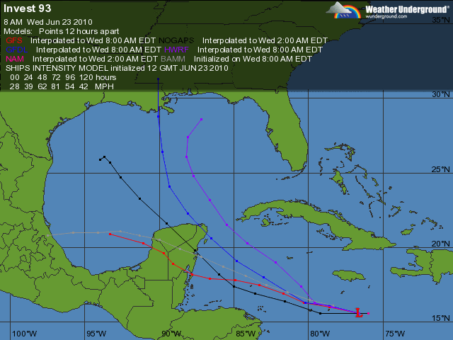
Interessant...quote:Models different: Large Hurricane in Gulf possible... or not?
I wrote yesterday that little global model support existed for the tropical wave that is lurking in the eastern Caribbean Sea. That is beginning to change. A tremendous amount of energy is gathering in the region over water that is exceptionally warm for this time of year. What I am beginning to see in the computer models is beginning to concern me.
First of all, the upper level pattern is evolving in a manner which would allow for development. A large area of light winds aloft is setting in across the western Caribbean and Gulf of Mexico over the next several days and this could allow for the system, labeled 93L, to get going. The track suggests a movement across the Caribbean Sea and possibly towards the Yucatan peninsula. From there, the global models that recognize the potential for development turn the system northward in to the Gulf of Mexico. This is certainly going to cause a stir once news begins to spread of this potential. In fact, the very latest ECMWF model, linked here suggests we really need to keep an eye on the evolution of this feature. I am not going to sugar coat the reality here- there is potential for a significant storm or even a hurricane somewhere in the Gulf of Mexico over the next week. This is not a season to pretend the hurricanes away and worry about being sensational. Water temps are well above normal, ocean heat content is already very high and to see this kind of activity originating from an African tropical wave in June is very serious.
n the short term, Haiti and surrounding land masses are in for periods of heavy, tropical rains. This is not at all what is needed down there in light of the devastating earthquake. It is going to take a while for this system to move past the area as it is not moving very fast.
In addition, another strong tropical wave well east of the Lesser Antilles is beginning to flare up. It went from being bone-dry (embedded in fairly substantial dry air known as SAL for Saharan Air Layer) to bursting with convection in a hurry. There is going to be a lot to keep up with this last week of June.

Het lijkt erop dat Darby Mexico gaat treffen.
Celia heeft een mooi oog gekregen.
[ Bericht 7% gewijzigd door #ANONIEM op 23-06-2010 19:14:08 ]
Celia heeft een mooi oog gekregen.


[ Bericht 7% gewijzigd door #ANONIEM op 23-06-2010 19:14:08 ]

Hier sturen ze hem ook steeds meer de Golf in.quote:Op woensdag 23 juni 2010 14:48 schreef Frutsel het volgende:
[ afbeelding ]
Voorlopige uitdraai voor 28e... waar ligt die daar voor de kust?New Orleans?
De kans dat de olie straks door de lucht vliegt wordt steeds groter.
[ Bericht 8% gewijzigd door #ANONIEM op 23-06-2010 19:50:03 ]
leuk met onweer erbij.. extra vuurwerk?quote:Op woensdag 23 juni 2010 19:20 schreef aloa het volgende:
[..]
Hier sturen ze hem ook steeds meer de Golf in.
De kans dat de olie straks door de lucht vliegt wordt steeds groter.
[ afbeelding ]
| Wordfeud: marcel-o |plug.dj/uptempo |<-- draai zelf je platen
quote:Op woensdag 23 juni 2010 19:20 schreef aloa het volgende:
[..]
Hier sturen ze hem ook steeds meer de Golf in.
De kans dat de olie straks door de lucht vliegt wordt steeds groter.
[ afbeelding ]
Nature stricks back!!
Laten we hopen dat de mensheid hier iets van leert.
Daar leert men niets van... helaas.quote:Op woensdag 23 juni 2010 21:44 schreef Revolution-NL het volgende:
[..]
Nature stricks back!!
Laten we hopen dat de mensheid hier iets van leert.
Ik vraag me af wat er met die olie gebeurt als er een orkaan overheen trekt. Als hier een storm van windkracht 10 overtrekt, dan zit het zout ook tot ver in het land op de ramen.
Kans gestegen naar 40%
quote:A TROPICAL WAVE LOCATED OVER THE WESTERN CARIBBEAN SEA CONTINUES TO
PRODUCE SHOWERS AND A FEW THUNDERSTORMS ACROSS PORTIONS OF
HISPANIOLA...JAMAICA...CUBA...THE CAYMAN ISLANDS...AND THE ADJACENT
WATERS OF THE NORTHERN CARIBBEAN SEA. ALTHOUGH THE LOW-LEVEL
CIRCULATION OF THE WAVE APPEARS TO BE IMPROVING...THE ASSOCIATED
SHOWER ACTIVITY STILL LACKS ORGANIZATION AND IS LOCATED MAINLY TO
THE EAST OF THE WAVE AXIS. UPPER-LEVEL WINDS APPEAR CONDUCIVE FOR
SOME SLOW DEVELOPMENT OF THIS SYSTEM AS IT MOVES WESTWARD OR
WEST-NORTHWESTWARD AROUND 10 MPH OVER THE NEXT COUPLE OF DAYS. AN
AIR FORCE RESERVE UNIT RECONNAISSANCE AIRCRAFT IS TENTATIVELY
SCHEDULED TO INVESTIGATE THE SYSTEM THIS AFTERNOON...IF NECESSARY.
THERE IS A MEDIUM CHANCE...40 PERCENT...OF THIS SYSTEM BECOMING A
TROPICAL CYCLONE DURING THE NEXT 48 HOURS. WIDESPREAD SHOWERS AND
THUNDERSTORMS ARE ALSO AFFECTING PUERTO RICO AND THE NORTHERN
LEEWARD ISLANDS BUT ARE NOT DIRECTLY ASSOCIATED WITH THE TROPICAL
WAVE.
Yupquote:Op woensdag 23 juni 2010 14:48 schreef Frutsel het volgende:
[ afbeelding ]
Voorlopige uitdraai voor 28e... waar ligt die daar voor de kust?
De olie komt dan gewoon letterlijk uit de lucht vallenquote:Op woensdag 23 juni 2010 23:07 schreef aloa het volgende:
Ik vraag me af wat er met die olie gebeurt als er een orkaan overheen trekt. Als hier een storm van windkracht 10 overtrekt, dan zit het zout ook tot ver in het land op de ramen.
En dat over een behoorlijke afstand.quote:Op donderdag 24 juni 2010 10:59 schreef Revolution-NL het volgende:
[..]
De olie komt dan gewoon letterlijk uit de lucht vallen

quote:The first signs of development could happen any time from later today through Saturday, perhaps followed by rapid strengthening early next week.
A track of a hurricane toward the central or southeastern Louisiana coast would be the worst case scenario given the current situation. Counterclockwise flow around the storm would bring significant amounts of water (and oil and tar balls) onshore as a surge. Winds in the northeastern quadrant of a hurricane moving northward are typically the strongest and would also be a concern.
Speculation will continue as to what would happen if a hurricane tracks over an oil slick the size of the spill in the northern Gulf of Mexico. However, it appears likely that we will all get an education this season, sooner or later.
http://www.accuweather.co(...)-storm-hurrica-1.asp
[ Bericht 5% gewijzigd door #ANONIEM op 24-06-2010 12:15:38 ]
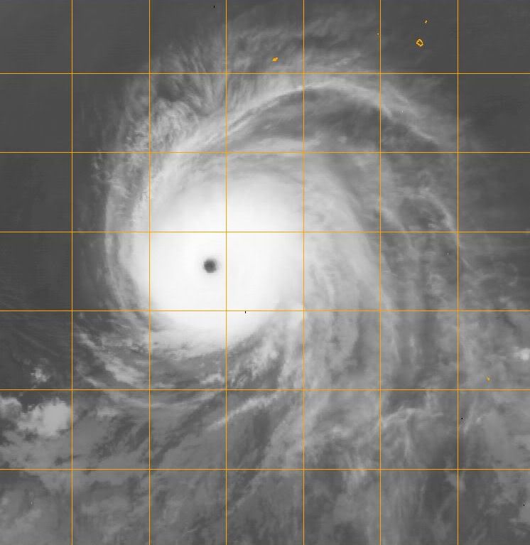
Alex komt er toch echt aan hoor.... Gestegen tot 60% en nu het warmere wateren binnenkomt ga ik er 99% vanuit dat het een orkaan gaat worden,
Aan de Pacific kant is Celia gestegen tot een categorie 5 en is Darby geupgrade naar een categorie 1.
Aan de Pacific kant is Celia gestegen tot een categorie 5 en is Darby geupgrade naar een categorie 1.
quote:Op vrijdag 25 juni 2010 04:46 schreef Vogue het volgende:
Alex komt er toch echt aan hoor.... Gestegen tot 60% en nu het warmere wateren binnenkomt ga ik er 99% vanuit dat het een orkaan gaat worden,
Aan de Pacific kant is Celia gestegen tot een categorie 5 en is Darby geupgrade naar een categorie 1.
Wanneer komt hij over de golf van Mexico is de verwachting?
quote:8 PM EDT Update 24 June 2010
The wave now entering the west Caribbean (93L) has reached far enough west to kick up the chances to 60%, if it were to develop tomorrow seems the most likely time, especially if it develops convection overnight.
It is expected to near Honduras/Nicaragua, but stay to the north and head into the Yucatan, it likely will have a chance to develop then. Once back in the gulf it may have a chance to strengthen, but it seems shear/dry air may enter into the equation the further north it gets. Those in the Yucatan and Gulf states need to monitor the wave.
7 AM EDT Update 24 June 2010
The wave in the Caribbean, with an apparent low level circulation southwest of Jamaica, is still holding on, but is taking the slow road toward development. The window for development is tonight through Saturday. The most likely scenario, still, is for it to enter the Yucatan with rain, and it may not develop before it gets there (or very late).
Models are very divergent on where it may eventually go, but the weaker condition of the storm suggests more westerly into the Yucatan. In short, in common with most undeveloped systems, they are still mostly unhelpful.
In short not much has changed with this all week, and it is still very worth watching in the Gulf and Yucatan for changes.
Currently Recon is scheduled to go out there this afternoon, it may be canceled if it doesn't look more organized close to then
Zondag op Maandag denk ikquote:Op vrijdag 25 juni 2010 08:41 schreef Revolution-NL het volgende:
[..]
Wanneer komt hij over de golf van Mexico is de verwachting?
Wat een monsterquote:
Apart dat ze hem eerst als cat.2 classificeren... dan ineens als 3... dan weer 2 en nu ineens ee vijf
Idd.. en dat nu al in juni..quote:Op vrijdag 25 juni 2010 09:22 schreef Frutsel het volgende:
[..]
Wat een monster
Apart dat ze hem eerst als cat.2 classificeren... dan ineens als 3... dan weer 2 en nu ineens ee vijf
Tis volgens mij de 2e Cat.5 orkaan in de geschiedenis van de Oostpacific, die ontstaat in Juni. Alleen orkaan Ava uit 1973 ontstond eerder dan Celiaquote:
Wow .. zeldzaam dusquote:Op vrijdag 25 juni 2010 11:21 schreef Frutsel het volgende:
[..]
Tis volgens mij de 2e Cat.5 orkaan in de geschiedenis van de Oostpacific, die ontstaat in Juni. Alleen orkaan Ava uit 1973 ontstond eerder dan Celia
Ondertussen lijkt Darby toch ook sterk te worden nu al minstens Cat.3 verwachting

Hopelijk zwakt tie genoeg af voordat hij richting land gaat.
Hij zal vast nog wel afzwakken...
Ben erg benieuwd hoe het in de Carribean zal gaan dit weekend. Ik vind de buien er niet spannend uitzien in de zin van vorming van een orkaan, maar toch 60% kans. Ben benieuwd.
Ben erg benieuwd hoe het in de Carribean zal gaan dit weekend. Ik vind de buien er niet spannend uitzien in de zin van vorming van een orkaan, maar toch 60% kans. Ben benieuwd.
's Avonds een man, overdags rustig an

Die 80% depressie zal over Yucatan gaan en dan de Golf intrekken...
's Avonds een man, overdags rustig an

Zal me niets verbazen als we binnenkort 2 namen hebben in de Atlantische Oceaan. De boel is behoorlijk aan het ontploffen.


quote:Atlantic Has Its First Tropical Depression of 2010 Season
The depression is currently located 355 miles southeast of Cozumel, Mexico and has maximum sustained winds of 35 mph.
The tropical brew of showers, thunderstorms and tropical waves in the Caribbean Sea has given birth to the first tropical depression of the 2010 Atlantic hurricane season on Friday.
Tropical Depression One is forecast by AccuWeather.com meteorologists to soon become a tropical storm, and then possibly a hurricane over the next several days. The depression is currently located 355 miles southeast of Cozumel, Mexico and has maximum sustained winds of 35 mph.
The first name on the list of Atlantic tropical cyclones this season is "Alex."
The depression destined to become Alex will drift across the Yucatan, Mexico this weekend, producing heavy rain and gusty thunderstorms. There is an elevated risk of flash flooding and mudslides over a broad area of Central America as a result of the system drifting slowly to the northwest.
A window of movement ranging from Louisiana to Tamaulipas, Mexico exists for possible storm tracks next week, as the system is expected to emerge on the northwestern side of the Yucatan Peninsula later Sunday.
Waters are very warm in the western Caribbean and in much of the Gulf of Mexico. While the system will battle with the Yucatan Peninsula this weekend, strengthening prior to and after engaging the land mass is inevitable.
The system will pull a great deal of tropical moisture northward on its eastern side. As a result, regardless of the exact track, squalls and building seas are likely not only over the central and southwestern Gulf of Mexico, but also over eastern areas.
While a track over the southwestern Gulf of Mexico would mean substantially less impact on the oil spill area, building seas and gusty thunderstorms from the tropical vale of moisture could cause some hazards and disruptions.
A track over the central and northern Gulf of Mexico would mean the roughest conditions, and prove to be the most disruptive over the oil spill area. A south to southeasterly flow on the eastern flank of such a storm track would drive the most oil toward the central Gulf Coast.
In either case, the earliest we would have landfall would be late Tuesday into Wednesday. There is some possibility of the system's forward speed slowing, which would keep nail biting going through next week.


[ Bericht 3% gewijzigd door #ANONIEM op 26-06-2010 08:31:13 ]


NEW ORLEANS - De eerste tropische storm van dit seizoen vormt zich boven de Caribische eilanden en dreigt richting de Golf van Mexico te gaan.
Het Amerikaanse Orkaancentrum (NHC) maakte zaterdag bekend dat de storm nu al windsnelheden van 55 kilometer per uur telt.
De storm zal naar verwachting in de loop van de week in kracht toenemen en dwars door het gebied razen waar duizenden liters olie op het water drijven.
Gevreesd wordt dat de werkzaamheden aan het olielek in de Golf van Mexico door de storm gehinderd zullen worden. Ook leeft de angst dat de wind nog meer olie aan land zal blazen.
Kwetsbare natuurgebieden
De kustgebieden van de staten Louisiana, Mississipi, Alabama en Florida kampen al met olie op de stranden en in de kwetsbare natuurgebieden. Ook het toerisme wordt door de olieramp flink geraakt. De kustwacht zegt geen idee te hebben wat te verwachten van het effect van de storm op de olie. ''Dit is de eerste keer en we hebben geen draaiboek'', aldus een woordvoerder.
De olielekkage die is ontstaan door het zinken van Deepwater Horizon eind april is de grootste in de geschiedenis van de VS. Tientallen miljoenen liters ruwe olie zijn in zee gestroomd. Olieproducent BP probeert met man en macht het lek te dichten, maar is daar ondanks verscheidene pogingen nog niet in geslaagd.
Als het hogedrukgebied boven de VS verdrongen wordt door het lagedrukgebied in het noorden, dan kan Alex wel eens recht over de oil spill gaan en recht afstevenen op New Orleans... Wordt echt spannend de komende dagen. Al scheelt het wel dat Alex geen cat. 2 of hoger hurricane zal worden.
's Avonds een man, overdags rustig an
quote:As Tropical Storm Alex pushes northwestward, it will unleash tremendous thunderstorms, torrential downpours, and flooding to portions of Central America and southeastern Mexico this weekend.
The large, slow-moving nature of Alex could result in great loss of life in unprotected, unsuspecting areas.
Big, slow-moving, repeating thunderstorms will fire over the water and nearby areas from Honduras, Guatemala and Belize to Mexico's Yucatan, Chiapas, Campeche, Quintana Roo and Tabasco states.
Daytime heating, combined with excess tropical moisture, will fuel the thunderstorms over land areas, while the tropical nature of the system will brew thunderstorms over nearby waters. A circulation around Alex will drive the ocean-bred thunderstorms onshore.
While the developing situation is of great concern to the Gulf of Mexico early next week, the immediate concern for these countries is that of life-threatening flash flooding and mudslides.
Renewed strengthening of Alex is expected over the southwest Gulf of Mexico early next week. Alex is forecast by AccuWeather.com to become a strong tropical storm or hurricane before a second landfall next week on a track favoring a more westward, rather than northward movement.
The size, strength and track of Alex over the southwest Gulf of Mexico next week will determine the amount of rainfall and the nature of flooding in the Vera Cruz, Nuevo Leon and Tamaulipas states in Mexico and perhaps part of the Texas coast of the U.S.
While Alex is still being pushed steadily along by stronger-than-usual easterlies, as the storm moves more to the northwest with time, the tropical easterly flow weakens and could result in decreased forward speed of the storm from mid- to late week. Hence, the continued concern for flooding.

Het ziet ernaar uit dat deze niet over de olie heen gaat, maar ik ga er van uit dat er de komende weken wel eentje daar in de buurt gaat komen...
Waarom niet dan is het meteen mooi netjes opgeruimd uit zee en ligt het op landquote:Op zaterdag 26 juni 2010 17:25 schreef kahaarin het volgende:
Hmm, ik hoop echt dat het de olierampspot gaat missen.
Maar als het zover komt dan is het een mooie reden om verder te kijken naar alternatieve energie
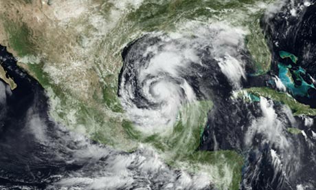
Wat een enorm systeem zeg.
Als het de golf van mexico induikt gaat het wel nog de orkaanstatus bereiken. De meeste modellen sturen hem nu richting Mexico i. p .v de amerikaanse kust.
Als het de golf van mexico induikt gaat het wel nog de orkaanstatus bereiken. De meeste modellen sturen hem nu richting Mexico i. p .v de amerikaanse kust.
quote:Olie-industrie vreest storm Alex
De olieindustrie in de Golf van Mexico maakt zich zorgen over tropische storm Alex. Oliemaatschappij Shell is bezig om personeel te evacueren van booreilanden in de buurt. Ook BP volgt storm Alex nauwkeurig.
Alex is de eerst tropische storm van het seizoen.
Vooralsnog lijkt er geen gevaar voor de schepen die aan het werk zijn rond het olielek bij het gezonken platform Deepwater Horizon, maar het Amerikaanse orkaancentrum waarschuwt dat de storm onvoorspelbaar is.
Op dit moment nadert de storm het Mexicaanse schiereiland Yucatan. Enkele honderden toeristen zijn op de vlucht geslagen voor de storm.
http://nos.nl/artikel/167785-olieindustrie-vreest-storm-alex.html


idd
Achter Alex zit nu ook dat nieuwe gebied... Maar dat lijkt weinig potentie tot ontwikkeling te hebben.
Achter Alex zit nu ook dat nieuwe gebied...
GFS blijft volhouden dat Alex ergens bij Houston Landfall gaat maken. Een ander model heeft de storm nu ook wat noordelijker staan.
Het begint er steeds meer op te lijken dat GFS gelijk gaat krijgen. Nu 3 modellen, die ook een meer noordelijker koers aangeven.

Vergelijk onderstaande kaarten maar:quote:Op maandag 28 juni 2010 00:08 schreef Co_OL het volgende:
Waar ligt die plas met olie eigenlijk?

Of:
http://www.ifitwasmyhome.com/#x=-87.46687043750002&y=22.319721352861134&z=5

http://www.hln.be/hln/nl/(...)ntraal-Amerika.dhtmlquote:Tropische storm Alex eist 10 doden in Centraal-Amerika
De tropische storm Alex heeft minstens tien doden geëist in Nicaragua, Guatemala en El Salvador. De storm veroorzaakte overstromingen en aardverschuivingen.
Alex was zondagochtend aanzienlijk afgezwakt, maar won 's avonds opnieuw aan kracht. Het hevige noodweer zorgde voor minstens tien doden.
Vanochtend omstreeks 5 uur haalt Alex windsnelheden tot 75 kilometer per uur. De storm bevind zich ter hoogte van Campeche en staat op het punt over de Golf van Mexico te razen.
Volgens het Amerikaans National Hurricane Center (NHC) kan Alex in de komende 48 uur uitgroeien tot orkaan. Hij zal wellicht niet over het door olie vervuilde gebied trekken, maar zal vermoedelijk wel de opruiming van de olie bemoeilijken. (belga/vsv)
Valt mee dus.quote:Op maandag 28 juni 2010 10:06 schreef Hydrogeny het volgende:
[..]
Vergelijk onderstaande kaarten maar:
[ afbeelding ]
[ afbeelding ]
Of:
http://www.ifitwasmyhome.com/#x=-87.46687043750002&y=22.319721352861134&z=5
Hij zit nu op zo'n 80 km/uur. Volgens het kaartje gaat ie naar zo'n 177 km/uur en dat is bijna een categorie 3.

En hoe noordelijker de verwachtingen worden hoe heviger het kan worden.quote:Op maandag 28 juni 2010 11:48 schreef aloa het volgende:
Hij zit nu op zo'n 80 km/uur. Volgens het kaartje gaat ie naar zo'n 177 km/uur en dat is bijna een categorie 3.
quote:Op maandag 28 juni 2010 11:33 schreef Vogue het volgende:
[..]
Op de kaart lijkt het mee te vallen, maar het gebied is ruim 2 keer zo groot als Nederland
Ik bedoel meer dat dat hij niet rechtstreeks over het getroffen gebied gaat.
Ligt er aan toch? Als hij de rechterkant van het rode gedeelte aanhoud op bovenstaand kaartje? Geen idee hoe breed hij dan is maar het zal toch best wel gaan klotsen op zee daar. Waar hebben we het over indien hij cat 4 is rond donderdagmiddag? 500KM?quote:Op maandag 28 juni 2010 12:40 schreef Revolution-NL het volgende:
[..]
Ik bedoel meer dat dat hij niet rechtstreeks over het getroffen gebied gaat.
Edit: Plaatje
Als ik uitgaan van een olievlek (net zo lang als NL) en orkaan wordt 500KM... zitten we nog steeds veilig toch?

Hoe zit het eigenlijk met ALS hij er recht op af gaat? Wordt hij veel sterker door alle olie of valt hij hij stil?
[ Bericht 24% gewijzigd door Hydrogeny op 28-06-2010 12:57:46 ]
quote:Op maandag 28 juni 2010 12:49 schreef Hydrogeny het volgende:
[..]
Ligt er aan toch? Als hij de rechterkant van het rode gedeelte aanhoud op bovenstaand kaartje? Geen idee hoe breed hij dan is maar het zal toch best wel gaan klotsen op zee daar. Waar hebben we het over indien hij cat 4 is rond donderdagmiddag? 500KM?
Edit: Plaatje
Als ik uitgaan van een olievlek (net zo lang als NL) en orkaan wordt 500KM... zitten we nog steeds veilig toch?
[ afbeelding ]
Hoe zit het eigenlijk met ALS hij er recht op af gaat? Wordt hij veel sterker door alle olie of valt hij hij stil?
Ik heb er verder geen verstand van dus geen idee. Ik weet wel dat als de de orkaan recht over de getroffengebieden gaat de olie letterlijk de lucht in word geslingerd. De kans is groot dat de olie dan op land letterlijk uit de lucht komt vallen
Zo te zien gaat het gelukkig meevallen
quote:The longer Alex churns, the bigger and stronger it will get
AccuWeather.com meteorologists forecast Alex to keep strengthening over the warm waters of the western Gulf of Mexico, and the longer it churns, the stronger of a hurricane it could become.
The storm is currently expected to reach Category 2 strength around midweek over the western Gulf of Mexico. AccuWeather.com Chief Long-Range Meteorologist and Hurricane Forecaster Joe Bastardi forecasts Alex to become an even stronger hurricane--a Category 3 strength storm.
With the current projected path, landfall is expected somewhere between the vicinity of Victoria, Texas, to Tampico, Mexico sometime early Thursday.
In this scenario, the brunt of the storm will stay away from the oil spill area, but wave swells of at least 5-7 ft. and a broadened, strengthened wind field could push oil even farther into Gulf Coast beaches.
Hoe trager, des te meer regen hij dumpt en des te meer tijd dat hij straks krijgt om cat.3 te worden 
Ik sprak een paar weken geleden nog een Amerikaan die tussen Miami en de Keys woont. Hij vond het vanwege het klimaat de fijnste plek om te wonen. Tsja, hurricanes heb je wel zei hij, maar daar kan je je op voorbereiden. In California heb je ook een goed klimaat, maar daar heb je earthquakes, dan had hij toch liever een orkaan. Kan ik inkomen

Het is nog steeds een tropische storm nu met 105 km/uur.
Het lijkt wel een grote storm te worden ( in omvang.)
Het lijkt wel een grote storm te worden ( in omvang.)
Inmiddels 112 km/uur en windstoten boven de 120 km/uur. Gaat niet lang meer duren voordat het een orkaan categorie 1 is.

Mexico gaat hard gepowned worden. Wat een gigantische storm is het toch zeg...
's Avonds een man, overdags rustig an

Hoe zit het met dat warmte gebied tussen Alex en de olievlek? Kan dit nog iets aan de richting doen veranderen? Olie wordt toch ook sneller warm? Wordt het daar niet juist gevaarlijk?
Volgens mij ligt de olievlek noordelijker, voor de kust van Louisiane richting Florida
Denk dat de koers nu wel zon beetje vast ligt en hij op de grens van Texas en Mexico aan land gaat. (in harlingen)
zie wel dat hij inmiddels weer opgewaardeerd is. Vanochtend gaven ze hem als cat.1 orkaan bij landfall, nu is dat inmiddels weer een categorie 2 orkaan.
Hij gaat extreem traag.. zou niet voor het eerst zijn dat ze er naast zitten qua enorme groei in kracht en dat het nog een drie wordt.
Denk dat de koers nu wel zon beetje vast ligt en hij op de grens van Texas en Mexico aan land gaat. (in harlingen
zie wel dat hij inmiddels weer opgewaardeerd is. Vanochtend gaven ze hem als cat.1 orkaan bij landfall, nu is dat inmiddels weer een categorie 2 orkaan.
Hij gaat extreem traag.. zou niet voor het eerst zijn dat ze er naast zitten qua enorme groei in kracht en dat het nog een drie wordt.
Hoge golven jagen olievegers naar de wal
(Novum/AP) - Hoge golven en aanwakkerende wind veroorzaakt door de tropische storm Alex hebben dinsdag olie-opvegende schepen in de Golf van Mexico naar de wal gejaagd. Alle opruimwerkzaamheden voor de kust van Louisiana, Florida, Alabama en Mississippi zijn opgeschort totdat het weer beter wordt.
reacties (0)printstuur artikel door
'Alex' blijft naar verwachting op ruime afstand van het olielek, maar de uitlopers van de zich ontwikkelende orkaan veroorzaken in het rampgebied harde windvlagen en metershoge golven.
De enige schepen die nog op zee zijn helpen bij het opvangen of verbranden van olie en gas, of bij het boren van een nieuw gat dat de druk op de oliespuiter moet verminderen.
Trouw
Gifje van Frutsel begint er ook steeds heftiger uit te zien. Ben benieuwd wat ons morgen brengt. Tot nu toe wordt hij niet sterker.
De eerste Juni orkaan sinds 1995 in de Atlantische Oceaan.

quote:Alex is First June Hurricane in Atlantic Since 1995
Alex not only became the first hurricane of the 2010 Atlantic season late on Tuesday, but also the first hurricane to form in June since 1995.
Alex intensified into a hurricane at 10 p.m. CDT on Tuesday when maximum-sustained winds increased to 75 mph.
Maximum-sustained winds were 80 mph at 1 a.m. CDT on Wednesday. The storm at that time was located about 195 miles east-southeast of La Pesca, Mexico, and 255 miles southeast of Brownsville, Texas.
Further strengthening should take place before Alex slams onto the northeastern Mexico coast on Wednesday evening. Prior to landfall, Alex is expected to reach Category 2 hurricane status with winds of at least 96 mph.
Alex will threaten lives and property across northeastern Mexico and South Texas by unleashing flooding rain and powerful winds. Northeastern Mexico will bear the brunt of Alex's most destructive winds.
Have a question about Alex or hurricanes in general? Ask our expert meteorologists on Facebook.
Hurricane Alex marks the beginning of what AccuWeather.com Chief Hurricane Meteorologist Joe Bastardi has forecast as an extremely active Atlantic hurricane season. Bastardi is expecting a total of 18 to 21 named storms.
The start of this 2010 Atlantic hurricane season will also go down in history books as unusually active. Alex is the first Atlantic Basin hurricane to form in June in 15 years. The last June hurricane to develop in the Atlantic was Allison in 1995.
Allison intensified into a Category 1 hurricane in the eastern Gulf of Mexico on June 4, 1995. The storm weakened back to a tropical storm less than 24 hours later, prior to making landfall along the Florida Panhandle.
In the past 43 years, August 10 is the average date when the first hurricane has formed in the Atlantic Basin. The average date for the first tropical storm is not even in June, but is actually on July 9.
quote:Op dinsdag 29 juni 2010 23:00 schreef Hydrogeny het volgende:
Gifje van Frutsel begint er ook steeds heftiger uit te zien. Ben benieuwd wat ons morgen brengt. Tot nu toe wordt hij niet sterker.
Is gifje uit de Openingspost op pagina 1
Kan nog steeds een cat.2 wordenquote:Alex is slowly strengthening, in fact, recent recon reports indicate that pressure has fallen to 959, which means Alex may become a Category 2 hurricane today.
Forecasted track is still into Mexico, with most of the energy on the right (or northern side) of the center, those in Brownsville and the Rio Grande Valley will be seeing deteriorating conditions today into tonight.
Zoals zo veel natuurfenomenen, het ziet er fantastisch uit maar dit hoef ik niet per-se aan den lijve te ondervinden. Hopelijk valt het een beetje mee en gaat het niet richting cat 3, dit zal al wel genoeg overlast veroorzaken.
be nice or go away
Ja, en je moet eens naar de Pacific kant kijken  Daar komen ze ook tot halverwege. Bijzondere orkaan dit.

Blijft aan kracht toenemen, verwacht eigenlijk wel dat hij morgenvroeg al cat 2 is. Zie nog nergens berichten van olieproblemen

videoquote:South Padre Island, Texas (CNN) -- Residents of southern Texas and northeastern Mexico braced for tornadoes and flooding as Hurricane Alex lashed a sparsely populated area south of the Texas border early Thursday morning.
The storm made landfall along the Mexican coastline late Wednesday as a Category 2 storm, about 100 miles south of Brownsville, Texas.
Maximum sustained winds were 100 mph as Alex moved to the west at 10 mph, the National Hurricane Center reported. Forecasters said the storm was expected to continue in that direction and move farther inland over northeastern Mexico Thursday.
Heavy rains could cause life-threatening flash floods and mudslides, especially in areas with mountainous terrain, the center said.
Shelters have opened throughout the Mexican state of Tamaulipas to house thousands of people affected by the rains, according to a statement from the office of the governor Wednesday night.
Tamaulipas is under "red alert," the statement said. Winds and rains from Alex are also expected to affect the Mexican states of Veracruz, Nuevo Leon and Coahuila.
Resident Claudia Aguirre told CNN that heavy rains had already caused many streets to flood Wednesday in the coastal city of Matamoros, Mexico, located across the border from Brownsville .
"We are getting bands of heavy rain and wind every 20 minutes," Matamoros resident Alexandro Hoopo said late Wednesday night.
At least 1,000 people in southern Texas were taking shelter in evacuation centers as Alex's winds and heavy rain squalls bore down on the coastline, officials in Cameron and Hidalgo counties reported.
quote:There is not much to add concerning Alex at this late hour. The hurricane made landfall as a 105 mph hurricane with a pressure of 947 millibars. This could have easily been a category three or four hurricane had it more time over water- considering the favorable upper level environment it had. Thankfully, the NHC indicates that Alex struck an area that is fairly sparse in terms of population. None the less, the people who experienced this record hurricane will never forget it
It will take some time for the large circulation of Alex to spin down and dissipate. As such, a large portion of the Gulf of Mexico coastline will continue to feel the effects until the center fills and the pressure comes up- this is already happening and will do so in a more rapid fashion throughout the day tomorrow.
