WKN Weer, Klimaat en Natuurrampen
Lees alles over het onstuimige weer op onze planeet, volg orkanen en tornado's, zie hoe vulkanen uitbarsten en hoe Moeder Aarde beeft bij een aardbeving. Alles over de verwoestende kracht van onze planeet en tal van andere natuurverschijnselen.


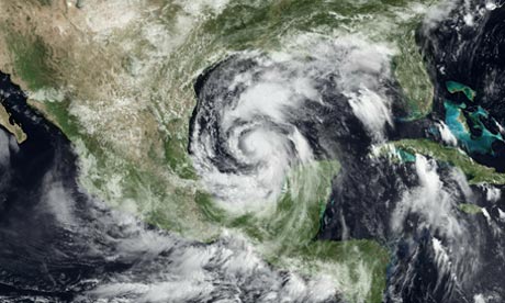
Inmiddels 112 km/uur en windstoten boven de 120 km/uur. Gaat niet lang meer duren voordat het een orkaan categorie 1 is.


Mexico gaat hard gepowned worden. Wat een gigantische storm is het toch zeg...
's Avonds een man, overdags rustig an

Hoe zit het met dat warmte gebied tussen Alex en de olievlek? Kan dit nog iets aan de richting doen veranderen? Olie wordt toch ook sneller warm? Wordt het daar niet juist gevaarlijk?
Volgens mij ligt de olievlek noordelijker, voor de kust van Louisiane richting Florida
Denk dat de koers nu wel zon beetje vast ligt en hij op de grens van Texas en Mexico aan land gaat. (in harlingen )
)
zie wel dat hij inmiddels weer opgewaardeerd is. Vanochtend gaven ze hem als cat.1 orkaan bij landfall, nu is dat inmiddels weer een categorie 2 orkaan.
Hij gaat extreem traag.. zou niet voor het eerst zijn dat ze er naast zitten qua enorme groei in kracht en dat het nog een drie wordt.
Denk dat de koers nu wel zon beetje vast ligt en hij op de grens van Texas en Mexico aan land gaat. (in harlingen
zie wel dat hij inmiddels weer opgewaardeerd is. Vanochtend gaven ze hem als cat.1 orkaan bij landfall, nu is dat inmiddels weer een categorie 2 orkaan.
Hij gaat extreem traag.. zou niet voor het eerst zijn dat ze er naast zitten qua enorme groei in kracht en dat het nog een drie wordt.
Hoge golven jagen olievegers naar de wal
(Novum/AP) - Hoge golven en aanwakkerende wind veroorzaakt door de tropische storm Alex hebben dinsdag olie-opvegende schepen in de Golf van Mexico naar de wal gejaagd. Alle opruimwerkzaamheden voor de kust van Louisiana, Florida, Alabama en Mississippi zijn opgeschort totdat het weer beter wordt.
reacties (0)printstuur artikel door
'Alex' blijft naar verwachting op ruime afstand van het olielek, maar de uitlopers van de zich ontwikkelende orkaan veroorzaken in het rampgebied harde windvlagen en metershoge golven.
De enige schepen die nog op zee zijn helpen bij het opvangen of verbranden van olie en gas, of bij het boren van een nieuw gat dat de druk op de oliespuiter moet verminderen.
Trouw
Gifje van Frutsel begint er ook steeds heftiger uit te zien. Ben benieuwd wat ons morgen brengt. Tot nu toe wordt hij niet sterker.
De eerste Juni orkaan sinds 1995 in de Atlantische Oceaan.

quote:Alex is First June Hurricane in Atlantic Since 1995
Alex not only became the first hurricane of the 2010 Atlantic season late on Tuesday, but also the first hurricane to form in June since 1995.
Alex intensified into a hurricane at 10 p.m. CDT on Tuesday when maximum-sustained winds increased to 75 mph.
Maximum-sustained winds were 80 mph at 1 a.m. CDT on Wednesday. The storm at that time was located about 195 miles east-southeast of La Pesca, Mexico, and 255 miles southeast of Brownsville, Texas.
Further strengthening should take place before Alex slams onto the northeastern Mexico coast on Wednesday evening. Prior to landfall, Alex is expected to reach Category 2 hurricane status with winds of at least 96 mph.
Alex will threaten lives and property across northeastern Mexico and South Texas by unleashing flooding rain and powerful winds. Northeastern Mexico will bear the brunt of Alex's most destructive winds.
Have a question about Alex or hurricanes in general? Ask our expert meteorologists on Facebook.
Hurricane Alex marks the beginning of what AccuWeather.com Chief Hurricane Meteorologist Joe Bastardi has forecast as an extremely active Atlantic hurricane season. Bastardi is expecting a total of 18 to 21 named storms.
The start of this 2010 Atlantic hurricane season will also go down in history books as unusually active. Alex is the first Atlantic Basin hurricane to form in June in 15 years. The last June hurricane to develop in the Atlantic was Allison in 1995.
Allison intensified into a Category 1 hurricane in the eastern Gulf of Mexico on June 4, 1995. The storm weakened back to a tropical storm less than 24 hours later, prior to making landfall along the Florida Panhandle.
In the past 43 years, August 10 is the average date when the first hurricane has formed in the Atlantic Basin. The average date for the first tropical storm is not even in June, but is actually on July 9.
quote:Op dinsdag 29 juni 2010 23:00 schreef Hydrogeny het volgende:
Gifje van Frutsel begint er ook steeds heftiger uit te zien. Ben benieuwd wat ons morgen brengt. Tot nu toe wordt hij niet sterker.
Is gifje uit de Openingspost op pagina 1
Kan nog steeds een cat.2 wordenquote:Alex is slowly strengthening, in fact, recent recon reports indicate that pressure has fallen to 959, which means Alex may become a Category 2 hurricane today.
Forecasted track is still into Mexico, with most of the energy on the right (or northern side) of the center, those in Brownsville and the Rio Grande Valley will be seeing deteriorating conditions today into tonight.
Zoals zo veel natuurfenomenen, het ziet er fantastisch uit maar dit hoef ik niet per-se aan den lijve te ondervinden. Hopelijk valt het een beetje mee en gaat het niet richting cat 3, dit zal al wel genoeg overlast veroorzaken.
be nice or go away
Ja, en je moet eens naar de Pacific kant kijken  Daar komen ze ook tot halverwege. Bijzondere orkaan dit.

Blijft aan kracht toenemen, verwacht eigenlijk wel dat hij morgenvroeg al cat 2 is. Zie nog nergens berichten van olieproblemen

videoquote:South Padre Island, Texas (CNN) -- Residents of southern Texas and northeastern Mexico braced for tornadoes and flooding as Hurricane Alex lashed a sparsely populated area south of the Texas border early Thursday morning.
The storm made landfall along the Mexican coastline late Wednesday as a Category 2 storm, about 100 miles south of Brownsville, Texas.
Maximum sustained winds were 100 mph as Alex moved to the west at 10 mph, the National Hurricane Center reported. Forecasters said the storm was expected to continue in that direction and move farther inland over northeastern Mexico Thursday.
Heavy rains could cause life-threatening flash floods and mudslides, especially in areas with mountainous terrain, the center said.
Shelters have opened throughout the Mexican state of Tamaulipas to house thousands of people affected by the rains, according to a statement from the office of the governor Wednesday night.
Tamaulipas is under "red alert," the statement said. Winds and rains from Alex are also expected to affect the Mexican states of Veracruz, Nuevo Leon and Coahuila.
Resident Claudia Aguirre told CNN that heavy rains had already caused many streets to flood Wednesday in the coastal city of Matamoros, Mexico, located across the border from Brownsville .
"We are getting bands of heavy rain and wind every 20 minutes," Matamoros resident Alexandro Hoopo said late Wednesday night.
At least 1,000 people in southern Texas were taking shelter in evacuation centers as Alex's winds and heavy rain squalls bore down on the coastline, officials in Cameron and Hidalgo counties reported.
quote:There is not much to add concerning Alex at this late hour. The hurricane made landfall as a 105 mph hurricane with a pressure of 947 millibars. This could have easily been a category three or four hurricane had it more time over water- considering the favorable upper level environment it had. Thankfully, the NHC indicates that Alex struck an area that is fairly sparse in terms of population. None the less, the people who experienced this record hurricane will never forget it
It will take some time for the large circulation of Alex to spin down and dissipate. As such, a large portion of the Gulf of Mexico coastline will continue to feel the effects until the center fills and the pressure comes up- this is already happening and will do so in a more rapid fashion throughout the day tomorrow.